Chancheng District
Chancheng District is a district and the seat of the city of Foshan, Guangdong Province, China.
Chancheng 禅城区 | |
|---|---|
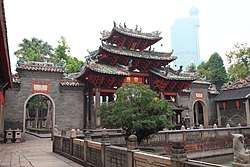 Foshan Ancestral Temple in Chancheng | |
| |
| Coordinates (Foshan government): 23°01′17″N 113°07′18″E | |
| Country | People's Republic of China |
| Province | Guangdong |
| Prefecture-level city | Foshan |
| Area | |
| • Total | 153.69 km2 (59.34 sq mi) |
| Population | |
| • Total | 960,000 |
| • Density | 6,200/km2 (16,000/sq mi) |
| Time zone | UTC+8 (China Standard) |
| Postal code | 528000 |
| Website | Chancheng.gov.cn |
| Chancheng District | |||||||||||||
|---|---|---|---|---|---|---|---|---|---|---|---|---|---|
| Simplified Chinese | 禅城区 | ||||||||||||
| Traditional Chinese | 禪城區 | ||||||||||||
| Jyutping | sim4 sing4 keoi1 | ||||||||||||
| Cantonese Yale | Sìhmsìhng Kēui | ||||||||||||
| Hanyu Pinyin | Chánchéng Qū | ||||||||||||
| |||||||||||||
| Alternative Chinese name | |||||||||||||
| Simplified Chinese | 禅城 | ||||||||||||
| Traditional Chinese | 禪城 | ||||||||||||
| Jyutping | sim4 sing4 | ||||||||||||
| Cantonese Yale | Sìhmsìhng | ||||||||||||
| Hanyu Pinyin | Chánchéng | ||||||||||||
| |||||||||||||
Geography
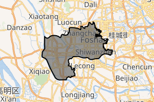
The district lies at the center of Foshan, surrounded on the east, west, and north sides by the Nanhai District and bordered to the south by the Shunde District.
Administration divisions
Chancheng is the economic, cultural and political center of the city as well as the home of the city government. The district covers a total area of 154.68 square kilometres (59.72 sq mi), and has a population of 960,000 people (including itinerant residents). Chancheng lies on relatively flat land.
| Name | Chinese (S) | Hanyu Pinyin | Population (2010)[1] | Area (km2) |
|---|---|---|---|---|
| Zumiao Subdistrict | 祖庙街道 | Zǔmiào Jiēdào | 416,800 | 31.60 |
| Shiwanzhen Subdistrict | 石湾镇街道 | Shíwānzhèn Jiēdào | 286,226 | 26.62 |
| Zhangcha Subdistrict (Foshan High-tech Industry Development Zone) | 张槎街道 | Zhāngchá Jiēdào | 241,149 | 26.50 |
| Nanzhuang town | 南庄镇 | Nánzhuāng Zhèn | 156,902 | 76.70 |
References
- Census Office of the State Council of the People's Republic of China; Population and Employment Statistics Division of the National Bureau of Statistics of the People's Republic of China (2012). 中国2010人口普查分乡、镇、街道资料 (1 ed.). Beijing: China Statistics Print. ISBN 978-7-5037-6660-2.
Guangzhou (capital) | |||||||||||||||||||||||||||||||||||||||||||||||||||||||||||||||||||||
| Sub-provincial cities |
| ||||||||||||||||||||||||||||||||||||||||||||||||||||||||||||||||||||
| Prefecture-level cities |
| ||||||||||||||||||||||||||||||||||||||||||||||||||||||||||||||||||||
| |||||||||||||||||||||||||||||||||||||||||||||||||||||||||||||||||||||
| Wikimedia Commons has media related to Chancheng District. |
This article is issued from Wikipedia. The text is licensed under Creative Commons - Attribution - Sharealike. Additional terms may apply for the media files.