List of cycle routes in London
This article provides a list of cycle routes in the Greater London area that have been waymarked with formal route signage.
The routes includes Cycleways (including Cycle Superhighways and Quietways) and the older London Cycle Network, all designated by local government body Transport for London (TfL), National Cycle Network routes designated by sustainable transport charity Sustrans, and miscellaneous Greenways created by various bodies. Most recently, in May 2020 TfL announced its Streetspace for London in response to the COVID-19 pandemic.
Note: not all these routes are dedicated 'traffic free' cycle tracks: most of them also include ordinary roads shared with motor traffic and footpaths shared with pedestrians.
Cycleways
From summer 2019, TfL started branding new cycle routes (and re-branding/consolidating some existing routes) as 'Cycleways'.[1][2] This was following feedback and criticism that the previous branding ('Superhighways'/'Quietways') was sometimes "misleading".[3]
In addition, all new and existing routes will have to meet a newer and stricter 'Cycling Quality Criteria' in order to get signed as Cycleways by TfL.[3]
Central London Cycle Grid
A partially completed scheme[4] within the central London area which includes both numbered and unnumbered Cycleways, Cycle Superhighways and Quietways.
| Name | Route | Boroughs | Comments | Approximate Length | Map |
|---|---|---|---|---|---|
| C4 | Bermondsey – Rotherhithe roundabout | Southwark | Originally announced in 2008 as Cycle Superhighway 4, construction finally began in 2019, by this time rebranded as Cycleway 4. As of May 2020, C4 is partly open along north edge of Southwark Park. The section from Tower Bridge to Southwark Park is currently under construction. Proposed to run from Waterloo, past Tower Bridge, through Deptford to Greenwich. | 520 yards, 0.5 km[5] | map |
| C6 | Kentish Town – King's Cross – Farringdon – Ludgate Circus – Blackfriars Bridge – Southwark – St. George's Circus – Elephant & Castle | Camden, Islington, Southwark | Includes all of the former 'North–South Cycle Superhighway' (CS6), plus a further northward extension to Kentish Town. There are proposals to extend C6 further north to Gospel Oak. | 5 miles, 8 km[6] | map |
| C14 | Rotherhithe | Southwark | The first section to be waymarked as C14, during March 2020, largely follows the route of NCN4. There are proposals to extend C14 along the rest of the partially-implemented Q14 route, running from London Bridge through Canada Water, and along the NCN1 Thames path through Greenwich and Thamesmead | 1.2 miles, 2 km[7] | map |
| C17 | Borough – Walworth – Burgess Park | Southwark | Northern section of what was formerly known as Q7. There are proposals to extend C17 further south into Camberwell. | 1.7 miles, 2.8 km[8] | map |
| C20 | Enfield Town – Winchmore Hill – Palmers Green | Enfield | Had originally been planned to be part of Quietway 10. There are proposals to extend C20 southwards to Wood Green in Haringey. | 6.5 miles, 10 km[9] | map |
| C23 | Lea Bridge – Bakers Arms – Whipps Cross | Waltham Forest | Upgrades an 8km section of the old LCN14 along Lea Bridge Road.[10] Construction was part of the 'mini-hollands'[11] programme. There are proposals to extend C23 westwards to Millfields Park and eastwards to Waterworks Corner. | 5 miles, 8 km[12] | map |
| C28 | Kingston High Street – Palmerston Road | Kingston upon Thames | An upgrade to part of the old LCN3 route; initially waymarked as Quietway Q19 before being rebranded as Cycleway 28 in December 2019. | 1500 yards, 1.4 km[13] | map |
| C31 | New Malden – Raynes Park | Kingston upon Thames, Merton | First section between New Malden and Raynes Park opened on 13 July 2019. There are proposals to extend this to Wimbledon. | 1.6 miles, 2.7 km[14] | map |
| C34 (under construction)[15] |
Acton – East Acton – Wood Lane | Ealing, Hammersmith & Fulham | Construction started in March 2019. First section opened in May 2020. This route was formerly planned to be Cycleway 10.[16] | OSM | |
| C39 | Shepherd's Bush – Kensington Olympia | Kensington & Chelsea | Opened in spring 2020. | 1300 yards, 1.2 km[17] | map |
| Link routes (C) |
Central London Grid (various) | Camden, City of London | Cycleway link routes are usually way-marked with an un-numbered C: | ||
Cycle Superhighways
London's Cycle Superhighways were a set of Bike freeways, that were aimed principally at commuters and more experienced cyclists, providing faster and more direct radial routes between outer and central London.[1] In addition to route signage with a pink logo, other distinctive features included blue cycle lanes on some of the routes (the brand colour of the scheme's original sponsor, Barclays) and 'totem' style signage pillars.
History
London's Cycle Superhighways were first announced in 2008 by Mayor Ken Livingstone.[18] The original proposal consisted of 12 radial routes, with routes numbered in 'clock face' fashion[19] however several of these proposed routes were never built, seeing opposition from the respective London boroughs.[20] Initial implementation of the cycle superhighways also drew criticism on safety grounds, with poor design at some junctions, insufficient segregation of cyclists from motor traffic and slippery surfaces all contributing to numerous fatalities[21][22][23][24].
In 2018 TfL dropped the 'cycle superhighway' name from use on any further projects. All the existing Cycle Superhighways are now part of the Cycleways network and each will get rebranded as a numbered 'Cycleway' in due course.
| Name | Route | Comments | Approximate Length | Map |
|---|---|---|---|---|
| CS1 | Tottenham – Seven Sisters – Stamford Hill – Stoke Newington – Dalston – De Beauvoir – Hoxton – The City (A10) | Was completed in April 2016.[25] This route does not use 'blue paint' and is primarily non-segregated on quieter streets (often following the route of the older LCN10), and is thus more similar to the Quietways. | 7.5 miles, 12 km[26] | map |
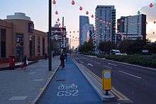
| CS2 | Stratford – Stratford High Street – Bow Church – Bow Road – Mile End – Stepney Green – Whitechapel – Aldgate East – City (A118 – A11) | An upgrade to the old LCN11 route, CS2 initially consisted mostly of 'blue paint' cycle lanes. In 2016, after safety concerns and fatalities, the majority of the route was further upgraded to separated cycle tracks .[27] | 4.3 miles, 6.8 km[28] | map |
| CS3 | Barking – North Beckton – Prince Regent Lane – Canning Town – East India – Blackwall – Poplar – Canning Town – Westferry – Shadwell – Tower Gateway (A13 – A1202 – A3211 – Hyde Park – A402 – A4209) – Blackfriars – Embankment – Westminster – Hyde Park – Lancaster Gate | The section from Barking to Tower Hill uses 'blue paint' and was largely an upgrade to the old LCN13 route. Sustrans' have also designated much of this stretch as being part of their NCN13. In 2017, TfL constructed a lengthy extension of CS3 (dubbed 'CS3 East West') to Lancaster Gate. This section does not use blue paint. | 15 miles, 24 km[29] | map |
| CS5[30] | Oval – Vauxhall – Vauxhall Bridge – Pimlico (A202) | On the original 2008 proposals, CS5 was intended to run from Lewisham to Victoria, however only the short segregated stretch from Pimlico to Oval was built. | 1 mile, 1.7 km[31] | map |
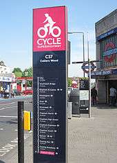
| CS7 | Colliers Wood – Tooting Broadway – Tooting Bec – Balham – Clapham South – Clapham Common – Clapham High Street – Clapham North – Stockwell – Oval – Kennington – Elephant & Castle – Southwark Bridge – City (A24 – A3) | This route uses 'blue paint' but features few separated lanes. | 8.5 miles, 14 km[32] | map |
| CS8 | Wandsworth High Street – Wandsworth Town – Battersea High Street – Battersea Park – Chelsea Bridge – Vauxhall Bridge – Lambeth Bridge (A3 – A3205 – Vauxhall Cross) | This route uses 'blue paint' but features few separated lanes. | 6 miles, 10 km[33] | map |
Quietways
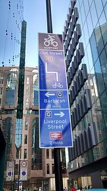
First announced in 2015, TfL's Quietways[34] targeted less confident cyclists who want to use routes with less traffic, whilst also providing for existing cyclists who want to travel at a more gentle pace. The route numbers were shown in purple on signs.
The scheme lasted only three years before TfL decided to drop the Quietways brand, using 'Cycleways' for further new routes. All of the delivered Quietways are now formally part of the Cycleways network and TfL have indicated that the existing Quietways will be gradually rebranded as a 'Cycleways' (and renumbered in most cases).
| Name | Route | Boroughs | Comments | Map |
|---|---|---|---|---|
| Q1 | North section: Bloomsbury – Holborn – Covent Garden;[35] South section: South Bank – Waterloo – Borough – Bermondsey Spa – South Bermondsey – Deptford – Greenwich |
City of Westminster, Lambeth, Southwark, Lewisham | Will get rebranded as Cycleway 10. North section: Streetspace for London plans[36] include fast-tracking of a planned Q1 extension to Hampstead Heath via Euston and Camden Town. Missing section over River Thames: Streetspace for London plans[36] include possible road restriction to only cyclists and buses on Waterloo Bridge.[36] South section: South Bank to Greenwich; route is diverted around The Den on Millwall match days. An extension to Bexleyheath via Falconwood is under construction in Greenwich and Bexley. Much of the existing route was an upgrade to portions of LCN 2 and LCN 22; Q1 also shares some of its route with Sustrans' NCN425. |
Q1(N) Q1(S) map |
| Q2 | West section: East Acton – Wormwood Scrubs – North Kensington – Notting Hill – Bayswater – Paddington; East section: Bloomsbury – Clerkenwell – Angel – Canonbury – De Beauvoir Town – London Fields – Clapton – Lea Bridge – Walthamstow Wetlands – Walthamstow Central |
Hammersmith & Fulham, Kensington & Chelsea, Islington, Hackney, Waltham Forest | Will get rebranded as Cycleway 27. West section: An extension to Fitzrovia is under construction in Westminster. Some of the awaited route through Camden already has C27 road markings instead. East section: Bloomsbury to Walthamstow. |
Q2(W) Q2(E) map |
| Q3 | Gladstone Park (Dollis Hill) – Kilburn) | Brent | Originally planned to link Gladstone Park with Regent's Park, however Camden and Westminster boroughs have not yet implement their sections of the route. Approximately half of the implemented section is an upgrade to the old LCN 48. | Q3 map |
| Q4 | Clapham Common to Wimbledon | Lambeth, Wandsworth, Merton | Although most of the route has been built, the only part to be signed is a single crossing. | Q4 map |
| Q5 | Lambeth North – Oval – Stockwell – Clapham Common | Lambeth, Wandsworth | Initially planned to link Waterloo to Croydon, only the section from Lambeth North to Clapham Common has been launched as Q5. Existing route is to get rebranded as a future Cycleway 5. | Q5 map |
| Q6 | Manor Park – Aldersbrook – Valentines Park – Barkingside | Redbridge | Valentines Park is closed at night. Q6 was planned to extend from Mile End to Barkingside, but Tower Hamlets council's originally proposed section was not approved by TfL. | Q6 map |
| Q7 | Dulwich | Southwark | Only a single junction in Dulwich remains with Q7 signage. With the Q7 section north of Burgess Park becoming C17 during summer 2019, this was the first existing Quietway to get partly renumbered and rebranded as a 'Cycleway'. Only LCN 23 road markings remain between C17 and Camberwell for now, as all previous Q7 road markings and signage have been removed. |
Q7 OSM map |
| Q8 | Burgess Park | Southwark | Short portion of route along a widened path inside Burgess Park (labelled on TfL's online cycle map but not waymarked on the ground). Will become Cycleway 36. | map |
| Q11 | Angel – Old Street – City of London (CS3/CS7) | Islington, Hackney, City of London[37] | Runs from Q2 to Southwark Bridge (connecting to CS3 and CS7). Although proposed works for Q11 are yet to be implemented by Islington council, the route is partly signed there. | Q11 map |
| Q13 | Old Street – Shoreditch – Broadway Market | Islington, Tower Hamlets, Hackney[38] | Connects Q11 to Q2. Although proposed works for Q11 or Q13 are yet to be implemented by Islington council, both routes are partly signed there. | Q13 map |
| Q14 | West section: Blackfriars Road – Borough – London Bridge – Tower Bridge Road East section: Charlton Riverside – Woolwich – Thamesmead[39] |
Southwark, Greenwich | Originally proposed as a continuous route from Waterloo to Erith (sometimes referred to as Jubilee Quietway). However only two sections were implemented as Q14: one in Southwark, and a riverfront section from the Thames Barrier to Woolwich opened in June 2018 (largely along NCN1).[40] In March 2020 newer sections of the proposed route began to get signed as C14. | Q14 map |
| Q15 | Brompton Cemetery – Earl's Court – South Kensington – Chelsea | Kensington & Chelsea | A proposed extension to Belgravia has yet to be implemented by Westminster council. | Q15 map |
| Q16 | West Drayton – Stockley Park – North Circular Road – Old Oak Lane – Regent's Canal | Canal & River Trust | Majority of route will be along Grand Union Canal towpath. Improvements along the towpath were scheduled to be completed in 2020.[41] | OSM map |
| Q22 | Stratford High Street (CS2) – West Ham – Plaistow – East Ham – North Beckton (CS3) | Newham | An upgrade to the section of LCN 16 along The Greenway connecting CS3 and CS2. (As a future Cycleway) this route is planned to be extended to Victoria Park. | Q22 map |
| Link routes (Q) |
Central London Grid (various) | Lambeth, Kensington & Chelsea, Westminster, City of London, Islington, Hackney | Routes are way-marked with an un-numbered Q. Notable link routes include:
| |
| Queen Elizabeth Hospital – Woolwich Town Centre | Greenwich, Lewisham | Will be a link to a future 'Woolwich to Lee Green' Cycleway route. | map | |
Streetspace for London
In May 2020, in response to the COVID-19 pandemic and the resulting need to maintain social distancing, TfL announced a programme of measures that includes additional cycling provision.[42] Some of these measures are described as 'temporary', although others appear to include fast-tracking of permanent cycle routes. Notable routes delivered under this programme have so far included:
London Cycle Network Plus

The London Cycle Network Plus (LCN+) aimed to provide a 900 kilometre network of cycle routes throughout Greater London. It was funded by Transport for London and managed by the LCN+ Project Team at the London Borough of Camden. It was launched in 2001, replacing the earlier London Cycle Network (LCN) project, and wound up in 2010.
Although some LCN routes have been upgraded to TfL's new Quietways and Cycle Superhighways, the majority throughout Greater London still exist and are signposted and/or indicated by carriageway markings (although not all the signage uses route numbers). Where route numbers are used in signs, this is usually the LCN route number, but on some route sections the 'LCN+ link' number has been used on signs. (LCN+ link numbers were usually internal reference numbers used for project management.)[44]
London Cycle Network routes
The LCN route numbering used a radial and orbital scheme, as shown by the groupings in the table below. Some routes were also part of the Sustrans National Cycle Network – these are signposted with route numbers on a red background.[45] There were also a comparable number of un-numbered routes in the scheme. These are not listed in the table below.
The last edition of the LCN route map to be published was the 5th edition (2004).[46]
| Orbital routes in Central zone: | |||
|---|---|---|---|
| Route Number | Route | Notes | Map |
| 0 (Seven Stations Circular) | City (→ Liverpool St.) – (Waterloo) – Westminster – Marylebone (→ Paddington) – Bloomsbury (→ Euston) – (→ King's Cross) – Finsbury – The City | Three sections are now part of new TfL routes: south side of Green Park: East-West CS3 Elephant and Castle to the north end of Southwark bridge: CS7 Southwark Bridge to Old Street: Q11 | map |
| Radial routes in Central zone: | |||
| Route Number | Route | Notes | Map |
| 1 (NCN) | Dartford – Greenwich – (Lea Valley) – Waltham Abbey | Greater London portion of Sustrans NCN 1 | see NCN1 map below |
| 2 (A2) | Blackfen – Falconwood – Eltham (Route 2a is via Eltham station) – Kidbrooke – Blackheath – Greenwich – Deptford – Old Kent Road – Elephant & Castle | Some sections are now Sustrans NCN 425 and Quietway Q1 (see above) | map |
| 3 (old A3) | (Esher – Ditton) – Kingston – Wandsworth – Battersea – Clapham Common – Stockwell – Oval – Waterloo | Some sections will become TfL Quietways Q4 , Q5 . A section in Kingston is now C28 (see above) | map |
| 4 (NCN) | Greenwich – Westminster / Central London – (Barnes) – Kingston – Windsor | Greater London portion of Sustrans NCN 4 | see NCN4 map below |
| 5 (old A5) | (Elstree) – Edgware – Kilburn – Maida Vale – Marylebone – Hyde Park – Knightsbridge – Chelsea Bridge – Battersea – Clapham – Streatham – Norbury – Croydon | Portions in South London will become TfL Quietway Q5 . Section across Chelsea Bridge/alongside Battersea Park is now Cycle Superhighway CS8 | map |
| 6 | Barnet – Alexandra Palace – Holloway – Tufnell Park – Camden Town – West End – Waterloo | map | |
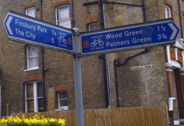
| 7 | Elephant & Castle – City – (Finsbury Park) – Wood Green – (Southgate) | Section past Finsbury Park is NCN 162 . Section from St George's Circus, across Blackfriars Bridge along Farringdon Road is now C6 | map |
| 8 | Hammersmith – (Paddington) – (Angel) – London Fields – Hackney – Leyton – Leytonstone – (Woodford) | Includes Market Porters & 7 Stations. The portion between King's Cross Road and London Fields is now TfL Quietway Q2 | map |
| 9 | Epping – (Chingford) – Walthamstow – Hackney – London Fields – Broadway Market – City | The portion between London Fields and Millfields Park South is now Quietway Q2 ; between Virginia Road and the Regent's Canal is now Quietway Q13 . | map |
| Radial routes in North East London: | |||
| Route Number | Route | Notes | Map |
| 10 (A10) | Waltham Cross – Enfield – Tottenham – Seven Sisters – Stoke Newington – The City | The majority of this route between the City and Tottenham has been upgraded to form Cycle Superhighway CS1 | map |
| 11 (A11) | Epping – (Woodford) – Leytonstone – Stratford – City | This route has been updated to form Cycle Superhighway CS2 between Aldgate and Stratford | map |
| 12 (A12) | Romford – Ilford – Stratford – City | map | |
| 13 (A13) | Tilbury – Rainham – (Canning Town) – City | Part of this route has now been upgraded to form part of Cycle Superhighway CS3 . | map |
| 14 (A104) | Clapton – Lea Bridge – Whipps Cross – Woodford | A portion of the route has been upgraded to C23 . | map |
| 15 | (Upminster) – Barking – Plaistow – Canning Town – City | The section between Tower Bridge and Canning Town has been upgraded to form Cycle Superhighway CS3 | map |
| 16 | Newham Greenway, Beckton – West Ham – Stratford – Victoria Park – Cambridge Heath | The section along The Greenway is now Quietway Q22 | map |
| Radial routes in South East London: | |||
| Route Number | Route | Notes | Map |
| 17 | Greenwich Park – Lewisham – Catford – Beckenham, West Wickham | Shares route of Sustrans NCN 21 (Waterlink Way) between Elverson Road DLR station and Loampit Vale, Lewisham | map |
| 18 | Dartford – Erith – Woolwich – Greenwich | map | |
| 19 | Dartford – Bexleyheath – Plumstead – Greenwich – Charlton | map | |
| 20 (A20) | Swanley – (Chislehurst) – Lewisham – (Deptford) – (Surrey Docks) | Includes a short section in central Lewisham that follows the route of NCN 21 | map |
| 21 (Waterlink Way) | Greenwich – Lewisham – Catford – (Elmers End) – (New Addington) – Crawley | Greater London portion of Sustrans NCN 21 | see NCN21 map, below |
| 22 | Orpington – Bromley – Catford – Peckham Rye – Central London | One section in Bermondsey (Willow Walk/Lynton Road) is now part of Quietway Q1 | map |
| 23 (A23) | Purley – Croydon – Crystal Palace – (Camberwell) – Central London | Northern section (Elephant and Castle to Southwark Bridge) is now TfL Cycle Superhighway CS7 . The proposed Quietway Q2 follows some of LCN 23 too. | map |
| 24 | Carshalton – (Wandsworth) | map | |
| 25 South Circular | Woolwich – Catford – Dulwich Village – Herne Hill – Clapham Common – (Barnes) | map & map (25a) | |
| 26 | Eltham – Crystal Palace – Streatham – (Wandsworth) – Hammersmith – (Willesden) | In reality this route is a 'orbital' one in south London from Shepherds Bush in the west, to Eltham in the south east, however it is non-continuous with several gaps. | map |
| 27 (Part A21) | Sevenoaks – Bromley – Crystal Palace – Battersea | map | |
| 28 | Bromley – Lee – Greenwich | map | |
| Radial routes in South West London: | |||
| Route Number | Route | Notes | Map |
| 29 | Sutton – Wimbledon – Wandsworth | map | |
| 30 | A30, Staines – (Osterley) | map | |
| 31 | A3 Kingston by-pass parallel, Leatherhead – (Hook) – (New Malden) – Hammersmith | map | |
| 32 | (Ewell) – Kingston – (Whitton)? – Hounslow – Hayes | map | |
| 33 | Leatherhead – (Chessington) – Kingston – Richmond | map | |
| Radial routes in North West London: | |||
| Route Number | Route | Notes | Map |
| 34 | (Sunbury) – Hounslow – (Southall) | map | |
| 35 | A315 – Staines – Hounslow – (Chiswick) – Hammersmith | map | |
| 36 | A316 – (Sunbury) – Twickenham – Hammersmith | The section between Woodberry Wetlands and Walthamstow Wetlands was branded the 'Wetlands to Wetlands Greenway' in 2016. | map |
| 37 | A316 parallel, (Feltham) – Twickenham – Richmond – (Wandsworth) – Central London | map | |
| 38 | Wimbledon – Putney – Westminster | Short section past Victoria will be part of Quietway Q15 | map |
| 39 | A4020 Uxbridge Road – Uxbridge – Southall – Hanwell – Ealing – (Shepherd's Bush) – Hyde Park – Mayfair – West End | map | |
| 40 | A40 (Hillingdon) – (Greenford) – (Hanger Lane) – Bayswater – Paddington – Central London | map | |
| 41 | Uxbridge Road parallel, (Acton) – Ealing – (Hayes) | map | |
| 42 | Grand Union Canal, Westminster – (Hayes) | ||
| 43 | (Grand Union Canal, West Drayton) – (Hayes) – (Brentford) | ||
| 44 | A4 – Slough – (Osterley) – Hammersmith – (Hyde Park Corner) | map | |
| 45 | Harrow – Wembley – Kensington – Battersea | map | |
| 46 | (Fulham) – (Willesden) | map | |
| 47 | (Queen's Park) – Wembley – (Kenton) | map | |
| 48 | Kilburn – Wembley – (Kingsbury) – (Stanmore) | The eastern half of this route is now Quietway Q3 . | map |
| 49 | (Hendon) – Harrow – (Pinner) – (Northwood) | map | |
| 50 | St James's Park – Marylebone – Regent's Park – (Hendon) – Potters Bar | map | |
| 51 | (Friern Barnet) – (Golders Green) | map | |
| Orbital routes in North East London: | |||
| Route Number | Route | Notes | Map |
| 54 | Muswell Hill – Wood Green – Tottenham Hale – Walthamstow | map | |
| 55 | Barking – Ilford – (Wanstead) | map | |
| 56 | Wood Green – Northumberland Park | The section between Bruce Castle Park and White Hart Lane stadium is now Cycle Superhighway CS1 | map |
| 57 | Dagenham – Chigwell Row – Epping | map | |
| 58 | (Rainham) – Romford – Epping | map | |
| 59 | (Rainham) – (Harold Hill) | Proposed route, never implemented (?) | OSM map |
| 60 | Collier Row | map | |
| 61 | Romford – (Bedfords Park) | map | |
| Orbital routes in South East London: | |||
| Route Number | Route | Notes | Map |
| 62 | Greenwich – (Forest Hill) – Sydenham – Penge | Route signage does not use the route number | map |
| 63 | Greenwich – Bromley | map | |
| 64 | The O2 – (Mottingham) | map | |
| 65 | Kennington – Peckham Rye – Ladywell – Eltham | Shares route through Ladywell Fields with NCN 21 | map |
| 66 | Thamesmead – Plumstead Common – Falconwood – New Eltham – Chislehurst – Petts Wood | map, map (66a) & map (66b) | |
| 67 | Bromley (Chislehurst) – Woolwich | map | |
| 68 | Bexley – (Abbey Wood) | map & map (68a) | |
| 69 | Orpington – (Bexley) – Dartford | map | |
| Orbital routes in South West London: | |||
| Route Number | Route | Notes | Map |
| 71 | East Sheen Common – Roehampton – Wimbledon Park | map | |
| 73 | Croydon – Wimbledon – Richmond | map | |
| 74 | Streatham – Wimbledon – Kingston – Feltham – Heathrow | map | |
| 75 | Woolwich – Eltham – Bromley – Croydon – Sutton – Kingston – Twickenham – Ealing | map | |
| 76 | Orpington – Croydon – Sutton – (Ewell) | map | |
| 77 | (New Beckenham) – (South Croydon) – (Ewell) | map | |
| 78 | Forestdale – Sanderstead | map | |
| Orbital routes in North West London: | |||
| Route Number | Route | Notes | Map |
| 84 | (Park Royal) – (Hendon) | ||
| 85 | Barnet – Hendon – (Hanger Lane) – Ealing | map | |
| 86 | (Brentford) – Ealing – (Perivale) – (Sudbury) | map | |
| 87 | (Brentford) – Hanwell – Greenford Broadway – (Rayners Lane) | map | |
| 88 | A312, Feltham – (Hayes by pass), – (South Ruislip) – (Rayners Lane) – Edgware | map & map (88a) | |
| 89 | (Heathrow) – (West Drayton) – Uxbridge – (Hatch End) – (Stanmore) – Barnet | map | |
| 99 | Hatton – Feltham | Signposted as 99, but is really a completed section of Hounslow's LCN link +99 | map |
National and international routes
National Cycle Network routes

The sustainable transport charity Sustrans describe their National Cycle Network (NCN) as "a network of safe traffic-free paths and quiet on-road cycling" that "criss-cross the country, linking up villages, towns and cities".[47] Several of these NCN routes pass through London. NCN routes are signed with white lettering on a blue background, with route numbers having a red background.[48]
| Route Number | National Route Description | Route through London | Notes | OpenStreetMap reference |
| NCN1 | Shetland to Dover | Waltham Abbey (town) along the River Lea via Tottenham to the Isle of Dogs, through Greenwich Foot Tunnel, Thames Path from Greenwich to Dartford | Also serves as part of international route EV2 (see below), and was London Cycle Network + route LCN1. In 2019, a section in Greenwich was co-designated Q14. | map map |
| NCN12 | Enfield Lock to Spalding, Lincolnshire[49] | Enfield Lock to Hadley Wood | Currently under development as the "Enfield Island Village to Hadley Wood Greenway"[50] | map |
| NCN125[51] | – | Dartford: River Thames to Brooklands Lake along the River Darent | Opened in 2012. | map |
| NCN13 | London to Norwich | Tower Bridge – Barking (Royal Docks) – Rainham – Purfleet | shares part of its route with TfL CS3 | map |
| NCN136 | — | Rainham to Noak Hill via Upminster | map | |
| NCN162 | — | North London: Finsbury Park to Highbury Fields | Shares most of its route with the old LCN7. The route is not way-marked as 'NCN162' on the ground – this designation only exists on Sustrans mapping. | map |
| NCN177 | — | River Thames to South Coast in Kent | Currently open between Northfleet and Rochester, and between Downswood and the western edge of Mote Park. | map |
| NCN20 | London to Brighton | Wandle Trail from Wandsworth – Carshalton, then on to Coulsdon | The international Avenue Verte from London to Paris follows NCN20; TfL Quietway Q4 shares the route of NCN20 between Earlsfield and the Wandle Meadow Nature Park | map |
| NCN208 | — | Raynes Park to Morden | map | |
| NCN21 | London to Eastbourne | Waterlink Way from Greenwich – Lewisham – Catford – (Elmers End) – (New Addington) – Crawley | map | |
| NCN212 | — | Wandle Park to Ashburton Park through central Croydon | Croydon Parks Link, sections opened 2016, 2017 | map map |
| NCN232 | — | Wandle Park to Lloyd Park through central Croydon | Croydon Parks Link, sections opened 2016, 2017 | map |
| NCN4 | Fishguard to London | Thames Path between Greenwich and Windsor | Also serves as part of international route EV2 (see below), and was London Cycle Network + route LCN4. In March 2020, a section in Bermondsey was co-designated as TfL's C14. | map |
| NCN425 | — | Burgess Park in Camberwell to Durand's Wharf in Rotherhithe | 8.1 km route built with a grant from the National Lottery. Some of the central section also became part of Quietway Q1. | map |
International Cycle Network routes
Additionally, some portions of these NCN routes have also been co-opted by the European Cyclists' Federation as forming part of their international EuroVelo network:
- EV2 The Capitals Route which runs from Galway in Ireland to Moscow in Russia, follows the course of NCN4 along the River Thames from west London to Greenwich, and then NCN1 northwards to Harwich
- The Avenue Verte international route from London to Paris begins in central London, largely following Sustrans route NCN20 within the Greater London area.
Greenways
London's "Greenways" are a loosely defined collection of mostly traffic-free shared cycling and walking routes, predominantly within (or connecting to) various parks and open spaces within Greater London. TfL and Sustrans claimed that "Greenways should be suitable for use by a novice adult cyclist, a family with young children or a sensible, unaccompanied 12-year-old".[52][53]
Greenways in London have been developed by numerous different bodies, including Sustrans (who began the Greenways initiative in 1994[54]), Transport for London, the Canal and River Trust, the London Boroughs, the Royal Parks, the Lee Valley Regional Park Authority and the 2012 Olympic Delivery Authority, under various different funding programmes (including the 2009–2014 London Greenways scheme, the 2012 Games Walking and Cycling Routes programme[55], 'Connect2', the National Cycle Network, and others).
The routes tend to have names rather than numbers, and many of them use waymarking signs or markers in the carriageway, but there is no consistent scheme covering all of them. Some of the Greenways have been co-opted into the other TfL or Sustrans schemes listed earlier in this article.
The table below lists the most notable Greenways in London.
| Name | Description | Map |
|---|---|---|
| Routes in or connecting to parks, green spaces and nature reserves: | ||
| Tamsin Trail.[56] | Circular route around Richmond Park | map |
| Avery Hill Park | New and improved cycling and walking routes through this park in Greenwich. | map |
| Ravensbourne Greenway | Route alongside the River Ravensbourne through Beckenham Place Park in Lewisham. | map |
| ‡ Hackney Parks | Connects Finsbury Park, Clissold Park, Hackney Downs, Victoria Park and the Queen Elizabeth Olympic Park at Stratford. Some of the section between Hackney Downs and Victoria Park is now Q2. | map |
| Redbridge Greenway.[57] | map | |
| River Beam Bridge | Shared-use foot/cycle bridge over the River Beam, linking the Beam Valley Country Park with Bretons Outdoor Centre. | map |
| Feltham Park, Longford River | New bridge and improved shared use paths. | |
| Jubilee Greenway, Woolwich Foot Tunnel | Various infrastructure improvements on the Jubilee Greenway and associated routes between CS3 and the Woolwich Foot Tunnel. | |
| Greendale Extension | New link from the Greendale (LCN23) to Ruskin Park. | |
| ‡ Epping Forest Greenway | Route from Stratford to Epping Forest. Skirts the boundaries of West Ham cemetery, Wanstead Flats, Harrow Road playing fields, Bush Wood and Leyton Flats. | map |
| Wetlands to Wetlands Greenway | Cycling route between Woodberry Wetlands and Walthamstow Wetlands. Much of the on-road section between the two wetlands follows the route of LCN36. | map |
| Stanmore to River Thames Greenway | Proposed Greenway with some completed sections, included Proyer's Path through Northwick Park, Harrow. | |
| Enfield Chase to Arnos Park Greenway | Route in Enfield linking several green spaces Enfield Golf Club and Grovelands Park. | |
| Durant's Park to Brimsdown Greenway | Route in Enfield | |
| River corridors: | ||
| Roding Valley Way.[58] | Follows the green corridor of the River Roding. | map |
| The Wandle Trail | Follows the green corridor of the River Wandle. Cycle and walking sections sometimes diverge; the cycle sections are mostly part of NCN20. | map |
| Hogsmill River Greenway | Greenway linking Tolworth and Old Malden | map |
| ‡ Lower Lea Valley | Runs from the Olympic Park via the Greenway in Newham to the Greenwich Foot Tunnel on the Isle of Dogs. | map |
| Sewer corridors: | ||
| ‡ Newham Greenway | Also known as the 'Elevated Greenway'. Route from Stratford to Beckton built on top of the Northern Outfall Sewer. Most of the route is now designated Q22 (formerly LCN16)–see above. | |
| The Ridgeway | Route from Plumstead to Crossness built on top of the Southern Outfall Sewer. | |
| Canal towpaths: | ||
| ‡ Lee Valley North | Sections of the River Lee towpath, upgraded for the 2012 Olympics | map |
| Regent's Canal towpath. | Towpath of a portions of the Regent's Canal | |
| ‡ Limehouse Cut | Towpath of the Limehouse Cut waterway. | map |
‡ These routes were developed for the 2012 Summer Olympic Games
See also
- Cycling in London
- Santander Cycles
- National Cycle Network
- Cycleways in England
- List of cycleways
- London greenways
- Segregated cycle facilities
References
- Matters, Transport for London | Every Journey. "Cycleways". Transport for London.
- "Cycle superhighways rebranded to banish the image of Lycra louts". Evening Standard. 17 December 2018.
- "Four new Cycleways to launch, enabling more people to join the capital's cycling boom". Transport for London. 12 September 2019. Retrieved 16 September 2019.
- "Central London Cycle Grid".
- Waymarked Trails: Cycling https://cycling.waymarkedtrails.org/#route?id=8405154. Retrieved 29 May 2020. Missing or empty
|title=(help) - Google Maps https://www.google.com/maps/dir/Elephant+and+Castle,+London/Kelly+St,+Kentish+Town,+London/@51.4963271,-0.1049341,17.72z/data=!4m64!4m63!1m55!1m1!1s0x487604a23d99f27f:0x1a4907e34b872655!2m2!1d-0.1004748!2d51.4959129!3m4!1m2!1d-0.105815!2d51.497954!3s0x487604bcc823a5c5:0x113b508d33e0aae7!3m4!1m2!1d-0.1056543!2d51.5194515!3s0x48761b520bc909b1:0xa7d8ec2243f0cdc1!3m4!1m2!1d-0.1143525!2d51.5257503!3s0x48761b462cbddd01:0x965880403944c8d0!3m4!1m2!1d-0.1144549!2d51.5267805!3s0x48761b464af36c9f:0x98eaf832b06a4d48!3m4!1m2!1d-0.117471!2d51.5278836!3s0x48761b47874e5cdd:0x15abeb0e6c01c333!3m4!1m2!1d-0.1211233!2d51.526676!3s0x48761b39c8257cc9:0x90d36e00c46f080f!3m4!1m2!1d-0.1233284!2d51.5268227!3s0x48761b398aeee3f9:0x78dcb1e2ccbce07a!3m4!1m2!1d-0.1252921!2d51.5281103!3s0x48761b3a4a3dce93:0x333ff7951724cb0b!3m4!1m2!1d-0.1317883!2d51.5349672!3s0x48761b228e88e117:0xe7796e13adf8a3e4!3m4!1m2!1d-0.1381394!2d51.5414847!3s0x48761b1c2b112d9d:0x53bd8ca956b57eec!1m5!1m1!1s0x48761ae2c7daf869:0x7826b8c010aeb41b!2m2!1d-0.1425189!2d51.5456013!3e2. Retrieved 29 May 2020. Missing or empty
|title=(help) - Waymarked Trails https://cycling.waymarkedtrails.org/#route?id=9201162. Retrieved 29 May 2020. Missing or empty
|title=(help) - Waymarked Trails https://cycling.waymarkedtrails.org/#route?id=10068590. Retrieved 29 May 2020. Missing or empty
|title=(help) - Road.cc https://road.cc/content/news/266518-extension-londons-cycleway-6-officially-opens-more-routes-due-soon. Retrieved 29 May 2020. Missing or empty
|title=(help) - "Following international award night, Waltham Forest Council announces extension to successful schemes". Waltham Forest Council. Retrieved 10 July 2019.
- "Mini-Hollands". Transport for London.
- Road.cc https://road.cc/content/news/266518-extension-londons-cycleway-6-officially-opens-more-routes-due-soon. Retrieved 29 May 2020. Missing or empty
|title=(help) - Waymarked Trails https://cycling.waymarkedtrails.org/#route?id=7867560. Retrieved 29 May 2020. Missing or empty
|title=(help) - Waymarked Trails https://cycling.waymarkedtrails.org/#route?id=7428562. Retrieved 29 May 2020. Missing or empty
|title=(help) - "Four new Cycleways to launch, enabling more people to join the capital's cycling boom". Transport for London. Retrieved 12 September 2019.
- http://content.tfl.gov.uk/tfl-commissioners-report-27-march-2019.pdf#page=19
- Waymarked Trails https://cycling.waymarkedtrails.org/#route?id=10068787. Retrieved 29 May 2020. Missing or empty
|title=(help) - Taylor, Matthew (9 February 2008). "City's two-wheel transformation". The Guardian. Retrieved 11 August 2010.
- "Barclays Cycle Superhighways Map" (PDF). ECO dalle CITTA. Retrieved 28 May 2016.
- "Cycle Superhighway 11".
- Montgomery, Charles (15 November 2013). "London's 'cycling superhighways' are ideal … for kamikazes". Retrieved 25 June 2014.
- Urquhart, Conal (17 November 2013). "Five cyclists dead in two weeks: is there a way to make London's roads safer?" – via www.theguardian.com.
- Matters, Transport for London | Every Journey. "Innovative Cycle Superhighway junction in UK safety first". Transport for London.
- "Coroner urges 'slippy' cycle lane review". BBC News. 13 March 2017 – via www.bbc.co.uk.
- "TfL and Hackney Council to trial traffic reduction schemes to complement Cycle Superhighway 1". Transport for London. 22 July 2016. Retrieved 5 November 2016.
- Waymarked Trails: Cycling https://cycling.waymarkedtrails.org/#route?id=11047842. Retrieved 28 May 2020. Missing or empty
|title=(help) - "Cycle Superhighway 2 upgrade". Transport for London. Retrieved 2 August 2015.
- (PDF) http://content.tfl.gov.uk/bcs2-map.pdf. Retrieved 28 May 2020.
(Not
Missing or empty|title=(help) - https://cycling.waymarkedtrails.org/#route?id=1159230. Retrieved 28 May 2020. Missing or empty
|title=(help) - "Cycle Superhighway 5 - Transport for London". web.archive.org. 9 September 2015.
- https://cycling.waymarkedtrails.org/#route?id=4712210. Retrieved 28 May 2020. Missing or empty
|title=(help) - https://cycling.waymarkedtrails.org/#route?id=1077494. Retrieved 28 May 2020. Missing or empty
|title=(help) - https://cycling.waymarkedtrails.org/#route?id=1266651. Retrieved 28 May 2020. Missing or empty
|title=(help) - "Quietways". Transport for London. Retrieved 10 November 2015.
- "Quietway 1 (North) – Covent Garden to Kentish Town" (PDF). Transport for London.
- "Streetspace for London". Transport for London. Retrieved 30 May 2020.
- "Public reports pack 21062016 1130 Streets and Walkways Sub (Planning and Transportation) Committee" (PDF). City of London Corporation. p. 27.
- "Rivington Street and Charlotte Road – Hackney Council Consultation" (PDF). Hackney Council.
- "Update on the implementation of the Quietways and Cycle Superhighways programmes" (PDF). Transport for London. 30 November 2016. Retrieved 1 December 2016.
- Napier, Russell. "The Missing Link is missing no more". www.royalgreenwich.gov.uk. Retrieved 22 June 2018.
- "Quietways – cycling in London". Canal & River Trust. Retrieved 16 June 2019.
- Streetspace for London. TfL https://tfl.gov.uk/travel-information/improvements-and-projects/streetspace-for-london. Retrieved 29 May 2020. Missing or empty
|title=(help) - Waymarked Trails https://cycling.waymarkedtrails.org/#route?id=11146489. Retrieved 30 May 2020. Missing or empty
|title=(help) - "London Cycle Network Plus (LCN+): Route alignment alternatives, night-time routes and LCN+ 'Spurs'" (PDF). 29 September 2007.
- "Currently issued and used LCN Route Numbering and Destinations". LCN+ Maps Website. London Cycle Network. Archived from the original on 4 October 2013. Retrieved 6 June 2013.
- "London Cycle Network – the Official Map 2004" (PDF). London Cycle Network.org.uk. Archived from the original (PDF) on 29 May 2004. Retrieved 26 June 2014.
- https://www.sustrans.org.uk/ncn/map/national-cycle-network/about-network
- "Our blog - Sustrans.org.uk". Sustrans.
- "Route 12 – Map". Sustrans. Retrieved 11 July 2018.
- "Enfield Island Village to Hadley Wood Greenway – Cycle Enfield". Cycle Enfield. Retrieved 11 July 2018.
- https://www.sustrans.org.uk/ncn/map/route/route-125
- "Greenways Final Annual Monitoring Report (2014)" (PDF).
- "London Greenways Report 2011" (PDF).
- "Greenways Monitoring Report 2010" (PDF).
- "Olympic walking and cycling routes evaluation" (PDF). 2010. Retrieved 1 January 2020.
- https://www.sustrans.org.uk/ncn/map/route/tamsin-trail-richmond-park. Missing or empty
|title=(help) - "Open Streetmap".
- https://www.sustrans.org.uk/ncn/map/route/roding-valley-way. Missing or empty
|title=(help)
External links
- Transport for London (TfL)
- Transport for London's Cycle map
- National Cycle Network map
- Best (National Cycle Network) routes in London (Sustrans)
- Where Are London's Cycle Superhighways? (YouTube video from Londonist Ltd)
- Detailed map and video of full Quietway 1 route
- London Cycle network +
- Greenways Report