Cycle Superhighway 3
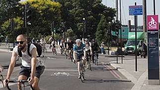
Cycle Superhighway 3 (CS3) is a long bike freeway in London, UK. It is part of the Cycle Superhighway network coordinated by TfL, running from Barking in the east to Lancaster Gate in central London.[1][2][3] It is part of the East-West Cycle Superhighway and is a popular route with both commuter and leisure cyclists, passing a number of major destinations in London en route.[1] For almost the entire route, cyclists are separated from other traffic in segregated cycle lanes, and cycling infrastructure has been provided at major interchanges.

Route
CS3 begins in Barking and ends at Lancaster Gate in the City of Westminster.[1][2]
Barking to Leamouth
CS3 begins to the south of Greatfields Park, Barking at the intersection between River Road and the A13 (Alfred's Way). The beginning of the Superhighway can be found at the southern side of the junction as a narrow, two-way cycle track signed "Cycle Superhighway (CS3)" towards Canning Town (25 mins), Canary Wharf (35 mins) and Tower Gateway (55 mins). The journey times are signposted and calculated by TfL.[4] The cycle track is coloured blue.
Heading westbound, the blue cycle track is intermittent, sharing its space with the pedestrian footpath. This continues for around 500 metres before the blue, two-way track returns as a constant feature running in parallel with the A13, separated from the main carriageway by a kerb.
CS3 and the A13 cross the Barking Creek alongside one another, at the same time crossing from Barking and Dagenham into Newham. After crossing Barking Creek, CS3 branches southwards so as to avoid clashing with traffic at the busy junction between the A13, the A406/North Circular and A1020.
Having passed beneath the A1020/Royal Docks Road, CS3 continues to run parallel to the A13 (Newham Way), segregated from traffic on the main carriageway.
The Superhighway passes through Beckton. There is short cycle link southwards towards Beckton DLR station.
CS3 passes to the east of Canning Town station, before running in parallel to the A13 once more to cross Bow Creek, which forms the boundary between Newham and Tower Hamlets.
Leamouth to Tower Gateway
To the west of Bow Creek, CS3 heads south of East India Dock Road (A13) into Leamouth on the western pavement of Leamouth Road. Still signposted but no longer a blue cycle track, CS3 then heads westbound on Sorrel Lane, southbound on Oregano Drive, then westbound on Saffron Avenue. Cyclists share road space with other traffic in this more residential area.
CS3 passes through Poplar, just north of Canary Wharf, sharing Poplar High Street with other road traffic. At the western end of Poplar High Street, the Superhighway continues along Ming Street and Premiere Place, passing Westferry DLR station to the north. Continuing westbound, CS3 follows Limehouse Causeway and Narrow Street, briefly running parallel to the River Thames.
Still signposted, CS3 then heads roughly north, joining Cable Street at its eastern terminus.
On Cable Street, the Superhighway is segregated from other road traffic on a narrow, two-way cycle track. CS3 is signposted and the track is painted blue. The Superhighway runs the entire length of Cable Street, passing both the Cable Street Mural and Shadwell DLR and London Overground stations.
CS3 leaves Tower Hamlets on Royal Mint Street, entering the City of London.
Tower Gateway to Lancaster Gate
The Superhighway crosses London's Inner Ring Road near Tower Gateway station. Tower Bridge and the Tower of London are visible to the south of CS3. Entering the City of London, CS3 is a wide cycle track segregated from other road traffic. This remains the case until CS3 reaches the Palace of Westminster.
In the City, the Superhighway avoids the busy centre, instead running in parallel to the Thames. Remaining segregated from other traffic, CS3 meets CS6 in a grade-separated junction at Blackfriars. At this point, the Superhighway crosses Victoria Embankment, following the Embankment until it reaches its southern terminus at the Palace of Westminster and Westminster Bridge. CS3 crosses the boundary between the City of London and the City of Westminster.
At the end of Victoria Embankment, CS3 heads westbound on Bridge Street, again as a wide, segregated cycle track, passing Parliament Square on its northernmost edge. CS3 then passes several government offices as it continues westbound, running along the entire length of Birdcage Walk (the southern boundary of St. James's Park).
CS3 then heads briefly north, passing Buckingham Palace, before continuing westbound again on Constitution Hill as a segregated bike freeway. The Superhighway then passes through the middle of Hyde Park Corner, sharing space with pedestrians.
Leaving Hyde Park Corner to the north, CS3 heads sharply westbound along a wide bike freeway which runs along the southern edge of Hyde Park (South Carriage Drive). At the end of the Drive, CS3 heads sharply northbound, following West Carriage Drive to its terminus at Lancaster Gate.
The beginning of CS3 at Lancaster Gate is signposted towards Hyde Park Corner (11 mins), Westminster (20 mins) and Kensington.
Destinations
Barking and Dagenham
Tower Hamlets
City of London
City of Westminster
- Temple station

- Embankment station
- Palace of Westminster and Big Ben
- Westminster station
- Parliament Square
- Churchill War Rooms
- HM Treasury
- St. James's Park
- Buckingham Palace
- Green Park
- Wellington Arch
- Hyde Park Corner
- Hyde Park Corner station
- Hyde Park
- Exhibition Road
- Serpentine Gallery
- Lancaster Gate
- Lancaster Gate station
History
Cycle Superhighway 3 (CS3) was originally proposed by former Mayor of London, Ken Livingstone. In 2008, Livingstone proposed a "cycling transformation in London," at the same time announcing the "biggest investment in cycling in London's history." CS3 was one of the original twelve "motorways of cycling," and was designed to take cyclists along the route it currently occupies from Barking to Lancaster Gate. It was thought that CS3 would then join up with two further superhighways - CS9 and CS10 - to extend the network in to West London.[5][6]
Cycle Superhighway 3 (CS3) was opened by Boris Johnson in Spring 2016. Johnson dubbed CS3 a "Crossrail for cyclists," hoping to create a "cleaner, safer, greener city."[7]
The extension from Westminster to Lancaster Gate opened in September 2018.[8]
References
- "East-West Cycle Superhighway (CS3) - Tower Hill to Lancaster Gate - Route alignment" (PDF). TfL. Archived from the original (PDF) on 28 March 2018.
- "OpenStreetMap - Relation: Cycle Superhighway 3 (1159230)". OpenStreetMap. 31 December 2018.
- "London Cycling Campaign". lcc.org.uk. Retrieved 2019-01-26.
- "Road Network Performance & Research - Traffic Note 11 - Cycle journey time reliability" (PDF). TfL. August 2009. Archived from the original (PDF) on 20 December 2015.
- Taylor, Matthew (2008-02-09). "City's two-wheel transformation". The Guardian. ISSN 0261-3077. Retrieved 2019-01-26.
- "I cycled the length of all London's Cycling Superhighways. Here's what I learnt | CityMetric". www.citymetric.com. Retrieved 2019-01-26.
- "Opening date announced for new £47m cycle superhighway". Evening Standard. 2016-03-07. Retrieved 2019-01-26.
- "Major new Cycle Superhighway extension opens in the heart of London". London City Hall. 2018-09-20. Retrieved 2019-01-26.