List of communities in Yukon
This is a list of communities in Yukon.
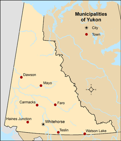
Municipalities
| Name | Status[1] | Official name | Incorporation date[2] | 2016 Census of Population[3] | ||||
|---|---|---|---|---|---|---|---|---|
| Population (2016) | Population (2011) | Change | Land area (km²) | Population density | ||||
| Carmacks | Town | Village of Carmacks | November 1, 1984 | 493 | 503 | −2.0% | 36.95 | 13.3/km2 |
| Dawson | Town | City of Dawson | January 9, 1902 | 1,375 | 1,319 | +4.2% | 32.45 | 42.4/km2 |
| Faro | Town | Town of Faro | June 13, 1969 | 348 | 344 | +1.2% | 203.57 | 1.7/km2 |
| Haines Junction | Town | Village of Haines Junction | October 1, 1984 | 613 | 593 | +3.4% | 34.49 | 17.8/km2 |
| Mayo | Town | Village of Mayo | June 1, 1984 | 200 | 226 | −11.5% | 1.06 | 188.7/km2 |
| Teslin | Town | Village of Teslin | August 1, 1984 | 124 | 122 | +1.6% | 1.92 | 64.6/km2 |
| Watson Lake | Town | Town of Watson Lake | April 1, 1984 | 790 | 802 | −1.5% | 6.11 | 129.3/km2 |
| Whitehorse | City | City of Whitehorse | June 1, 1950 | 25,085 | 23,276 | +7.8% | 416.54 | 60.2/km2 |
| Total municipalities | — | — | — | 29,028 | 27,185 | +6.8% | 733.09 | 39.6/km2 |
| Territory of Yukon | — | — | — | 35,874 | 33,897 | +5.8% | 474,712.68 | 0.08/km2 |
Unincorporated communities
Hamlets
Statistics Canada recognizes two census subdivisions in Yukon that are classified as hamlets.[4]
Localities
The Gazetteer of Yukon recognized 96 localities as of February 2012.[5] Two of these localities, Tagish and Upper Liard, are designated as census subdivisions by Statistics Canada, though are classified as settlements.[4]
- Aishihik
- Ballarat Creek
- Barlow
- Bear Creek
- Black Hills
- Boundary
- Braeburn
- Brewer Creek
- Britannia Creek
- Brooks Brook
- Calumet
- Canyon
- Canyon City
- Carcross Cutoff
- Caribou
- Champagne
- Clear Creek
- Clinton Creek
- Coffee Creek
- Conrad
- Dalton Post
- De Wette
- Dezadeash
- Dominion
- Eagle Plains
- Flat Creek
- Fort Reliance
- Fort Selkirk
- Forty Mile
- Frances Lake
- Glenboyle
- Gold Bottom
- Gold Run
- Gordon Landing
- Grand Forks
- Granville
- Gravel Lake
- Hootalinqua
- Isaac Creek
- Jakes Corner
- Jensen Creek
- Kirkman Creek
- Klondike
- Klukshu
- Koidern
- Kynocks
- Lansdowne
- Lapierre House
- Little Gold
- Little River
- Little Salmon
- Little Teslin Lake
- Lorne
- Mason Landing
- McCabe Creek
- McQuesten
- Minto
- Minto Bridge
- Montague
- Moosehide
- Morley River
- Nesketahin
- Ogilvie
- Paris
- Pelly Lakes
- Quill Creek
- Rancheria
- Readford
- Robinson
- Rock Creek
- Scroggie Creek
- Silver City
- Sixtymile
- Snag Junction
- Stevens Roadhouse
- Stony Creek Camp
- Sulphur
- Summit Roadhouse
- Tagish (also designated a census subdivision)[4]
- Takhini
- Takhini Hot Springs
- Ten Mile
- Teslin Crossing
- Teslin River
- Thistle Creek
- Tuchitua
- Upper Laberge
- Upper Liard (also designated a census subdivision)[4]
- Watson
- Wernecke
- West Dawson
- Whitefish Station
- Whitestone Village
- Yukon Crossing
Dalton Post
Dalton Post or Shäwshe is a former trading post and First Nations community on the Tatshenshini River. It was on the Dalton Trail near the Haines Highway. Today, it is a prime Pacific salmon fishing spot and serves as a base for whitewater rafting expeditions on the Tatshenshini and Alsek Rivers in the Tatshenshini-Alsek Provincial Park.
Jakes Corner
Jakes Corner is a spot on the road, at historical mile 866 of the Alaska Highway, at the junction with connections to the Tagish Road and the Atlin Road. There are a small number of area residents, the junction being best known for a gas station and café. The gas station has numerous examples of old machinery.
Klukshu
Klukshu's more recent history is as a seasonal aboriginal fishing community, benefitting from a large Chinook salmon run. Located near the Haines Highway, it has no permanent population. Interpretive information is provided by the Champagne and Aishihik First Nations.
Little Salmon
Little Salmon is located on the Robert Campbell Highway between Faro and Carmacks, and stretches along the lake of the same name and the Yukon River. The only non-residential establishment is the Yukon government highway maintenance camp at Drury Creek. It was formerly an important settlement of the Little Salmon/Carmacks First Nation.
Silver City
Silver City, a historic mining town, is today only the residence of a small number of people, one household being a bed and breakfast establishment. It is located at historical mile 1053 of the Alaska Highway.
Sulphur
Sulphur or Sulphur Creek was a mining camp south-east of Dawson on a creek of the same name that flows into the Indian River. A post office was opened there on 28 October 1903 by G. W. Coffin. It was closed in July 1922. The place is mentioned in Jack London's story, To Build a Fire.
Settlements
The Gazetteer of Yukon recognized 29 settlements as of February 2012.[5] Eleven of these settlements are designated as census subdivisions by Statistics Canada.[4]
- Arlington
- Armstrong
- Bear Creek
- Beaver Creek – also designated a census subdivision[4]
- Big Salmon
- Burwash Landing – also designated a census subdivision[4]
- Carcross – also designated a census subdivision[4]
- Destruction Bay – also designated a census subdivision[4]
- Dry Creek
- Dundalk
- Herschel
- Hundred Mile Landing
- Johnsons Crossing – also designated a census subdivision[4]
- Keno Hill – also designated a census subdivision[4]
- Lewis
- Livingstone
- Lower Laberge
- Marsh Lake
- Mendenhall Landing
- Old Crow – also designated a census subdivision[4]
- Pelly Crossing – also designated a census subdivision[4]
- Rampart House
- Ross River – also designated a census subdivision[4]
- Selwyn
- Snag
- Stewart Crossing – also designated a census subdivision[4]
- Stewart River
- Swift River – also designated a census subdivision[4]
- Teslin Lake
Herschel
Herschel was a settlement on Herschel Island, serving as a whaling station, North-West Mounted Police post and Hudson's Bay Company store. It has been long abandoned, and shoreline erosion is threatening to wipe out the remaining buildings.
Stewart River
Stewart River is a former settlement at the juncture of the Yukon and Stewart rivers. A few buildings and cabins remain, as well as private museum, which are threatened by erosion. It was founded as a trading post in the 1880s before the Klondike Gold Rush to serve placer miners working along the Stewart River. The Burian family was still living there in the late 1980s.
First Nations communities
Statistics Canada recognizes five census subdivisions in Yukon that are classified as Indian settlements,[4] and four census subdivisions as self-governments.[4]
Indian settlements
- Champagne – also recognized as a locality
- Kloo Lake
- Klukshu – also recognized as a locality
- Two Mile Village
- Two and One-Half Mile Village
Self-governments
- Carcross 4
- Lake Laberge 1
- Moosehide Creek 2
- Teslin Post 13
Ghost towns
- Elsa
- Clinton Creek
- Fort Frances
- Fortymile
- Miner's Prayer
Miner's Prayer
Miner's Prayer was settled near the Blackstone River Mining Concern, providing a retreat where the miners could indulge in billiards, alcohol and other entertainment otherwise forbidden on the mining settlement. Today it is home to fewer than thirty permanent residents. It can be accessed by gravel road veering west from mile 57 on the Dempster Highway.
References
- "Yukon Communities". Yukon Government: Department of Community Services. November 7, 2013. Archived from the original on January 16, 2014. Retrieved January 15, 2014.
- "Association of Yukon Communities Incorporation Dates". Association of Yukon Communities. Archived from the original on June 15, 2014. Retrieved June 14, 2014.
- "Population and dwelling counts, for Canada, provinces and territories, and census subdivisions (municipalities), 2016 and 2011 censuses – 100% data (Yukon)". Statistics Canada. February 8, 2017. Retrieved February 11, 2017.
- "Population and dwelling counts, for Canada, provinces and territories, and census subdivisions (municipalities), 2011 and 2006 censuses (Yukon)". Statistics Canada. January 13, 2014. Retrieved January 15, 2014.
- "Gazetteer of Yukon" (PDF) (PDF). Yukon Tourism and Culture. February 2012. pp. 6–74. Archived from the original (PDF) on March 31, 2014. Retrieved January 25, 2015.
- Robert G. Woodall, The Postal History of Yukon Territory Canada, Lawrence, MA, Quarterman, Revised edition, 1976, ISBN 0-88000-086-4
External links
- Yukon-Municipal Information
- Association of Yukon Communities
- Yukon Municipal Government Websites
- Yukon community profiles web site
| Provinces |
|
|---|---|
| Territories | |
| |
| Regions | |
|---|---|
| Municipalities | |
| Communities | |
| Ghost towns | |
| Parks | |
| |