List of World Heritage Sites in Mexico
The United Nations Educational, Scientific and Cultural Organization (UNESCO) World Heritage Sites are places of importance to cultural or natural heritage as described in the UNESCO World Heritage Convention, established in 1972.[1] Mexico accepted the convention on 23 February 1984, making its historical sites eligible for inclusion on the list. As of 2018, there are thirty-five World Heritage Sites in Mexico, including twenty-seven cultural sites, six natural sites and two mixed sites.[2] The country ranks first in the Americas and seventh worldwide by number of Heritage sites.

Mexico's first six sites, Sian Ka'an, Pre-Hispanic City and National Park of Palenque, Historic Centre of Mexico City and Xochimilco, Pre-Hispanic City of Teotihuacan, Historic Centre of Oaxaca and Archaeological site of Monte Albán, and Historic Centre of Puebla, were inscribed on the list at the 11th Session of the World Heritage Committee, held at UNESCO headquarters in Paris, France in 1987.[3]
In addition to its inscribed sites, Mexico also maintains twenty-one properties on its tentative list, considered for future nomination.[4]
There are also 9 traditions and celebrations which considered Intangible Cultural Heritage of Mexico: Indigenous festivals dedicated to the dead, The ceremony of the Flying Dancers, The Peña de Bernal, The traditional January party of Chiapa de Corzo, The traditional song of the P’urhépechas, Traditional Mexican cuisine, The Mariachi, The charrería and The pilgrimage of Zapopan.[5]
World Heritage Sites
- Site; named after the World Heritage Committee's official designation[6]
- Location; at city, regional, or provincial level and geocoordinates
- Criteria; as defined by the World Heritage Committee[7]
- Area; in hectares and acres. If available, the size of the buffer zone has been noted as well. A lack of value implies that no data has been published by UNESCO
- Year; during which the site was inscribed to the World Heritage List
- Description; brief information about the site, including reasons for qualifying as an endangered site, if applicable
| Site | Image | Location | Criteria | Area ha (acre) |
Year | Description |
|---|---|---|---|---|---|---|
| Historic Centre of Mexico City and Xochimilco | 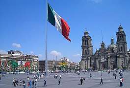 |
Mexico City 19°25′6″N 99°7′58″W |
Cultural: (ii)(iii)(iv)(v) |
— | 1987 | [8] |
| Historic Centre of Oaxaca and Archaeological site of Monte Albán | 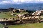 |
Oaxaca 17°3′43″N 96°43′18″W |
Cultural: (i)(ii)(iii)(iv) |
375 (930) | 1987 | Inhabited over a period of 1,500 years by a succession of peoples – Olmecs, Zapotecs and Mixtecs – the terraces, dams, canals, pyramids and artificial mounds of Monte Albán were literally carved out of the mountain and are the symbols of a sacred topography. The nearby city of Oaxaca, which is built on a grid pattern, is a good example of Spanish colonial town planning. The solidity and volume of the city's buildings show that they were adapted to the earthquake-prone region in which these architectural gems were constructed.[9] |
| Historic Centre of Puebla |  |
Puebla 19°2′50″N 98°12′13″W |
Cultural: (ii)(iv) |
690 (1,700) | 1987 | [10] |
| Pre-Hispanic City and National Park of Palenque | .jpg) |
Chiapas 17°29′0″N 92°3′0″W |
Cultural: (i)(ii)(iii)(iv) |
1,772 (4,380) | 1987 | A prime example of a Mayan sanctuary of the classical period, Palenque was at its height between AD 500 and 700, when its influence extended throughout the basin of the Usumacinta River. The elegance and craftsmanship of the buildings, as well as the lightness of the sculpted reliefs with their Mayan mythological themes, attest to the creative genius of this civilization.[11] |
| Pre-Hispanic City of Teotihuacán | 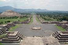 |
State of Mexico 19°41′30″N 98°50′30″W |
Cultural: (i)(ii)(iii)(iv) |
3,381.71 (8,356.4) | 1987 | [12] |
| Sian Ka'an |  |
Quintana Roo 19°23′0″N 87°47′30″W |
Natural: (vii)(x) |
528,000 (1,300,000) | 1987 | In the language of the Mayan peoples who once inhabited this region, Sian Ka'an means 'Origin of the Sky'. Located on the east coast of the Yucatán peninsula, this biosphere reserve contains tropical forests, mangroves and marshes, as well as a large marine section intersected by a barrier reef. It provides a habitat for a remarkably rich flora and a fauna comprising more than 300 species of birds, as well as a large number of the region's characteristic terrestrial vertebrates, which cohabit in the diverse environment formed by its complex hydrological system.[13] |
| Historic Town of Guanajuato and Adjacent Mines | .JPG) |
Guanajuato 21°1′1″N 101°15′20″W |
Cultural: (ii)(iv) |
2,167.5 (5,356) | 1988 | [14] |
| Pre-Hispanic City of Chichen-Itza | 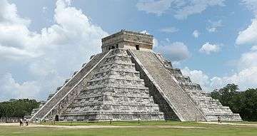 |
Yucatán 20°40′0″N 88°36′0″W |
Cultural: (i)(ii)(iii) |
— | 1988 | [15] |
| Historic Centre of Morelia |  |
Michoacán 19°42′16″N 101°11′30″W |
Cultural: (ii)(iv)(vi) |
390 (960) | 1991 | [16] |
| El Tajin, Pre-Hispanic City |  |
Papantla, Veracruz 20°26′47″N 97°22′38″W |
Cultural: (i)(ii)(iv) |
176.5 (436) | 1992 | Located in the state of Veracruz, El Tajin was at its height from the early 9th to the early 13th century. It became the most important centre in north-east Mesoamerica after the fall of the Teotihuacan Empire. Its cultural influence extended all along the Gulf and penetrated into the Maya region and the high plateaux of central Mexico. Its architecture, which is unique in Mesoamerica, is characterized by elaborate carved reliefs on the columns and frieze. The 'Pyramid of the Niches', a masterpiece of ancient Mexican and American architecture, reveals the astronomical and symbolic significance of the buildings. El Tajin has survived as an outstanding example of the grandeur and importance of the pre-Hispanic cultures of Mexico.[17] |
| Rock Paintings of the Sierra de San Francisco | 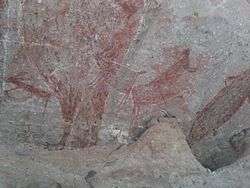 |
Baja California Sur 27°39′20″N 112°54′58″W |
Cultural: (i)(iii) |
182,600 (451,000) | 1993 | From c. 100 B.C. to A.D. 1300, the Sierra de San Francisco (in the El Vizcaino reserve, in Baja California) was home to a people who have now disappeared but who left one of the most outstanding collections of rock paintings in the world. They are remarkably well-preserved because of the dry climate and the inaccessibility of the site. Showing human figures and many animal species and illustrating the relationship between humans and their environment, the paintings reveal a highly sophisticated culture. Their composition and size, as well as the precision of the outlines and the variety of colours, but especially the number of sites, make this an impressive testimony to a unique artistic tradition.[18] |
| Whale Sanctuary of El Vizcaino |  |
Baja California Sur 27°47′32″N 114°13′40″W |
Natural: (x) |
369,631 (913,380) | 1993 | Located in the central part of the peninsula of Baja California, the sanctuary contains some exceptionally interesting ecosystems. The coastal lagoons of Ojo de Liebre and San Ignacio are important reproduction and wintering sites for the grey whale, harbour seal, California sea lion, northern elephant-seal and blue whale. The lagoons are also home to four species of the endangered marine turtle.[19] |
| Historic Centre of Zacatecas | 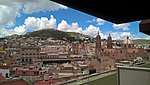 |
Zacatecas 22°46′0″N 102°33′20″W |
Cultural: (ii)(iv) |
207.72 (513.3) | 1993 | [20] |
| Earliest 16th-Century Monasteries on the Slopes of Popocatepetl |  |
Morelos and Puebla 18°56′5″N 98°53′52″W |
Cultural: (ii)(iv) |
— | 1994 | [21] |
| Historic Monuments Zone of Querétaro |  |
Querétaro 20°35′0″N 100°22′0″W |
Cultural: (ii)(iv) |
— | 1996 | [22] |
| Pre-Hispanic Town of Uxmal | .jpg) |
Yucatán 20°21′42″N 89°46′13″W |
Cultural: (i)(ii)(iii) |
— | 1996 | The Mayan town of Uxmal, in Yucatán, was founded c. A.D. 700 and had some 25,000 inhabitants. The layout of the buildings, which date from between 700 and 1000, reveals a knowledge of astronomy. The Pyramid of the Soothsayer, as the Spaniards called it, dominates the ceremonial centre, which has well-designed buildings decorated with a profusion of symbolic motifs and sculptures depicting Chaac, the god of rain. The ceremonial sites of Uxmal, Kabah, Labna and Sayil are considered the high points of Mayan art and architecture.[23] |
| Hospicio Cabañas, Guadalajara |  |
Jalisco 20°40′26″N 103°20′23″W |
Cultural: (i)(ii)(iii)(iv) |
— | 1997 | [24] |
| Historic Monuments Zone of Tlacotalpan |  |
Veracruz 18°36′30″N 95°39′30″W |
Cultural: (ii)(iv) |
75 (190) | 1998 | Tlacotalpan, a Spanish colonial river port on the Gulf coast of Mexico, was founded in the mid-16th century. It has preserved its original urban fabric to a remarkable degree, with wide streets, colonnaded houses in a profusion of styles and colours, and many mature trees in the public open spaces and private gardens.[25] |
| Archaeological Zone of Paquimé, Casas Grandes | 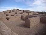 |
Chihuahua 30°22′33″N 107°57′20″W |
Cultural: (iii)(iv) |
146.72 (362.6) | 1998 | [26] |
| Historic Fortified Town of Campeche |  |
Campeche 19°50′47″N 90°32′14″W |
Cultural: (ii)(iv) |
181 (450) | 1999 | Campeche is a typical example of a harbour town from the Spanish colonial period in the New World. The historic centre has kept its outer walls and system of fortifications, designed to defend this Caribbean port against attacks from the sea.[27] |
| Archaeological Monuments Zone of Xochicalco |  |
Morelos 18°48′37″N 99°16′30″W |
Cultural: (iii)(iv) |
707.65 (1,748.6) | 1999 | [28] |
| Franciscan Missions in the Sierra Gorda of Querétaro | 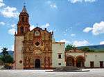 |
Querétaro de Arteaga 21°12′16″N 99°27′51″W |
Cultural: (ii)(iii) |
103.7 (256) | 2003 | [29] |
| Luis Barragán House and Studio | 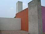 |
Mexico City 19°25′6″N 99°11′54″W |
Cultural: (i)(ii) |
0.1161 (0.287) | 2004 | Built in 1948, the House and Studio of architect Luis Barragán in the suburbs of Mexico City represents an outstanding example of the architect’s creative work in the post-Second World War period. The concrete building, totalling 1,161 m2, consists of a ground floor and two upper storeys, as well as a small private garden. Barragán’s work integrated modern and traditional artistic and vernacular currents and elements into a new synthesis, which has been greatly influential, especially in the contemporary design of gardens, plazas and landscapes.[30] |
| Islands and Protected Areas of the Gulf of California† |  |
Baja California, Baja California Sur, Sonora, Sinaloa and Nayarit 27°37′36″N 112°32′45″W |
Natural: (vii)(ix)(x) |
688,558 (1,701,460) | 2005 | [31][32] |
| Agave Landscape and Ancient Industrial Facilities of Tequila |  |
Jalisco 20°51′47″N 103°46′43″W |
Cultural: (ii)(iv)(v)(vi) |
35,018.852 (86,533.47) | 2006 | [33] |
| Central University City Campus of the Universidad Nacional Autónoma de México (UNAM) |  |
Mexico City 19°19′56″N 99°11′17″W |
Cultural: (i)(ii)(iv) |
176.5 (436) | 2007 | [34] |
| Monarch Butterfly Biosphere Reserve |  |
Michoacán and State of Mexico 19°36′23″N 100°14′30″W |
Natural: (vii) |
13,551.552 (33,486.61) | 2008 | [35] |
| Protective town of San Miguel de Allende and the Sanctuary of Jesús Nazareno de Atotonilco |  |
Guanajuato 20°54′52″N 100°44′47″W |
Cultural: (ii)(iv) |
46.95 (116.0) | 2008 | [36] |
| Camino Real de Tierra Adentro |  |
Various states 22°36′29″N 102°22′45″W |
Cultural: (ii)(iv) |
3,101.91 (7,665.0) | 2010 | Camino Real de Tierra Adentro was the Royal Inland Road, also known as the Silver Route. The inscribed property consists of 55 sites and five existing World Heritage sites lying along a 1400 km section of this 2600 km route, that extends north from Mexico City to Texas and New Mexico, United States of America. The route was actively used as a trade route for 300 years, from the mid-16th to the 19th centuries, mainly for transporting silver extracted from the mines of Zacatecas, Guanajuato and San Luis Potosí, and mercury imported from Europe. Although it is a route that was motivated and consolidated by the mining industry, it also fostered the creation of social, cultural and religious links in particular between Spanish and Amerindian cultures.[37] |
| Prehistoric Caves of Yagul and Mitla in the Central Valley of Oaxaca |  |
Oaxaca 16°57′3″N 96°25′16″W |
Cultural: (iii) |
1,515.17 (3,744.1) | 2010 | This property lies on the northern slopes of the Tlacolula valley in subtropical central Oaxaca and consists of two pre-Hispanic archaeological complexes and a series of pre-historic caves and rock shelters. Some of these shelters provide archaeological and rock-art evidence for the progress of nomadic hunter-gathers to incipient farmers. Ten thousand-year-old Cucurbitaceae seeds in one cave, Guilá Naquitz, are considered to be the earliest known evidence of domesticated plants in the continent, while corn cob fragments from the same cave are said to be the earliest documented evidence for the domestication of maize. The cultural landscape of the Prehistoric Caves of Yagul and Mitla demonstrates the link between man and nature that gave origin to the domestication of plants in North America, thus allowing the rise of Mesoamerican civilizations.[38] |
| El Pinacate and Gran Desierto de Altar Biosphere Reserve | 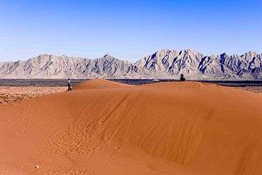 |
Sonora 32°0′0″N 113°55′0″W |
Natural: (vii)(viii)(x) |
714,566 (1,765,730) | 2013 | [39] |
| Ancient Maya City and Protected Tropical Forests of Calakmul, Campeche | 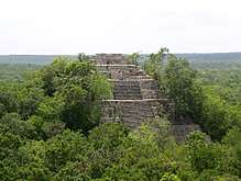 |
Campeche 18°3′11″N 89°44′14″W |
Mixed: (i)(ii)(iii)(iv)(ix)(x) |
331,397 (818,900) | 2014 | The site is located in the central/southern portion of the Yucatán Peninsula, in southern Mexico and includes the remains of the important Maya city Calakmul, set deep in the tropical forest of the Tierras Bajas. The city played a key role in the history of this region for more than twelve centuries and is characterized by well-preserved structures providing a vivid picture of life in an ancient Maya capital. The property also falls within the Mesoamerica biodiversity hotspot, the third largest in the world, encompassing all subtropical and tropical ecosystems from central Mexico to the Panama Canal.[40] |
| Aqueduct of Padre Tembleque Hydraulic System | 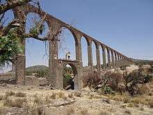 |
State of Mexico and Hidalgo 19°50′7″N 98°39′45″W |
Cultural: (i)(ii)(iv) |
6,540 (16,200) | 2015 | [41] |
| Revillagigedo Islands |  |
Colima 18°47′17″N 110°58′31″W |
Natural: (vii)(ix)(x) |
636,685.375 (1,573,283.82) | 2016 | [42] |
| Tehuacán-Cuicatlán Valley: originary habitat of Mesoamerica |  |
Puebla and Oaxaca 17°59′24″N 97°11′14″W |
Mixed: (iv)(x) |
145,255.2 (358,933) | 2018 | [43] |
Location of sites
Numbered sites: 1. Centro Histórico de la Ciudad de México; 2. Ciudad Universitaria; 3. Xochicalco; 4. Monasteries on the slopes of Popocatépetl; 5. Luis Barragan House and Studio; 6. Teotihuacan; 7. Monarch Butterfly Biosphere Reserve; 8. Aqueduct of Padre Tembleque
Legend: ![]()
![]()
![]()
Note: The Camino Real de Tierra Adentro inscribed property encompasses 59 cities, towns, bridges, haciendas and other monuments along some 1,400 km of the route. The point shown on the map is an approximate midpoint between historic Mexico City, the southernmost site, and the town of Valle de Allende, the most northern site. For a description and location of each site, see the UNESCO entry.
Tentative list
In addition to sites inscribed on the World Heritage list, member states can maintain a list of tentative sites that they may consider for nomination. Nominations for the World Heritage list are only accepted if the site was previously listed on the tentative list.[44] As of 2017, Mexico maintains twenty-one properties on its tentative list:[4]
- Chapultepec Woods, Hill and Castle (2001)
- Historic Town of Alamos (2001)
- Church of Santa Prisca and its Surroundings (2001)
- Pre-Hispanic City of Cantona (2001)
- Great City of Chicomostoc-La Quemada (2001)
- Historic Town of San Sebastián del Oeste (2001)
- Diego Rivera and Frida Kahlo's Home-Study Museum (2001)
- Valle de los Cirios (2004)
- Flora and Fauna Protection Area of Cuatro Ciénegas (2004)
- Historical Town The Royal of the Eleven Thousand Virgins of Cosala in Sinaloa (2004)
- Huichol Route through the sacred sites to Wirikuta (Tatehuari Huajuye) (2004)
- Lacan-Tún – Usumacinta Region (2004)
- Banco Chinchorro Biosphere Reserve (2004)
- Tecoaque (2004)
- Cuetzalan and its Historical, Cultural and Natural Surrounding (2006)
- Historical city of Izamal (Izamal, Mayan continuity in an Historical City) (2008)
- Los Petenes-Río Celestún (2008)
- Las Pozas, Xilitla (2008)
- Arch of Time of La Venta River (2010)
- Ring of cenotes of Chicxulub Crater, Yucatan (2012)
- Las Labradas, Sinaloa archaeological site (2012)
Pending transboundary nominations
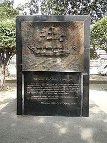
In 2014, the idea to nominate the Manila-Acapulco Galleon Trade Route was initiated by the Mexican ambassador to UNESCO with the Filipino ambassador to UNESCO.
An Experts' Roundtable Meeting was held at the University of Santo Tomas (UST) on April 23, 2015 as part of the preparation of the Philippines for the possible transnational nomination of the Manila-Acapulco Galleon Trade Route to the World Heritage List. The nomination will be made jointly with Mexico.
The following are the experts and the topics they discussed during the roundtable meeting: Dr. Celestina Boncan on the Tornaviaje; Dr. Mary Jane A. Bolunia on Shipyards in the Bicol Region; Mr. Sheldon Clyde Jago-on, Bobby Orillaneda, and Ligaya Lacsina on Underwater Archaeology; Dr. Leovino Garcia on Maps and Cartography; Fr. Rene Javellana, S.J. on Fortifications in the Philippines; Felice Sta. Maria on Food; Dr. Fernando Zialcita on Textile; and Regalado Trota Jose on Historical Dimension. The papers presented and discussed during the roundtable meeting will be synthesized into a working document to establish the route's Outstanding Universal Value.[45]
The Mexican side reiterated that they will also follow suit with the preparations for the route's nomination.
Spain has also backed the nomination of the route in the World Heritage List and has also suggested the archives related to the route under the possession of the Philippines, Mexico, and Spain to be nominated as part of another UNESCO list, the Memory of the World Register.[46]
In 2017, the Philippines established the Manila-Acapulco Galleon Museum in Metro Manila.[47]
| Type (criteria) | Site | Location | Description | Image | Ref |
|---|---|---|---|---|---|
| Mixed | The Historic Manila‑Acapulco Galleon Trade Route | Philippines and Mexico |  White represents the route of the Manila Galleons in the Pacific |
[45] |
References
- "The World Heritage Convention". UNESCO. Retrieved 21 September 2010.
- "Mexico". UNESCO. Retrieved 2 July 2018.
- "Report of the 11th Session of the Committee". UNESCO. Retrieved 16 July 2017.
- "Tentative List – Mexico". UNESCO. Retrieved 16 July 2017.
- "UNESCO World Heritage Sites in Mexico". "Mexican Routes [mexicanroutes.com]".
- "World Heritage List". UNESCO. Retrieved 28 May 2010.
- "The Criteria for Selection". UNESCO. Retrieved 10 September 2011.
- "Historic Centre of Mexico City and Xochimilco". UNESCO. Retrieved 16 July 2017.
- "Historic Centre of Oaxaca and Archaeological Site of Monte Albán". UNESCO. Retrieved 16 July 2017.

- "Historic Centre of Puebla". UNESCO. Retrieved 16 July 2017.
- "Pre-Hispanic City and National Park of Palenque". UNESCO. Retrieved 16 July 2017.
- "Pre-Hispanic City of Teotihuacan". UNESCO. Retrieved 16 July 2017.
- "Sian Ka'an". UNESCO. Retrieved 16 July 2017.
- "Historic Town of Guanajuato and Adjacent Mines". UNESCO. Retrieved 16 July 2017.
- "Pre-Hispanic City of Chichen-Itza". UNESCO. Retrieved 16 July 2017.
- "Historic Centre of Morelia". UNESCO. Retrieved 16 July 2017.
- "El Tajin, Pre-Hispanic City". UNESCO. Retrieved 16 July 2017.
- "Rock Paintings of the Sierra de San Francisco". UNESCO. Retrieved 16 July 2017.
- "Whale Sanctuary of El Vizcaino". UNESCO. Retrieved 16 July 2017.
- "Historic Centre of Zacatecas". UNESCO. Retrieved 16 July 2017.
- "Earliest 16th-Century Monasteries on the Slopes of Popocatepetl". UNESCO. Retrieved 16 July 2017.
- "Historic Monuments Zone of Querétaro". UNESCO. Retrieved 16 July 2017.
- "Pre-Hispanic Town of Uxmal". UNESCO. Retrieved 16 July 2017.
- "Hospicio Cabañas, Guadalajara". UNESCO. Retrieved 16 July 2017.
- "Historic Monuments Zone of Tlacotalpan". UNESCO. Retrieved 16 July 2017.
- "Archaeological Zone of Paquimé, Casas Grandes". UNESCO. Retrieved 16 July 2017.
- "Historic Fortified Town of Campeche". UNESCO. Retrieved 16 July 2017.
- "Archaeological Monuments Zone of Xochicalco". UNESCO. Retrieved 16 July 2017.
- "Franciscan Missions in the Sierra Gorda of Querétaro". UNESCO. Retrieved 16 July 2017.
- "Luis Barragán House and Studio". UNESCO. Retrieved 16 July 2017.
- "Islands and Protected Areas of the Gulf of California". UNESCO. Retrieved 16 July 2017.
- "The Islands and Protected Areas of the Gulf of California (Mexico) inscribed on the List of World Heritage in Danger". UNESCO. Retrieved 8 July 2019.
- "Agave Landscape and Ancient Industrial Facilities of Tequila". UNESCO. Retrieved 16 July 2017.
- "Central University City Campus of the Universidad Nacional Autónoma de México (UNAM)". UNESCO. Retrieved 16 July 2017.
- "Monarch Butterfly Biosphere Reserve". UNESCO. Retrieved 16 July 2017.
- "Protective town of San Miguel and the Sanctuary of Jesús Nazareno de Atotonilco". UNESCO. Retrieved 16 July 2017.
- "Camino Real de Tierra Adentro". UNESCO. Retrieved 16 July 2017.
- "Prehistoric Caves of Yagul and Mitla in the Central Valley of Oaxaca". UNESCO. Retrieved 16 July 2017.
- "El Pinacate and Gran Desierto de Altar Biosphere Reserve". UNESCO. Retrieved 16 July 2017.
- "Ancient Maya City and Protected Tropical Forests of Calakmul, Campeche". UNESCO. Retrieved 16 July 2017.
- "Aqueduct of Padre Tembleque Hydraulic System". UNESCO. Retrieved 16 July 2017.
- "Archipiélago de Revillagigedo". UNESCO. Retrieved 16 July 2017.
- "Tehuacán-Cuicatlán Valley: originary habitat of Mesoamerica". UNESCO. Retrieved 2 July 2018.
- "Tentative Lists". UNESCO. Retrieved 7 October 2010.
- "PH, Mexico push to nominate Manila-Acapulco Galleon Trade Route to World Heritage List". Official Gazette of the Republic of the Philippines. 28 April 2015. Retrieved 14 December 2017.

- "Archived copy". Archived from the original on 2017-12-14. Retrieved 2017-12-14.CS1 maint: archived copy as title (link)
- "Manila-Acapulco Galleon Museum rises in SM MOA - BusinessMirror". businessmirror.com.ph.
| North West |
| |
|---|---|---|
| North Central |
| |
| West |
| |
| East |
| |
| South West |
| |
| South Central |
| |
| South East |
| |
| ||
Lists of World Heritage Sites in the Americas | ||
|---|---|---|
| North America | ||
| Central America | ||
| The Caribbean |
| |
| South America | ||