List of earthquakes in Mexico
This is a partial list of earthquakes in Mexico. This list considers every notable earthquake felt or with its epicenter within Mexico's current borders and maritime areas.
Geology
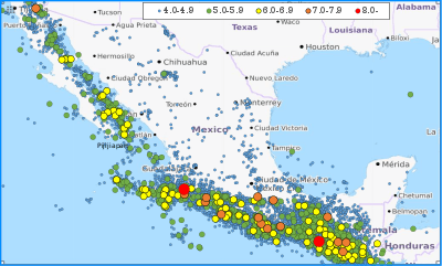
Mexico lies within two seismically active earthquake zones. The Baja California peninsula lies near the boundary of the Pacific Plate and the North American Plate, while southern Mexico lies just north of the boundary between the North American Plate and the Cocos and Rivera tectonic plates. The Cocos Plate is subducting under the North American Plate at a rate of 67 mm (0.220 ft) per year, while the Pacific and Rivera plates are moving northwest relative to the North American Plate. Southern Mexico also contains numerous faults, which causes that section of the country to have high tectonic activity. Northeastern Mexico and the Yucatan Peninsula are not as seismically active as the area close to the boundary between the North American and Cocos plates, but destructive earthquakes can still occur in those areas.
Earthquakes
| Date | Area | Mag. | MMI | Deaths | Injuries | Total damage / notes | |
|---|---|---|---|---|---|---|---|
| 2020-06-23 | Oaxaca | 7.4 Mw | VII | 10 | 25 | ||
| 2018-02-16 | Oaxaca | 7.2 Mw | VII | 14 | 17 | Most of casualties after a helicopter crash | |
| 2017-09-23 | Oaxaca | 6.1 Mw | VII | 6 | 7 | ||
| 2017-09-19 | Mexico City, Morelos, Puebla | 7.1 Mw | VIII | 370 | 6,011 | ||
| 2017-09-07 | Chiapas, Oaxaca | 8.2 Mw | IX | 98 | 300 | Tsunami | |
| 2015-10-23 | Guerrero | 5.5 Mw | IV | 2 | |||
| 2014-07-07 | Chiapas | 6.9 Mw | VIII | 5 | 12 | ||
| 2014-05-08 | Guerrero | 6.6 Mw | VII | ||||
| 2014-04-18 | Guerrero | 7.2 Mw | VII | 1 | |||
| 2012-03-20 | Guerrero, Oaxaca | 7.4 Mw | VII | 2 | 11 | ||
| 2011-12-10 | Guerrero | 6.5 Mw | VII | 3 | 10 | ||
| 2011-05-05 | Guerrero | 5.7 Mw | VI | ||||
| 2010-06-30 | Oaxaca | 6.2 Mw | 1 | ||||
| 2010-04-04 | Baja California | 7.2 Mw | VII | 2–4 | 100–233 | $1.15 billion | |
| 2009-04-27 | Guerrero | 5.8 Mw | V | 2 | |||
| 2003-01-22 | Colima | 7.5 Mw | VIII | 29 | 300 | Severe / tsunami | |
| 1999-09-30 | Oaxaca | 7.4 Mw | VIII | 35 | |||
| 1999-06-15 | Puebla | 7.0 Mw | 20 | MXN $200,000,000 | [1] | ||
| 1997-01-11 | Michoacán | 7.2 Mw | VIII | 1 | Damage at Arteaga | [2] | |
| 1995-10-21 | Chiapas | 7.1 Mw | VI | ||||
| 1995-10-09 | Colima, Jalisco | 8.0 Mw | VIII | 49–58 | 100 | Tsunami | |
| 1995-09-14 | Guerrero | 7.4 Mw | VII | 3 | |||
| 1985-09-19 | Michoacán, Mexico City | 8.0 Mw | IX | 5,000–45,000 | 30,000 | Extreme / tsunami | |
| 1981-10-25 | Michoacán | 7.2 Mw | 3 | ||||
| 1980-10-24 | Oaxaca | 7.2 Mw | IX | 65–300+ | Many | $5 million | |
| 1979-10-15 | Baja California | 6.4 Mw | IX | 91 | |||
| 1979-03-14 | Guerrero | 7.6 Mw | VIII | 5 | 35 | ||
| 1973-08-28 | Puebla, Veracruz | 7.0 ML | VIII | 539–1,000 | Thousands | Severe | |
| 1973-01-30 | Colima | 7.5 Ms | 56 | 390 | Moderate / non-destructive tsunami | NGDC | |
| 1968-08-02 | Guerrero, Oaxaca | 7.3 | VII | ||||
| 1965-08-23 | Oaxaca | 7.5 Mw | 6 | ||||
| 1964-07-06 | Guerrero | 7.4 Ms | IX | 40 | |||
| 1957-07-28 | Guerrero, Mexico City | 7.9 Ms | VII | 54–160 | Many | Extreme / tsunami | NGDC |
| 1941-04-15 | Colima | 7.6 Mw | IX | 90 | |||
| 1937-07-26 | Puebla, Veracruz | 7.3 Ms | IX | 34 | |||
| 1932-06-22 | Colima | 7.0 Mw | VIII | Tsunami | |||
| 1932-06-18 | Colima | 7.8 Mw | VIII | Tsunami | |||
| 1932-06-03 | Jalisco | 8.1 Mw | X | 400 | Tsunami | ||
| 1931-01-15 | Oaxaca | 7.8 Mw | X | 114 | |||
| 1920-01-03 | Puebla, Veracruz | 7.8 Ms | X–XII | 648–4,000 | 167 | NGDC | |
| 1912-11-19 | State of Mexico | 7.0[3] | VIII | ||||
| 1911-12-16 | Guerrero | 7.6 | IX | ||||
| 1911-06-07 | Michoacán | 7.6 | IX | 45 | |||
| 1909-07-30 | Guerrero | 7.6 | IX | ||||
| 1907-04-15 | Guerrero | 7.7 | VIII | ||||
| 1900-01-20 | Colima | 7.4 | VII | ||||
| 1899-01-24 | Guerrero | 7.5 | VII | ||||
| 1897-06-05 | Oaxaca | 7.4 | VII | ||||
| 1894-11-02 | Guerrero, Oaxaca | 7.4 | VIII | ||||
| 1892-02-24 | Baja California | 7.1–7.2 | X | 0 | |||
| 1890-12-02 | Guerrero, Oaxaca | 7.3 | VII | ||||
| 1889-09-06 | Guerrero | 7.1 | VI | ||||
| 1887-05-29 | Guerrero | 7.3 | VIII | ||||
| 1887-05-03 | Sonora | 7.6 Mw | 51 | ||||
| 1882-07-19 | Guerrero, Oaxaca | 7.5 | IX | ||||
| 1879-05-17 | Puebla | 7.1 | VIII | ||||
| 1875-03-09 | Colima, Jalisco | 7.4 | VII | ||||
| 1875-02-11 | Jalisco | 7.5 | VIII | ||||
| 1874-03-16 | Guerrero | 7.3 | VII | ||||
| 1872-03-27 | Oaxaca | 7.4 | VI | ||||
| 1870-05-11 | Oaxaca | 7.8 | IX | ||||
| 1864-10-03 | Puebla, Veracruz | 7.3 | VIII | ||||
| 1858-06-19 | Michoacán | 7.5 | IX | "Temblor de Santa Juliana" | [4] | ||
| 1854-05-05 | Oaxaca | 7.7 | VIII | ||||
| 1845-04-07 | Guerrero | 7.9 Ms | "Temblor de Santa Teresa" | [5][4] | |||
| 1852-11-29 | Baja California | 6.5 MLa | IX | [6] | |||
| 1845-03-09 | Oaxaca | 7.5 | VII | ||||
| 1837-11-22 | Jalisco | 7.7 | IX | ||||
| 1835-01-06 | State of Mexico | VII? | |||||
| 1820-05-04 | Guerrero | 7.6 | VII | ||||
| 1818-05-31 | Colima, Michoacán | 7.7 | VIII | ||||
| 1806-03-25 | Colima, Michoacán | 7.5 Ms | [5] | ||||
| 1800-03-08 | Central, Eastern, and Southeastern | VII | |||||
| 1787-03-28 | Guerrero, Oaxaca, Mexico City | 8.6 Mw | Severe / tsunami | ||||
| 1776-04-21 | Mexico City, Southern | VIII | |||||
| Stover & Coffman 1993 uses various seismic scales. MLa is a local magnitude that is equivalent to ML (Richter magnitude scale) and is used for events that occurred prior to the instrumental period. It is based on the area of perceptibility (as presented on isoseismal maps). Mw = moment magnitude scale and Ms = surface wave magnitude. The inclusion criteria for adding events are based on WikiProject Earthquakes' notability guideline that was developed for stand alone articles. The principles described are also applicable to lists. In summary, only damaging, injurious, or deadly events should be recorded. | |||||||
See also
Notes
- "Puebla, a 18 años del terremoto de 1999" [Puebla, 18 years after the earthquake of 1999]. El Popular (in Spanish). June 15, 2016.
- USGS. "M 7.2 - Michoacan, Mexico". United States Geological Survey.
- http://www.geociencias.unam.mx/~ger/2003_Tectonophisics_Qro.pdf
- "19th century earthquakes in Mexico: three cases, three comparative studies" by América Molina del Villar
- Singh, S. K.; Astiz, L.; Havskov, J. (1981), "Seismic gaps and recurrence periods of large earthquakes along the Mexican subduction zone: A reexamination", Bulletin of the Seismological Society of America, Seismological Society of America, 71 (3): 828
- Stover, C. W.; Coffman, J. L. (1993), Seismicity of the United States, 1568–1989 (Revised), U.S. Geological Survey Professional Paper 1527, United States Government Printing Office, pp. 72, 101
References
- NGDC (1972), Significant Earthquake Database (Data Set), National Geophysical Data Center, NOAA, doi:10.7289/V5TD9V7K