Linthicum Heights Historic District
Linthicum Heights Historic District is a national historic district at Linthicum Heights, Anne Arundel County, Maryland. It consists of a suburban community surrounding the intersection of Camp Meade Road (MD 170) and Maple Road. The community is situated on a series of low hills about three miles south of the Patapsco River and includes 17 tree-shaded streets created originally as a planned railroad suburb on the lines connecting Baltimore, Annapolis, and Washington, beginning in 1908. The district consists of 254 contributing resources, including two churches, a cemetery, and a former commercial/residential building. Most of the housing was built prior to 1939 and include examples of the Bungalow, American Foursquare, Colonial Revival, Dutch Revival, and Tudor Revival styles.[2]
Linthicum Heights Historic District | |
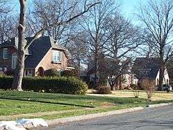 Streetscape in Linthicum Heights Historic District, December 2009 | |
  | |
| Nearest city | Linthicum, Maryland |
|---|---|
| Coordinates | 39°12′22″N 76°39′17″W |
| Area | 166 acres (67 ha) |
| Built | 1908 |
| Architectural style | Bungalow/Craftsman, Late 19th And 20th Century Revivals |
| NRHP reference No. | 06000451[1] |
| Added to NRHP | May 31, 2006 |
It was listed on the National Register of Historic Places in 2006.[1]
Gallery
 Streetscape in Linthicum Heights Historic District, December 2009
References
- "National Register Information System". National Register of Historic Places. National Park Service. March 13, 2009.
- Beth P. Nowell (July 2005). "National Register of Historic Places Registration: Linthicum Heights Historic District" (PDF). Maryland Historical Trust. Retrieved 2016-01-01.
External links
- Linthicum Heights Historic District, Anne Arundel County, including photo from 2005, at Maryland Historical Trust
- Where We Live: A Small Town Few Want to Leave, Though Near BWI Linthicum Has a Neighborhood Feel, The Washington Post, July 11, 2009.
| Topics |  | |
|---|---|---|
| Lists by county | ||
| Lists by city | ||
| Other lists | ||
| ||