Limpopo
Limpopo is the northernmost province of South Africa. It is named after the Limpopo River, which forms the province's western and northern borders.[4] The capital and largest city in the province is Polokwane (formerly Pietersburg).
Limpopo | |
|---|---|
 Coat of arms | |
| Motto(s): Peace, Unity and Prosperity | |
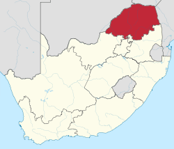 Location of Limpopo in South Africa | |
| Country | South Africa |
| Established | 27 April 1994 |
| Capital | Polokwane |
| Districts | |
| Government | |
| • Type | Parliamentary system |
| • Premier | Stanley Mathabatha (ANC) |
| • Legislature | Limpopo Provincial Legislature |
| Area [1]:9 | |
| • Total | 125,754 km2 (48,554 sq mi) |
| Area rank | 5th in South Africa |
| Highest elevation | 2,126 m (6,975 ft) |
| Population | |
| • Total | 5,404,868 |
| • Estimate (2019) | 5,982,584 |
| • Rank | 5th in South Africa |
| • Density | 43/km2 (110/sq mi) |
| • Density rank | 5th in South Africa |
| Population groups [1]:21 | |
| • Black | 96.7% |
| • White | 2.6% |
| • Indian or Asian | 0.3% |
| • Coloured | 0.3% |
| Languages [1]:25 | |
| • Northern Sotho | 52.9% |
| • Tsonga | 17.0% |
| • Venda | 16.7% |
| • Afrikaans | 2.6% |
| • Tswana | 2.0% |
| • Southern Ndebele | 2.0% |
| Time zone | UTC+2 (SAST) |
| ISO 3166 code | ZA-LP |
| HDI (2018) | 0.705[3] high · 4th |
| Website | www.limpopo.gov.za |
The province was formed from the northern region of Transvaal Province in 1994, and was initially named Northern Transvaal. The following year, it was renamed Northern Province, which remained the name until 2003, when it was formally changed to Limpopo after deliberation by the provincial government and amendment of the South African Constitution. An alternate name considered for the province was Mapungubwe.
Traditional leaders and chiefs still form a strong backbone of the province’s political landscape. Established in terms of the Limpopo House of Traditional Leaders Act, Act 5 of 2005, the Limpopo House of Traditional Leaders’ main function is to advise government and the legislature on matters related to custom, tradition and culture including developmental initiatives that have an impact on rural communities. On 18 August 2017 Kgosi Malesela Dikgale was re-elected as the Chairperson of the Limpopo House of Traditional Leaders.
The Zion Christian Church (or ZCC) is the largest African initiated church operating across Southern Africa. The church's headquarters are at Zion City Moria in Limpopo Province, South Africa (Northern Transvaal). The church was founded by Engenas Lekganyane in 1910 in his home village of Thabakgone, near Polokwane (Pietersburg).
According to the 1996 South African Census, the church numbered 3.87 million members. By the 2001 South African Census, its membership had increased to 4.97 million members. The final number of ZCC members is most likely between 8 and 10 million, in total, according to figures provided by Neal Collins from The New Age and Alex Matlala from The Citizen, two South African newspapers.
Geography
Limpopo Province shares international borders with districts and provinces of three countries: Botswana's Central and Kgatleng districts to the west and northwest respectively, Zimbabwe's Matabeleland South and Masvingo provinces to the north and northeast respectively, and Mozambique's Gaza Province to the east.[5] Limpopo is the link between South Africa and countries further afield in sub-Saharan Africa. On its southern edge, from east to west, it shares borders with the South African provinces of Mpumalanga, Gauteng, and North West. Its border with Gauteng includes that province's Johannesburg-Pretoria axis, the most industrialised metropolis on the continent. The province is at the centre of regional, national, and international developing markets.
Limpopo contains much of the Waterberg Biosphere, a massif of approximately 15,000 km2 (5,800 sq mi) which is the first region in the northern part of South Africa to be named a UNESCO Biosphere Reserve.[6]
Law and government
The current Premier of Limpopo Province is Stanley Mathabatha, representing the African National Congress.
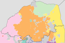
Municipalities
.svg.png)
Limpopo Province is divided into five district municipalities. The district municipalities are in turn divided into 25 local municipalities:
District municipalities
- Capricorn District
- Mopani District
- Sekhukhune District
- Elias Motsoaledi
- Ephraim Mogale
- Fetakgomo/Greater Tubatse
- Makhuduthamaga
- Vhembe District
- Waterberg District
- Bela-Bela
- Lephalale
- Modimolle/Mookgopong
- Mogalakwena
- Thabazimbi
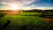
Economy
.jpg)
The province is a typical developing area, exporting primary products and importing manufactured goods and services. It is also one of the poorest regions of South Africa with a big gap between poor and rich residents, especially in rural areas.[7]
Agriculture
The bushveld is beef cattle country, where extensive ranching operations are often supplemented by controlled hunting. About 80% of South Africa's game hunting industry is found in Limpopo.
Sunflowers, cotton, maize and peanuts are cultivated in the Bela-Bela and Modimolle areas. Modimolle is also known for its table grapes. Tropical fruit, such as bananas, litchis, pineapples, mangoes and pawpaws, as well as a variety of nuts, are grown in the Tzaneen and Louis Trichardt areas. Tzaneen is also at the centre of extensive citrus, tea and coffee plantations, and a major forestry industry. Most of the farmers and house holds suffer from water supply, therefore they drill their boreholes in their premises.
Mining
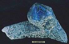
Limpopo's rich mineral deposits include the platinum group metals, iron ore, chromium, high- and middle-grade coking coal, diamonds, antimony, phosphate, and copper, as well as mineral reserves like gold, emeralds, scheelite, magnetite, vermiculite, silicon, and mica. Commodities such as black granite, corundum, and feldspar are also found. Mining contributes to over a fifth of the provincial economy.
Limpopo has the largest platinum deposit in South Africa. The Waterberg Coalfield, the eastern extension of Botswana's Mmamabula coalfields, is estimated to contain 40% of South Africa's coal reserves.[8]
Tourism
Near Modjadjiskloof, at Sunland Baobab farms, there is a large Baobab tree which has been fashioned into a rather spacious pub.[9]
The Limpopo Department of Economic Development, Environment and Tourism has targeted the province as a preferred eco-tourism destination. Its Environment and Tourism Programme encompasses tourism, protected areas and community environment development to achieve sustainable economic growth.[10]
While Limpopo is one of South Africa's poorest provinces, it is rich in wildlife, which gives it an edge in attracting tourists. Both the private and public sectors are investing in tourism development.
Transportation and communications
The province has excellent road, rail, and air links. The N1 route from Johannesburg, which extends the length of the province, is the busiest overland route in Africa in terms of cross-border trade in raw materials and beneficiated goods. The port of Durban, South Africa’s busiest, is served directly by the province, as are the ports of Richards Bay and Maputo. Polokwane International Airport is situated just north of Polokwane.
Education
The Department of Education is charged with the responsibility of effecting quality education and training for all. The Department has to coordinate all professional development and support. Policies, systems, and procedures had to be developed.
Educational institutions
- University of Limpopo (Polokwane, Mankweng)
- University of Venda (Thohoyandou)
- Capricon College for TVET (Polokwane)[11]
- Lephalale TVET College (Lephalale)[12]
- Letaba TVET College (Tzaneen)[13]
- Mopani South East TVET College (Phalaborwa)[14]
- Sekhukhune TVET College (Motetema)[15]
- Vhembe TVET College (Venda)[16]
- Waterberg TVET College (Mokopane)[17]
Sports
- Association football: Polokwane was one of South Africa's host cities for the 2010 FIFA World Cup, with matches being played at the Peter Mokaba Stadium. Football clubs in the province include Real Rovers, Silver Stars, Back Leopards, Polokwane City, Baroka, Ria Stars, and Dinamos.
- Rugby union: Limpopo has no provincial rugby team of its own; it is represented in the domestic Currie Cup by the Pretoria-based Blue Bulls. The Blue Bulls also operate a Super Rugby franchise, known simply as the Bulls. Limpopo nonetheless produces its share of top players. Most notably, the two most-capped forwards in the history of the country's national team, John Smit and Victor Matfield, are both natives of Polokwane.
- Basketball: The province is home to Limpopo Pride, a professional team that plays in South Africa's top basketball division, the Basketball National League.
Demographics
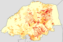
|
< 1 /km²
1–3 /km²
3–10 /km²
10–30 /km²
30–100 /km² |
100–300 /km²
300–1000 /km²
1000–3000 /km²
> 3000 /km² |
|
Afrikaans
Swati |
No language dominant |
The population of Limpopo consists of several ethnic groups distinguished by culture, language and race. 97.3% of the population is Black, 2.4% is White, 0.2% is Coloured, and 0.1% is Indian/Asian. The province has the smallest percentage and second smallest total number of white South Africans in the country. It also has the highest Black percentage out of all the provinces.
The Northern Sotho people make up the largest percentage of the population, making 52% of the province. The Tsonga people comprise about 24.0% of the province; the Tsonga also comprise about 11.5% of Mpumalanga province since the southern part of their homeland, Gazankulu, was cut off from Limpopo and allocated to Mpumalanga. The Venda make up about 16.7%. Afrikaners make up the majority of Limpopo's white population, about 95,000 people; English-speaking whites number just over 20,000. Vhembe district has the smallest share of white people in Limpopo, about 5,000 total, while the Waterberg district has the largest share of whites, with more than 60,000 whites residing there. Coloureds and Asians/Indians make up a very small percentage of the province's total population.
See also
References
- Census 2011: Census in brief (PDF). Pretoria: Statistics South Africa. 2012. ISBN 9780621413885. Archived (PDF) from the original on 13 May 2015.
- Mid-year population estimates, 2019 (PDF) (Report). Statistics South Africa. 31 July 2019. p. 3. Retrieved 31 December 2019.
- "Sub-national HDI - Area Database - Global Data Lab". hdi.globaldatalab.org. Retrieved 13 September 2018.
- "Limpopo Province - An Overview". dolimpopo.com. Archived from the original on 1 February 2017. Retrieved 20 January 2017.
- "Minister Dlamini to conduct two day Ministerial visit in Vhembe". Limpopo.gov.za. Retrieved 21 December 2017.
- C.Michael Hogan, Mark L. Cooke and Helen Murray, The Waterberg Biosphere, Lumina Technologies, 22 May 2006. "Archived copy". Archived from the original on 24 March 2007. Retrieved 23 December 2006.CS1 maint: archived copy as title (link)
- Archived 8 June 2011 at the Wayback Machine
- "Mmamabula Coalfield". Cicenergycorp.com. February 2012. Archived from the original on 6 November 2010. Retrieved 21 September 2012.CS1 maint: ref=harv (link)
- "The Big Baobab Limpopo South Africa | The Largest Baobab in the World". Bigbaobab.co.za. 24 March 2011. Archived from the original on 15 September 2019. Retrieved 2 August 2014.
- https://www.govpage.co.za/capricorn-tvet-college.html
- https://www.govpage.co.za/lephalale-tvet-college.html
- https://www.govpage.co.za/letaba-tvet-college.html
- https://www.govpage.co.za/mopani-south-east-tvet-college.html
- https://www.govpage.co.za/sekhukhune-tvet-college.html
- https://www.govpage.co.za/vhembe-tvet-college.html
- https://www.govpage.co.za/waterberg-tvet-college.html
- "HIV and AIDS in South Africa". Avert.org. 21 July 2015. Retrieved 21 December 2017.
External links
| Wikivoyage has a travel guide for Limpopo. |
| Wikimedia Commons has media related to Limpopo. |
| |||||||
| Provinces | |||||||
| Municipalities |
| ||||||
| Settlements |
| ||||||