Tzaneen
Tzaneen is a large tropical garden town situated in the Mopani District Municipality of the Limpopo province in South Africa. It is situated in a high rainfall fertile region with tropical and subtropical agriculture taking place in a 20,000 km2 region. It is Limpopo's second largest town after Polokwane.
Tzaneen Tsaneng | |
|---|---|
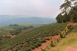 Tea and more plantation in Tzaneen | |
 Tzaneen  Tzaneen  Tzaneen | |
| Coordinates: 23°50′S 30°10′E | |
| Country | South Africa |
| Province | Limpopo |
| District | Mopani |
| Municipality | Greater Tzaneen |
| • Councillor | (ANC) |
| Area | |
| • Total | 22.16 km2 (8.56 sq mi) |
| Elevation | 719 m (2,359 ft) |
| Population (2011)[1] | |
| • Total | 14,571 |
| • Density | 660/km2 (1,700/sq mi) |
| Racial makeup (2011) | |
| • Black African | 65.0% |
| • Coloured | 1.1% |
| • Indian/Asian | 7.0% |
| • White | 26.1% |
| • Other | 0.9% |
| First languages (2011) | |
| • Afrikaans | 2.6% |
| • Northern Sotho | 46.2% |
| • Tsonga | 44.5% |
| • English | 1.6% |
| • Other | 8.5% |
| Time zone | UTC+2 (SAST) |
| Postal code (street) | 0850 |
| PO box | 0850 |
| Area code | 015 |
About 475,000 people reside within a 30 km radius, with the town itself holding a population of around 30,000. Tzaneen is today a proud home of both the Tsonga people and Northern Sotho tribes. Approximately 225 000 Northern Sotho of BaLobedu, BaNareng, Batlou, Bathlabin and BaKgaga calls Tzaneen their home. Equally so, approximately 220 000 Tsonga people of Shiluvane-Nkuna clan under Hosi Muhlaba-Shiluvane (132 000 people/subjects) and Valoyi clan under Hosi Nwamitwa-Valoyi (91 000 people/subjects) makes the same claim that Tzaneen is also their native land, thereby making the Tsonga-Sotho ratio at Tzaneen a 50:50 outcome. Both the Tsonga and the Northern Sotho communities goes beyond Tzaneen and are also found in large numbers in nearby towns of Bushbuckridge and Hazyview respectively, which are 191 km south-east of Tzaneen and they also live peacefully with one another in this part of the lowveld. The White population is around 25 000, which consists mainly the Afrikaner people and a very small minority of English, Portuguese, Scottish, Irish, Jewish and German. The Afrikaner people constitute more than 90% of the white population in Tzaneen. The distance from Tzaneen to Johannesburg is approximately 420 km, or 261 miles.
Origin of the name
Tzaneen corrupted name is derived from a Northern Sotho word 'Tsaneng', which means gathering place or 'Tsana' (basket of hills). This theory claim that Makgoba, the leader of a small Tlou tribe, gave the name 'Tsaneng' to the place where the town of Tzaneen is situated today. Since then, this Northern Sotho word has been widely used by the Northern Sotho people of the area to refer to the name of this place and was adopted by Afrikaners as Tzaneen.
Nonetheless, the name 'Tzaneen' appropriated by the Afrikaner people, from the Tlou people, under Makgoba, rightfully named the place 'Tsaneng' because it is today a place where Northern Sotho, Tsonga, Afrikaner, English and other people 'gather', thus fulfilling the name.
Geology and geography
Tzaneen is Limpopo's paradise and it has been nicknamed 'Land of Silver Mist' because of the frequent mist that occur on the mountains above it. It is located in lush, tropical surroundings and is home to Limpopo's highest mountain, the Iron Crown Mountain, lying more than 2200 m above sea level. The Iron Crown mountain, also known by its Afrikaans name Wolkberg, supports Limpopo's biodiversity and is home to South Africa's second largest indigenous forest after Tsitsikamma forest in the southern Cape. Weather can change very fast from clear skies to being misty, with the highest reaches enveloped in clouds. Hence the name of the range, meaning "Cloud Mountain" in Afrikaans. The Wolkberg is rugged, with rocky shoulders and deep humid gorges. There are rare plant and animal species in these areas. Species such as the Wolkberg Zulu (Alaena margaritacea), the Wolkberg widow (Dingana clara) and the Wolkberg sandman (Spialia secessus), have been named after these mountains. The Wolkberg area is one of only two areas in the world where the critically endangered butterfly, Lepidochrysops lotana, are found.[2][3] The Iron Crown Mountain is a protected area in terms of South African law. The Groot Letaba River, Middle Letaba River and Klein Letaba River all rise up in these mountains.
Agriculture
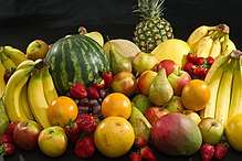
Tzaneen produces about 40% of South Africa's avocados, 40% of South Africa's mangoes and 20% of South Africa's bananas. Tzaneen also produces 90% of South Africa's tomatoes through the ZZ2, and other, farms making South Africa the world's 40th largest tomato producer. Even though South Africa is ranked 40th in terms of tomato production, the ZZ2 farms themselves are the world's biggest producer of tomatoes. Tzaneen is also the biggest producer of pine plantations in the Limpopo Province, accounting for more than 85% of Limpopo's pine and bluegum production. The majority of Tzaneen's tropical indigenous forest have been destroyed during the last 100-years in order to give way to pine, bluegum and other agricultural plantations.
The economy of Tzaneen depends largely on farming fruits, vegetables, animals and timber. Agriculture was the key development in the rise of Tzaneen, whereby farming of domesticated species created food surpluses that nurtured its development. Water boreholes are common in Tzaneen farms and households as a means to water crops and for household chores.
A wide range of fruit are grown in the Tzaneen area, notably mangoes, bananas, oranges, tomatoes and avocados. Pine and eucalyptus plantations are also a common sight in the area around the town, particularly toward Modjadjiskloof, Magoebaskloof and Haenertsburg. The plantations serve a number of sawmills located in the area.
Education
Tzaneen branch is charged with the responsibility of effecting quality education and training for all. It was during this time that the branch had to shape up its direction and co-ordinate all professional developments and support. Policies, systems, and procedures had to be developed. This was not easily achievable due to lack of personnel to effect change. Tzaneen still remains as one of the areas in South Africa with a high rate of tertiary graduates but a low employment rate.
Sports
Soccer and rugby are the main loved sports in Tzaneen. Soccer is widely played in the rural areas and townships.
Tourism
Tourism is also an important part of the Tzaneen economy, along with agribusiness. Tzaneen offers great country and town accommodation for visitors.
There are many tourist attractions around the small town of Tzaneen, including the beautiful Tzaneen Dam, Magoebaskloof, Haenertsburg and Wolkberg mountains. The town is also situated close to a number of game reserves and the town often serves as a thoroughfare for tourists on their way to other tourist destinations in the province. The well-known Kruger National Park, for instance, is situated approximately 100 km (62 miles) away.
The Vervet Monkey Foundation is located just outside Tzaneen where it cares for over 600 vervet monkeys.
Weather
Mostly sunshine, long summer days with pleasant winters. Tzaneen's subtropical conditions provide more suited weather for dense forests (high summer rainfall) than the thorny bushveld above the escarpment and further to the east.
The summer months, September – March, have an average temperature of 28 °C (82 °F) and winter months around 15 °C (59 °F). Rainfall averages from around 800 mm per year in town to over 1500 mm per year in the mountains.
Notable people
- Tito Mboweni (born 1959), businessman, economist and former central banker
- Marchant de Lange (born 1990), international cricketer[4]
- Mahlatse "Chiliboy" Ralepelle (born 1986), rugby player
- Trevor Nyakane Springbok rugby player
- Judas Moseamedi current PSL player
- Andrew Rabutla former Jomo Cosmos player
- Ernst Roets (born 1985) Deputy head of AfriForum
References
- "Main Place Tzaneen". Census 2011.
- Woodhall, Steve (2005). Field Guide to Butterflies of South Africa. Cape Town, South Africa: Struik. ISBN 978-1-86872-724-7.
- "The Beauty of Butterflies and Moths of South Africa".
- "Marchant de Lange". Cricinfo. Retrieved 2018-06-19.
External links
| Wikimedia Commons has media related to Tzaneen. |
| Wikivoyage has a travel guide for Tzaneen. |
- Tzaneen Business, Community & Tourism Site Tzaneen Business, Community & Information Gateway - www.tzaneeninfo.com
- Tzaneen Travel / Business Directory Comprehensive Tzaneen Travel Directory
- Tzaneen Country Club Tzaneen Golf Course
- More about Tzaneen
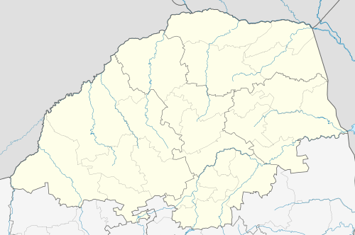
- Municipal Demarcation Board: Map of the Mopani District Municipality
- Government website
Municipalities and communities of Mopani District Municipality, Limpopo | ||
|---|---|---|
District seat: Giyani | ||
| Ba-Phalaborwa | .svg.png) | |
| Greater Giyani | ||
| Greater Letaba | ||
| Greater Tzaneen | ||
| Maruleng | ||