Free State (province)
The Free State (Sotho: Freistata; Afrikaans: Vrystaat; Xhosa: iFreyistata; Tswana: Foreistata; Zulu: iFuleyisitata; before 1995, the Orange Free State) is a province of South Africa. Its capital is Bloemfontein, which is also South Africa's judicial capital. Its historical origins lie in the Boer republic called the Orange Free State and later Orange Free State Province.
Free State Freistata (in Sotho) Vrystaat (in Afrikaans) iFreyistata (in Xhosa) Foreistata (in Tswana) iFuleyisitata (in Zulu) | |
|---|---|
 Coat of arms | |
| Motto(s): Katleho ka kopano (Success through unity) | |
 Location of the Free State in South Africa | |
| Coordinates: 28°S 27°E | |
| Country | South Africa |
| Orange Free State | 17 February 1854 |
| OFS Province | 31 May 1910 |
| Free State | 27 April 1994 |
| Capital | Bloemfontein |
| Districts | |
| Government | |
| • Type | Parliamentary system |
| • Premier | Sisi Ntombela (ANC) |
| • Legislature | Free State Provincial Legislature |
| Area [1]:9 | |
| • Total | 129,825 km2 (50,126 sq mi) |
| Area rank | 3rd in South Africa |
| Highest elevation | 3,291 m (10,797 ft) |
| Population | |
| • Total | 2,745,590 |
| • Estimate (2019) | 2,887,465 |
| • Rank | 8th in South Africa |
| • Density | 21/km2 (55/sq mi) |
| • Density rank | 8th in South Africa |
| Population groups [1]:21 | |
| • Black | 88.7% |
| • White | 8.9% |
| • Coloured | 1.8% |
| • Indian or Asian | 0.6% |
| Languages [1]:25 | |
| • Sotho | 64.2% |
| • Afrikaans | 12.7% |
| • Xhosa | 7.5% |
| • Tswana | 5.2% |
| • Zulu | 4.4% |
| • English | 2.9% |
| Time zone | UTC+2 (SAST) |
| ISO 3166 code | ZA-FS |
| HDI (2018) | 0.705[4] high · 3rd |
| Website | www |
History
The current borders of the province date from 1994 when the Bantustans were abolished and reincorporated into South Africa. It is also the only one of the four original provinces of South Africa not to undergo border changes, apart from the reincorporation of Bantustans, and has had these borders since before the outbreak of the Boer War.
Law and government
The provincial government consists of a premier, an executive council of ten ministers, and a legislature. The provincial assembly and premier are elected for five-year terms, or until the next national election. Political parties are awarded assembly seats based on the percentage of votes each party receives in the province during the national elections. The assembly elects a premier, who then appoints the members of the executive council.
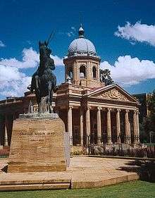
The provincial legislature meets at the Vierde Raadsaal in Bloemfontein. The premier of Free State is Sisi Ntombela. She has been serving since her appointment in March 2018.[5]
Geography

The Free State is situated on a succession of flat grassy plains sprinkled with pastureland, resting on a general elevation of 3,800 feet only broken by the occasional hill or kopje. The rich soil and pleasant climate allow for a thriving agricultural industry. With more than 30,000 farms, which produce over 70% of the country's grain, it is known locally as South Africa's breadbasket.
The province is high-lying, with almost all land being 1,000 metres above sea level. The Drakensberg and Maluti Mountains foothills raise the terrain to over 2,000 m in the east. The Free State lies in the heart of the Karoo Sequence of rocks, containing shales, mudstones, sandstones and the Drakensberg Basalt forming the youngest capping rocks. Mineral deposits are plentiful, with gold and diamonds being of particular importance, mostly found in the north and west of the province.
Fauna and flora
The flats in the south of the reserve provides ideal conditions for large herds of plain game such as black wildebeest and springbok. The ridges, koppies and plains typical of the northern section are home to kudu, red hartebeest, southern white rhinoceros and buffalo. The Southern African wildcat, black wildebeest, zebra, eland, white rhinoceros and wild dog can be seen at the Soetdoring Nature Reserve near Bloemfontein. The South African cheetahs has been reintroduced in the Free State for the first time in June 2013 after a hundred years of regional extinction, at Laohu Valley Reserve near Philippolis.[6] Following the reintroduction of an adult female South African cheetah in early 2016, three wild cheetah cubs has been born for the first time in Laohu Valley Reserve in February 2017, making the three new cubs the first cheetahs born in the wild since their disappearance from the Free State province in over a century.[7]
Climate
The Free State experiences a continental climate, characterised by warm to hot summers and cool to cold winters. Areas in the east experience frequent snowfalls, especially on the higher ranges, whilst the west can be extremely hot in summer. Almost all precipitation falls in the summer months as brief afternoon thunderstorms, with aridity increasing towards the west. Areas in the east around Harrismith, Bethlehem and Ficksburg are well watered. The capital, Bloemfontein, experiences hot, moist summers and cold, dry winters frequented by severe frost.
- Bloemfontein averages: January maximum: 31 °C (min: 15 °C), July maximum: 17 °C (min: -2 °C), annual precipitation: 559 mm
- Bethlehem averages: 27 °C (min: 13 °C), July maximum: 16 °C (min: -2 °C), annual precipitation: 680 mm
Borders
In the southeast, the Free State borders seven districts of Lesotho:
- Mokhotlong – farthest to the east
- Butha-Buthe – northwest of Mokhotlong and northeast of Leribe
- Leribe – southwest of Butha-Buthe and northeast of Berea
- Berea – southwest of Leribe and north of Maseru
- Maseru – south of Berea and northeast of Mafeteng
- Mafeteng – southwest of Maseru and northwest of Mohale's Hoek
- Mohale's Hoek – southeast of Mafeteng
Domestically, it borders the following provinces:
- KwaZulu-Natal – east
- Eastern Cape – south
- Northern Cape – west
- North West – northwest
- Gauteng – north
- Mpumalanga – northeast
The Free State borders more districts of Lesotho and more provinces of South Africa than any other province.
It is traversed by the northwesterly line of equal latitude and longitude.
Municipalities
.svg.png)
The Free State Province is divided into one metropolitan municipality and four district municipalities. The district municipalities are in turn divided into 19 local municipalities:
Metropolitan municipalities
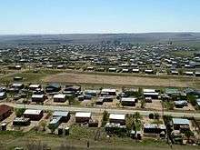
Major cities and towns
The Free State's major towns include:
Health
The Free State is the only province in South Africa that operates a free 24-hour dedicated rotorwing aeromedical service from a public hospital. They are able to reach far flung areas in only 45 minutes and deliver a high level of care on scene. On 31 October 2018 Free State Emergency Medical Service launched an additional 65 road ambulances to augment the fleet.
Free state has many public and private hospitals. Some of them are:
- Bloemfontein Medi-clinic
- Bethlehem Medi-clinic
- Welkom Medi-clinic
- Rosepark Hospital
- Busamed Bram Fischer International Airport Hospital
- Mofumahadi Mmanapo Regional Hospital in Phuthaditjhaba.
As of 20 March 2020, seven people had tested positive for Covid-19 in the province.
Economy
The province is the granary of South Africa, with agriculture central to its economy, while mining on the rich goldfields reef is its largest employer.
Agriculture
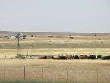
Agriculture dominates the Free State landscape, with cultivated land covering 32,000 square kilometres, and natural veld and grazing a further 87,000 square kilometres of the province. It is also South Africa's leader in the production of biofuels, or fuel from agricultural crops, with a number of ethanol plants under construction in the grain-producing western region. South Africa is one of the top ten Maize producers in the world (12,365,000 tons as of 2013) whereby all of the crops come from the Free State. The Free State is well known for its Mielielande (corn-fields; the former term is in Afrikaans).
Field crops yield almost two-thirds of the gross agricultural income of the province. Animal products contribute a further 30%, with the balance generated by horticulture. Ninety percent of the country's cherry crop is produced in the Ficksburg district, which is also home to the country's two largest asparagus canning factories. Soya, sorghum, sunflowers and wheat are cultivated in the eastern Free State, where farmers specialise in seed production. About 40% of the country's potato yield comes from the province's high-lying areas.
The main vegetable crop is asparagus, both white and green varieties. Although horticulture is expanding and becoming increasingly export-orientated, most produce leaves the province unprocessed.
The Free State's advantage in floriculture is the opposing seasons of the southern and northern hemispheres. The province exports about 1.2 million tons of cut flowers a year.
Mining
The Free State is also rich in mineral wealth, gold representing 20% of the world's total gold production. Mining is the province's major employer. The province has 12 gold mines, producing 30% of South Africa's output and making it the fifth-largest producer of gold in the world. The Harmony Gold Refinery and Rand Refinery are the only two gold refineries in South Africa.
Gold mines in the Free State also supply a substantial portion of the total silver produced in the country, while considerable concentrations of uranium occurring in the gold-bearing conglomerates of the goldfields are extracted as a byproduct.
Bituminous coal is also mined, and converted to petrochemicals at Sasolburg. The Free State also produces high-quality diamonds from its kimberlite pipes and fissures, and the country's largest deposit of bentonite is found in the Koppies district.
Industry
Since 1989, the Free State economy has moved from dependence on primary sectors such as mining and agriculture to an economy increasingly oriented towards manufacturing and export. Some 14% of the province's manufacturing is classified as being in high-technology industries – the highest of all provincial economies. The northern Free State's chemicals sector is one of the most important in the southern hemisphere. Petrochemicals company Sasol, based in the town of Sasolburg, is a world leader in the production of fuels, waxes, chemicals and low-cost feedstock from coal.
Tourism
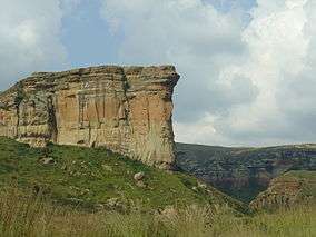
In the northeastern Free State, nestled in the rolling foothills of the Maluti mountains, the Golden Gate Highlands National Park is the province's prime tourist attraction. The park gets its name from the brilliant shades of gold cast by the sun on the spectacular sandstone cliffs, especially the imposing Brandwag or Sentinel Rock, which keeps vigil over the park.
The sandstone of this region has been used for the lovely dressed-stone buildings found on the Eastern Highlands, while decoratively painted Sotho houses dot the grasslands. Some of South Africa's most valued San (Bushman) rock art is found in the Free State, particularly in the regions around Clarens, Bethlehem, Ficksburg, Ladybrand and Wepener.
Demographics


Sesotho is the dominant home language in most of the province. isiZulu is the major language in the far eastern municipality of Phumelela. Setswana is the main language in Tokologo in the northwest, and in and around the area of Thaba Nchu. The Free State is the only province in South Africa with a Sesotho majority. Afrikaans is widely spoken throughout the province, as a first language for the majority of whites and coloureds and as a second or third language by Sesotho, Setswana and isiZulu speakers. Although the numbers of first language English speakers are relatively low, it is becoming increasingly important as the language of business and government. This is further evidenced by the shift of tertiary institutions such as the University of the Free State from Afrikaans to a dual English/Afrikaans medium of instruction.
Ethnicity
The majority of the population are black Africans who speak Sotho as a first language. The vast majority of white people in the Free State are Afrikaans-speaking. In 1880 the white population made up 45.7% of the total population. In 1904 this had fallen to 36.8%.[8] Of the 142,679 people in 1904, only 60% were born in the province. Of the 2,726 European immigrants born in non-British states, 1,025 came from the Russian Empire, mainly Jews. In 1904 whites made up a majority in most settlements, namely Ficksburg (52.3%), Wepener (60.2%), Ladybrand (60.0%), and Kroonstad (51.6%), and made up a substantial minority in Bloemfontein (45.7%) and Winburg (36.3%).
Education
Universities
Other educational institutions
- Flavius Mareka FET College (Kroonstad, Mphohardi, Sasolburg)
- Goldfields FET College (Welkom, Tosa)
- Motheo FET College (Bloemfontein, Botshabelo, Thaba nchu, Koffiefontein)
- Maluti TVET College (QwaQwaˌBethlehem̩ Harrismith)
Secondary schools
- C&N Sekondêre Meisieskool Oranje, Bloemfontein
- Grey College, Bloemfontein
- Eunice High School (Bloemfontein)
- Hoërskool Sentraal (Bloemfontein)
- Hoërskool Jim Fouché (Bloemfontein)
- Hoërskool Fichardtpark (Bloemfontein)
- St. Andrew's School (Bloemfontein)
- St. Michael's School (Bloemfontein)
- Hoërskool Witteberg (Bethlehem)
- Bethlehem Voortrekker High School
- Unitas Secondary School (Welkom)
- Sekgutlong Secondary school (Phuthaditjhaba)
- Mohato Secondary School (Phuthaditjhaba)
- Kwetlisong Secondary School (Petrus Steyn)
Media
Newspapers
- Dumelang News (The People's Paper)
- Die Volksblad (Bloemfontein)
- Bloem news (Bloemfontein)
Radio
- OFM
- Lesedi FM
- Motheo FM
- Radio Rosestad
- Kovsie FM
- CUT FM
Sports
Provincial sport teams
- Soccer
- African Warriors (Phuthaditjhaba)
- Carara Kicks F.C. (Welkom)
- Bloemfontein Celtic (Bloemfontein)
- Free State Stars (Bethlehem)
- Roses United
- Bloemfontein Young Tigers
- Rugby
- Pro14:
- Cheetahs (Bloemfontein) – also represents Northern Cape
- Currie Cup:
- Pro14:
- Cricket
See also
- List of Speakers of the Free State Provincial Legislature
References
- Census 2011: Census in brief (PDF). Pretoria: Statistics South Africa. 2012. ISBN 9780621413885. Archived (PDF) from the original on 13 May 2015.
- "Taking the measure of Namahadi Peak" (PDF). Archived from the original (PDF) on 9 July 2007. Retrieved 24 September 2009.
- Mid-year population estimates, 2019 (PDF) (Report). Statistics South Africa. 31 July 2019. p. 2. Retrieved 31 December 2019.
- "Sub-national HDI - Area Database - Global Data Lab". hdi.globaldatalab.org. Retrieved 13 September 2018.
- "ANC chooses women to be next premiers of Free State, Mpumalanga". News24. Retrieved 22 April 2018.
- "Cheetahs Return to Laohu Valley Reserve & The Free State". Savechinastigers.org. Retrieved 7 March 2017.
- Jens Friis (2 March 2017). "First Wild Cheetahs Born In Free State In Over A Century". Netwerk24. Retrieved 7 March 2017.
- Cana, Frank Richardson (1911). . In Chisholm, Hugh (ed.). Encyclopædia Britannica. 20 (11th ed.). Cambridge University Press. p. 152.
External links
| Wikimedia Commons has media related to Free State. |
| |||||||
| Provinces | |||||||
| Municipalities |
| ||||||
| Settlements |
| ||||||