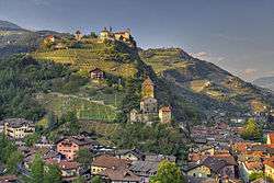
Klausen, South Tyrol
Klausen (German pronunciation: [ˈklaʊ̯sn̩]; Italian: Chiusa [ˈkjuːza]; Ladin: Tluses or Tlüses) is a comune (municipality) in South Tyrol in northern Italy, located about 20 kilometres (12 mi) northeast of the city of Bolzano.
Klausen | |
|---|---|
| Gemeinde Klausen Comune di Chiusa | |
 | |
 Coat of arms | |
Location of Klausen 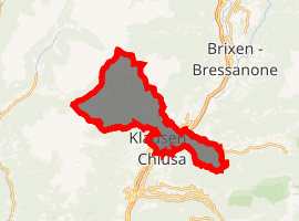
| |
 Klausen Location of Klausen in Italy 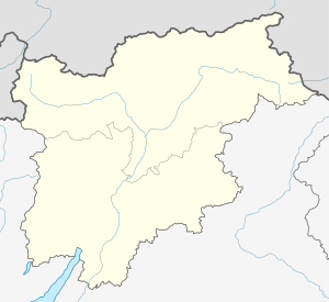 Klausen Klausen (Trentino-Alto Adige/Südtirol) | |
| Coordinates: 46°38′N 11°34′E | |
| Country | Italy |
| Region | Trentino-Alto Adige/Südtirol |
| Province | South Tyrol (BZ) |
| Frazioni | Gufidaun (Gudon), Latzfons (Lazfons), Verdings (Verdignes) |
| Government | |
| • Mayor | Maria Gasser Fink |
| Area | |
| • Total | 51.4 km2 (19.8 sq mi) |
| Elevation | 523 m (1,716 ft) |
| Population (Nov. 2010)[2] | |
| • Total | 5,144 |
| • Density | 100/km2 (260/sq mi) |
| Demonym(s) | German:Klausner Italian: chiusani |
| Time zone | UTC+1 (CET) |
| • Summer (DST) | UTC+2 (CEST) |
| Postal code | 39043 |
| Dialing code | 0472 |
| Website | www |
Geography
As of 30 November 2010, it had a population of 5,144 and an area of 51.4 square kilometres (19.8 sq mi).[3]
Klausen borders the following municipalities: Feldthurns, Lajen, Sarntal, Vahrn, Villanders and Villnöß.
Frazioni
The municipality of Klausen contains the frazioni (subdivisions, mainly villages and hamlets) Gufidaun (Gudon), Latzfons (Lazfons), and Verdings (Verdignes).
History
Klausen is first mentioned in 1027, in a document issued by emperor Conrad II, as Clausa sub Sabiona sita, meaning chasm below the Säben Abbey.[4]
Society
Linguistic distribution
According to the 2011 census, 91.30% of the population speak German, 7.88% Italian and 0.81% Ladin as first language.[6]
Demographic evolution
| Historical population | ||
|---|---|---|
| Year | Pop. | ±% p.a. |
| 1921 | 2,588 | — |
| 1931 | 3,218 | +2.20% |
| 1936 | 3,107 | −0.70% |
| 1951 | 3,344 | +0.49% |
| 1961 | 3,632 | +0.83% |
| 1971 | 3,958 | +0.86% |
| 1981 | 4,098 | +0.35% |
| 1991 | 4,284 | +0.44% |
| 2001 | 4,613 | +0.74% |
References
- "Superficie di Comuni Province e Regioni italiane al 9 ottobre 2011". Istat. Retrieved 16 March 2019.
- "Popolazione Residente al 1° Gennaio 2018". Istat. Retrieved 16 March 2019.
- All demographics and other statistics: Italian statistical institute Istat.
- Martin Bitschnau; Hannes Obermair (2009). Tiroler Urkundenbuch, II. Abteilung: Die Urkunden zur Geschichte des Inn-, Eisack- und Pustertals. Vol. 1: Bis zum Jahr 1140. Innsbruck: Universitätsverlag Wagner. pp. 171–2 no. 199. ISBN 978-3-7030-0469-8.
- Heraldry of the World: Klausen
- "Volkszählung 2011/Censimento della popolazione 2011". astat info. Provincial Statistics Institute of the Autonomous Province of South Tyrol (38): 6–7. June 2012. Retrieved 2012-06-14.
- Nürnberg International - Informationen zu den Auslandsbeziehungen der Stadt Nürnberg
- https://www.planegg.de/Planegg-und-seine-Partner.o986.html?suche=Klausen+
External links

- (in German and Italian) Homepage of the municipality