Kunduz
Kunduz (/kʊnduːz/; Pashto: کندز; Dari: قندوز original name: کُهَندِژ) is a city in northern Afghanistan, which serves as the capital of Kunduz Province. The city has a population of about 268,893,[2] making it about the 6th-largest city of Afghanistan, and the largest city in the northeastern section of the country. Kunduz is located in the historical Tokharistan region of Bactria, near the confluence of the Kunduz River with the Khanabad River. Kunduz is linked by highways with Kabul to the south, Mazar-i-Sharif to the west, and Badakhshan to the east. Kunduz is also linked with Dushanbe in Tajikistan to the north, via the Afghan dry port of Sherkhan Bandar.
Kunduz کندز | |
|---|---|
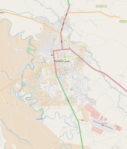 | |
 Kunduz Location in Afghanistan | |
| Coordinates: 36°43′43″N 68°52′5″E | |
| Country | |
| Province | Kunduz Province |
| District | Kunduz District |
| First mention | 329 BC |
| Elevation | 391 m (1,283 ft) |
| Population (2012)[1] | |
| • City | 268,893 |
| • Urban | 268,893 |
| Time zone | UTC+4:30 (Afghanistan Standard Time) |
| Climate | BSk |
The land use of the city (within the municipal boundary) is largely agricultural (65.8% of total area). Residential land comprises nearly half of the 'built-up' land area (48.3%) with 29,877 dwellings.[2] Institutional land comprises 17.9% of built-up land use, given that the airport is located within the municipal boundary.[2]
Etymology
Kunduz is also sometimes spelled (romanized) as Kundûz, Qonduz, Qondûz, Konduz, Kondûz, Kondoz, or Qhunduz. The name of the city is derived from Persian compound, kuhan diz, "old/ancient fort".
Until the 1960s, the city served as the capital to the now-defunct province of Qataqan, itself meaning "Old/Ancient city" (from Turkic kata ("old/ancient") and Eastern Iranian (Sogdian) kand, "fort", "town").
History
Kunduz is the site of the ancient city of Drapsaka. It was a great centre of Buddhist learning and very prosperous during the 3rd century AD.
The city used to be called Walwalij[3] (or Varvarliz) and the name Kuhandiz began to be used from the Timurid time.
In the 18th and 19th centuries it was the capital of a rather large eponymous, sometimes independent, sometimes autonomous Uzbek-Tajik khanate that in the 1820s encompassed land from Balkh to the Pamir Mountains. It was part of The Great Game between the British and Russians. This khanate was finally destroyed by Afghanistan in 1859. Between one hundred and two-hundred thousand Tajiks and Uzbeks fled the conquest of their homeland by Russian Red Army and settled in northern Afghanistan.[4]
In the early 20th century, under the governance of Sher Khan Nasher, Kunduz became one of the wealthiest Afghan provinces. This was mainly due to Nasher's founding of the Spinzar Cotton Company, which continues to exist in post-war Afghanistan.
Kunduz is the most important agricultural province which produces wheat, rice, millet, and other products and obtained the nickname of "the hive of the country."
Kunduz is the centre for the northeast provinces and was captured by the Taliban in 1997. It was the last major city held by the Taliban before its fall to US-backed Afghan Northern Alliance forces on 26 November 2001. The city is strategically important because it is the only way connecting Takhar province and Badakhshan provinces, which play a critical role in the existing government.
During the summer of 2015, the Taliban advanced and attacked the city, which resulted in a battle for control of the city against Afghan forces. Tens of thousands of inhabitants were displaced internally by the fighting.[5][6][7] On 28 September 2015 the Taliban flag was again raised in the city center and the Taliban managed to capture the city prison and free many prisoners.[8][9] The Afghan Armed Forces counter-attacked and managed to re-capture the city in 15 days. The Taliban announced that, after achieving their objectives, they have withdrawn from the city's center. Zabiullah Mujahid, a Taliban spokesperson, said that their main object in leaving the city is to avoid civilian casualties from air raids.[10] In April 2018 the Afghan Air Force conducted an airstrike that killed and injured dozens of civilians at a religious school in Kunduz.[11] On 31 August 2019, the Taliban forces launched another attack on the city, setting off a major battle with local security forces.
On 19 May 2020, the Taliban killed one policeman and one civilian and injured 18 others in a motorbike bomb blast in Kunduz. On the same day, the Taliban attempted again to capture Kunduz, attacking several government posts but were repelled by the Afghan security forces. The Taliban were forced to flee the city, leaving ten dead bodies behind.[12] Eight Afghan soldiers and three civilians were killed and 55 others were wounded during the Taliban attack.[13]
Geography
Kunduz is located at a strategic location, on the main north-south highway linking Kabul to Tajikistan, and east-west Mazar-i-Sharif to Taloqan and Fayzabad.
Climate
.jpg)
Kunduz has a cold semi-arid climate (Köppen climate classification BSk) with hot summers and cool winters. Precipitation is generally low except from January to April, with summers almost always rainless.
| Climate data for Kunduz | |||||||||||||
|---|---|---|---|---|---|---|---|---|---|---|---|---|---|
| Month | Jan | Feb | Mar | Apr | May | Jun | Jul | Aug | Sep | Oct | Nov | Dec | Year |
| Record high °C (°F) | 21.2 (70.2) |
25.0 (77.0) |
32.8 (91.0) |
38.9 (102.0) |
42.2 (108.0) |
46.2 (115.2) |
45.3 (113.5) |
44.2 (111.6) |
39.2 (102.6) |
39.4 (102.9) |
28.4 (83.1) |
21.6 (70.9) |
46.2 (115.2) |
| Average high °C (°F) | 6.3 (43.3) |
9.5 (49.1) |
15.8 (60.4) |
23.0 (73.4) |
29.8 (85.6) |
37.3 (99.1) |
39.0 (102.2) |
36.9 (98.4) |
31.8 (89.2) |
24.5 (76.1) |
16.0 (60.8) |
9.7 (49.5) |
23.3 (73.9) |
| Daily mean °C (°F) | 1.6 (34.9) |
4.4 (39.9) |
10.4 (50.7) |
17.2 (63.0) |
22.9 (73.2) |
29.3 (84.7) |
31.3 (88.3) |
29.2 (84.6) |
23.9 (75.0) |
16.9 (62.4) |
9.5 (49.1) |
4.4 (39.9) |
16.8 (62.1) |
| Average low °C (°F) | −2.4 (27.7) |
0.0 (32.0) |
5.7 (42.3) |
11.6 (52.9) |
15.7 (60.3) |
20.9 (69.6) |
23.3 (73.9) |
21.5 (70.7) |
16.3 (61.3) |
10.6 (51.1) |
4.1 (39.4) |
0.0 (32.0) |
10.6 (51.1) |
| Record low °C (°F) | −22.7 (−8.9) |
−23.1 (−9.6) |
−11.8 (10.8) |
−2.1 (28.2) |
4.2 (39.6) |
12.5 (54.5) |
15.7 (60.3) |
12.6 (54.7) |
3.5 (38.3) |
−2.0 (28.4) |
−9.8 (14.4) |
−20 (−4) |
−23.1 (−9.6) |
| Average precipitation mm (inches) | 44.0 (1.73) |
56.5 (2.22) |
76.7 (3.02) |
54.4 (2.14) |
29.8 (1.17) |
0.1 (0.00) |
1.3 (0.05) |
0.3 (0.01) |
0.1 (0.00) |
7.3 (0.29) |
23.7 (0.93) |
28.4 (1.12) |
322.6 (12.68) |
| Average rainy days | 5 | 6 | 11 | 10 | 9 | 1 | 1 | 0 | 0 | 3 | 5 | 6 | 57 |
| Average snowy days | 5 | 4 | 2 | 0 | 0 | 0 | 0 | 0 | 0 | 0 | 1 | 2 | 14 |
| Average relative humidity (%) | 80 | 75 | 75 | 71 | 54 | 31 | 28 | 29 | 32 | 44 | 63 | 76 | 55 |
| Mean monthly sunshine hours | 114.4 | 114.6 | 158.9 | 201.0 | 276.5 | 332.1 | 340.2 | 315.5 | 289.7 | 221.8 | 169.3 | 118.3 | 2,652.3 |
| Source: NOAA (1958-1983) [14] | |||||||||||||
Demography
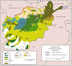
The city of Kunduz has a population of about 268,893,[2] while Kunduz District has a population of 304,600.[1] Ethnic Pashtuns comprise the largest segment, followed by Uzbeks, Tajiks, Arabs and a few others.[4][15][16] Kunduz is the capital of a highly diverse province that includes significant populations of Pashtuns, Tajiks, Uzbeks, Karluks, Hazaras, Arabs, Moghols, Balochis and Turkmens.[17]
Kunduz Arabs speak Persian and Pashto, Afghanistan's two official languages, rather than Arabic. However, they claim a strong Arab identity, based on their tribal origins in Arabia. This may in fact point to the seventh- and eighth-century migration to this and other Central Asian locales of many Arab tribes from Arabia in the wake of the Islamic conquests of the region.[18]
Administration
Kunduz city is divided into 8 Police Districts ('Nahias') with a total land area of 11,206 hectares.[2]
Kunduz Province is divided into six districts: Khan Abad, Ali Abad, Char Dara, Dashti Archi, Qala-e-Zal and Imam Sahib, plus Kunduz City. Kunduz has nine representatives in the lower house and two in the upper house and has a provincial council. The most influential leader of Kunduz was Arif Khan, who was a governor of Kunduz Province and was shot dead in the city of Peshawar, Pakistan in the year 2000. Soon after the incident his brother Haji Omar Khan took his responsibility and was appointed as the Governor of Kunduz (2000–01). In the Karzai administration, Haji Omar Khan was elected to be a representative of Kunduz Province in the Lower House (Wolasi Jirga) and at a time serve as an advisor minister to President Hamid Karzai.
Notable people
- Spinzar Cotton Company founders, Ghulam Sarwar Nashir, Nazik Mir Khan Zakhel, and Raees Munawar Khan seen as the founding fathers of the province.
- Gholam Nabi Nasher Khan (1926–2010), parliamentarian
- Sayed Noorullah Murad (Afghan politician, member of federal cabinet, military commander & scholar) Imam Saheb district.
- Javed Ahmadi (1992–), player in the current Afghanistan national cricket team
- Abdul Rauf Ibrahimi is current Afghan National Parliament Speaker.
See also
- List of cities in Afghanistan
- Farhad Darya
- Sayed Noorullah Murad (Afghan politician, member of federal cabinet, military commander & scholar) Imam Saheb district.
- 2009 Kunduz airstrike, (2015) Kunduz hospital airstrike, Kunduz Trauma Centre
- Kunduz Airport
- Kunduz University
- Battle of Kunduz (2015)
- Battle of Kunduz (2016)
- Kunduz Province
References
- "Settled Population of Kunduz province by Civil Division, Urban, Rural and Sex-2012-13" (PDF). Retrieved 12 January 2014.
- "The State of Afghan Cities 2015". Retrieved 11 October 2015.
- "Asien-Afrika-Institut". uni-hamburg.de. Archived from the original on 9 May 2012.
- Wörmer, Nils (2012). "The Networks of Kunduz: A History of Conflict and Their Actors, from 1992 to 2001" (PDF). Stiftung Wissenschaft und Politik. Afghanistan Analysts Network. p. 8. Retrieved 12 January 2014.
- "Afghans counter Taliban offensive in northern Kunduz province". BBC News.
- "Taliban and Afghan Government Dispute Status of Kunduz". New York Times. 21 June 2015.
- "Afghanistan: Taliban advance on key northern city". The Sydney Morning Herald.
- "Taliban 'seize half' of Afghanistan's Kunduz city". www.bbc.com. BBC. 28 September 2015. Retrieved 28 September 2015.
- "Afghan Taliban seize northern city center in major attack". Reuters. 28 September 2015. Retrieved 28 September 2015.
- "Taliban admit Kunduz withdrawal". 13 October 2015. Retrieved 8 April 2018 – via www.bbc.com.
- cbs/AFP (3 April 2018). "Carnage as airstrike hits boy's school in Taliban territory". Retrieved 13 April 2018.
- "Motorbike bomb, fighting claim 12 lives in Afghanistan's Kunduz province". 19 May 2020 – via http://www.xinhuanet.com/.
- "Eight Afghan soldiers die fighting off Taliban attack on key city". 19 May 2020 – via au.news.yahoo.com/.
- "Kunduz Climate Normals 1958-1983". National Oceanic and Atmospheric Administration. Retrieved 25 December 2012.
- "Kunduz Province" (PDF). Program for Culture & Conflict Studies. Naval Postgraduate School. Archived from the original (PDF) on 2 October 2012. Retrieved 12 January 2014.
- "2003 National Geographic Population Map" (PDF). Thomas Gouttierre, Center For Afghanistan Studies, University of Nebraska at Omaha; Matthew S. Baker, Stratfor. National Geographic Society. 2003. Retrieved 18 June 2017.
- Bleuer, Christian (1 January 2012). "State-building, migration and economic development on the frontiers of northern Afghanistan and southern Tajikistan". Journal of Eurasian Studies. 3 (1): 69–79. doi:10.1016/j.euras.2011.10.008.
- Barfield, T.J. (1981), The Central Asian Arabs of Afghanistan: Pastoral Nomadism in Transition, University of Texas Press, ISBN 9780292710665
Further reading
- Dupree, Nancy Hatch (1977): An Historical Guide to Afghanistan. 1st Edition: 1970. 2nd Edition. Revised and Enlarged. Afghan Tourist Organization.
- Thomas J. Barfield, The Central Asian Arabs of Afghanistan: Pastoral Nomadism in Transition. 1982.
External links
| Wikimedia Commons has media related to Kunduz. |
- Kunduz Province by Naval Postgraduate School
- Welcome to Kunduz, Allauddin
- . Encyclopædia Britannica (11th ed.). 1911.