Klaeng District
Klaeng District (Thai: แกลง, pronounced [klɛ̄ːŋ]) is a district (amphoe) on the coast of Rayong Province, eastern Thailand.
Klaeng แกลง | |
|---|---|
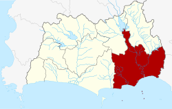 District location in Rayong Province | |
| Coordinates: 12°46′42″N 101°39′12″E | |
| Country | Thailand |
| Province | Rayong |
| Area | |
| • Total | 788.463 km2 (304.427 sq mi) |
| Population (2008) | |
| • Total | 77,286[1] |
| • Density | 159.4/km2 (413/sq mi) |
| Time zone | UTC+7 (ICT) |
| Postal code | 21110 |
| Geocode | 2103 |
History
Klaeng's history dates back to the Ayutthaya Kingdom. Due to its location mid-way between Mueang Rayong District and Chanthaburi Province and due to its abundance of natural resources such as fertile rice fields and many watercourses, it has been a magnet for immigration.[2]
Since the Ayutthaya period, Klaeng has been a place to gather people for war service.[2]
In the reign of King Rama V, Mueang Klaeng was a fourth class city under Monthon Chanthaburi. The former city offices were in Ban Laem Mueang, Tambon Paknam Prasae. In 1897 the office was moved to Ban Pho Thong, on the north side of Wat Pho Thong. In 1908 Mueang Klaeng was downgraded to a district of Rayong Province.[3]
Geography
Neighboring districts are (from the west clockwise): Mueang Rayong, Wang Chan, and Khao Chamao of Rayong Province; Kaeng Hang Maeo and Na Yai Am of Chanthaburi Province. To the south is the Gulf of Thailand.
Klaeng's main watercourse is the Prasae River.[4] Its name is assumed to be from Chong Sae (แซรฺ), which means 'rice field'.[2]
Administration
The district is divided into 15 sub-districts (tambons), which are further subdivided into 146 villages (mubans). Klaeng is a town (thesaban mueang) which covers parts of tambons Thang Kwian and Wang Wa. There are a further four sub-district municipalities (thesaban tambons): Kong Din covers parts of tambon Kong Din, Thung Khwai Kin parts of tambons Thung Khwai Kin and Khlong Pun, Pak Nam Prasae, parts of tambons Pak Nam Krasae and Sunthorn Phu, and the entiretambons of Kram and Chak Phong. There are also 15 tambon administrative organizations (TAO).
| No. | Name | Thai | Villages | Pop.[5] |
|---|---|---|---|---|
| 1. | Thang Kwian | ทางเกวียน | 10 | 23,040 |
| 2. | Wang Wa | วังหว้า | 14 | 10,661 |
| 3. | Chak Don | ชากโดน | 8 | 4,786 |
| 4. | Noen Kho | เนินฆ้อ | 9 | 4,525 |
| 5. | Kram | กร่ำ | 6 | 5,574 |
| 6. | Chak Phong | ชากพง | 7 | 8,949 |
| 7. | Krasae Bon | กระแสบน | 14 | 7,406 |
| 8. | Ban Na | บ้านนา | 13 | 8,250 |
| 9. | Thung Khwai Kin | ทุ่งควายกิน | 13 | 14,808 |
| 10. | Kong Din | กองดิน | 11 | 10,175 |
| 11. | Khlong Pun | คลองปูน | 9 | 5,871 |
| 12. | Phang Rat | พังราด | 8 | 6,095 |
| 13. | Pak Nam Krasae | ปากน้ำกระแส | 8 | 6,884 |
| 17. | Huai Yang | ห้วยยาง | 9 | 3,646 |
| 18. | Song Salueng | สองสลึง | 8 | 5,619 |
Missing numbers are tambons which now form Khao Chamao District.
References
- "Statistical Report on Population and Housing in each district, district and sub-district As of December 2008". Department of Provincial Administration (DOPA). Archived from the original on 30 May 2009. Retrieved 29 August 2019.
- Wongthes, Sujit (29 August 2017). "พระเจ้าตาก ไม่อ้อมไปทางชลบุรี และสังฆราชชื่น เมืองแกลง (จ.ระยอง)" [King Taksin does not detour to Chonburi and Sangharaja Chuen, Klaeng Town (Rayong Province)]. Matichon (in Thai) (15145). Retrieved 29 August 2019.
- แจ้งความกระทรวงมหาดไทย (PDF). Royal Gazette (in Thai). 25 (13): 407. 1908-06-28.
- Mekloy, Pongpet (23 May 2019). "Return to Prasae River". Bangkok Post. Retrieved 14 October 2019.
- "Population statistics 2008". Department of Provincial Administration. Archived from the original on 2009-05-30.
External links
- amphoe.com(Thai)