Kingsbury, London
Kingsbury is a district of northwest London in the London Borough of Brent. The name Kingsbury means "The King's Manor". Its ancient scope stretches north and west to include Queensbury and parts of Kenton and Wembley Park in other directions. Kingsbury was in 2001 a ward and in 2011 was identifiable with the Fryent and Barnhill wards approximately. About 25% of Kingsbury is Fryent Country Park, forming the southern quarter. It is of highly mixed density, ranging from high rise to suburban to a green wildlife reserve in the country park. It is within The Hyde's NW9 postal district.
| Kingsbury | |
|---|---|
 St Andrews Road and Church, Kingsbury | |
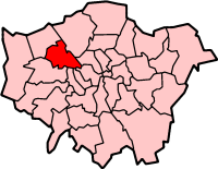
 Kingsbury Location within Greater London | |
| Area | 5.63 km2 (2.17 sq mi) |
| Population | 29,217 |
| • Density | 5,190/km2 (13,400/sq mi) |
| OS grid reference | TQ195885 |
| London borough | |
| Ceremonial county | Greater London |
| Region | |
| Country | England |
| Sovereign state | United Kingdom |
| Post town | LONDON |
| Postcode district | NW9 |
| Dialling code | 020 |
| Police | Metropolitan |
| Fire | London |
| Ambulance | London |
| UK Parliament | |
| London Assembly | |
History
Kingsbury was historically a rural parish of a fairly modest 6.9 square kilometres (2.7 sq mi) in the Hundred of Gore and county of Middlesex.[1] It formerly included Queensbury.[2] Following local government redrawing of electoral wards Kingsbury corresponds to the Fryent and Barnhill wards and in all of its various older guises, a minority or all of the Queensbury ward.[3]
The early English kings had parted with their manor of Kingsbury long before the Conquest. An estate called Tunworth, in the northern part of Kingsbury parish, was granted by Edwy to his thegn Lyfing in 957. By 1066 it probably formed part of the manor of Kingsbury, which was then held by Wlward White, a thegn of the Confessor, and passed from him to Ernulf of Hesdin who died in 1097 and his lands passed to the family of Walter of Salisbury. Thereafter the overlordship of Kingsbury descended with Edgware manor. By 1086 on the Domesday survey of property, Ernulf's manor in Kingsbury had been subinfeudated to Albold as Lord. It was not mentioned again until 1317, when, under the name of the manor of Kingsbury, it belonged to Baldwin Poleyn of Tebworth.[4]
Kingsbury developed little in housing and population in the 19th century, remaining a polyfocal village. In this age, Oliver Goldsmith, writer and playwright, lived at Hyde Farm, Kingsbury (1771–1774); the third Lord Mansfield was buried at St. Andrew's churchyard in 1840.
Although it lay close to London, development started slowly, and it was not until after the First World War that the district became built up. An aircraft industry was established in the part of Kingsbury adjacent to Hendon aerodrome during the war, while the road network was improved to cater for the British Empire Exhibition in nearby Wembley in 1924.[5] The number of inhabited houses in the civil parish increased from just 140 in 1901 to 3,937 in 1931. By 1951 this had risen to 11,776.[6] Between 1921 and 1931 Kingsbury's population increased by 796%.[5]
Population growth meant the existing parish church, built in 1884, dedicated to the Holy Innocents, and adjacent to the more historic Old St Andrew's church, became too small. It was replaced during the 1930s. The current church, completed to designs by Samuel Daukes in 1847, had originally been constructed in Wells Street in central London but after its use declined it was deconstructed, transported and rebuilt (by Holland, Hannen & Cubitts, directed by architect William Adam Forsyth) in its entirety in Kingsbury in 1933–34.[7][8][9]
John Logie Baird's experimental television transmissions from the United Kingdom to Berlin, Germany were transmitted from the stable block of Kingsbury Manor, now the Veterans Club in Roe Green Park.
From 1923 to 1979 Kingsbury Road was the location of the Vanden Plas specialist motor body works, body makers for Bentley and later part of Austin, BMC, and British Leyland. The site is now Kingsbury Trading Estate.

A congregation of Jews affiliated to the United Synagogue is first recorded in Kingsbury in 1939. In 1942 Eden Lodge at Kingsbury Green was registered for worship, becoming Kingsbury district synagogue in 1954.[10]
Local government
In 1894 Kingsbury was included in the urban district of Wembley. However, as Kingsbury had only three councillors on the urban district council to Wembley's nine, Kingsbury's councillors felt the needs of the area were not well-served. In 1900 Kingsbury became a separate urban district with six councillors. The new council was immediately involved in controversy and in 1906 it failed to make a rate or meet its financial commitments. Following an inquiry initiated by ratepayers, the councillors numbered nine, not halting fiscal accusations directed towards the initial three councillors.[11]
In 1934 the Kingsbury Urban District was abolished and merged once more in Wembley Urban District. The urban district became a municipal borough in 1937 and in 1965 the area became part of the London Borough of Brent.[11]
Demography
The 2011 census showed that the Fryent ward's largest ethnic group was Indian at 21%. Whites as a whole form 37% (17% British, 14% Other, 6% Irish). 11% was Other Asian. 41% were Christian, 21% Muslim and 20% Hindu.[12] The Welsh Harp ward, which covers southern areas of Kingsbury Green, was 17% White Other, 17% Indian, and 16% White British.[13]
In film, literature and music
The first two series of BBC children's drama Grange Hill were filmed at Kingsbury High School.[14] Video of Round Here, about George Michael's childhood, features Roe Green Park, Roe Green Primary School and other local landmarks.
Notable people
- John Beard (trade unionist), had his last home in 27 Wyndale Avenue at the time of his death in 1950.[15]
- James Hanratty, among last condemned to hang for murder, lived in Kingsbury.
- Charlie Watts, drummer of The Rolling Stones, was raised in Kingsbury. [16]
- Julie Rogers, singer, was educated and lived in Kingsbury.
- Shirley Eaton, actress.
- Courtney Pine OBE, jazz musician, was raised in Kingsbury from age 14.[17]
- Chris Squire, bassist of Yes and The Syn, was born in Kingsbury.
- Steve Nardelli, guitarist and vocalist wth The Syn, went to Kingsbury County Grammar School.
- Tony Kanal, bassist of No Doubt, was raised in Kingsbury.[18]
- Mutya Buena and Keisha Buchanan, singer/songwriters, Sugababes, born and raised in Kingsbury.
- Jet Harris, musician with Tony Meehan and The Shadows, was born in Kingsbury.
- Gary Waddock, former Wycombe Wanderers manager, was born in Kingsbury.
- Jasmyn Banks, actress, was educated in Kingsbury.
- Stuart Pearce, footballer, raised in Kingsbury.
- George Michael, singer and songwriter, was raised in Kingsbury.
- Brian Michaels, theatre and opera director, was born and raised in Kingsbury.
- Liam Beary, just for being Liam Beary, born and raised in Kingsbury.
Geography
Some historical maps show Kingsbury to be centred to the south of Church Lane around Blackbird Hill, an area that is seldom referred to as Kingsbury today but instead Wembley Park or Neasden.
Neighbouring areas
Neighbouring areas of Kingsbury | ||||||||||
|---|---|---|---|---|---|---|---|---|---|---|
| ||||||||||
Transport
Roads
Kingsbury Road A4006 is the largest road within the district.
Buses
London Buses serving Kingsbury are:
| Route | Start | End | Operator |
| 79 | Alperton Sainsburys | Edgware | Metroline |
| 83 | Alperton | Golders Green | Metroline |
| 183 | Pinner | Golders Green | London Sovereign |
| 204 | Sudbury | Edgware | Metroline |
| 302 | Mill Hill Broadway | Kensal Rise | Metroline |
| 303 | Kingsbury Circle | Edgware | London Sovereign |
| 324 | Brent Cross Tesco | Stanmore | London Sovereign |
| 628 | Southgate | Kingsbury JFS | Sullivan Buses |
| 653 | Muswell Hill | Kingsbury JFS | Sullivan Buses |
| 683 | Friern Barnet | Kingsbury JFS | Sullivan Buses |
| 688 | Kingsbury JFS | Southgate | Sullivan Buses |
| N83 | Ealing Hospital | Golders Green | Metroline |
| N98 | Holborn | Stanmore | Metroline |
Local parks
- Barn Hill Open Space
- Fryent Country Park
- Kingsbury Green Recreation Ground
- Roe Green Park
- Silver Jubilee Park
- Grove Park Open Space
- Eton Grove Park
Schools
- Kingsbury High School
- Jewish Free School (JFS)
- Fryent Primary School
- Oliver Goldsmith Primary School
- Kingsbury Green Primary School
- Roe Green Primary School
- St Robert Southwell Primary School
References
- T F T Baker, R B Pugh (editors), A P Baggs, Diane K Bolton, Eileen P Scarff, G C Tyack (1976). "Kingsbury: Introduction". A History of the County of Middlesex: Volume 5. Institute of Historical Research. Retrieved 5 November 2014.CS1 maint: multiple names: authors list (link)
- Map of established parishes, A History of the County of Middlesex, Volume 5.
- Boundary Viewer Office for National Statistics
- T F T Baker, R B Pugh (Editors), A P Baggs, Diane K Bolton, Eileen P Scarff, G C Tyack (1976). "Kingsbury: Manors". A History of the County of Middlesex: Volume 5. Institute of Historical Research. Retrieved 5 November 2014.CS1 maint: multiple names: authors list (link)
- "Places in Brent: Kingsbury", Grange Museum of Community History and Brent Archive, accessed 28 January 2008.
- "Kingsbury: Introduction", Victoria County History of Middlesex, Volume 5 (British History Online), accessed 28 January 2008.
- St Andrew’s Church, formerly in Wells Street, now at Kingsbury, Middlesex. Survey of London,University College London, 1 April 2016. Retrieved 5 September 2017.
- "Kingsbury's Recycled Church" (PDF). Brent.gov.uk. London Borough of Brent. Retrieved 20 February 2020.
- "SAINT ANDREW, SAINT MARYLEBONE: WELLS STREET, WESTMINSTER". AIM25 Archive. Retrieved 20 February 2020.
- T F T Baker, R B Pugh (Editors), A P Baggs, Diane K Bolton, Eileen P Scarff, G C Tyack (1976). "Kingsbury: Judaism". A History of the County of Middlesex: Volume 5. Institute of Historical Research. Retrieved 5 November 2014.CS1 maint: multiple names: authors list (link)
- "Kingsbury: Local Government", Victoria County History of Middlesex, Vol. 5, (British History Online), accessed 28 January 2008.
- Good Stuff IT Services. "Fryent - UK Census Data 2011". Ukcensusdata.com. Retrieved 22 March 2017.
- Good Stuff IT Services. "Welsh Harp - UK Census Data 2011". Ukcensusdata.com. Retrieved 22 March 2017.
- "Grange Hill (1978–2008) | Filming Locations", IMDB.
- Who Was Who, 1941–1950. A and C Black. 1952. p. 76.
- "Archived copy". Archived from the original on 11 August 2017. Retrieved 2 February 2019.CS1 maint: archived copy as title (link)
- Maya Jaggi (30 September 2000). "Profile: Courtney Pine | Music". The Guardian. Retrieved 22 March 2017.
- "And the band plays on... - Times of India". Timesofindia.indiatimes.com. 1 December 2002. Retrieved 22 March 2017.
External links
| Wikimedia Commons has media related to Kingsbury. |
- Kingsbury heritage
- Kingsbury history
- Highfort Court, Buck Lane. Designed in the style of a fortified castle by local architect E. G. Trobridge
- Vanden Plas Kingsbury Works - A Potted History
| Districts |
|  | ||
|---|---|---|---|---|
| Attractions |
| |||
| Parks and open spaces |
| |||
| Constituencies | ||||
| Tube and rail stations |
| |||
| Other topics | ||||
| ||||