Kawaala
Kawaala is a neighborhood within Kampala, Uganda's capital and largest city.
Kawaala | |
|---|---|
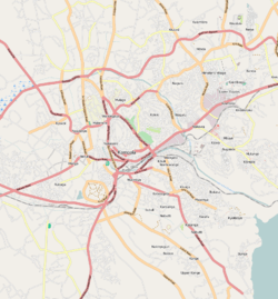 Kawaala Map of Kampala showing the location of Kawaala. | |
| Coordinates: 00°20′24″N 32°33′00″E | |
| Country | |
| Region | Central Uganda |
| District | Kampala Capital City Authority |
| Division | Lubaga Division |
| Elevation | 1,220 m (4,000 ft) |
| Time zone | UTC+3 (EAT) |
Location
Kawaala is bordered by Nabweru to the north, Kazo to the northeast, Makerere to the east, Naakulabye to the south, Kasubi to the southwest, and Namungoona to the west. This is approximately 5 kilometres (3.1 mi), by road, north of Kampala's central business district.[1] The coordinates of Kawaala are 0°20'24.0"N, 32°33'00.0"E (Latitude:0.3400; Longitude:32.5500).[2]
Overview
Kawaala is predominantly a low-income residential neighborhood, with an occasional middle-class residence among the low income shacks. The Kampala Northern Bypass Highway passes through Kawaala. Some of the points of interest in the neighborhood include the following:
- Good Times Infant School - A private K-P7, mixed day school.
- Trinity Family Nursery and Primary School - A private Nursery-P7, mixed day school.
- Kawaala Health Center III - A health facility, owned and operated by Kampala Capital City Authority (KCCA).
- Glory of Christ Church - A place of worship affiliated with the Pentecostal Movement[3]
See also
- Kampala District
- Kampala Northern Bypass Highway
- Lubaga Division
- Kasubi Tombs
References
- "Map Showing Kampala And Kawaala With Distance Indicator". Globefeed.com. Retrieved 17 June 2014.
- Google. "Location of Kawaala at Google Maps". Google Maps. Retrieved 17 June 2014.
- Mulumba, Abu-Baker (27 May 2014). "Ssenyonga Thrills Kawaala". The Observer (Uganda). Retrieved 16 June 2014.
External links
This article is issued from Wikipedia. The text is licensed under Creative Commons - Attribution - Sharealike. Additional terms may apply for the media files.