Kandi, Benin
Kandi is a town, arrondissement and commune in the Alibori Department of eastern Benin. Originally a market town, Kandi is now primarily a farming centre. It lies on the nation's main north-south highway, 650 km (400 mi) from Cotonou and 523 km (325 mi) north of Porto-Novo.[2] The town is the capital of the department of Alibori. The commune covers an area of 3,421 km2 (1,321 sq mi) and as of 2013 had a population of 177,683 people.[3][4] The town itself had a population of 27,227 in 2002.
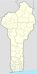
Kandi | |
|---|---|
 Kandi Location in Benin | |
| Coordinates: 11°07′43″N 2°56′13″E | |
| Country | |
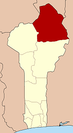
| Department | Alibori Department |
| Area | |
| • Total | 3,421 km2 (1,321 sq mi) |
| Elevation | 288 m (945 ft) |
| Population (2013)[1] | |
| • Total | 177,683 |
| • Density | 52/km2 (130/sq mi) |
| Time zone | UTC+1 (WAT) |
| Postal address | BP: 30 |
| Area code(s) | (+229) 23 |
History
Kandi was founded by the Bariba Kingdom, an offshoot of the Borgu Confederation. The surrounded villages are Bariba people in south and west, and the Mokole Yoruba in the north, who fled the wars of the foundation of the Oyo Empire. The surrounding countryside is Bariba.
Geography
The commune of Kandi is located 650 kilometres (400 mi) from Cotonou. Communally it is bounded to the north by Malanville, south by Gogounou, west by Banikoara and to the east by Ségbana.
Climate
Kandi has a tropical savanna climate (Köppen climate classification Aw).
| Month | Jan | Feb | Mar | Apr | May | Jun | Jul | Aug | Sep | Oct | Nov | Dec | Year |
|---|---|---|---|---|---|---|---|---|---|---|---|---|---|
| Record high °C (°F) | 41.2 (106.2) |
43.0 (109.4) |
43.3 (109.9) |
43.9 (111.0) |
43.3 (109.9) |
40.9 (105.6) |
38.9 (102.0) |
39.9 (103.8) |
39.8 (103.6) |
41.5 (106.7) |
39.5 (103.1) |
39.5 (103.1) |
43.9 (111.0) |
| Average high °C (°F) | 33.6 (92.5) |
36.4 (97.5) |
38.4 (101.1) |
38.6 (101.5) |
36.2 (97.2) |
33.3 (91.9) |
30.9 (87.6) |
30.2 (86.4) |
31.1 (88.0) |
34.2 (93.6) |
35.3 (95.5) |
33.8 (92.8) |
34.3 (93.7) |
| Daily mean °C (°F) | 24.9 (76.8) |
27.8 (82.0) |
30.9 (87.6) |
32.1 (89.8) |
30.4 (86.7) |
28.1 (82.6) |
26.4 (79.5) |
26.0 (78.8) |
26.2 (79.2) |
27.8 (82.0) |
26.5 (79.7) |
24.8 (76.6) |
27.7 (81.9) |
| Average low °C (°F) | 16.1 (61.0) |
19.2 (66.6) |
23.4 (74.1) |
25.6 (78.1) |
24.6 (76.3) |
22.9 (73.2) |
21.9 (71.4) |
21.8 (71.2) |
21.4 (70.5) |
21.4 (70.5) |
17.7 (63.9) |
15.8 (60.4) |
21.0 (69.8) |
| Record low °C (°F) | 10.0 (50.0) |
12.6 (54.7) |
15.2 (59.4) |
17.0 (62.6) |
16.5 (61.7) |
14.9 (58.8) |
18.6 (65.5) |
19.0 (66.2) |
15.0 (59.0) |
14.0 (57.2) |
10.8 (51.4) |
5.0 (41.0) |
5.0 (41.0) |
| Average precipitation mm (inches) | 0.2 (0.01) |
2.9 (0.11) |
8.2 (0.32) |
40.5 (1.59) |
107.0 (4.21) |
152.7 (6.01) |
196.9 (7.75) |
271.9 (10.70) |
190.9 (7.52) |
34.1 (1.34) |
0.5 (0.02) |
0.6 (0.02) |
1,006.6 (39.63) |
| Average precipitation days (≥ 1.0 mm) | 0 | 0 | 1 | 3 | 8 | 10 | 13 | 16 | 13 | 3 | 0 | 0 | 67 |
| Average relative humidity (%) | 33 | 28 | 36 | 52 | 65 | 75 | 82 | 85 | 85 | 76 | 54 | 40 | 59 |
| Mean monthly sunshine hours | 279.0 | 257.6 | 260.4 | 255.0 | 272.8 | 252.0 | 223.2 | 195.3 | 213.0 | 275.9 | 282.0 | 279.0 | 3,045.2 |
| Source 1: NOAA[5] | |||||||||||||
| Source 2: Deutscher Wetterdienst (humidity, 1951–1967),[6] Meteo Climat (record highs and lows)[7] | |||||||||||||
Administrative divisions
Kandi is subdivided into 10 arrondissements: Kandi I, Kandi II, Kandi III, Angaradébou, Bensékou, Donwari, Kassakou, Saah, Sam and Sonsoro. They contain 39 villages and 9 urban districts.[3]
Economy
Most of the population are engaged in agricultural activities, followed by trade, transportation and handicrafts. The main crops grown are maize, cotton, kapok, millet and peanuts.[2][3] There are notable iron deposits of high quality in the vicinity.[2]
Transport
The town is situated on the RNIE 2 highway and is served by Kandi Airport, which is located north of the main town.[2]
See also
References
- Benin at Geohive Archived 2016-08-28 at the Wayback Machine
- "Kandi (Benin)". Encyclopædia Britannica. Retrieved January 10, 2010.
- "Kandi". Atlas Monographique des Communes du Bénin. Archived from the original on February 26, 2009. Retrieved January 5, 2010.
- "Communes of Benin". Statoids. Archived from the original on April 30, 2012. Retrieved January 5, 2010.
- "KANDI Climate Normals 1961-1990". National Oceanic and Atmospheric Administration. Retrieved June 11, 2016.
- "Klimatafel von Kandi, Prov. Borgou (Nordost) / Benin" (PDF). Baseline climate means (1961-1990) from stations all over the world (in German). Deutscher Wetterdienst. Retrieved 11 June 2016.
- "Station Kansi" (in French). Meteo Climat. Retrieved 11 June 2016.
External links
- Plan de Développement Communal de Kandi (in French)