Kabal Tehsil
Kabal (Pashto: کبل) is a town in Swat District, Khyber-Pakhtunkhwa province of Pakistan located 10 kilometres (6 mi) from Mingora city. The old name of kabal was Chendakhwara. The population of the city is at 118,103. This makes the city of Kabal the tenth largest city in Khyber Pakhtunkhwa by population, the largest city in Khyber Pakhtunkhwa that isn't the largest in its district, and the largest city in Pakistan that wasn't classified as an urban area in 1998.
Kabal Tehsil | |
|---|---|
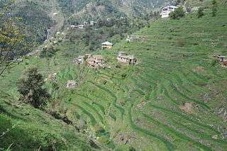 | |
 Kabal Tehsil  Kabal Tehsil | |
| Coordinates: 34°47′N 72°17′E | |
| Country | |
| Province | |
| District | Swat |
| Elevation | 845 m (2,772 ft) |
| Population | |
| • City | 420,374 |
| • Urban | 118,103 |
| • Rural | 302,271 |
| Time zone | UTC+5 (PST) |
Swat District has 7 Tehsils:[2] Tehsil Kabal, Tehsil Babuzai, Tehsil Matta, Tehsil Khwaza Khela, Tehsil Barikot, Tehsil Charbagh and Tehsil Bahrain. Each Tehsil comprises certain numbers of Union council. There are 65 Union council in district Swat, 56 rural and 09 urban.[3]
According to Khyber Pakhtunkhwa Local Government Act 2013.[4] Tehsil Kabal have following 14 Wards:[5]
- Ningolai
- Kabal
- Bara Bandai
- Kuza Bandai
- Kanju
- Hazara
- Bar Abakhail
- Kuz Abakhail
- Kala Kalay
- Deowlai
- Shah Dehrai
- Dardiyal
- Qalagay
- Totano Bandai
Tehsil Kabal is located at 34°47′N 72°17′E at an altitude of 845 metres (2,772 ft).[6]
There is an 18-hole golf ground, surrounded by calm, lush greenery and a big playground.
Nearby settlements include the villages of Kotlai and Akhun Kalai.
References
- "DISTRICT AND TEHSIL LEVEL POPULATION SUMMARY WITH REGION BREAKUP: KHYBER PAKHTUNKHWA" (PDF). Pakistan Bureau of Statistics. 2018-01-03. Archived from the original (PDF) on 2018-04-24. Retrieved 2018-04-23.
- http://lgkp.gov.pk/wp-content/uploads/2015/04/Village-Neighbourhood-Councils-Detatails-Annex-D.pdf
- https://www.hindawi.com/journals/jb/2011/368572/
- http://lgkp.gov.pk/wp-content/uploads/2013/12/Local-Government-Elections-Rules-2013.pdf
- http://lgkp.gov.pk/neighbourhood-council/
- "Falling Rain - Location of Kabbal".
| Bannu |
| ||||||||||||||||
|---|---|---|---|---|---|---|---|---|---|---|---|---|---|---|---|---|---|
| Dera Ismail Khan |
| ||||||||||||||||
| Hazara |
| ||||||||||||||||
| Kohat |
| ||||||||||||||||
| Malakand |
| ||||||||||||||||
| Mardan |
| ||||||||||||||||
| Peshawar |
| ||||||||||||||||