Jackson Township, Parke County, Indiana
Jackson Township is one of thirteen townships in Parke County, Indiana, United States. As of the 2010 census, its population was 737 and it contained 475 housing units.[2]
Jackson Township | |
|---|---|
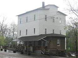 The historic roller mill in Mansfield | |
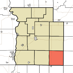 Location in Parke County | |
| Coordinates: 39°38′57″N 87°03′39″W | |
| Country | |
| State | |
| County | Parke |
| Government | |
| • Type | Indiana township |
| Area | |
| • Total | 35.76 sq mi (92.6 km2) |
| • Land | 35.57 sq mi (92.1 km2) |
| • Water | 0.19 sq mi (0.5 km2) 0.53% |
| Elevation | 614 ft (187 m) |
| Population (2010) | |
| • Total | 737 |
| • Density | 20.7/sq mi (8.0/km2) |
| Time zone | UTC-5 (Eastern (EST)) |
| • Summer (DST) | UTC-4 (EDT) |
| ZIP codes | 46135, 47834, 47837, 47872 |
| Area code(s) | 765 |
| GNIS feature ID | 453460 |
History
Jackson Township was named for Andrew Jackson, 7th President of the United States.[3]
The Big Rocky Fork Covered Bridge, Mansfield Covered Bridge, and Mansfield Roller Mill are listed on the National Register of Historic Places.[4]
Geography
According to the 2010 census, the township has a total area of 35.76 square miles (92.6 km2), of which 35.57 square miles (92.1 km2) (or 99.47%) is land and 0.19 square miles (0.49 km2) (or 0.53%) is water.[2]
Unincorporated towns
- Alma Lake at 39.608377°N 87.019457°W
- Lena at 39.6050417°N 87.1072365°W
- Mansfield at 39.676431°N 87.102236°W
(This list is based on USGS data and may include former settlements.)
Cemeteries
The township contains these two cemeteries: Jacks and Moore.
Major highways
Lakes
- Alma Lake
- Rocky Fork Lake
School districts
- Clay Community Schools
Political districts
- State House District 44
- State Senate District 38
References
- "Jackson Township, Parke County, Indiana". Geographic Names Information System. United States Geological Survey. Retrieved 2009-11-01.
- United States Census Bureau 2009 TIGER/Line Shapefiles
- IndianaMap
- "US Board on Geographic Names". United States Geological Survey. October 25, 2007. Retrieved 2017-05-09.
- "Population, Housing Units, Area, and Density: 2010 - County -- County Subdivision and Place -- 2010 Census Summary File 1". United States Census. Archived from the original on 2020-02-12. Retrieved 2013-05-10.
- History of Parke and Vermillion Counties, Indiana. B.F. Bowen & Cos. 1913. p. 187.
- "National Register Information System". National Register of Historic Places. National Park Service. July 9, 2010.
External links
- Indiana Township Association
- United Township Association of Indiana
- City-Data.com page for Jackson Township
Places adjacent to Jackson Township, Parke County, Indiana | |
|---|---|
Municipalities and communities of Parke County, Indiana, United States | ||
|---|---|---|
| Towns | Map of Indiana highlighting Parke County | |
| Townships | ||
| Unincorporated communities |
| |
| Ghost town | ||
| Footnotes | ‡This populated place also has portions in an adjacent county or counties | |
This article is issued from Wikipedia. The text is licensed under Creative Commons - Attribution - Sharealike. Additional terms may apply for the media files.