Adams Township, Parke County, Indiana
Adams Township is one of thirteen townships in Parke County, Indiana, United States. As of the 2010 census, its population was 5,825 and it contained 2,062 housing units.[2]
Adams Township | |
|---|---|
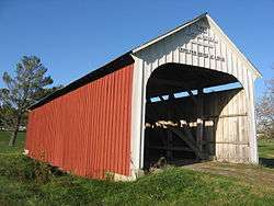 The Catlin Covered Bridge in the township's north | |
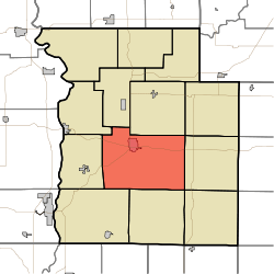 Location in Parke County | |
| Coordinates: 39°44′25″N 87°12′32″W | |
| Country | |
| State | |
| County | Parke |
| Government | |
| • Type | Indiana township |
| Area | |
| • Total | 56.07 sq mi (145.2 km2) |
| • Land | 55.8 sq mi (145 km2) |
| • Water | 0.27 sq mi (0.7 km2) 0.48% |
| Elevation | 571 ft (174 m) |
| Population (2010) | |
| • Total | 5,825 |
| • Density | 104.4/sq mi (40.3/km2) |
| Time zone | UTC-5 (Eastern (EST)) |
| • Summer (DST) | UTC-4 (EDT) |
| ZIP codes | 47832, 47872 |
| Area code(s) | 765 |
| GNIS feature ID | 453080 |
History
Adams Township was named for James Adams, a pioneer settler, but the date of the township's organization is unknown because early records were lost.[3]
The Beeson Covered Bridge, Billie Creek Covered Bridge, Catlin Covered Bridge, Crooks Covered Bridge, Leatherwood Station Covered Bridge, McAllister Covered Bridge, Neet Covered Bridge, and Sanitorium Covered Bridge were listed on the National Register of Historic Places in 1978.[4]
Geography
According to the 2010 census, the township has a total area of 56.07 square miles (145.2 km2), of which 55.8 square miles (145 km2) (or 99.52%) is land and 0.27 square miles (0.70 km2) (or 0.48%) is water.[2]
Cities, towns, villages
- Rockville (the county seat)
Unincorporated towns
- Billie Creek Village at 39.76143°N 87.201958°W
- Leatherwood at 39.751706°N 87.285293°W
- New Discovery at 39.731709°N 87.130569°W
- Piattsville at 39.704486°N 87.125847°W
(This list is based on USGS data and may include former settlements.)
Cemeteries
The township contains these four cemeteries: Hatfield, Memory Garden, Rowe and Union.
Major highways


Airports and landing strips
- Butler Field
School districts
- Rockville Community Schools
Political districts
- State House District 42
- State House District 44
- State Senate District 38
References
- "Adams Township, Parke County, Indiana". Geographic Names Information System. United States Geological Survey. Retrieved 2009-11-01.
- United States Census Bureau 2009 TIGER/Line Shapefiles
- IndianaMap
- "US Board on Geographic Names". United States Geological Survey. October 25, 2007. Retrieved 2017-05-09.
- "Population, Housing Units, Area, and Density: 2010 - County -- County Subdivision and Place -- 2010 Census Summary File 1". United States Census. Archived from the original on 2020-02-12. Retrieved 2013-05-10.
- History of Parke and Vermillion Counties, Indiana. B.F. Bowen & Cos. 1913. p. 172.
- "National Register Information System". National Register of Historic Places. National Park Service. July 9, 2010.
External links
- Indiana Township Association
- United Township Association of Indiana
- City-Data.com page for Adams Township
Places adjacent to Adams Township, Parke County, Indiana | |
|---|---|
Municipalities and communities of Parke County, Indiana, United States | ||
|---|---|---|
| Towns | Map of Indiana highlighting Parke County | |
| Townships | ||
| Unincorporated communities |
| |
| Ghost town | ||
| Footnotes | ‡This populated place also has portions in an adjacent county or counties | |