Iwamizawa, Hokkaido
Iwamizawa (岩見沢市, Iwamizawa-shi) is a city in Sorachi Subprefecture, Hokkaido, Japan. It is the capital of Sorachi Subprefecture.
Iwamizawa 岩見沢市 | |
|---|---|
 Panorama view of downtown Iwamizawa urban area | |
 Flag  Emblem | |
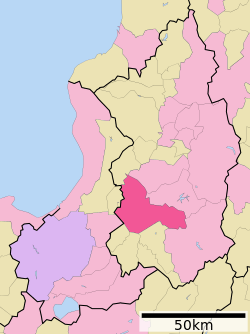 Location of Iwamizawa in Hokkaido (Sorachi Subprefecture) | |
 Iwamizawa Location in Japan | |
| Coordinates: 43°12′N 141°47′E | |
| Country | Japan |
| Region | Hokkaido |
| Prefecture | Hokkaido (Sorachi Subprefecture) |
| Government | |
| • Mayor | Satoru Matsuno |
| Area | |
| • Total | 481.10 km2 (185.75 sq mi) |
| Population (September 30, 2016) | |
| • Total | 84,127 |
| • Density | 170/km2 (450/sq mi) |
| Symbols | |
| • Tree | Kobushi Magnolia |
| • Flower | Rose |
| • Bird | Pigeon |
| Time zone | UTC+9 (JST) |
| City hall address | 1-1-1, Hatogaoka, Iwamizawa-shi, Hokkaido 068-8686 |
| Website | www |
As of September 30, 2016, the city has an estimated population of 84,127 and the density of 170 persons per km².[1] The total area is 481.10 km2 (186 sq mi).
On March 27, 2006, the town of Kurisawa, and the village of Kita (both from Sorachi District, Sorachi Subprefecture) merged into Iwamizawa.[2]
History
The name of "Iwamizawa" is derived from Japanese word "Yuamisawa" (浴澤).Yuami (浴) and sawa (澤) means "Bathing" and "A swamp".[3]
Iwamizawa was developed as a hub of land transportation around Iwamizawa Station.[2]
- 1906 - Iwamizawa village became Iwamizawa town.
- 1943 - Iwamizawa town became Iwamizawa city.
- 2006 - Kurisawa town and Kita village were merged into Iwamizawa city.
Climate
Iwamizawa has a humid continental climate (Köppen climate classification Dfb) with warm summers and cold winters. Precipitation is significant throughout the year, but is heaviest from August to October.
| Climate data for Iwamizawa, Hokkaido | |||||||||||||
|---|---|---|---|---|---|---|---|---|---|---|---|---|---|
| Month | Jan | Feb | Mar | Apr | May | Jun | Jul | Aug | Sep | Oct | Nov | Dec | Year |
| Average high °C (°F) | −2.6 (27.3) |
−1.8 (28.8) |
2.5 (36.5) |
10.5 (50.9) |
17.3 (63.1) |
21.2 (70.2) |
24.7 (76.5) |
25.9 (78.6) |
21.6 (70.9) |
15.0 (59.0) |
7.1 (44.8) |
0.6 (33.1) |
11.8 (53.3) |
| Daily mean °C (°F) | −6.2 (20.8) |
−5.8 (21.6) |
−1.5 (29.3) |
5.5 (41.9) |
11.5 (52.7) |
15.7 (60.3) |
19.7 (67.5) |
21.1 (70.0) |
16.3 (61.3) |
9.8 (49.6) |
3.2 (37.8) |
−2.7 (27.1) |
7.2 (45.0) |
| Average low °C (°F) | −10.6 (12.9) |
−10.4 (13.3) |
−5.8 (21.6) |
0.8 (33.4) |
6.2 (43.2) |
11.3 (52.3) |
16.0 (60.8) |
17.2 (63.0) |
11.6 (52.9) |
5.0 (41.0) |
−0.6 (30.9) |
−6.5 (20.3) |
2.8 (37.1) |
| Average precipitation mm (inches) | 111.5 (4.39) |
86.8 (3.42) |
59.0 (2.32) |
63.4 (2.50) |
70.3 (2.77) |
76.0 (2.99) |
95.3 (3.75) |
156.4 (6.16) |
131.4 (5.17) |
110.2 (4.34) |
116.6 (4.59) |
127.4 (5.02) |
1,204.3 (47.42) |
| Average snowfall cm (inches) | 221 (87) |
162 (64) |
72 (28) |
8 (3.1) |
0 (0) |
0 (0) |
0 (0) |
0 (0) |
0 (0) |
2 (0.8) |
81 (32) |
211 (83) |
757 (297.9) |
| Average relative humidity (%) | 80 | 78 | 75 | 70 | 71 | 78 | 81 | 81 | 78 | 76 | 77 | 80 | 77 |
| Mean monthly sunshine hours | 93.0 | 117.0 | 168.4 | 178.4 | 203.0 | 189.0 | 173.5 | 169.5 | 169.3 | 150.3 | 84.0 | 69.7 | 1,765.1 |
| Source: NOAA (1961-1990) [4] | |||||||||||||
Transportation
Rail
In the past, Horonai Line and Manji Line ran from Iwamizawa.
- Hakodate Main Line : Horomui - Kami-Horomui - Iwamizawa
- Muroran Main Line : Kurioka - Kurisawa - Shibun - Iwamizawa
Road
- Hokkaidō Expressway : Iwamizawa IC
- Route 12
Education
Universities
- Hokkaido University of Education, Iwamizawa Campus
High schools
- Hokkaido Iwamizawa Higashi High School
- Hokkaido Iwamizawa Nishi High School
- Hokkaido Iwamizawa Agricultural High School
- Hokkaido Iwamizawa Ryokuryo High School
Sister cities

References
- "Official website of Iwamizawa City" (in Japanese). Japan: Iwamizawa City. Retrieved 15 May 2017.
- The history of Iwamizawa
- The origin of the name
- "Iwamizawa Climate Normals 1961-1990". National Oceanic and Atmospheric Administration. Retrieved December 29, 2012.
- "Pocatello, Idaho". Sister Cities International. Retrieved 19 April 2014.
- Fostering International Exchange in Iwamizawa
External links
| Wikimedia Commons has media related to Iwamizawa, Hokkaido. |
- Official Website (in Japanese)
- Sightseeing information website (in Japanese)
Sapporo (capital) | ||||||||||
| ||||||||||
| ||||||||||
| ||||||||||
| ||||||||||
| ||||||||||
| ||||||||||
| ||||||||||
| ||||||||||
| ||||||||||
| ||||||||||
| ||||||||||
| ||||||||||
| ||||||||||
| ||||||||||
| Authority control |
|
|---|