Barre, Massachusetts
Barre /ˈbæri/ is a town in Worcester County, Massachusetts, United States. The population was 5,398 at the 2010 census.
Barre, Massachusetts | |
|---|---|
 Barre Town Hall | |
 Seal | |
| Motto(s): "Tranquil and Alert" | |
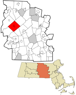 Location in Worcester County and the state of Massachusetts. | |
| Coordinates: 42°25′22″N 72°06′20″W | |
| Country | United States |
| State | Massachusetts |
| County | Worcester |
| Settled | 1720 |
| Incorporated | 1774 |
| Government | |
| • Type | Open town meeting |
| • Town Administrator | Heather Munroe (Interim) |
| Area | |
| • Total | 44.6 sq mi (115.5 km2) |
| • Land | 44.3 sq mi (114.8 km2) |
| • Water | 0.3 sq mi (0.7 km2) |
| Elevation | 886 ft (270 m) |
| Population (2010) | |
| • Total | 5,398 |
| • Density | 120/sq mi (47/km2) |
| Time zone | UTC-5 (Eastern) |
| • Summer (DST) | UTC-4 (Eastern) |
| ZIP code | 01005 |
| Area code(s) | 351 / 978 Exchange code = 355 |
| FIPS code | 25-03740 |
| GNIS feature ID | 0619475 |
| Website | www.townofbarre.com |
History
Originally called the Northwest District of Rutland, it was first settled in 1720. The town was incorporated as a district on June 17, 1774, as Hutchinson after Thomas Hutchinson, colonial governor of Massachusetts. Eventually along with 41 other districts in the state, they were all incorporated on August 23, 1775 by the Massachusetts Court. The next year on November 7, 1776, it was renamed Barre in honor of Colonel Isaac Barré, an Irish-born MP who was a champion of American Independence. Starting in the 1800s, the Boston, Barre and Gardner Railroad provided rail service to the town.
Geography
According to the United States Census Bureau, the town has a total area of 44.6 square miles (116 km2), of which 44.3 square miles (115 km2) is land and 0.3 square miles (0.78 km2), or 0.63%, is water. Barre is drained by the Ware River.
Barre is bordered by Hubbardston to the northeast, Rutland and Oakham to the southeast, New Braintree to the south, Hardwick to the southwest, Petersham to the northwest, and a small portion of Phillipston to the north.
Demographics
| Historical population | ||
|---|---|---|
| Year | Pop. | ±% |
| 1850 | 2,976 | — |
| 1860 | 2,973 | −0.1% |
| 1870 | 2,572 | −13.5% |
| 1880 | 2,419 | −5.9% |
| 1890 | 2,239 | −7.4% |
| 1900 | 2,059 | −8.0% |
| 1910 | 2,957 | +43.6% |
| 1920 | 3,357 | +13.5% |
| 1930 | 3,510 | +4.6% |
| 1940 | 3,528 | +0.5% |
| 1950 | 3,406 | −3.5% |
| 1960 | 3,479 | +2.1% |
| 1970 | 3,825 | +9.9% |
| 1980 | 4,102 | +7.2% |
| 1990 | 4,546 | +10.8% |
| 2000 | 5,113 | +12.5% |
| 2010 | 5,398 | +5.6% |
| * = population estimate. Source: United States Census records and Population Estimates Program data.[1][2][3][4][5][6][7][8][9][10] | ||
As of the census[11] of 2000, there were 5,113 people, 1,889 households, and 1,377 families residing in the town. The population density was 115.3 people per square mile (44.5/km2). There were 1,988 housing units at an average density of 44.8 per square mile (17.3/km2). The racial makeup of the town was 97.63% White, 0.51% Black or African American, 0.10% Native American, 0.33% Asian, 0.29% from other races, and 1.13% from two or more races. 0.80% of the population were Hispanic or Latino of any race.
There were 1,889 households, out of which 36.5% had children under the age of 18 living with them, 58.9% were married couples living together, 9.8% had a female householder with no husband present, and 27.1% were non-families. 22.8% of all households were made up of individuals, and 10.3% had someone living alone who was 65 years of age or older. The average household size was 2.69 and the average family size was 3.17.
In the town, the population was spread out, with 28.4% under the age of 18, 5.7% from 18 to 24, 31.0% from 25 to 44, 22.3% from 45 to 64, and 12.7% who were 65 years of age or older. The median age was 37 years. For every 100 females, there were 96.1 males. For every 100 females age 18 and over, there were 95.7 males.
The median income for a household in the town was $50,553, and the median income for a family was $56,069. Males had a median income of $40,284 versus $29,250 for females. The per capita income for the town was $20,476. 3.4% of the population and 1.2% of families were below the poverty line. Out of the total population, 1.5% of those under the age of 18 and 2.6% of those 65 and older were living below the poverty line.
Education
Barre is home to the Quabbin Regional High School[12] and to Ruggles Lane Elementary School.[13] It also home to the administrative offices (including the office of the superintendent) of the Quabbin Regional School District.[14]
At one time, extending from 1840 into the twentieth century, it was home to the Barre Massachusetts Institution for the Education of Feeble Minded Youth.[15]
Barre is home to Stetson School.[16]
Government
| County-level state agency heads | |
|---|---|
| Clerk of Courts: | Dennis P. McManus (D) |
| District Attorney: | Joe Early Jr. (D) |
| Register of Deeds: | Katie Toomey (D) |
| Register of Probate: | Stephanie Fattman (R) |
| County Sheriff: | Lew Evangelidis (R) |
| State government | |
| State Representative(s): | Donnie Berthiaume (R) |
| State Senator(s): | Anne M. Gobi (D) |
| Governor's Councilor(s): | Jen Caissie (R) |
| Federal government | |
| U.S. Representative(s): | James P. McGovern (D-2nd District), |
| U.S. Senators: | Elizabeth Warren (D), Ed Markey (D) |
Sites of interest
- Barre Historical Society & Museum[17]
- Barre Players Theater[18]
- Insight Meditation Society[19]
- Russell's Fossil Museum[20]
Notable people
- David Oliver Allen, missionary and author
- Stephen Brewer, state senator
- Ebenezer Childs, pioneer and legislator
- Timothy Jenkins, congressman
- Walker Lewis, black abolitionist, Masonic Grand Master of African Grand Lodge #1, and Mormon Elder
- John Murray (Massachusetts), Representative to the Great and General Court of the Province of Massachusetts Bay for Rutland's Northwest District
- Joseph B. Plummer, general
- Jacob Riis, journalist, author of How the Other Half Lives
- Daniel Ruggles, Confederate general
- Andrew M. Donahue, world wide mountaineer and explorer.
- Culleen M. Filosi (McCluskey), global pioneer on gluten awareness, spent 17 consecutive years as a college student
References
- "Total Population (P1), 2010 Census Summary File 1". American FactFinder, All County Subdivisions within Massachusetts. United States Census Bureau. 2010.
- "Massachusetts by Place and County Subdivision - GCT-T1. Population Estimates". United States Census Bureau. Retrieved July 12, 2011.
- "1990 Census of Population, General Population Characteristics: Massachusetts" (PDF). US Census Bureau. December 1990. Table 76: General Characteristics of Persons, Households, and Families: 1990. 1990 CP-1-23. Retrieved July 12, 2011.
- "1980 Census of the Population, Number of Inhabitants: Massachusetts" (PDF). US Census Bureau. December 1981. Table 4. Populations of County Subdivisions: 1960 to 1980. PC80-1-A23. Retrieved July 12, 2011.
- "1950 Census of Population" (PDF). Bureau of the Census. 1952. Section 6, Pages 21-10 and 21-11, Massachusetts Table 6. Population of Counties by Minor Civil Divisions: 1930 to 1950. Retrieved July 12, 2011.
- "1920 Census of Population" (PDF). Bureau of the Census. Number of Inhabitants, by Counties and Minor Civil Divisions. Pages 21-5 through 21-7. Massachusetts Table 2. Population of Counties by Minor Civil Divisions: 1920, 1910, and 1920. Retrieved July 12, 2011.
- "1890 Census of the Population" (PDF). Department of the Interior, Census Office. Pages 179 through 182. Massachusetts Table 5. Population of States and Territories by Minor Civil Divisions: 1880 and 1890. Retrieved July 12, 2011.
- "1870 Census of the Population" (PDF). Department of the Interior, Census Office. 1872. Pages 217 through 220. Table IX. Population of Minor Civil Divisions, &c. Massachusetts. Retrieved July 12, 2011.
- "1860 Census" (PDF). Department of the Interior, Census Office. 1864. Pages 220 through 226. State of Massachusetts Table No. 3. Populations of Cities, Towns, &c. Retrieved July 12, 2011.
- "1850 Census" (PDF). Department of the Interior, Census Office. 1854. Pages 338 through 393. Populations of Cities, Towns, &c. Retrieved July 12, 2011.
- "U.S. Census website". United States Census Bureau. Retrieved 2008-01-31.
- Location of Quabbin Regional High School via Google Maps Google Maps. Retrieved on 14 January 2015
- "Google Maps".
- "Archived copy". Archived from the original on 2015-02-05. Retrieved 2015-01-14.CS1 maint: archived copy as title (link)
- "disability history museum--Private Institution For The Education Of Feeble-Minded Youth. Barre, Massachusetts. Twenty-Fifth Biennial Report". Archived from the original on 2015-06-08.
- "Stetson School".
- "View Museum Info". Archived from the original on 2011-06-09.
- "Barre Players Theater, Barre, Massachusetts Home Page". Archived from the original on 2013-11-12.
- "Insight Meditation Society". Archived from the original on 2015-08-18.
- "Archived copy". Archived from the original on 2012-02-17. Retrieved 2009-03-03.CS1 maint: archived copy as title (link)
External links
| Wikimedia Commons has media related to Barre, Massachusetts. |
| Authority control |
|
|---|