Hua Sai District
Hua Sai (Thai: หัวไทร, pronounced [hǔa̯ sāj]) is a district (amphoe) in the southeastern part of Nakhon Si Thammarat Province, southern Thailand.
Hua Sai หัวไทร | |
|---|---|
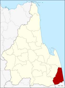 District location in Nakhon Si Thammarat Province | |
| Coordinates: 8°2′24″N 100°16′30″E | |
| Country | Thailand |
| Province | Nakhon Si Thammarat |
| Seat | Hua Sai |
| Area | |
| • Total | 417.733 km2 (161.288 sq mi) |
| Population (2005) | |
| • Total | 68,863 |
| • Density | 164.8/km2 (427/sq mi) |
| Time zone | UTC+7 (ICT) |
| Postal code | 80170 |
| Geocode | 8016 |
Geography
Neighboring districts are (from the south clockwise): Ranot of Songkhla Province; Khuan Khanun and Pa Phayom of Phattalung Province; Cha-uat, Chian Yai, and Pak Phanang of Nakhon Si Thammarat Province. To the east is the Gulf of Thailand.
History
The district was established in 1904, then named Khao Phang Krai (เขาพังไกร), as the administrative center was in tambon Khao Phang Krai. When the center was moved in 1906 to tambon Hua Sai, the district was renamed accordingly. In 1924 the district was reduced to a minor district (king amphoe) under Pak Phanang District. In the same year the district office was moved to its present location in village eight of tambon Hua Sai. In 1937 the district regained full district status.[1]
Administration
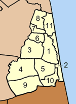
The district is divided into 11 sub-districts (tambons), which are further subdivided into 99 villages (mubans). Hua Sai is a township (thesaban tambon) which covers parts of tambons Hua Sai and Na Saton. There are a further 11 tambon administrative organizations (TAO).
|
 |
References
- ประกาศสำนักนายกรัฐมนตรี เรื่อง ตั้งอำเภอหัวไทร จังหวัดนครศรีธรรมราช (PDF). Royal Gazette (in Thai). 54 (0 ง): 850–851. August 2, 1937.
External links
- amphoe.com
- http://www.huasai.go.th Hua Sai TAO (Thai)