Nopphitam District
Nopphitam (Thai: นบพิตำ, pronounced [nóp.pʰí(ʔ).tām]) is a district (amphoe) of Nakhon Si Thammarat Province, southern Thailand.
Nopphitam นบพิตำ | |
|---|---|
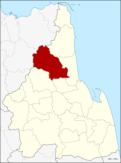 District location in Nakhon Si Thammarat Province | |
| Coordinates: 8°43′10″N 99°45′6″E | |
| Country | Thailand |
| Province | Nakhon Si Thammarat |
| Seat | Nopphitam |
| Area | |
| • Total | 720.156 km2 (278.054 sq mi) |
| Population (2005) | |
| • Total | 29,670 |
| • Density | 41.2/km2 (107/sq mi) |
| Time zone | UTC+7 (ICT) |
| Postal code | 80160 |
| Geocode | 8021 |
History
The district was created on 1 April 1995 by splitting off the four western tambons from Tha Sala District.[1]
On 15 May 2007, all 81 minor districts were upgraded to full districts.[2] On 24 August, the upgrade became official.[3]
Geography
Neighboring districts are (from the northeast clockwise): Sichon, Tha Sala, Phrom Khiri and Phipun of Nakhon Si Thammarat Province and Ban Na San and Kanchanadit of Surat Thani Province.
Nopphitam contains the northernmost part of the Khao Luang National Park, protecting a large part of the Nakhon Si Thammarat mountain range.
Administration
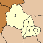
The district is divided into four sub-districts (tambons), which are further subdivided into 38 villages (mubans). There are no municipal (thesaban) areas, and four tambon administrative organizations (TAO).
|
 |
References
- ประกาศกระทรวงมหาดไทย เรื่อง แบ่งเขตท้องที่อำเภอท่าศาลา จังหวัดนครศรีธรรมราช ตั้งเป็นกิ่งอำเภอนบพิตำ (PDF). Royal Gazette (in Thai). 112 (Special 9 ง): 53. March 22, 2007.
- แถลงผลการประชุม ครม. ประจำวันที่ 15 พ.ค. 2550. Manager Online (in Thai).
- พระราชกฤษฎีกาตั้งอำเภอฆ้องชัย...และอำเภอเหล่าเสือโก้ก พ.ศ. ๒๕๕๐ (PDF). Royal Gazette (in Thai). 124 (46 ก): 14–21. August 24, 2007.