Pa Phayom District
Pa Phayom (Thai: ป่าพะยอม, pronounced [pàː pʰā.jɔ̄ːm]) is the northernmost district (amphoe) of Phatthalung Province, southern Thailand.
Pa Phayom ป่าพะยอม | |
|---|---|
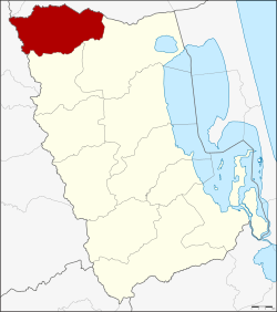 District location in Phatthalung Province | |
| Coordinates: 7°50′24″N 99°55′6″E | |
| Country | Thailand |
| Province | Phatthalung |
| Seat | Pa Phayom |
| Area | |
| • Total | 386.4 km2 (149.2 sq mi) |
| Population (2005) | |
| • Total | 32,280 |
| • Density | 83.5/km2 (216/sq mi) |
| Time zone | UTC+7 (ICT) |
| Postal code | 93210 |
| Geocode | 9310 |
Geography
Neighboring districts are (from the southeast clockwise) Khuan Khanun, Si Banphot of Phattalung Province, Huai Yot of Trang Province and Cha-uat of Nakhon Si Thammarat Province.
History
The minor district (king amphoe) was established on 19 January 1990, when four tambons were split off from Khuan Khanun District.[1] It was upgraded to a full district on 7 September 1995.[2]
Administration
The district is divided into four sub-districts (tambons), which are further subdivided into 39 villages (mubans). There are no municipal (thesabans). There are four tambon administrative organizations (TAO).
| No. | Name | Thai name | Villages | Pop. | |
|---|---|---|---|---|---|
| 1. | Pa Phayom | ป่าพะยอม | 7 | 5,764 | |
| 2. | Lan Khoi | ลานข่อย | 9 | 7,594 | |
| 3. | Ko Tao | เกาะเต่า | 13 | 11,281 | |
| 4. | Ban Phrao | บ้านพร้าว | 10 | 7,641 |
References
- ประกาศกระทรวงมหาดไทย เรื่อง แบ่งเขตท้องที่อำเภอควนขนุน จังหวัดพัทลุง ตั้งเป็นกิ่งอำเภอป่าพะยอม (PDF). Royal Gazette (in Thai). 107 (25 ง): 1355. February 13, 1990.
- พระราชกฤษฎีกาตั้งอำเภอด่านมะขามเตี้ย อำเภอแก่งหางแมว อำเภอภักดีชุมพล อำเภอเวียงแก่น อำเภอแม่วาง อำเภอถ้ำพรรณรา อำเภอบ่อเกลือ อำเภอโนนสุวรรณ อำเภอห้วยราช อำเภอแม่ลาน อำเภอบางแก้ว อำเภอป่าพะยอม อำเภอหนองม่วงไข่ อำเภอยางสีสุราช อำเภอจังหาร อำเภอบ้านธิ อำเภอภูสิงห์ อำเภอบางกล่ำ อำเภอวังม่วง และอำเภอนายูง พ.ศ. ๒๕๓๘ (PDF). Royal Gazette (in Thai). 112 (32 ก): 1–3. August 8, 1995.
This article is issued from Wikipedia. The text is licensed under Creative Commons - Attribution - Sharealike. Additional terms may apply for the media files.