Ron Phibun District
Ron Phibun (Thai: ร่อนพิบูลย์, pronounced [rɔ̂n pʰí(ʔ).būːn]) is a district (amphoe) in the southern part of Nakhon Si Thammarat Province, southern Thailand.
Ron Phibun ร่อนพิบูลย์ | |
|---|---|
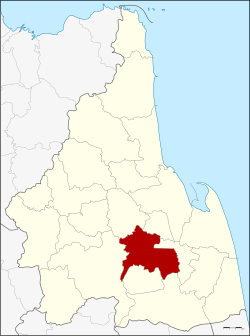 District location in Nakhon Si Thammarat Province | |
| Coordinates: 8°10′48″N 99°51′18″E | |
| Country | Thailand |
| Province | Nakhon Si Thammarat |
| Seat | Ron Phibun |
| Area | |
| • Total | 335.5 km2 (129.5 sq mi) |
| Population (2005) | |
| • Total | 82,754 |
| • Density | 246.7/km2 (639/sq mi) |
| Time zone | UTC+7 (ICT) |
| Postal code | 80130 |
| Geocode | 8013 |
Geography
Neighboring districts are (from the west clockwise): Thung Song, Lan Saka, Phra Phrom, Chaloem Phra Kiat, Cha-uat, and Chulabhorn of Nakhon Si Thammarat Province.
Administration
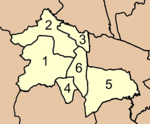
The district is divided into six sub-districts (tambons), which are further subdivided into 61 villages (mubans). There are three townships (thesaban tambons). Ron Phibun and Hin Tok both covers parts of the same-named tambons, and Khao Chum Thong covers the whole tambon Khuan Koei. There are a further six tambon administrative organizations (TAO).
|
 |
References
External links
This article is issued from Wikipedia. The text is licensed under Creative Commons - Attribution - Sharealike. Additional terms may apply for the media files.