History of geodesy
Geodesy (/dʒiːˈɒdɨsi/), also named geodetics, is the scientific discipline that deals with the measurement and representation of the Earth. The history of geodesy began in pre-scientific antiquity and blossomed during the Age of Enlightenment.
| Geodesy | ||||||||||||||||||||||||||
|---|---|---|---|---|---|---|---|---|---|---|---|---|---|---|---|---|---|---|---|---|---|---|---|---|---|---|
 | ||||||||||||||||||||||||||
|
Fundamentals |
||||||||||||||||||||||||||
|
Concepts |
||||||||||||||||||||||||||
|
Technologies
|
||||||||||||||||||||||||||
|
Standards (history)
|
||||||||||||||||||||||||||
Early ideas about the figure of the Earth held the Earth to be flat (see flat Earth), and the heavens a physical dome spanning over it. Two early arguments for a spherical Earth were that lunar eclipses were seen as circular shadows which could only be caused by a spherical Earth, and that Polaris is seen lower in the sky as one travels South.
Hellenic world
The early Greeks, in their speculation and theorizing, ranged from the flat disc advocated by Homer to the spherical body postulated by Pythagoras. Pythagoras's idea was supported later by Aristotle.[2] Pythagoras was a mathematician and to him the most perfect figure was a sphere. He reasoned that the gods would create a perfect figure and therefore the Earth was created to be spherical in shape. Anaximenes, an early Greek philosopher, believed strongly that the Earth was rectangular in shape.
Since the spherical shape was the most widely supported during the Greek Era, efforts to determine its size followed. Aristotle reported that mathematicians had calculated the circumference of the Earth (which is slightly over 40,000 km) to be 400,000 stadia (between 62,800 and 74,000 km or 46,250 and 39,250 mi) while Archimedes stated an upper bound of 3,000,000 stadia (483,000 km or 300,000 mi) using the Hellenic stadion which scholars generally take to be 185 meters or 1⁄9 of a geographical mile.
Hellenistic world
In Egypt, a Greek scholar and philosopher, Eratosthenes (276 BCE – 195 BCE) measured Earth's circumference with great precision.[3] He estimated that the meridian has a length of 252,000 stadia, with an error on the real value between -2.4% and +0.8% (assuming a value for the stadion between 155 and 160 metres).[3] Eratosthenes described his technique in a book entitled On the measure of the Earth, which has not been preserved.

Eratosthenes' method to calculate the Earth's circumference has been lost; what has been preserved is the simplified version described by Cleomedes to popularise the discovery.[4] Cleomedes invites his reader to consider two Egyptian cities, Alexandria and Syene, modern Assuan:
- Cleomedes assumes that the distance between Syene and Alexandria was 5,000 stadia (a figure that was checked yearly by professional bematists, mensores regii);[5]
- he assumes the simplified (but false) hypothesis that Syene was precisely on the Tropic of Cancer, saying that at local noon on the summer solstice the Sun was directly overhead;
- he assumes the simplified (but false) hypothesis that Syene and Alexandria are on the same meridian.
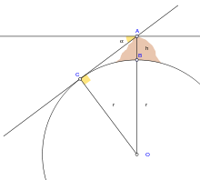
Under the previous assumptions, says Cleomedes, you can measure the Sun's angle of elevation at noon of the summer solstice in Alexandria, by using a vertical rod (a gnomon) of known length and measuring the length of its shadow on the ground; it is then possible to calculated the angle of the Sun's rays, which he claims to be about 7°, or 1/50th the circumference of a circle. Taking the Earth as spherical, the Earth's circumference would be fifty times the distance between Alexandria and Syene, that is 250,000 stadia. Since 1 Egyptian stadium is equal to 157.5 metres, the result is 39,375 km, which is 1.4% less than the real number, 39,941 km.
Eratosthenes' method was actually more complicated, as stated by the same Cleomedes, whose purpose was to present a simplified version of the one described in Eratosthenes' book. The method was based on several surveying trips conducted by professional bematists, whose job was to precisely measure the extent of the territory of Egypt for agricultural and taxation-related purposes.[3] Furthermore, the fact that Eratosthenes' measure corresponds precisely to 252,000 stadia might be intentional, since it is a number that can be divided by all natural numbers from 1 to 10: some historians believe that Eratosthenes changed from the 250,000 value written by Cleomedes to this new value to simplify calculations;[6] other historians of science, on the other side, believe that Eratosthenes introduced a new length unit based on the length of the meridian, as stated by Pliny, who writes about the stadion “according to Eratosthenes' ratio”.[3][7]
A parallel later ancient measurement of the size of the Earth was made by another Greek scholar, Posidonius. He noted that the star Canopus was hidden from view in most parts of Greece but that it just grazed the horizon at Rhodes. Posidonius is supposed to have measured the angular elevation of Canopus at Alexandria and determined that the angle was 1/48 of circle. He used a distance from Alexandria to Rhodes, 5000 stadia, and so he computed the Earth's circumference in stadia as 48 times 5000 = 240,000.[8] Some scholars see these results as luckily semi-accurate due to cancellation of errors. But since the Canopus observations are both mistaken by over a degree, the "experiment" may be not much more than a recycling of Eratosthenes's numbers, while altering 1/50 to the correct 1/48 of a circle. Later, either he or a follower appears to have altered the base distance to agree with Eratosthenes's Alexandria-to-Rhodes figure of 3750 stadia since Posidonius' final circumference was 180,000 stadia, which equals 48×3750 stadia.[9] The 180,000 stadia circumference of Posidonius is suspiciously close to that which results from another method of measuring the earth, by timing ocean sunsets from different heights, a method which is inaccurate due to horizontal atmospheric refraction.
The above mentioned larger and smaller sizes of the Earth were those used by Claudius Ptolemy at different times, 252,000 stadia in his Almagest and 180,000 stadia in his later Geographia. His mid-career conversion resulted in the latter work's systematic exaggeration of degree longitudes in the Mediterranean by a factor close to the ratio of the two seriously differing sizes discussed here, which indicates that the conventional size of the earth was what changed, not the stadion.[10]
Ancient India
The Indian mathematician Aryabhata (AD 476–550) was a pioneer of mathematical astronomy. He describes the earth as being spherical and that it rotates on its axis, among other things in his work Āryabhaṭīya. Aryabhatiya is divided into four sections. Gitika, Ganitha (mathematics), Kalakriya (reckoning of time) and Gola (celestial sphere). The discovery that the earth rotates on its own axis from west to east is described in Aryabhatiya (Gitika 3,6; Kalakriya 5; Gola 9,10;).[11] For example, he explained the apparent motion of heavenly bodies is only an illusion (Gola 9), with the following simile;
- Just as a passenger in a boat moving downstream sees the stationary (trees on the river banks) as traversing upstream, so does an observer on earth see the fixed stars as moving towards the west at exactly the same speed (at which the earth moves from west to east.)
Aryabhatiya also estimates the circumference of Earth. He gave the circumference of the earth as 4967 yojanas and its diameter as 1581+1/24 yojanas. The length of a yojana varies considerably between sources; assuming a yojana to be 13 km (8 miles) this gives as circumference nearly 65000 km (or 40000 miles)[12]
Roman Empire
In late antiquity, such widely read encyclopedists as Macrobius and Martianus Capella (both 5th century AD) discussed the circumference of the sphere of the Earth, its central position in the universe, the difference of the seasons in northern and southern hemispheres, and many other geographical details.[13] In his commentary on Cicero's Dream of Scipio, Macrobius described the Earth as a globe of insignificant size in comparison to the remainder of the cosmos.[13]
Islamic world
The Muslim scholars, who held to the spherical Earth theory, used it to calculate the distance and direction from any given point on the earth to Mecca. This determined the Qibla, or Muslim direction of prayer. Muslim mathematicians developed spherical trigonometry which was used in these calculations.[14]
Around AD 830 Caliph al-Ma'mun commissioned a group of astronomers to test Eratosthenes' calculation of one degree of latitude by using a rope to measure the distance travelled due north or south on flat desert land until they reached a place where the altitude of the North Pole had changed by one degree. The measured value is described in different sources as 66 2/3 miles, 56.5 miles, and 56 miles. The figure Alfraganus used based on these measurements was 56 2/3 miles, giving an Earth circumference of 24,000 miles (38,625 km).[15]
In contrast to his predecessors who measured the Earth's circumference by sighting the Sun simultaneously from two different locations, Abu Rayhan al-Biruni (973–1048) developed a new method of using trigonometric calculations based on the angle between a plain and mountain top which yielded simpler measurements of the Earth's circumference and made it possible for it to be measured by a single person from a single location.[16][17][18] Al-Biruni's method's motivation was to avoid "walking across hot, dusty deserts" and the idea came to him when he was on top of a tall mountain in India (present day Pind Dadan Khan, Pakistan).[18] From the top of the mountain, he sighted the dip angle which, along with the mountain's height (which he calculated beforehand), he applied to the law of sines formula.[17][18] While this was an ingenious new method, Al-Biruni was not aware of atmospheric refraction. To get the true dip angle the measured dip angle needs to be corrected by approximately 1/6, meaning that even with perfect measurement his estimate could only have been accurate to within about 20%.[19]
Muslim astronomers and geographers were aware of magnetic declination by the 15th century, when the Egyptian astronomer 'Abd al-'Aziz al-Wafa'i (d. 1469/1471) measured it as 7 degrees from Cairo.[20]
Medieval Europe
Revising the figures attributed to Posidonius, another Greek philosopher determined 18,000 miles (29,000 km) as the Earth's circumference. This last figure was promulgated by Ptolemy through his world maps. The maps of Ptolemy strongly influenced the cartographers of the Middle Ages. It is probable that Christopher Columbus, using such maps, was led to believe that Asia was only 3,000 or 4,000 miles (4,800 or 6,400 km) west of Europe.
Ptolemy's view was not universal, however, and chapter 20 of Mandeville's Travels (c. 1357) supports Eratosthenes' calculation.
It was not until the 16th century that his concept of the Earth's size was revised. During that period the Flemish cartographer, Mercator, made successive reductions in the size of the Mediterranean Sea and all of Europe which had the effect of increasing the size of the earth.
Early modern period
The invention of the telescope and the theodolite and the development of logarithm tables allowed exact triangulation and grade measurement.
Europe
In the Carolingian era, scholars discussed Macrobius's view of the antipodes. One of them, the Irish monk Dungal, asserted that the tropical gap between our habitable region and the other habitable region to the south was smaller than Macrobius had believed.[21]
In 1505 the cosmographer and explorer Duarte Pacheco Pereira calculated the value of the degree of the meridian arc with a margin of error of only 4%, when the current error at the time varied between 7 and 15%.[22]
Jean Picard performed the first modern meridian arc measurement in 1669–1670. He measured a baseline using wooden rods, a telescope (for his angular measurements), and logarithms (for computation). Jacques Cassini later continued Picard's arc (Paris meridian arc) northward to Dunkirk and southward to the Spanish border. Cassini divided the measured arc into two parts, one northward from Paris, another southward. When he computed the length of a degree from both chains, he found that the length of one degree of latitude in the northern part of the chain was shorter than that in the southern part (see illustration).
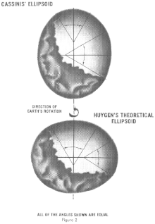
This result, if correct, meant that the earth was not a sphere, but a prolate spheroid (taller than wide). However, this contradicted computations by Isaac Newton and Christiaan Huygens. In 1659, Christiaan Huygens was the first to derive the now standard formula for the centripetal force in his work De vi centrifuga. The formula played a central role in classical mechanics and became known as the second of Newton's laws of motion. Newton's theory of gravitation combined with the rotation of the Earth predicted the Earth to be an oblate spheroid (wider than tall), with a flattening of 1:230.[23]
The issue could be settled by measuring, for a number of points on earth, the relationship between their distance (in north-south direction) and the angles between their zeniths. On an oblate Earth, the meridional distance corresponding to one degree of latitude will grow toward the poles, as can be demonstrated mathematically.
The French Academy of Sciences dispatched two expeditions. One expedition (1736–37) under Pierre Louis Maupertuis was sent to Torne Valley (near the Earth's northern pole). The second mission (1735–44) under Pierre Bouguer was sent to what is modern-day Ecuador, near the equator. Their measurements demonstrated an oblate Earth, with a flattening of 1:210. This approximation to the true shape of the Earth became the new reference ellipsoid.
In 1787 the first precise trigonometric survey to be undertaken within Britain was the Anglo-French Survey. Its purpose was to link the Greenwich and Paris' observatories.[24] The survey is very significant as the forerunner of the work of the Ordnance Survey which was founded in 1791, one year after William Roy's death.
Between 1792 and 1798 Pierre Méchain and Jean-Baptiste Delambre surveyed the Paris meridian arc between Dunkirk and Barcelona. They extrapolated from this measurement the distance from the North Pole to the Equator which was 5 130 740 toises. As the metre had to be equal to one ten-million of this distance, it was defined as 0,513074 toises or 443,296 lignes of the Toise of Peru (see below).[25]
Asia and Americas
In South America Bouguer noticed, as did George Everest in the 19th century Great Trigonometric Survey of India, that the astronomical vertical tended to be pulled in the direction of large mountain ranges, due to the gravitational attraction of these huge piles of rock. As this vertical is everywhere perpendicular to the idealized surface of mean sea level, or the geoid, this means that the figure of the Earth is even more irregular than an ellipsoid of revolution. Thus the study of the "undulation of the geoid" became the next great undertaking in the science of studying the figure of the Earth.
19th century
In the late 19th century the Mitteleuropäische Gradmessung (Central European Arc Measurement) was established by several central European countries and a Central Bureau was set up at the expense of Prussia, within the Geodetic Institute at Berlin.[26] One of its most important goals was the derivation of an international ellipsoid and a gravity formula which should be optimal not only for Europe but also for the whole world. The Mitteleuropäische Gradmessung was an early predecessor of the International Association of Geodesy (IAG) one of the constituent sections of the International Union of Geodesy and Geophysics (IUGG) which was founded in 1919.[27][28]
Geodesy and standards of length
In the 18th century geodetic surveys found practical applications in French cartography and in the Anglo-French Survey (1784-1790), which aimed to connect Paris and Greenwich Observatories and led to the Principal Triangulation of Great Britain.[29][30]
Soon after the Anglo-French Survey, the French Academy of Sciences commissioned an expedition led by Jean Baptiste Joseph Delambre and Pierre Méchain, lasting from 1792 to 1799, which attempted to accurately measure the distance between a belfry in Dunkerque and Montjuïc castle in Barcelona at the longitude of Paris Panthéon. A new unit of length, the metre was introduced – defined as one ten-millionth of the shortest distance from the North Pole to the equator passing through Paris, assuming an Earth's flattening of 1/334.[30][31]
In 1811 Ferdinand Rudolph Hassler was selected to direct the U. S. coast survey, and sent on a mission to France and England to procure instruments and standards of measurement.[32] The unit of length to which all distances measured in the U. S. coast survey were referred is the French metre, of which Ferdinand Rudolph Hassler had brought a copy in the United States in 1805.[33][34]
In the early 19th century, the Paris meridian's arc was recalculated with greater precision between Shetland and the Balearic Islands by the French astronomers François Arago and Jean-Baptiste Biot. In 1821 they published their work as a fourth volume following the three volumes of "Bases du système métrique décimal ou mesure de l'arc méridien compris entre les parallèles de Dunkerque et Barcelone" (Basis for the decimal metric system or measurement of the meridian arc comprised between Dunkirk and Barcelona) by Delambre and Méchain.[35]
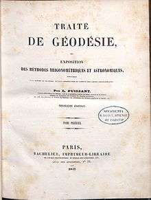
Louis Puissant declared in 1836 in front of the French Academy of Sciences that Delambre and Méchain had made an error in the measurement of the French meridian arc. Some thought that the base of the metric system could be attacked by pointing out some errors that crept into the measurement of the two French scientists. Méchain had even noticed an inaccuracy he did not dare to admit. That is why from 1861 to 1866, Antoine Yvon Villarceau checked the geodesic opérations in eight points of the meridian arc. Some of the errors in the operations of Delambre and Méchain were corrected. In 1866, at the conference of the International Association of Geodesy in Neuchâtel Carlos Ibáñez e Ibáñez de Ibero announced Spain's contribution to the measurement of the French meridian arc. In 1870, François Perrier was in charge of resuming the triangulation between Dunkirk and Barcelona. This new survey of the Paris meridian arc, named West Europe-Africa Meridian-arc by Alexander Ross Clarke, was undertaken in France and in Algeria under the direction of François Perrier from 1870 to his death in 1888. Jean-Antonin-Léon Bassot completed the task in 1896. According to the calculations made at the central bureau of the international association on the great meridian arc extending from the Shetland Islands, through Great Britain, France and Spain to El Aghuat in Algeria, the Earth equatorial radius was 6377935 metres, the ellipticity being assumed as 1/299.15.
In 1860, the Russian Government at the instance of Otto Sturves invited the Governments of Belgium, France, Prussia and England to connect their triangulations in order to measure the length of an arc of parallel in latitude 52° and to test the accuracy of the figure and dimensions of the Earth, as derived from the measurements of arc of meridian. In order to combine the measurements, it was necessary to compare the geodetic standards of length used in the different countries. The British Government invited those of France, Belgium, Prussia, Russia, India, Australia, Austria, Spain, United States and Cape of Good Hope to send their standards to the Ordnance Survey office in Southampton. Notably the standards of France, Spain and United States were based on the metric system, whereas those of Prussia, Belgium and Russia where calibrated against the toise, of which the oldest physical representative was the Toise of Peru. The Toise of Peru had been constructed in 1735 for Bouguer and De La Condamine as their standard of reference in the French Geodesic Mission, conducted in actual Ecuador from 1735 to 1744 in collaboration with the Spanish officers Jorge Juan and Antonio de Ulloa.
Alexander Ross Clarke and Henry James published the first results of the standards' comparisons in 1867. The same year Russia, Spain and Portugal joined the "Europäische Gradmessung" and the General Conference of the association proposed the metre as a uniform length standard for the Arc Measurement and recommended the establishment of an International Bureau of Weights and Measures.
The Europäische Gradmessung decided the creation of an international geodetic standard at the General Conference held in Paris in 1875. The Metre Convention was signed in 1875 in Paris and the International Bureau of Weights and Measures was created under the supervision of the International Committee for Weights and Measures. The first president of the International Committee for Weights and Measures was the Spanish geodesist Carlos Ibáñez e Ibáñez de Ibero. He also was the president of the Permanent Commission of the "Europäische Gradmessung" from 1874 to 1886. In 1886 the association changed name for the International Geodetic Association and Carlos Ibáñez e Ibáñez de Ibero was reelected as president. He remained in this position until his death in 1891. During this period the International Geodetic Association gained worldwide importance with the joining of United States, Mexico, Chile, Argentina and Japan. In 1883 the General Conference of the "Europäische Gradmessung" proposed to select the Greenwich meridian as the prime meridian in the hope that Great Britain would accede to the Metre Convention. Moreover according to the calculations made at the central bureau of the international association on the West Europe-Africa Meridian-arc the meridian of Greenwich was nearer the mean than that of Paris.[36]
Geodesy and mathematics
Most of the relevant theories were derived by the German geodesist Friedrich Robert Helmert in his famous books Die mathematischen und physikalischen Theorieen der höheren Geodäsie, Einleitung und 1. Teil (1880) and 2. Teil] (1884); English translation: Mathematical and Physical Theories of Higher Geodesy, Vol. 1 and 2. Helmert also derived the first global ellipsoid in 1906 with an accuracy of 100 meters (0.002 percent of the Earth's radii). The US geodesist Hayford derived a global ellipsoid in ~1910, based on intercontinental isostasy and an accuracy of 200 m. It was adopted by the IUGG as "international ellipsoid 1924".
Notes
- NASA/Goddard Space Flight Center (3 February 2012). Looking Down a Well: A Brief History of Geodesy (digital animation). NASA/Goddard Space Flight Center. Goddard Multimedia Animation Number: 10910. Archived from the original (OGV) on 3 February 2012. Retrieved 6 February 2014.
- Aristotle On the Heavens, Book II 298 B
- Russo, Lucio (2004). The Forgotten Revolution. Berlin: Springer. p. 273–277.
- Cleomedes, Caelestia, i.7.49-52.
- Martianus Capella, De nuptiis Philologiae et Mercurii, VI.598.
- Rawlins, Dennis (1983). "The Erathostenes-Strabo Nile Map. Is It the Earliest Surviving Instance of Spherical Cartography? Did It Supply the 5000 Stades Arc for Erathostenes' Experiment?". Archive for History of Exact Sciences (26): 211–219. doi:10.1007/BF00348500 (inactive 2020-04-29).
- Pliny, Naturalis Historia, XII $53.
- Cleomedes 1.10
- Strabo 2.2.2, 2.5.24; D.Rawlins, Contributions
- D.Rawlins (2007). "Investigations of the Geographical Directory 1979–2007 "; DIO Archived 2008-03-06 at the Wayback Machine, volume 6, number 1, page 11, note 47, 1996.
- Amartya Kumar Dutta (March 2006). "Aryabhata and Axial Rotation of Earth - Khagola (The Celestial Sphere)". Resonance. 11 (3): 51–68. doi:10.1007/BF02835968.
- Cunningham, Sir Alexander (1871). "The Ancient Geography of India: I. The Buddhist Period, Including the Campaigns of Alexander, and the Travels of Hwen-Thsang".
- Macrobius. Commentary on the Dream of Scipio, V.9–VI.7, XX. pp. 18–24., translated in Stahl, W. H. (1952). Martianus Capella, The Marriage of Philology and Mercury. Columbia University Press.
- David A. King, Astronomy in the Service of Islam, (Aldershot (U.K.): Variorum), 1993.
- Sparavigna, Amelia Carolina (2014), "Al-Biruni and the Mathematical Geography", Philica
- Lenn Evan Goodman (1992), Avicenna, p. 31, Routledge, ISBN 0-415-01929-X.
- Behnaz Savizi (2007), "Applicable Problems in History of Mathematics: Practical Examples for the Classroom", Teaching Mathematics and Its Applications, Oxford University Press, 26 (1): 45–50, doi:10.1093/teamat/hrl009 (cf. Behnaz Savizi. "Applicable Problems in History of Mathematics; Practical Examples for the Classroom". University of Exeter. Retrieved 2010-02-21.)
- Beatrice Lumpkin (1997), Geometry Activities from Many Cultures, Walch Publishing, pp. 60 & 112–3, ISBN 0-8251-3285-1
- Huth, John Edward (2013). The Lost Art of Finding Our Way. Harvard University Press. pp. 216–217. ISBN 9780674072824.
- Barmore, Frank E. (April 1985), "Turkish Mosque Orientation and the Secular Variation of the Magnetic Declination", Journal of Near Eastern Studies, University of Chicago Press, 44 (2): 81–98 [98], doi:10.1086/373112
- Bruce S. Eastwood, Ordering the Heavens: Roman Astronomy and Cosmology in the Carolingian Renaissance, (Leiden: Brill, 2007), pp. 62–63.
- Universidade de São Paulo, Departamento de História, Sociedade de Estudos Históricos (Brazil), Revista de História (1965), ed. 61-64, p. 350
- Paul., Murdin (2009). Full meridian of glory : perilous adventures in the competition to measure the Earth. New York: Copernicus Books/Springer. pp. 39–75. ISBN 9780387755342. OCLC 314175913.
- Martin, Jean-Pierre; McConnell, Anita (2008-12-20). "Joining the observatories of Paris and Greenwich". Notes and Records of the Royal Society. 62 (4): 355–372. doi:10.1098/rsnr.2008.0029. ISSN 0035-9149.
- Bigourdan, Guillaume (1901). Le système métrique des poids et mesures ; son établissement et sa propagation graduelle, avec l'histoire des opérations qui ont servi à déterminer le mètre et le kilogramme. University of Ottawa. Paris : Gauthier-Villars.
- "A Note on the History of the IAG". IAG Homepage. Retrieved 2017-11-06.
- "(IAG) International Association of Geodesy: Associations of IUGG". www.iugg.org. Retrieved 2017-11-06.
- "IUGG, the International Union of Geodesy and Geophysics | Union Geodesique et Geophysique Internationale". www.iugg.org. Retrieved 2017-11-06.
- Murdin, Paul. (2009). Full meridian of glory : perilous adventures in the competition to measure the Earth. New York: Copernicus Books/Springer. ISBN 9780387755342. OCLC 314175913.
- Martin, Jean-Pierre; McConnell, Anita (2008-12-20). "Joining the observatories of Paris and Greenwich". Notes and Records of the Royal Society. 62 (4): 355–372. doi:10.1098/rsnr.2008.0029.
- Levallois, J.-J. (1986). "L'Académie royale des Sciences et la figure de la Terre". Academie des Sciences Paris Comptes Rendus Serie Generale la Vie des Sciences. 3: 261. Bibcode:1986CRASG...3..261L.
- Appletons' Cyclopædia of American Biography.
- Clarke, Alexander Ross; James, Henry (1873-01-01). "XIII. Results of the comparisons of the standards of length of England, Austria, Spain, United States, Cape of Good Hope, and of a second Russian standard, made at the Ordnance Survey Office, Southampton. With a preface and notes on the Greek and Egyptian measures of length by Sir Henry James". Philosophical Transactions of the Royal Society of London. 163: 445–469. doi:10.1098/rstl.1873.0014. ISSN 0261-0523.
- "e-expo: Ferdinand Rudolf Hassler". www.f-r-hassler.ch. Retrieved 2018-05-29.
- "ETH-Bibliothek / Base du système métrique... [7]". www.e-rara.ch. Retrieved 2018-05-29.
- Alexander Ross Clarke and Friedrich Robert Helmert "Earth, Figure of the", 1911 Encyclopædia Britannica, 8, retrieved 2019-11-11 p. 811
References
- An early version of this article was taken from the public domain source at http://www.ngs.noaa.gov/PUBS_LIB/Geodesy4Layman/TR80003A.HTM#ZZ4.
- J. L. Greenberg: The problem of the Earth's shape from Newton to Clairaut: the rise of mathematical science in eighteenth-century Paris and the fall of "normal" science. Cambridge : Cambridge University Press, 1995 ISBN 0-521-38541-5
- M .R. Hoare: Quest for the true figure of the Earth: ideas and expeditions in four centuries of geodesy. Burlington, VT: Ashgate, 2004 ISBN 0-7546-5020-0
- D. Rawlins: "Ancient Geodesy: Achievement and Corruption" 1984 (Greenwich Meridian Centenary, published in Vistas in Astronomy, v.28, 255–268, 1985)
- D. Rawlins: "Methods for Measuring the Earth's Size by Determining the Curvature of the Sea" and "Racking the Stade for Eratosthenes", appendices to "The Eratosthenes–Strabo Nile Map. Is It the Earliest Surviving Instance of Spherical Cartography? Did It Supply the 5000 Stades Arc for Eratosthenes' Experiment?", Archive for History of Exact Sciences, v.26, 211–219, 1982
- C. Taisbak: "Posidonius vindicated at all costs? Modern scholarship versus the stoic earth measurer". Centaurus v.18, 253–269, 1974
Further reading
- Isaac Asimov (1972). How Did We Find Out the Earth is Round?. Walker. ISBN 978-0802761217.