Reference ellipsoid
In geodesy, a reference ellipsoid is a mathematically defined surface that approximates the geoid, which is the truer, imperfect figure of the Earth, or other planetary body, as opposed to a perfect, smooth, and unaltered sphere, which factors in the undulations of the bodies' gravity due to variations in the composition and density of the interior, as well as the subsequent flattening caused by the centrifugal force from the rotation of these massive objects (for planetary bodies that do rotate). Because of their relative simplicity, reference ellipsoids are used as a preferred surface on which geodetic network computations are performed and point coordinates such as latitude, longitude, and elevation are defined.
| Geodesy | ||||||||||||||||||||||||||
|---|---|---|---|---|---|---|---|---|---|---|---|---|---|---|---|---|---|---|---|---|---|---|---|---|---|---|
 | ||||||||||||||||||||||||||
|
Fundamentals |
||||||||||||||||||||||||||
|
Concepts |
||||||||||||||||||||||||||
|
Technologies
|
||||||||||||||||||||||||||
|
Standards (history)
|
||||||||||||||||||||||||||
In the context of standardization and geographic applications, a geodesic reference ellipsoid is the mathematical model used as foundation by spatial reference system or geodetic datum definitions.
Ellipsoid parameters
In 1687 Isaac Newton published the Principia in which he included a proof[1] that a rotating self-gravitating fluid body in equilibrium takes the form of a flattened ("oblate") ellipsoid of revolution, generated by an ellipse rotated around its minor diameter; a shape which he termed an oblate spheroid.
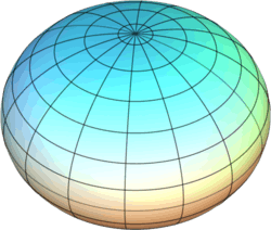
In geophysics, geodesy, and related areas, the word 'ellipsoid' is understood to mean 'oblate ellipsoid of revolution', and the older term 'oblate spheroid' is hardly used.[2][3] For bodies that cannot be well approximated by an ellipsoid of revolution a triaxial (or scalene) ellipsoid is used.
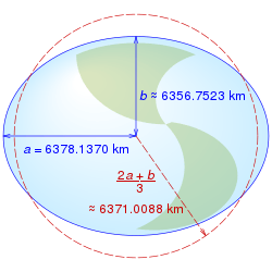
The shape of an ellipsoid of revolution is determined by the shape parameters of that ellipse. The semi-major axis of the ellipse, a, becomes the equatorial radius of the ellipsoid: the semi-minor axis of the ellipse, b, becomes the distance from the centre to either pole. These two lengths completely specify the shape of the ellipsoid.
In geodesy publications, however, it is common to specify the semi-major axis (equatorial radius) a and the flattening f, defined as

That is, f is the amount of flattening at each pole, relative to the radius at the equator. This is often expressed as a fraction 1/m; m = 1/f then being the "inverse flattening". A great many other ellipse parameters are used in geodesy but they can all be related to one or two of the set a, b and f.
A great many ellipsoids have been used to model the Earth in the past, with different assumed values of a and b as well as different assumed positions of the center and different axis orientations relative to the solid Earth. Starting in the late twentieth century, improved measurements of satellite orbits and star positions have provided extremely accurate determinations of the earth's center of mass and of its axis of revolution; and those parameters have been adopted also for all modern reference ellipsoids.
The ellipsoid WGS-84, widely used for mapping and satellite navigation has f close to 1/300 (more precisely, 1/298.257223563, by definition), corresponding to a difference of the major and minor semi-axes of approximately 21 km (13 miles) (more precisely, 21.3846858 km). For comparison, Earth's Moon is even less elliptical, with a flattening of less than 1/825, while Jupiter is visibly oblate at about 1/15 and one of Saturn's triaxial moons, Telesto, is highly flattened, with f between 1/3 to 1/2 (meaning that the polar diameter is between 50% and 67% of the equatorial.
Coordinates
A primary use of reference ellipsoids is to serve as a basis for a coordinate system of latitude (north/south), longitude (east/west), and ellipsoidal height.
For this purpose it is necessary to identify a zero meridian, which for Earth is usually the Prime Meridian. For other bodies a fixed surface feature is usually referenced, which for Mars is the meridian passing through the crater Airy-0. It is possible for many different coordinate systems to be defined upon the same reference ellipsoid.
The longitude measures the rotational angle between the zero meridian and the measured point. By convention for the Earth, Moon, and Sun it is expressed in degrees ranging from −180° to +180° For other bodies a range of 0° to 360° is used.
The latitude measures how close to the poles or equator a point is along a meridian, and is represented as an angle from −90° to +90°, where 0° is the equator. The common or geodetic latitude is the angle between the equatorial plane and a line that is normal to the reference ellipsoid. Depending on the flattening, it may be slightly different from the geocentric (geographic) latitude, which is the angle between the equatorial plane and a line from the center of the ellipsoid. For non-Earth bodies the terms planetographic and planetocentric are used instead.
The coordinates of a geodetic point are customarily stated as geodetic latitude ϕ and longitude λ (both specifying the direction in space of the geodetic normal containing the point), and the ellipsoidal height h of the point above or below the reference ellipsoid along its normal. If these coordinates are given, one can compute the geocentric rectangular coordinates of the point as follows:[4]

where

and a and b are the equatorial radius (semi-major axis) and the polar radius (semi-minor axis), respectively. N is the radius of curvature in the prime vertical.
In contrast, extracting φ, λ and h from the rectangular coordinates usually requires iteration. A straightforward method is given in an OSGB publication[5] and also in web notes.[6] More sophisticated methods are outlined in geodetic system.
Historical Earth ellipsoids
Currently the most common reference ellipsoid used, and that used in the context of the Global Positioning System, is the one defined by WGS 84.
Traditional reference ellipsoids or geodetic datums are defined regionally and therefore non-geocentric, e.g., ED50. Modern geodetic datums are established with the aid of GPS and will therefore be geocentric, e.g., WGS 84.
Other celestial bodies
Reference ellipsoids are also useful for geodetic mapping of other planetary bodies including planets, their satellites, asteroids and comet nuclei. Some well observed bodies such as the Moon and Mars now have quite precise reference ellipsoids.
For rigid-surface nearly-spherical bodies, which includes all the rocky planets and many moons, ellipsoids are defined in terms of the axis of rotation and the mean surface height excluding any atmosphere. Mars is actually egg shaped, where its north and south polar radii differ by approximately 6 km (4 miles), however this difference is small enough that the average polar radius is used to define its ellipsoid. The Earth's Moon is effectively spherical, having almost no bulge at its equator. Where possible, a fixed observable surface feature is used when defining a reference meridian.
For gaseous planets like Jupiter, an effective surface for an ellipsoid is chosen as the equal-pressure boundary of one bar. Since they have no permanent observable features, the choices of prime meridians are made according to mathematical rules.
Small moons, asteroids, and comet nuclei frequently have irregular shapes. For some of these, such as Jupiter's Io, a scalene (triaxial) ellipsoid is a better fit than the oblate spheroid. For highly irregular bodies, the concept of a reference ellipsoid may have no useful value, so sometimes a spherical reference is used instead and points identified by planetocentric latitude and longitude. Even that can be problematic for non-convex bodies, such as Eros, in that latitude and longitude don't always uniquely identify a single surface location.
See also
- Earth ellipsoid
- Earth radius of curvature
- Meridian arc
Notes
- Isaac Newton:Principia Book III Proposition XIX Problem III, p. 407 in Andrew Motte translation, available on line at
- Torge, W (2001) Geodesy (3rd edition), published by de Gruyter, ISBN 3-11-017072-8
- Snyder, John P. (1993). Flattening the Earth: Two Thousand Years of Map Projections. University of Chicago Press. p. 82. ISBN 0-226-76747-7.
- B. Hofmann-Wellenhof, H. Lichtenegger, J. Collins. GPS - theory and practice. Section 10.2.1. p. 282. ISBN 3-211-82839-7.CS1 maint: multiple names: authors list (link)
- A guide to coordinate systems in Great Britain. This is available as a pdf document at ["Archived copy". Archived from the original on 2012-02-11. Retrieved 2012-01-11.CS1 maint: archived copy as title (link)]] Appendices B1, B2
- Osborne, P (2008). The Mercator Projections Archived 2012-01-18 at the Wayback Machine Section 5.4
References
- P. K. Seidelmann (Chair), et al. (2005), “Report Of The IAU/IAG Working Group On Cartographic Coordinates And Rotational Elements: 2003,” Celestial Mechanics and Dynamical Astronomy, 91, pp. 203–215.
- Web address: https://astrogeology.usgs.gov/Projects/WGCCRE
- OpenGIS Implementation Specification for Geographic information - Simple feature access - Part 1: Common architecture, Annex B.4. 2005-11-30
- Web address: http://www.opengeospatial.org