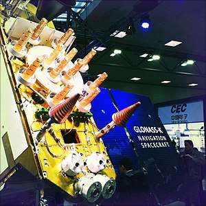
GLONASS
GLONASS (Russian: ГЛОНАСС, IPA: [ɡɫɐˈnas]; Глобальная навигационная спутниковая система, transliteration: Globalnaya navigatsionnaya sputnikovaya sistema), or "GLObal NAvigation Satellite System", is a space-based satellite navigation system operating as part of a radionavigation-satellite service. It provides an alternative to GPS and is the second navigational system in operation with global coverage and of comparable precision.
GLONASS logo | |
| Country/ies of origin | |
|---|---|
| Operator(s) | Roscosmos ( |
| Type | Military, civilian |
| Status | Operational |
| Coverage | Global |
| Accuracy | 2.8–7.38 metres |
| Constellation size | |
| Total satellites | 26 |
| Satellites in orbit | 24 |
| First launch | 12 October 1982 |
| Last launch | 16 March 2020 |
| Orbital characteristics | |
| Regime(s) | 3x MEO |
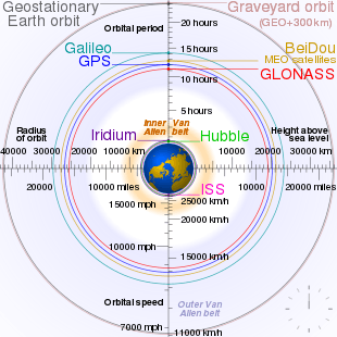
| Orbital height | 19,130 km |
| Geodesy | ||||||||||||||||||||||||||
|---|---|---|---|---|---|---|---|---|---|---|---|---|---|---|---|---|---|---|---|---|---|---|---|---|---|---|
 | ||||||||||||||||||||||||||
|
Fundamentals |
||||||||||||||||||||||||||
|
Concepts |
||||||||||||||||||||||||||
|
Technologies
|
||||||||||||||||||||||||||
|
Standards (history)
|
||||||||||||||||||||||||||
Manufacturers of GPS navigation devices say that adding GLONASS made more satellites available to them, meaning positions can be fixed more quickly and accurately, especially in built-up areas where buildings may obscure the view to some GPS satellites.[1][2][3] GLONASS supplementation of GPS systems also improves positioning in high latitudes (north or south).[4]
Development of GLONASS began in the Soviet Union in 1976. Beginning on 12 October 1982, numerous rocket launches added satellites to the system, until the completion of the constellation in 1995. After a decline in capacity during the late 1990s, in 2001, the restoration of the system was made a government priority and funding increased substantially. GLONASS is the most expensive program of the Russian Federal Space Agency, consuming a third of its budget in 2010.
By 2010 GLONASS had achieved full coverage of Russia's territory and in October 2011 the full orbital constellation of 24 satellites was restored, enabling full global coverage. The GLONASS satellites' designs have undergone several upgrades, with the latest version, GLONASS-K2, scheduled to enter service in 2019.[5] An announcement predicts the deployment of a group of communications and navigational satellites by 2040. The task also includes the delivery to the Moon of a series of spacecraft for orbital research and the establishment of a lunar communications and positioning system.[6]
System description
GLONASS is a global navigation satellite system, providing real time position and velocity determination for military and civilian users. The satellites are located in middle circular orbit at 19,100 kilometres (11,900 mi) altitude with a 64.8-degree inclination and a period of 11 hours and 15 minutes.[7][8] GLONASS's orbit makes it especially suited for usage in high latitudes (north or south), where getting a GPS signal can be problematic.[9][10] The constellation operates in three orbital planes, with eight evenly spaced satellites on each.[8] A fully operational constellation with global coverage consists of 24 satellites, while 18 satellites are necessary for covering the territory of Russia. To get a position fix the receiver must be in the range of at least four satellites.[7]
Signal
FDMA
GLONASS satellites transmit two types of signal: open standard-precision signal L1OF/L2OF, and obfuscated high-precision signal L1SF/L2SF.
The signals use similar DSSS encoding and binary phase-shift keying (BPSK) modulation as in GPS signals. All GLONASS satellites transmit the same code as their standard-precision signal; however each transmits on a different frequency using a 15-channel frequency division multiple access (FDMA) technique spanning either side from 1602.0 MHz, known as the L1 band. The center frequency is 1602 MHz + n × 0.5625 MHz, where n is a satellite's frequency channel number (n=−7,−6,−5,...0,...,6, previously n=0,...,13). Signals are transmitted in a 38° cone, using right-hand circular polarization, at an EIRP between 25 and 27 dBW (316 to 500 watts). Note that the 24-satellite constellation is accommodated with only 15 channels by using identical frequency channels to support antipodal (opposite side of planet in orbit) satellite pairs, as these satellites are never both in view of an earth-based user at the same time.
The L2 band signals use the same FDMA as the L1 band signals, but transmit straddling 1246 MHz with the center frequency 1246 MHz + n×0.4375 MHz, where n spans the same range as for L1.[11] In the original GLONASS design, only obfuscated high-precision signal was broadcast in the L2 band, but starting with GLONASS-M, an additional civil reference signal L2OF is broadcast with an identical standard-precision code to the L1OF signal.
The open standard-precision signal is generated with modulo-2 addition (XOR) of 511 kbit/s pseudo-random ranging code, 50 bit/s navigation message, and an auxiliary 100 Hz meander sequence (Manchester code), all generated using a single time/frequency oscillator. The pseudo-random code is generated with a 9-stage shift register operating with a period of 1 ms.
The navigational message is modulated at 50 bits per second. The superframe of the open signal is 7500 bits long and consists of 5 frames of 30 seconds, taking 150 seconds (2.5 minutes) to transmit the continuous message. Each frame is 1500 bits long and consists of 15 strings of 100 bits (2 seconds for each string), with 85 bits (1.7 seconds) for data and check-sum bits, and 15 bits (0.3 seconds) for time mark. Strings 1-4 provide immediate data for the transmitting satellite, and are repeated every frame; the data include ephemeris, clock and frequency offsets, and satellite status. Strings 5-15 provide non-immediate data (i.e. almanac) for each satellite in the constellation, with frames I-IV each describing five satellites, and frame V describing remaining four satellites.
The ephemerides are updated every 30 minutes using data from the Ground Control segment; they use Earth Centred Earth Fixed (ECEF) Cartesian coordinates in position and velocity, and include lunisolar acceleration parameters. The almanac uses modified Keplerian elements and is updated daily.
The more accurate high-precision signal is available for authorized users, such as the Russian military, yet unlike the US P(Y) code, which is modulated by an encrypting W code, the GLONASS restricted-use codes are broadcast in the clear using only security through obscurity. The details of the high-precision signal have not been disclosed. The modulation (and therefore the tracking strategy) of the data bits on the L2SF code has recently changed from unmodulated to 250 bit/s burst at random intervals. The L1SF code is modulated by the navigation data at 50 bit/s without a Manchester meander code.
The high-precision signal is broadcast in phase quadrature with the standard-precision signal, effectively sharing the same carrier wave, but with a ten-times-higher bandwidth than the open signal. The message format of the high-precision signal remains unpublished, although attempts at reverse-engineering indicate that the superframe is composed of 72 frames, each containing 5 strings of 100 bits and taking 10 seconds to transmit, with total length of 36 000 bits or 720 seconds (12 minutes) for the whole navigational message. The additional data are seemingly allocated to critical Luni-Solar acceleration parameters and clock correction terms.
Accuracy
At peak efficiency, the standard-precision signal offers horizontal positioning accuracy within 5–10 metres, vertical positioning within 15 metres (49 ft), a velocity vector measuring within 100 millimetres per second (3.9 in/s), and timing within 200 ns, all based on measurements from four first-generation satellites simultaneously;[12] newer satellites such as GLONASS-M improve on this.
GLONASS uses a coordinate datum named "PZ-90" (Earth Parameters 1990 – Parametry Zemli 1990), in which the precise location of the North Pole is given as an average of its position from 1990 to 1995. This is in contrast to the GPS's coordinate datum, WGS 84, which uses the location of the North Pole in 1984. As of 17 September 2007 the PZ-90 datum has been updated to version PZ-90.02 which differ from WGS 84 by less than 400 mm (16 in) in any given direction. Since 31 December 2013, version PZ-90.11 is being broadcast, which is aligned to the International Terrestrial Reference System at epoch 2011.0 at the centimetre level.[13][14]
CDMA
Since 2008, new CDMA signals are being researched for use with GLONASS.[15][16][17][18][19][20][21][22][23]
The interface control documents for GLONASS CDMA signals was published in August 2016.[24]
According to GLONASS developers, there will be three open and two restricted CDMA signals. The open signal L3OC is centered at 1202.025 MHz and uses BPSK(10) modulation for both data and pilot channels; the ranging code transmits at 10.23 million chips per second, modulated onto the carrier frequency using QPSK with in-phase data and quadrature pilot. The data is error-coded with 5-bit Barker code and the pilot with 10-bit Neuman-Hoffman code.[25][26]
Open L1OC and restricted L1SC signals are centered at 1600.995 MHz, and open L2OC and restricted L2SC signals are centered at 1248.06 MHz, overlapping with GLONASS FDMA signals. Open signals L1OC and L2OC use time-division multiplexing to transmit pilot and data signals, with BPSK(1) modulation for data and BOC(1,1) modulation for pilot; wide-band restricted signals L1SC and L2SC use BOC (5, 2.5) modulation for both data and pilot, transmitted in quadrature phase to the open signals; this places peak signal strength away from the center frequency of narrow-band open signals.[21][27]
Binary phase-shift keying (BPSK) is used by standard GPS and GLONASS signals. Binary offset carrier (BOC) is the modulation used by Galileo, modernized GPS, and BeiDou-2.
The navigational message of CDMA signals is transmitted as a sequence of text strings. The message has variable size - each pseudo-frame usually includes six strings and contains ephemerides for the current satellite (string types 10, 11, and 12 in a sequence) and part of the almanac for three satellites (three strings of type 20). To transmit the full almanac for all current 24 satellites, a superframe of 8 pseudo-frames is required. In the future, the superframe will be expanded to 10 pseudo-frames of data to cover full 30 satellites. The message can also contain Earth rotation parameters, ionosphere models, long-term orbit parameters for GLONASS satellites, and COSPAS-SARSAT messages. The system time marker is transmitted with each string; UTC leap second correction is achieved by shortening or lengthening (zero-padding) the final string of the day by one second, with abnormal strings being discarded by the receiver.[28] The strings have a version tag to facilitate forward compatibility: future upgrades to the message format will not break older equipment, which will continue to work by ignoring new data (as long as the constellation still transmits old string types), but up-to-date equipment will be able to use additional information from newer satellites.[29]
The navigational message of the L3OC signal is transmitted at 100 bit/s, with each string of symbols taking 3 seconds (300 bits). A pseudo-frame of 6 strings takes 18 seconds (1800 bits) to transmit. A superframe of 8 pseudo-frames is 14,400 bits long and takes 144 seconds (2 minutes 24 seconds) to transmit the full almanac.
The navigational message of the L1OC signal is transmitted at 100 bit/s. The string is 250 bits long and takes 2.5 seconds to transmit. A pseudo-frame is 1500 bits (15 seconds) long, and a superframe is 12,000 bits or 120 seconds (2 minutes).
L2OC signal does not transmit any navigational message, only the pseudo-range codes.
| Satellite series | Launch | Current status | Clock error | FDMA signals | CDMA signals | Interoperability CDMA signals | |||||
|---|---|---|---|---|---|---|---|---|---|---|---|
| 1602 + n×0.5625 MHz | 1246 + n×0.4375 MHz | 1600.995 MHz | 1248.06 MHz | 1202.025 MHz | 1575.42 MHz | 1207.14 MHz | 1176.45 MHz | ||||
| GLONASS | 1982–2005 | Out of service | 5×10⁻¹³ | L1OF, L1SF | L2SF | ||||||
| GLONASS-M | 2003– | In service | 1×10⁻¹³ | L1OF, L1SF | L2OF, L2SF | - | - | L3OC ‡ | |||
| GLONASS-K1 | 2011– | In service | 5×10⁻¹⁴...1×10−13 | L1OF, L1SF | L2OF, L2SF | - | - | L3OC | |||
| GLONASS-K2 | 2019– | Test satellite manufacturing | 5×10⁻¹⁵...5×10−14 | L1OF, L1SF | L2OF, L2SF | L1OC, L1SC | L2OC, L2SC | L3OC | |||
| GLONASS-V | 2023–2025 | Design phase | - | - | L1OC, L1SC | L2OC, L2SC | L3OC | ||||
| GLONASS-KМ | 2030– | Research phase | L1OF, L1SF | L2OF, L2SF | L1OC, L1SC | L2OC, L2SC | L3OC, L3SC | L1OCM | L3OCM | L5OCM | |
| "O": open signal (standard precision), "S": obfuscated signal (high precision); "F":FDMA, "С":CDMA; n=−7,−6,−5,...,6 ‡Glonass-M spacecraft produced since 2014 include L3OC signal | |||||||||||
Glonass-K1 test satellite launched in 2011 introduced L3OC signal. Glonass-M satellites produced since 2014 (s/n 755+) will also transmit L3OC signal for testing purposes.
Enhanced Glonass-K1 and Glonass-K2 satellites, to be launched from 2018, will feature a full suite of modernized CDMA signals in the existing L1 and L2 bands, which includes L1SC, L1OC, L2SC, and L2OC, as well as the L3OC signal. Glonass-K series should gradually replace existing satellites starting from 2018, when Glonass-M launches will cease.[23][30]
Glonass-KM satellites will be launched by 2025. Additional open signals are being studied for these satellites, based on frequencies and formats used by existing GPS, Galileo, and Beidou/COMPASS signals:
- open signal L1OCM using BOC(1,1) modulation centered at 1575.42 MHz, similar to modernized GPS signal L1C, Galileo signal E1, and Beidou/COMPASS signal B1C;
- open signal L5OCM using BPSK(10) modulation centered at 1176.45 MHz, similar to the GPS "Safety of Life" (L5), Galileo signal E5a, and Beidou/COMPASS signal B2a;[31]
- open signal L3OCM using BPSK(10) modulation centered at 1207.14 MHz, similar to Galileo signal E5b and Beidou/COMPASS signal B2b.[17]
Such an arrangement will allow easier and cheaper implementation of multi-standard GNSS receivers.
With the introduction of CDMA signals, the constellation will be expanded to 30 active satellites by 2025; this may require eventual deprecation of FDMA signals.[32] The new satellites will be deployed into three additional planes, bringing the total to six planes from the current three—aided by System for Differential Correction and Monitoring (SDCM), which is a GNSS augmentation system based on a network of ground-based control stations and communication satellites Luch 5A and Luch 5B.[33][34]
Six additional Glonass-V satellites, using Tundra orbit in three orbital planes, will be launched in 2023-2025; this regional high-orbit segment will offer increased regional availability and 25% improvement in precision over Eastern hemisphere, similar to Japanese QZSS system and Beidou-1.[35] The new satellites will form two ground traces with inclination of 64.8°, eccentricity of 0.072, period of 23.9 hours, and ascending node longitude of 60° and 120°. Glonass-V vehicles are based on Glonass-K platform and will broadcast new CDMA signals only.[35] Previously Molniya orbit, geosynchronous orbit, or inclined orbit were also under consideration for the regional segment.[17][28]
Navigational message
L1OC
| Field | Size, bits | Description | ||
|---|---|---|---|---|
| Timecode | СМВ | 12 | Constant bit sequence 0101 1111 0001 (5F1h) | |
| String type | Тип | 6 | Type of the navigational message | |
| Satellite ID | j | 6 | System ID number of the satellite (1 to 63; 0 is reserved until FDMA signal switch-off) | |
| Satellite state | Гj | 1 | This satellite is: 0 — healthy, 1 — in error state | |
| Data reliability | lj | 1 | Transmitted navigational messages are: 0 — valid, 1 — unreliable | |
| Ground control callback | П1 | 4 | (Reserved for system use) | |
| Orientation mode | П2 | 1 | Satellite orientiation mode is: 0 — Sun sensor control, 1 — executing predictive thrust or mode transition | |
| UTC correction | КР | 2 | On the last day of the current quarter, at 00:00 (24:00), a UTC leap second is: 0 — not expected, 1 — expected with positive value, 2 — unknown, 3 — expected with negative value | |
| Execute correction | А | 1 | After the end of the current string, UTC correction is: 0 — not expected, 1 — expected | |
| Satellite time | ОМВ | 16 | Onboard time of the day in 2 s intervals (0 to 43199) | |
| Information | 184 | Content of the information field is defined by string type | ||
| CRC | ЦК | 16 | Cyclic redundancy code | |
| Total | 250 | |||
L3OC
| Field | Size, bits | Description | |
|---|---|---|---|
| Timecode | СМВ | 20 | Constant bit sequence 0000 0100 1001 0100 1110 (0494Eh) |
| String type | Тип | 6 | Type of the navigational message |
| Satellite time | ОМВ | 15 | Onboard time of the day in 3 s intervals (0 to 28799) |
| Satellite ID | j | 6 | The same as in L1OC signal |
| Satellite state | Гj | 1 | |
| Data reliability | lj | 1 | |
| Ground control callback | П1 | 4 | |
| Orientation mode | П2 | 1 | |
| UTC correction | КР | 2 | |
| Execute correction | А | 1 | |
| Information | 219 | Content of the information field is defined by string type | |
| CRC | ЦК | 24 | Cyclic redundancy code |
| Total | 300 | ||
Common properties of open CDMA signals
| Type | Content of the information field |
|---|---|
| 0 | (Reserved for system use) |
| 1 | Short string for the negative leap second |
| 2 | Long string for the positive leap second |
| 10, 11, 12 | Real-time information (ephemerides and time-frequency offsets). Transmitted as a packet of three strings in sequence |
| 16 | Satellite orientation parameters for the predictive thrust maneuver |
| 20 | Almanac |
| 25 | Earth rotation parameters, ionosphere models, and time scale model for the difference between UTC(SU) and TAI |
| 31, 32 | Parameters of long-term movement model |
| 50 | Cospas-Sarsat service message — L1OC signal only |
| 60 | Text message |
| Field | Size, bits | Weight of the low bit | Description | ||
|---|---|---|---|---|---|
| Orbit type | ТО | 2 | 1 | 0 — circular orbit with 19100 km altitude [nb 2] | |
| Satellite number | NS | 6 | 1 | Total number of satellites transmitting CDMA signals (1 to 63) which are referenced to in the almanac | |
| Almanac age | EA | 6 | 1 | Number of full days passed since the last almanac update | |
| Current day | NA | 11 | 1 | Day number (1 to 1461) within a four-year interval starting on 1 January of the last leap year [nb 3] according to Moscow decree time | |
| Signal status | PCA | 5 | 1 | Bit field encoding types of CDMA signals transmitted by the satellite. Three highest bits correspond to signals L1, L2 и L3: 0 — transmitted, 1 — not transmitted | |
| Satellite type | PCA | 3 | 1 | Satellite model and the set of transmitted CDMA signals: 0 — Glonass-M (L3 signal), 1 — Glonass-K1 (L3 signal), 2 — Glonass-K1 (L2 and L3 signals), 3 — Glonass-K2 (L1, L2, and L3 signals) | |
| Time correction | τA | 14 | 2−20 | Rough correction from onboard time scale to the GLONASS time scale (±7.8×10⁻³ с) | |
| Ascension | λA | 21 | 2−20 | Longitude of the satellite's first orbital node (±1 half-cycles) | |
| Ascension time | tλA | 21 | 2−5 | Time of the day when the satellite is crossing its first orbital node (0 to 44100 s) | |
| Inclination | ΔiA | 15 | 2−20 | Adjustments to nominal inclination (64,8°) of the satellite orbit at the moment of ascension (±0.0156 half-cycles) | |
| Eccentricity | εA | 15 | 2−20 | Eccentricity of the satellite orbit at the ascension time (0 to 0.03) | |
| Perigee | ωA | 16 | 2−15 | Argument to satellite's perigee at the ascension time (±1 half-cycles) | |
| Period | ΔTA | 19 | 2−9 | Adjustments to the satellite's nominal draconic orbital period (40544 s) at the moment of ascension (±512 s) | |
| Period change | ΔṪA | 7 | 2−14 | Speed of change of the draconic orbital period at the moment of ascension (±3.9×10⁻³ s/orbit) | |
| (Reserved) | L1OC: 23 | - | |||
| L3OC: 58 | |||||
- Navigational message field j (satellite ID) references the satellite for the transmitted almanac (jA).
- The set of almanac parameters depends on the orbit type. Satellites with geosynchronous, medium-Earth, and high-elliptical orbits could be employed in the future.
- In a departure from the Gregorian calendar, all years exactly divisible by 100 (i.e. 2100 and so on) are treated as leap years.
Satellites
The main contractor of the GLONASS program is Joint Stock Company Reshetnev Information Satellite Systems (ISS Reshetnev, formerly called NPO-PM). The company, located in Zheleznogorsk, is the designer of all GLONASS satellites, in cooperation with the Institute for Space Device Engineering (ru:РНИИ КП) and the Russian Institute of Radio Navigation and Time. Serial production of the satellites is accomplished by the company PC Polyot in Omsk.
Over the three decades of development, the satellite designs have gone through numerous improvements, and can be divided into three generations: the original GLONASS (since 1982), GLONASS-M (since 2003) and GLONASS-K (since 2011). Each GLONASS satellite has a GRAU designation 11F654, and each of them also has the military "Cosmos-NNNN" designation.[36]
First generation
The true first generation of GLONASS (also called Uragan) satellites were all three-axis stabilized vehicles, generally weighing 1,250 kg (2,760 lb) and were equipped with a modest propulsion system to permit relocation within the constellation. Over time they were upgraded to Block IIa, IIb, and IIv vehicles, with each block containing evolutionary improvements.
Six Block IIa satellites were launched in 1985–1986 with improved time and frequency standards over the prototypes, and increased frequency stability. These spacecraft also demonstrated a 16-month average operational lifetime. Block IIb spacecraft, with a two-year design lifetimes, appeared in 1987, of which a total of 12 were launched, but half were lost in launch vehicle accidents. The six spacecraft that made it to orbit worked well, operating for an average of nearly 22 months.
Block IIv was the most prolific of the first generation. Used exclusively from 1988 to 2000, and continued to be included in launches through 2005, a total of 56 satellites were launched. The design life was three years, however numerous spacecraft exceeded this, with one late model lasting 68 months, nearly double.[37]
Block II satellites were typically launched three at a time from the Baikonur Cosmodrome using Proton-K Blok-DM-2 or Proton-K Briz-M boosters. The only exception was when, on two launches, an Etalon geodetic reflector satellite was substituted for a GLONASS satellite.
Second generation
The second generation of satellites, known as Glonass-M, were developed beginning in 1990 and first launched in 2003. These satellites possess a substantially increased lifetime of seven years and weigh slightly more at 1,480 kg (3,260 lb). They are approximately 2.4 m (7 ft 10 in) in diameter and 3.7 m (12 ft) high, with a solar array span of 7.2 m (24 ft) for an electrical power generation capability of 1600 watts at launch. The aft payload structure houses 12 primary antennas for L-band transmissions. Laser corner-cube reflectors are also carried to aid in precise orbit determination and geodetic research. On-board cesium clocks provide the local clock source. Glonass-M includes 31 satellites ranging from satellite index 21 - 92 and with 4 spare active satellites.
A total of 41 second generation satellites were launched through the end of 2013. As with the previous generation, the second generation spacecraft were launched three at a time using Proton-K Blok-DM-2 or Proton-K Briz-M boosters. Some were launched alone with Soyuz-2-1b/Fregat
On 30 July 2015, ISS Reshetnev announced that it had completed the last GLONASS-M (No. 61) spacecraft and it was putting it in storage waiting for launch, along with eight previously built satellites.[38][39]
As on 22 September 2017, GLONASS-M No. 52 satellite went into operation and the orbital grouping has again increased to 24 space vehicles.[40]
Third generation
GLONASS-K is a substantial improvement of the previous generation: it is the first unpressurised GLONASS satellite with a much reduced mass (750 kg (1,650 lb) versus 1,450 kg (3,200 lb) of GLONASS-M). It has an operational lifetime of 10 years, compared to the 7-year lifetime of the second generation GLONASS-M. It will transmit more navigation signals to improve the system's accuracy—including new CDMA signals in the L3 and L5 bands, which will use modulation similar to modernized GPS, Galileo, and Compass. Glonass-K consist of 26 satellites having satellite index 65-98 and widely used in Russian Military space.[41][42][43] The new satellite's advanced equipment—made solely from Russian components—will allow the doubling of GLONASS' accuracy.[7] As with the previous satellites, these are 3-axis stabilized, nadir pointing with dual solar arrays. The first GLONASS-K satellite was successfully launched on 26 February 2011.[41][44]
Due to their weight reduction, GLONASS-K spacecraft can be launched in pairs from the Plesetsk Cosmodrome launch site using the substantially lower cost Soyuz-2.1b boosters or in six-at-once from the Baikonur Cosmodrome using Proton-K Briz-M launch vehicles.[7][8]
Ground control
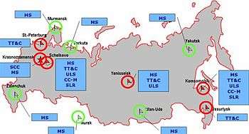
The ground control segment of GLONASS is almost entirely located within former Soviet Union territory, except for several in Brazil.[45]
The GLONASS ground segment consists of:[46]
- a system control centre;
- five Telemetry, Tracking and Command centers;
- two Laser Ranging Stations;[47] and
- ten Monitoring and Measuring Stations.[48]
| Location | System control | Telemetry, Tracking and Command | Central clock | Upload stations | Laser Ranging | Monitoring and Measuring |
|---|---|---|---|---|---|---|
| Krasnoznamensk | x | - | - | - | - | x |
| Schelkovo | - | x | x | x | x | x |
| Komsomolsk | - | x | - | x | x | x |
| Saint Petersburg | - | x | - | - | - | - |
| Ussuriysk | - | x | - | - | - | - |
| Yenisseisk | - | x | - | x | - | x |
| Yakutsk | - | - | - | - | - | x |
| Ulan-Ude | - | - | - | - | - | x |
| Nurek | - | - | - | - | - | x |
| Vorkuta | - | - | - | - | - | x |
| Murmansk | - | - | - | - | - | x |
| Zelenchuk | - | - | - | - | - | x |
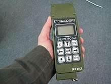
Receivers
Companies producing GNSS receivers making use of GLONASS:
- Furuno
- JAVAD GNSS, Inc
- Septentrio
- Topcon
- C-Nav
- Magellan Navigation
- Novatel
- Leica Geosystems
- Hemisphere GNSS
- Trimble Inc
- u-blox
NPO Progress describes a receiver called GALS-A1, which combines GPS and GLONASS reception.
SkyWave Mobile Communications manufactures an Inmarsat-based satellite communications terminal that uses both GLONASS and GPS.[49]
As of 2011, some of the latest receivers in the Garmin eTrex line also support GLONASS (along with GPS).[50] Garmin also produce a standalone Bluetooth receiver, the GLO for Aviation, which combines GPS, WAAS and GLONASS.[51]
Various smartphones from 2011 onwards have integrated GLONASS capability in addition to their pre-existing GPS receivers, with the intention of reducing signal acquisition periods by allowing the device to pick up more satellites than with a single-network receiver, including devices from:
Status
Availability
As of 31 May 2020,[59] the GLONASS constellation status is:[59]
| Total | 27 SC |
|---|---|
| Operational | 24 SC (Glonass-M/K) |
| In commissioning | 0 SC |
| In maintenance | 0 SC |
| Under check by the Satellite Prime Contractor | 0 SC |
| Spares | 2 SC |
| In flight tests phase | 1 SC (Glonass-K) |
| – |
The system requires 18 satellites for continuous navigation services covering the entire territory of the Russian Federation, and 24 satellites to provide services worldwide.[60] The GLONASS system covers 100% of worldwide territory.
On 2 April 2014 the system experienced a technical failure that resulted in practical unavailability of the navigation signal for around 12 hours.[61]
On 14–15 April 2014 nine GLONASS satellites experienced a technical failure due to software problems.[62]
On 19 February 2016 three GLONASS satellites experienced a technical failure: the batteries of GLONASS-738 exploded, the batteries of GLONASS-737 were depleted, and GLONASS-736 experienced a stationkeeping failure due to human error during maneuvering. GLONASS-737 and GLONASS-736 are expected to be operational again after maintenance, and one new satellite (GLONASS-751) to replace GLONASS-738 is expected to complete commissioning in early March. The full capacity of the satellite group is expected to be restored in the middle of March.[63] After the launching of two new satellites and maintenance of two others, the full capacity of the satellite group was restored.
Accuracy
The GLONASS accuracy is up to 2.8 metres, in comparison with GPS using the L5, which has accuracy of within 30 centimeters or 11.8 inches.[64][65]
According to Russian System of Differentional Correction and Monitoring's data, as of 2010, precision of GLONASS navigation definitions (for p=0.95) for latitude and longitude were 4.46–7.38 metres (14.6–24.2 ft) with mean number of navigation space vehicles (NSV) equals 7—8 (depending on station). In comparison, the same time precision of GPS navigation definitions were 2.00–8.76 metres (6 ft 7 in–28 ft 9 in) with mean number of NSV equals 6—11 (depending on station). Civilian GLONASS used alone is therefore very slightly less accurate than GPS. On high latitudes (north or south), GLONASS' accuracy is better than that of GPS due to the orbital position of the satellites.[66]
Some modern receivers are able to use both GLONASS and GPS satellites together, providing greatly improved coverage in urban canyons and giving a very fast time to fix due to over 50 satellites being available. In indoor, urban canyon or mountainous areas, accuracy can be greatly improved over using GPS alone. For using both navigation systems simultaneously, precision of GLONASS/GPS navigation definitions were 2.37–4.65 metres (7 ft 9 in–15 ft 3 in) with mean number of NSV equals 14—19 (depends on station).
In May 2009, Anatoly Perminov, then director of the Russian Federal Space Agency, stated that actions were undertaken to expand GLONASS's constellation and to improve the ground segment to increase the navigation definition of GLONASS to an accuracy of 2.8 metres (9 ft 2 in) by 2011.[67] In particular, the latest satellite design, GLONASS-K has the ability to double the system's accuracy once introduced. The system's ground segment is also to undergo improvements. As of early 2012, sixteen positioning ground stations are under construction in Russia and in the Antarctic at the Bellingshausen and Novolazarevskaya bases. New stations will be built around the southern hemisphere from Brazil to Indonesia. Together, these improvements are expected to bring GLONASS' accuracy to 0.6 m or better by 2020.[68] The setup of a GLONASS receiving station in the Philippines is also now under negotiation.[69]
History
Inception and design
The first satellite-based radio navigation system developed in the Soviet Union was Tsiklon, which had the purpose of providing ballistic missile submarines a method for accurate positioning. 31 Tsiklon satellites were launched between 1967 and 1978. The main problem with the system was that, although highly accurate for stationary or slow-moving ships, it required several hours of observation by the receiving station to fix a position, making it unusable for many navigation purposes and for the guidance of the new generation of ballistic missiles.[70] In 1968–1969, a new navigation system, which would support not only the navy, but also the air, land and space forces, was conceived. Formal requirements were completed in 1970; in 1976, the government made a decision to launch development of the "Unified Space Navigation System GLONASS".[71]
The task of designing GLONASS was given to a group of young specialists at NPO PM in the city of Krasnoyarsk-26 (today called Zheleznogorsk). Under the leadership of Vladimir Cheremisin, they developed different proposals, from which the institute's director Grigory Chernyavsky selected the final one. The work was completed in the late 1970s; the system consists of 24 satellites operating at an altitude of 20,000 kilometres (12,000 mi) in medium circular orbit. It would be able to promptly fix the receiving station's position based on signals from four satellites, and also reveal the object's speed and direction. The satellites would be launched three at a time on the heavy-lift Proton rocket. Due to the large number of satellites needed for the program, NPO PM delegated the manufacturing of the satellites to PO Polyot in Omsk, which had better production capabilities.[72][73]
Originally, GLONASS was designed to have an accuracy of 65 metres (213 ft), but in reality it had an accuracy of 20 metres (66 ft) in the civilian signal and 10 metres (33 ft) in the military signal.[9] The first generation GLONASS satellites were 7.8 metres (26 ft) tall, had a width of 7.2 metres (24 ft), measured across their solar panels, and a mass of 1,260 kilograms (2,780 lb).[9]
Achieving full orbital constellation
In the early 1980s, NPO PM received the first prototype satellites from PO Polyot for ground tests. Many of the produced parts were of low quality and NPO PM engineers had to perform substantial redesigning, leading to a delay.[72] On 12 October 1982, three satellites, designated Kosmos-1413, Kosmos-1414, and Kosmos-1415 were launched aboard a Proton rocket. As only one GLONASS satellite was ready in time for the launch instead of the expected three, it was decided to launch it along with two mock-ups. The USA media reported the event as a launch of one satellite and "two secret objects." For a long time, the USA could not find out the nature of those "objects". The Telegraph Agency of the Soviet Union (TASS) covered the launch, describing GLONASS as a system "created to determine the positioning of civil aviation aircraft, navy transport and fishing-boats of the Soviet Union".[72]
From 1982 to April 1991, the Soviet Union successfully launched a total of 43 GLONASS-related satellites plus five test satellites. When the Soviet Union disintegrated in 1991, twelve GLONASS satellites in two planes were operational; enough to allow limited use of the system (to cover the entire territory of the Union, 18 satellites would have been necessary.) The Russian Federation took over control of the constellation and continued its development.[73] GLONASS became operational in the year 1993 with 12 satellites in 2 orbits at the height of 19,130 km. The USA GPS system has achieved full operation а year later. In December 1995, the GLONASS constellation was increased to 24 satellites. At present, there are a total of 27 satellites in orbit, and all are operational.
Economic crisis
Since the first generation satellites operated for three years each, to keep the system at full capacity, two launches per year would have been necessary to maintain the full network of 24 satellites. However, in the financially difficult period of 1989–1999, the space program's funding was cut by 80% and Russia consequently found itself unable to afford this launch rate. After the full complement was achieved in December 1995, there were no further launches until December 1999. As a result, the constellation reached its lowest point of just six operational satellites in 2001. As a prelude to demilitarisation, responsibility of the program was transferred from the Ministry of Defence to Russia's civilian space agency Roscosmos.[9]
Renewed efforts and modernization
In the 2000s, the Russian economy recovered and state finances improved considerably. Vladimir Putin took a special interest in GLONASS[9] and the system's restoration was made one of the government's top priorities.[10] For this purpose, on August 2001, the Federal Targeted Program "Global Navigation System" 2002–2011 (Government Decision No. 587) was launched. The program was given a budget of $420 million[74] and aimed at restoring the full constellation by 2009.
On 10 December 2003, the second generation satellite design, GLONASS-M, was launched for the first time. It had a slightly larger mass than the baseline GLONASS, standing at 1,415 kg (3,120 lb), but it had seven years lifetime, four years longer than the lifetime of the original GLONASS satellite, decreasing the required replacement rate. The new satellite also had better accuracy and ability to broadcast two extra civilian signals.
In 2006, Defense Minister Sergey Ivanov ordered one of the signals (with an accuracy of 30 metres (98 ft)) to be made available to civilian users. Putin, however, was not satisfied with this, and demanded that the whole system should be made fully available to everyone. Consequently, on 18 May 2007, all restrictions were lifted.[75][76] The accurate, formerly military-only signal with a precision of 10 metres (33 ft), has since then been freely available to civilian users.
During the middle of the first decade of the 21st century, the Russian economy boomed, resulting in substantial increases in the country's space budget. In 2007, the financing of the GLONASS program was increased considerably; its budget was more than doubled. While in 2006 the GLONASS had received $181 million from the federal budget, in 2007 the amount was increased to $380 million.[75]
In the end, 140.1 billion rubles ($4.7 billion) were spent on the program 2001–2011, making it Roscosmos' largest project and consuming a third of its 2010 budget of 84.5 billion rubles.[77]
For the period of 2012 to 2020 320 billion rubles ($10 billion) were allocated to support the system.[78]
Restoring full capacity
In June 2008, the system consisted of 16 satellites, 12 of which were fully operational at the time. At this point, Roscosmos aimed at having a full constellation of 24 satellites in orbit by 2010, one year later than previously planned.[79]
In September 2008, Prime Minister Vladimir Putin signed a decree allocating additional 67 billion rubles ($2.6 billion) to GLONASS from the federal budget.[80]
Promoting commercial use
Although the GLONASS constellation has reached global coverage, its commercialisation, especially development of the user segment, has been lacking compared to the American GPS. For example, the first commercial Russian-made GLONASS navigation device for cars, Glospace SGK-70, was introduced in 2007, but it was much bigger and costlier than similar GPS receivers.[10] In late 2010, there were only a handful of GLONASS receivers on the market, and few of them were meant for ordinary consumers. To improve the situation, the Russian government has been actively promoting GLONASS for civilian use.[81]
To improve development of the user segment, on 11 August 2010, Sergei Ivanov announced a plan to introduce a 25% import duty on all GPS-capable devices, including mobile phones, unless they are compatible with GLONASS. The government also planned to force all car manufacturers in Russia to support GLONASS starting from 2011. This would affect all car makers, including foreign brands like Ford and Toyota, which have car assembly facilities in Russia.[82]
GPS and phone baseband chips from major vendors Qualcomm, Exynos and Broadcom[83] all support GLONASS in combination with GPS.
In April 2011, Sweden's Swepos—a national network of satellite reference stations that provides real-time positioning data with metre accuracy—became the first known foreign company to use GLONASS.[84]
Smartphones and Tablets also saw implementation of GLONASS support in 2011 with devices released that year from Xiaomi Tech Company (Xiaomi Phone 2), Sony Ericsson, Samsung (Galaxy Note, Galaxy Note II, Galaxy SII, Galaxy SIII mini, the Google Nexus 10 in late 2012), Asus, Apple (iPhone 4S and iPad Mini in late 2012), HTC and Sony Mobile adding support for the system allowing increased accuracy and lock on speed in difficult conditions.[85][86][87]
Finishing the constellation
Russia's aim of finishing the constellation in 2010 suffered a setback when a December 2010 launch of three GLONASS-M satellites failed. The Proton-M rocket itself performed flawlessly, but the upper stage Blok DM3 (a new version that was to make its maiden flight) was loaded with too much fuel due to a sensor failure. As a result, the upper stage and the three satellites crashed into the Pacific Ocean. Kommersant estimated that the launch failure cost up to $160 million.[88] Russian President Dmitry Medvedev ordered a full audit of the entire program and an investigation into the failure.[89]
Following the mishap, Roscosmos activated two reserve satellites and decided to make the first improved GLONASS-K satellite, to be launched in February 2011, part of the operational constellation instead of mainly for testing as was originally planned. This would bring the total number of satellites to 23, obtaining almost complete worldwide coverage.[90] The GLONASS-K2 was originally scheduled to be launched by 2013, however by 2012 was not expected to be launched until 2015.[91]
In 2010, President Dmitry Medvedev ordered the government to prepare a new federal targeted program for GLONASS, covering the years 2012–2020; the original 2001 program was scheduled to end in 2011.[88]
On 22 June 2011, Roscosmos revealed that the agency was looking for a funding of 402 billion rubles ($14.35 billion) for the program. The funds would be spent on maintaining the satellite constellation, on developing and maintaining navigational maps as well as on sponsoring supplemental technologies to make GLONASS more attractive to users.[92] On 2 October 2011 the 24th satellite of the system, a GLONASS-M, was successfully launched from Plesetsk Cosmodrome and is now in service.[93] This made the GLONASS constellation fully restored, for the first time since 1996.[94] On 5 November 2011 the Proton-M booster successfully put three GLONASS-M units in final orbit.[95] On Monday 28 November 2011, a Soyuz rocket, launched from the Plesetsk Cosmodrome Space Centre, placed a single GLONASS-M satellite into orbit into Plane 3.
On 26 April 2013 a single GLONASS-M satellite was delivered to the orbit by Soyuz rocket from Plesetsk Cosmodrome, restoring the constellation to 24 operational satellites, the minimum to provide global coverage.[96] On 2 July 2013 a Proton-M rocket, carrying 3 GLONASS-M satellites, crashed during takeoff from Baikonur Cosmodrome. It veered off the course just after leaving the pad and plunged into the ground nose first. The rocket employed a DM-03 booster, for the first time since the December 2010 launch, when the vehicle had also failed, resulting in a loss of another 3 satellites.[97]
However, as of 2014, while the system was completed from technical point of view, the operational side was still not closed by the Ministry of Defense and its formal status was still "in development".[61]
On 7 December 2015, the system was officially completed.[98]
See also
- List of GLONASS satellites
- Global navigation satellite system – the generic phrase for a global satellite positioning system
- Global Positioning System - United States counterpart
- Galileo - European Union counterpart
- BeiDou - Chinese counterpart
- NAVIC- Indian counterpart
- Multilateration – the mathematical technique used for positioning
- Tsikada – a Russian satellite navigation system
- Aviaconversiya – a Russian satellite navigation firm
- Era-glonass – GLONASS-based system of emergency response
Notes
- Orbital periods and speeds are calculated using the relations 4π2R3 = T2GM and V2R = GM, where R = radius of orbit in metres, T = orbital period in seconds, V = orbital speed in m/s, G = gravitational constant ≈ 6.673×10⁻¹¹ Nm2/kg2, M = mass of Earth ≈ 5.98×1024 kg.
- Approximately 8.6 times (in radius and length) when the moon is nearest (363 104 km ÷ 42 164 km) to 9.6 times when the moon is farthest (405 696 km ÷ 42 164 km).
References
- Angrisano, A; Petovello, M; Pugliano, G (2012). "Benefits of combined GPS/GLONASS with low-cost MEMS IMUs for vehicular urban navigation". Sensors. 12 (4): 5134–58. doi:10.3390/s120405134. PMC 3355462. PMID 22666079.
- "GLONASS significantly benefits GPS - OxTS". 15 September 2010.
- "Developer Tools - Sony Developer World". developer.sonymobile.com.
- "GPS, GLonaSS, and More" (PDF). University of New Brunswick.
Figure 2 shows the PDOP improvement in percentage when comparing the GPS-only to the GPS-plus-GLONASS PDOP values. At high latitudes, that is, above 55 degrees, the improvement is at the 30 percent level.
- Pietrobon, Steven (18 June 2018). "Russian launch manifest". Retrieved 2 August 2018.
- Sputnik. "Russia to Deploy Glonass-Type Satellites in Lunar Orbit by 2040". sputniknews.com. Retrieved 3 December 2018.
- Afanasyev, Igor; Dmitri Vorontsov (26 November 2010). "Glonass nearing completion". Russia & CIS Observer. Archived from the original on 30 November 2010.
- "The Global Navigation System GLONASS: Development and Usage in the 21st Century". 34th Annual Precise Time and Time Interval (PTTI) Meeting. 2002.
- Harvey, Brian (2007). "Military programs". The Rebirth of the Russian Space Program (1st ed.). Germany: Springer. ISBN 978-0-387-71354-0.
- Moskvitch, Katia (2 April 2010). "Glonass: Has Russia's sat-nav system come of age?". BBC News.
- GLONASS transmitter specs
- "A Review of GLONASS" Miller, 2000
- National Reference Systems of the Russian Federation used in GLONASS. V. Vdovin and M. Vinogradova (TSNIImash), 8th ICG meeting, Dubai, November 2013
- "The transition to using the terrestrial geocentric coordinate system "Parametry Zemli 1990" (PZ-90.11) in operating the GLObal NAvigation Satellite System (GLONASS) has been implemented". glonass-iac.ru. Retrieved 2 September 2015.
- "Russia Approves CDMA Signals for GLONASS, Discussing Common Signal Design". Inside GNSS. Archived from the original on 13 March 2018. Retrieved 30 December 2010.
- GLONASS Status and Progress Archived 14 June 2011 at the Wayback Machine, S.G.Revnivykh, 47th CGSIC Meeting, 2007. "L1CR and L5R CDMA interoperable with GPS and Galileo"
- GLONASS Status and Development, G.Stupak, 5th ICG Meeting
- Russia’s First GLONASS-K In Orbit, CDMA Signals Coming Archived 7 March 2011 at the Wayback Machine. Inside GNSS (2011-02-26). Retrieved on 2011-10-06.
- GLONASS Status and Modernization. Ekaterina Oleynik, Sergey Revnivykh, 51st CGSIG Meeting, September 2011
- GLONASS Status and Modernization. Sergey Revnivykh. 6th ICG Meeting, September 2011
- GLONASS Status and Modernization. Sergey Revnivykh. 7th ICG Meeting, November 2012
- GLONASS Government Policy, Status and Modernization Plans. Tatiana Mirgorodskaya. IGNSS-2013, 16 July 2013
- GLONASS Program Update. Ivan Revnivykh, Roscosmos. 11th ICG Meeting, November 2016
- Russian Space Systems JSC - GLONASS Interface Control Documents (in Russian)
- "GLONASS Modernization". GPS World. 2 November 2011. Archived from the original on 17 November 2015. Retrieved 2 September 2015.
- "Data" (PDF). www.insidegnss.com. 2011.
- GLONASS Modernization Yuri Urlichich, Valery Subbotin, Grigory Stupak, Vyacheslav Dvorkin, Alexander Povalyaev, Sergey Karutin, and Rudolf Bakitko, Russian Space Systems. GPS World, November 2011
- GLONASS: Developing Strategies for the Future. Yuri Urlichich, Valeriy Subbotin, Grigory Stupak, Vyacheslav Dvorkin, Alexander Povalyaev, and Sergey Karutin. GPS World, November 2011
- New Structure for GLONASS Nav Message Archived 12 December 2013 at the Wayback Machine Alexander Povalyaev. GPS World, 2 November 2013
- Testoyedov, Nikolay (18 May 2015). "Space Navigation in Russia: History of Development" (PDF). Retrieved 21 September 2016.
- "Russia to Put 8 CDMA Signals on 4 GLONASS Frequencies". Inside GNSS. 17 March 2010. Archived from the original on 5 December 2010. Retrieved 30 December 2010.
- "GLONASS Update Delves into Constellation Details". GPS World. Archived from the original on 1 January 2011. Retrieved 30 December 2010.
- "GLONASS Modernization: Maybe Six Planes, Probably More Satellites". GPS World. 10 January 2012. Archived from the original on 2 November 2018. Retrieved 24 December 2018.
- SDCM status and plans, Grigory Stupak, 7th ICG Meeting, November 2012
- "Directions 2019: High-orbit GLONASS and CDMA signal". 12 December 2018. Archived from the original on 22 December 2018. Retrieved 22 December 2018.
- Uragan, Russian Space Web
- GLONASS #787, 68.7 operational months; as reported by RSA "GLONASS constellation status" on 6 April 2007
- "Glonass-M – a chapter in the history of satellite navigation". JSC Information Satellite Systems. 30 July 2015. Retrieved 13 August 2015.
- "Russia stops manufacturing of Glonass-M navigation satellites". ITAR-TASS. 30 July 2015. Retrieved 20 August 2015.
- "Russia increases GLONASS orbital grouping to 24 satellites - Geospatial World". Geospatial World. 23 October 2017. Retrieved 23 October 2017.
- "Glonass-K: a prospective satellite of the GLONASS system" (PDF). Reshetnev Information Satellite Systems. 2007. Archived from the original (PDF) on 13 July 2011.
- "Russia to launch Glonass satellite on Feb. 24". RIA Novosti. 9 February 2011.
- Langley, Richard (2010). "GLONASS forecast bright and plentiful". GPS World. Archived from the original on 11 July 2012.
- "Russia launches satellite for global navigation system". BBC News. 26 February 2011.
- "Two More GLONASS stations are to open in the Brazilian states of Pernambuco and Rio Grande do Sull" [Two More GLONASS stations are to open in the Brazilian states of Pernambuco and Rio Grande do Sul]. RIA Novosti. Moscow: sputniknews.com. 14 July 2014. Retrieved 20 August 2016.
- "GLONASS Ground Segment - Navipedia". www.navipedia.net.
- "Russian Laser Tracking Network" (PDF).
- Current and planned global and regional navigation satellite systems and satellite-based augmentation systems
- "GLONASS added to SkyWave terminals", Digital Ship, 4 December 2009. Thedigitalship.com Archived 16 July 2011 at the Wayback Machine
- [Garmin eTrex 20 https://buy.garmin.com/shop/shop.do?cID=145&pID=87771#overviewTab]
- GLO for Aviation | Garmin. Buy.garmin.com. Retrieved on 2013-08-02.
- "Sony Xperia™ support (English)" (PDF). sonyericsson.com. Retrieved 2 September 2015.
- "Sony Ericsson и Huawei готовят смартфоны с ГЛОНАСС". CNews.ru. Archived from the original on 23 July 2015. Retrieved 2 September 2015.
- "Samsung GALAXY Note - Samsung Mobile". samsung.com. Retrieved 2 September 2015.
- Windows Phone 8X by HTC Overview - HTC Smartphones. Htc.com. Retrieved on 2013-08-02.
- Google Drive Viewer. Docs.google.com. Retrieved on 2013-08-02.
- "The Official Motorola Blog". motorola.com. Retrieved 2 September 2015.
- "GLONASS gets Nokia backing, aims to rival COMPASS". Reuters. 9 August 2011. Retrieved 2 September 2015.
- "Constellation status". glonass-iac.ru. Retrieved 16 February 2018.
- Russia to set world record with 39 space launches in 2009 RIA Novosti 2008-12-29
- "Роскосмос ищет причины сбоя ГЛОНАСС". Izvestia. 2014.
- "Система ГЛОНАСС вышла из строя второй раз за месяц". 2014.
- "Роскосмос обещает восстановить ГЛОНАСС к середине марта". 18 February 2016.
- "GPS will be accurate within one foot in some phones next year". The Verge. Archived from the original on 18 January 2018. Retrieved 17 January 2018.
- "Superaccurate GPS Chips Coming to Smartphones in 2018". IEEE Spectrum: Technology, Engineering, and Science News. 21 September 2017. Archived from the original on 18 January 2018. Retrieved 17 January 2018.
- "First Foreign Firm Embraces Glonass". The Moscow Times. 11 April 2011.
- "Роскосмос обещает повысить точность работы ГЛОНАСС с 10 до 5,5 метров". РИА Новости. Retrieved 2 September 2015.
- Kramnik, Ilya (16 February 2012). "GLONASS benefits worth the extra expense". Russia Beyond the Headlines.
- "DOST Finalizes MOU with Russian Space Agency". Department of Foreign Affairs (Philippines). 7 September 2018. Retrieved 24 September 2018.
- "Tsiklon". Encyclopedia Astronautica. Archived from the original on 28 June 2011.
- "Glonass". Encyclopedia Astronautica. Archived from the original on 29 November 2010.
- "Start of GLONASS" (PDF). ISS Reshetnev. 2007. Archived from the original (PDF) on 13 July 2011.
- "Satellite Navigation of the 21st Century" (PDF). ISS Reshetnev. 2009. Archived from the original (PDF) on 21 November 2010.
- Glonass still wants to be "the other guy in the sky Archived 13 February 2011 at the Wayback Machine. RT. 6 December 2010. Retrieved on 2011-10-06.
- "Putin makes Glonass navigation system free for customers – 1". RIA Novosti. 18 May 2007.
- "Russia to lift Glonass restrictions for accurate civilian use". RIA Novosti. 13 November 2006.
- GLONASS hits a snag. Russia Beyond The Headlines. 7 December 2010. Retrieved on 2011-10-06.
- "Работа в интересах развития ГЛОНАСС" [Work for the development of GLONASS] (PDF) (№30(318)). Сибирский спутник [Siberian Satellite]. 14 September 2012. p. 3. Archived from the original (PDF) on 21 October 2012. Retrieved 12 May 2013.
- "Russia's Glonass satellite system to be fully operational in 2010". RIA Novosti. 7 June 2008.
- "Putin orders additional $2.6 bln on Glonass development". RIA Novosti. 12 September 2008.
- "Glonass still wants to be "the other guy in the sky"". Russia Today. 7 December 2010. Archived from the original on 13 February 2011.
- Сотовые и навигаторы без ГЛОНАСС обложат пошлиной в 25% [Non-GLONASS-capable mobiles and satnavs will incur 25% duty] (in Russian). RBC Information Systems. 27 October 2010. Archived from the original on 28 October 2010. Retrieved 27 October 2010.
- Broadcom Upgrades Its A-GPS Data Service and GPS LTO Product/Service with GLONASS Satellite Support Archived 3 September 2012[Timestamp length] at Archive.today. Broadcom.com (2011-02-09). Retrieved on 2011-10-06.
- "Swedish firm starts using Russian satnav". Reuters. 11 April 2011. Archived from the original on 2 January 2012.
- GLONASS support in our latest Xperia™ phones – Developer World Archived 24 January 2012 at the Wayback Machine. Developer.sonyericsson.com. Retrieved on 2013-08-02.
- Samsung GALAXY Note - Samsung Mobile. Samsung.com. Retrieved on 2013-08-02.
- iPhone 5 - View all the technical specifications. Apple. Retrieved on 2013-08-02.
- "GLONASS hits a snag". Kommersant. 7 December 2010.
- Weir, Fred (6 December 2010). "Russia's $2 billion project to rival America's GPS suffers setback". Christian Science Monitor.
- Perminov, Anatoly (7 December 2010). "Interview of Anatoly Perminov to the Izvestia Newspaper" (in Russian). Roscosmos.
- "GLONASS network". 11 July 2013. Archived from the original on 3 March 2016. Retrieved 24 October 2013.
- "Glonass Asks for $14.35Bln". The Moscow Times. 22 June 2011.
- GLONASS finally becomes global NTV. 3 October 2011. (in Russian)
- Russia restores its orbital GLONASS group – official. The Voice of Russia. 3 October 2011. (in Russian)
- "TASS: Archive - 3 GLONASS satellites in final orbit". TASS. Retrieved 2 September 2015.
- "Third Soyuz launch in a week bolsters Glonass system". 26 April 2013. Retrieved 2 July 2013.
- "Russia's Proton crashes with a trio of navigation satellites". 2 July 2013. Archived from the original on 12 August 2015. Retrieved 2 July 2013.
- "Разработчики объявили о завершении создания ГЛОНАСС".
Standards
- "GLONASS Interface Control Document. Navigational radio signal in bands L1, L2 (Edition 5.1)" (PDF) (in Russian). Russian Space Systems OJSC. 2008. Retrieved 21 October 2016.
- "GLONASS Interface Control Document. Open CDMA navigational radio signal in L1 band. Edition 1.0" (PDF) (in Russian). Russian Space Systems OJSC. 2016. Retrieved 21 October 2016.
- "GLONASS Interface Control Document. Open CDMA navigational radio signal in L2 band. Edition 1.0" (PDF) (in Russian). Russian Space Systems OJSC. 2016. Retrieved 21 October 2016.
- "GLONASS Interface Control Document. Open CDMA navigational radio signal in L3 band. Edition 1.0" (PDF) (in Russian). Russian Space Systems OJSC. 2016. Retrieved 21 October 2016.
- "GLONASS Interface Control Document. General description of CDMA signals. Edition 1.0" (PDF) (in Russian). Russian Space Systems OJSC. 2016. Retrieved 21 October 2016.
Bibliography
- GLONASS Interface Control Document Edition 5.1, 2008 (backup)
- GLONASS Interface Control Document Version 4.0, 1998
- "ФЕДЕРАЛЬНАЯ ЦЕЛЕВАЯ ПРОГРАММА "ГЛОБАЛЬНАЯ НАВИГАЦИОННАЯ СИСТЕМА" FEDERAL SPECIAL-PURPOSE PROGRAM "GLOBAL NAVIGATION SYSTEM"". Russian Federal Government (in Russian). 20 August 2001. Archived from the original on 27 September 2007. Retrieved 10 April 2007.
- "GLONASS constellation status for 18.01.08 under the analysis of the almanac and accepted in IANC (UTC)". Russian Space Agency (RSA). Archived from the original on 24 October 2007. Retrieved 18 January 2008.
- "GLONASS Summary". Space and Tech. Archived from the original on 26 April 2007. Retrieved 12 April 2007.
- "GLONASS Transmitter Specifications". Archived from the original on 13 June 2007. Retrieved 13 April 2007.
- Goebel, Greg. "Navigation Satellites & GPS". pp. Section 2.2. Archived from the original on 22 October 2018. Retrieved 10 April 2007.
- "Интегральная доступность навигации наземного потребителя по системе ГЛОНАСС Integral accessibility of the navigation of ground-based user along the system GLONASS". Russian Space Agency (RSA) (in Russian). Archived from the original on 24 October 2007. Retrieved 18 January 2008.
- "India joins Russian GPS system". The Times of India. 29 January 2007. Retrieved 12 April 2007.
- "India to Launch 2 Russian GLONASS Satellites". MosNews. 27 June 2005. Archived from the original on 21 November 2005. Retrieved 12 April 2007.
- "Joint announcement (in English and Russian)". GPS/GLONASS Interoperability and Compatibility Working Group. 14 December 2006. Archived from the original on 19 September 2007. Retrieved 13 April 2007.
- Kramer, Andrew E. (7 April 2007). "Russia Challenges the U.S. Monopoly on Satellite Navigation". New York Times. Retrieved 12 April 2007.
- Miller, Keith M. (October 2000). "A Review of GLONASS". Hydrographic Society Journal. Archived from the original on 12 October 2007. Retrieved 13 April 2007. Cite journal requires
|journal=(help) - "Radical Change in the Air for GLONASS". GPS World. 22 January 2007. Archived from the original on 10 February 2007. Retrieved 10 April 2007.
- "Russia Allocates $380 Million for Global Navigation System in 2007". MosNews. 26 March 2007. Retrieved 12 April 2007.
- "Russia Holds First Place in Spacecraft Launches". MosNews. 26 March 2007. Retrieved 12 April 2007.
- "Russia Launches New Navigation Satellites into Orbit". Space.com / Associated Press. 25 December 2007. Archived from the original on 28 August 2008. Retrieved 28 December 2007.
- "Russian Space Agency Plans Cooperation With India". MosNews. 12 January 2004. Archived from the original on 7 February 2005. Retrieved 12 April 2007.
- "Space Policy Project's "World Space Guide: GLONASS"". Federation of American Scientists. Archived from the original on 3 April 2007. Retrieved 10 April 2007.
- "Услуги системы ГЛОНАСС будут предоставляться потребителям бесплатно The services of system GLONASS will be given to users free of charge" (in Russian). RIA Novosti. 18 May 2007. Retrieved 18 May 2007.
- "Три КА "Глонасс-М" взяты на управление Three KA "GLONASS-M" have taken off". Russian Space Agency (RSA) (in Russian). 26 December 2006. Archived from the original on 27 September 2007. Retrieved 29 December 2006.
- "Uragan (GLONASS, 11F654)". Gunter's Space Page. 16 January 2007. Retrieved 10 April 2007.
- "Uragan navsat (11F654)". Russian Space Web. Archived from the original on 3 March 2016. Retrieved 12 April 2007.
- "GLONASS News". Retrieved 31 July 2007.
External links
| Wikimedia Commons has media related to GLONASS. |
- Official GLONASS web page
- GNSS web page including GLONASS
- Description of GLONASS on the web page of the International Laser Ranging Service (ILRS)
- GLONASS: present, future and past Presented on the ILRS Technical Workshop, 14–19 September 2009, Metsovo, Greece
- A homemade receiver for GPS & GLONASS satellites
- Navipedia information on GLONASS—Wiki initiated by the European Space Agency
| Launch sites |
| ||||||||
|---|---|---|---|---|---|---|---|---|---|
| Launch vehicles | |||||||||
| Human spaceflight programs |
| ||||||||
| Robotic programs |
| ||||||||
| Communications | |||||||||
| Concepts | |||||||||
| Images and artwork | |||||||||
| Related | |||||||||