Myōkō, Niigata
Myōkō (妙高市, Myōkō-shi) is a city located in Niigata Prefecture, Japan. As of 1 July 2019, the city had an estimated population of 31,226 in 12,390 households, and a population density of 70.1 persons per km².[1] The total area are of the city was 445.63 square kilometres (172.06 sq mi). Myōkō is a member of the World Health Organization’s Alliance for Healthy Cities (AFHC).[2]
Myōkō 妙高市 | |
|---|---|
 Myōkō City Hall | |
 Flag  Seal | |
 Location of Myōkō in Niigata | |
 Myōkō | |
| Coordinates: 37°1′30.7″N 138°15′12.7″E | |
| Country | Japan |
| Region | Chūbu (Kōshin'etsu) (Hokuriku) |
| Prefecture | Niigata |
| Area | |
| • Total | 445.63 km2 (172.06 sq mi) |
| Population (July 1, 2019) | |
| • Total | 31,226 |
| • Density | 70/km2 (180/sq mi) |
| Time zone | UTC+9 (Japan Standard Time) |
| Symbols | |
| • Tree | Fagus crenata |
| • Flower | Glaucidium palmatum |
| • Bird | Blue-and-white flycatcher |
| Phone number | 0255-72-5111 |
| Address | 5-1 Sakaemachi, Myoko-shi, Niigata-ken 944-8686 |
| Website | Official website |
Geography
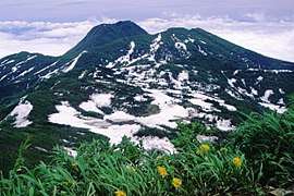
Myōkō is located in an inland region of north-central Niigata Prefecture, on the border of Nagano Prefecture. It lies in mountain surroundings near the historical entrance to the Echigo Plains. The city is surrounded by five mountains. Madarao, Myōkō, Kurohime, Togakushi and Iizuna are collectively known as the Five Peaks of Northern Shinano (Hokushingogaku). They make up the border of Nagano and Niigata Prefectures. Most of the city is covered with mountains and forests. As the city name implies, Mount Myōkō (2,454 metres (8,051 feet)) is in the city, much of which is within the borders of the Myōkō-Togakushi Renzan National Park.
Surrounding municipalities
Climate
Myōkō has a Humid climate (Köppen Cfa) characterized by warm, wet summers and cold winters with heavy snowfall. The average annual temperature in Myōkō is 13.3 °C. The average annual rainfall is 2357 mm with September as the wettest month. The temperatures are highest on average in August, at around 26.3 °C, and lowest in January, at around 1.8 °C.[3]
| Climate data for Sekiyama | |||||||||||||
|---|---|---|---|---|---|---|---|---|---|---|---|---|---|
| Month | Jan | Feb | Mar | Apr | May | Jun | Jul | Aug | Sep | Oct | Nov | Dec | Year |
| Average high °C (°F) | 3.3 (37.9) |
3.6 (38.5) |
7.4 (45.3) |
15.2 (59.4) |
20.5 (68.9) |
23.4 (74.1) |
27.0 (80.6) |
28.9 (84.0) |
24.4 (75.9) |
18.7 (65.7) |
12.8 (55.0) |
6.8 (44.2) |
16.0 (60.8) |
| Average low °C (°F) | −2.9 (26.8) |
−3.1 (26.4) |
−0.5 (31.1) |
5.1 (41.2) |
10.7 (51.3) |
15.6 (60.1) |
19.7 (67.5) |
21.1 (70.0) |
16.8 (62.2) |
10.5 (50.9) |
4.6 (40.3) |
−0.1 (31.8) |
8.1 (46.6) |
| Average precipitation mm (inches) | 325.1 (12.80) |
209.7 (8.26) |
135.8 (5.35) |
69.7 (2.74) |
88.7 (3.49) |
133.2 (5.24) |
188.1 (7.41) |
135.8 (5.35) |
168.7 (6.64) |
136.7 (5.38) |
150.9 (5.94) |
253.2 (9.97) |
1,995.6 (78.57) |
| Average snowfall cm (inches) | 422 (166) |
319 (126) |
175 (69) |
25 (9.8) |
0 (0) |
0 (0) |
0 (0) |
0 (0) |
0 (0) |
0 (0) |
15 (5.9) |
229 (90) |
1,185 (466.7) |
| Mean monthly sunshine hours | 74.5 | 87.9 | 118.6 | 167.1 | 175.8 | 126.1 | 123.0 | 156.5 | 107.8 | 117.6 | 105.7 | 84.2 | 1,444.8 |
| Source: 気象庁 Japan Meteorological Agency | |||||||||||||
Demographics
Per Japanese census data,[4] the population of Myōkō has declined steadily over the past 40 years.
| Census Year | Population |
|---|---|
| 1970 | 44,158 |
| 1980 | 41,980 |
| 1990 | 41,072 |
| 2000 | 39,699 |
| 2010 | 35,457 |
History
The area of present-day Myōkō was part of ancient Echigo Province. During the Edo period the area was divided between the holdings of Takada Domain and tenryō territory administered directly by the Tokugawa shogunate. With the creation of the modern municipalities system on June 26, 1890, the village of Arai was created within Nakakubiki District, Niigata. Arai was raised to town status on September 9, 1892 and to city status on November 1, 1954. The city of Myōkō was created on April 1, 2005, by the merger of the city of Arai with the town of Myōkōkōgen, and the village of Myōkō (both from Nakakubiki District).
Economy
The economy of Myōkō is dependent on seasonal tourism, agriculture and forestry, and light manufacturing.
Government
Myōkō has a mayor-council form of government with a directly elected mayor and a unicameral city legislature of 18 members.
Education
Myōkō has ten public elementary schools and four public middle schools. There is one public high school, and also one special education school.
Transportation
Railway
![]()
- Myōkō-Kōgen - Sekiyama - <Nihongi> - Arai - Kita-Arai
Highway
A Note: Jōetsumyōkō station is actually in Jōetsu, 1.5 km away from the border with Myōkō.
Local attractions
- Myōkōkōgen and the former village of Myōkō are famed for their ski resorts. The first of these, Akakura, was founded in the 1930s, making it one of the oldest established ski areas in the world. It is also a traditional mountain retreat of Japan's imperial family. The Myōkō Ski Area has nine main mountain resorts: Myōkō Akakura, Ikenotaira Onsen, Myōkō Suginohara (which boasts the longest ski run in Japan), Seki Onsen, Kyukamura, Myōkō Ski Park, Lotte Arai Resort, Madarao Kogen and Tangram Ski Circus.[5]
- Myōkō Kōgen is also well known for its many local onsen (hot springs) emanating from the Jigoku-dani valley between Mts. Myōkō and Mae.[6]
- Kannondaira-Tenjindō Kofun Cluster is a Kofun period National Historic Site
- Samegao Castle Site, ruins of a Sengoku period castle and National Historic Site
- Hida Sites, Jōmon period archaeological site and National Historic Site
International relations
References
External links
| Wikimedia Commons has media related to Myoko, Niigata. |
- Official Website (in Japanese)
- Travel Website (in English)
| Wards of Niigata | ||
|---|---|---|
| Special cities | ||
| Cities | ||
| Districts | ||