Sedalia, North Carolina
Sedalia is a town in Guilford County, North Carolina, United States. The population was 623 at the 2010 census.[4]
Sedalia, North Carolina | |
|---|---|
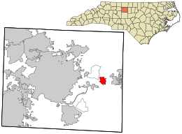 Location in Guilford County and the state of North Carolina | |
| Coordinates: 36°4′42″N 79°37′39″W | |
| Country | United States |
| State | North Carolina |
| County | Guilford |
| Area | |
| • Total | 2.09 sq mi (5.42 km2) |
| • Land | 2.09 sq mi (5.41 km2) |
| • Water | 0.008 sq mi (0.02 km2) |
| Elevation | 702 ft (214 m) |
| Population (2010) | |
| • Total | 623 |
| • Estimate (2018)[1] | 678 |
| • Density | 300/sq mi (110/km2) |
| Time zone | UTC-5 (Eastern (EST)) |
| • Summer (DST) | UTC-4 (EDT) |
| ZIP code | 27342 |
| Area code(s) | 336 |
| FIPS code | 37-60180[2] |
| GNIS feature ID | 0994476[3] |
| Website | sedalianc |
History
The Dr. Joseph A. McLean House and Palmer Memorial Institute Historic District are listed on the National Register of Historic Places.[5]
Geography
Sedalia is located in eastern Guilford County at 36°4′42″N 79°37′39″W (36.078407, -79.627444).[6] U.S. Route 70 (Burlington Road) passes through the center of the town, leading east 11 miles (18 km) to Burlington and west 11 miles (18 km) to Greensboro. Interstate 40 passes just south of Sedalia, with access from Exit 135 (Rock Creek Dairy Road).
According to the United States Census Bureau, the town has a total area of 2.1 square miles (5.4 km2), of which 0.01 square miles (0.02 km2), or 0.30%, is water.[4]
Demographics
| Historical population | |||
|---|---|---|---|
| Census | Pop. | %± | |
| 2000 | 618 | — | |
| 2010 | 623 | 0.8% | |
| Est. 2018 | 678 | [1] | 8.8% |
| U.S. Decennial Census[7] | |||
As of the census[2] of 2000, there were 618 people, 226 households, and 181 families residing in the town. The population density was 266.8 people per square mile (102.8/km²). There were 240 housing units at an average density of 103.6 per square mile (39.9/km²). The racial makeup of the town was 13.92% White, 83.82% African American, 0.16% Asian, 0.32% from other races, and 1.78% from two or more races. Hispanic or Latino of any race were 0.32% of the population.
There were 226 households out of which 27.0% had children under the age of 18 living with them, 51.3% were married couples living together, 22.6% had a female householder with no husband present, and 19.9% were non-families. 18.6% of all households were made up of individuals and 5.8% had someone living alone who was 65 years of age or older. The average household size was 2.71 and the average family size was 3.03.
In the town, the population was spread out with 20.6% under the age of 18, 9.7% from 18 to 24, 24.1% from 25 to 44, 32.0% from 45 to 64, and 13.6% who were 65 years of age or older. The median age was 42 years. For every 100 females, there were 100.6 males. For every 100 females age 18 and over, there were 94.8 males.
The median income for a household in the town was $43,021, and the median income for a family was $45,469. Males had a median income of $28,571 versus $26,591 for females. The per capita income for the town was $17,348. About 9.8% of families and 10.8% of the population were below the poverty line, including 18.1% of those under age 18 and 2.7% of those age 65 or over.
Places of interest
Sedalia is home to the Charlotte Hawkins Brown Museum on the site of the former Palmer Memorial Institute (1902–1971), a preparatory school for African-American students.
References
- "Population and Housing Unit Estimates". Retrieved March 12, 2020.
- "U.S. Census website". United States Census Bureau. Retrieved 2008-01-31.
- "US Board on Geographic Names". United States Geological Survey. 2007-10-25. Retrieved 2008-01-31.
- "Geographic Identifiers: 2010 Demographic Profile Data (G001): Sedalia town, North Carolina". American Factfinder. U.S. Census Bureau. Retrieved January 11, 2017.
- "National Register Information System". National Register of Historic Places. National Park Service. July 9, 2010.
- "US Gazetteer files: 2010, 2000, and 1990". United States Census Bureau. 2011-02-12. Retrieved 2011-04-23.
- "Census of Population and Housing". Census.gov. Retrieved June 4, 2015.
Municipalities and communities of Guilford County, North Carolina, United States | ||
|---|---|---|
| Cities | 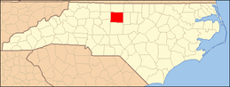 | |
| Towns | ||
| CDPs | ||
| Unincorporated communities | ||
| Footnotes | ‡This populated place also has portions in an adjacent county or counties | |
| Authority control |
|
|---|