Pacific Remote Islands Marine National Monument
The Pacific Remote Islands Marine National Monument is a group of unorganized, mostly unincorporated United States Pacific Island territories managed by the Fish and Wildlife Service of the United States Department of the Interior and the National Oceanic and Atmospheric Administration of the United States Department of Commerce.[2][3] These remote refuges are "the most widespread collection of marine- and terrestrial-life protected areas on the planet under a single country's jurisdiction".[2][3] They protect many endemic species including corals, fish, shellfish, marine mammals, seabirds, water birds, land birds, insects, and vegetation not found elsewhere.[4]
| Pacific Remote Islands Marine National Monument | |
|---|---|
IUCN category V (protected landscape/seascape) | |
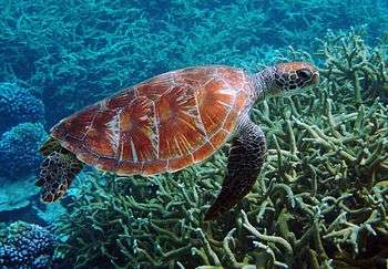 Green sea turtle at Palmyra Atoll National Wildlife Refuge | |
| Location | Central Pacific Ocean |
| Area | 313,818,892 acres (1,269,980.00 km2)[1] |
| Created | January 6, 2009 |
| Administrator | Kate Toniolo, Superintendent, U.S. Fish and Wildlife Service |
| Website | Pacific Remote Islands Marine National Monument |


History
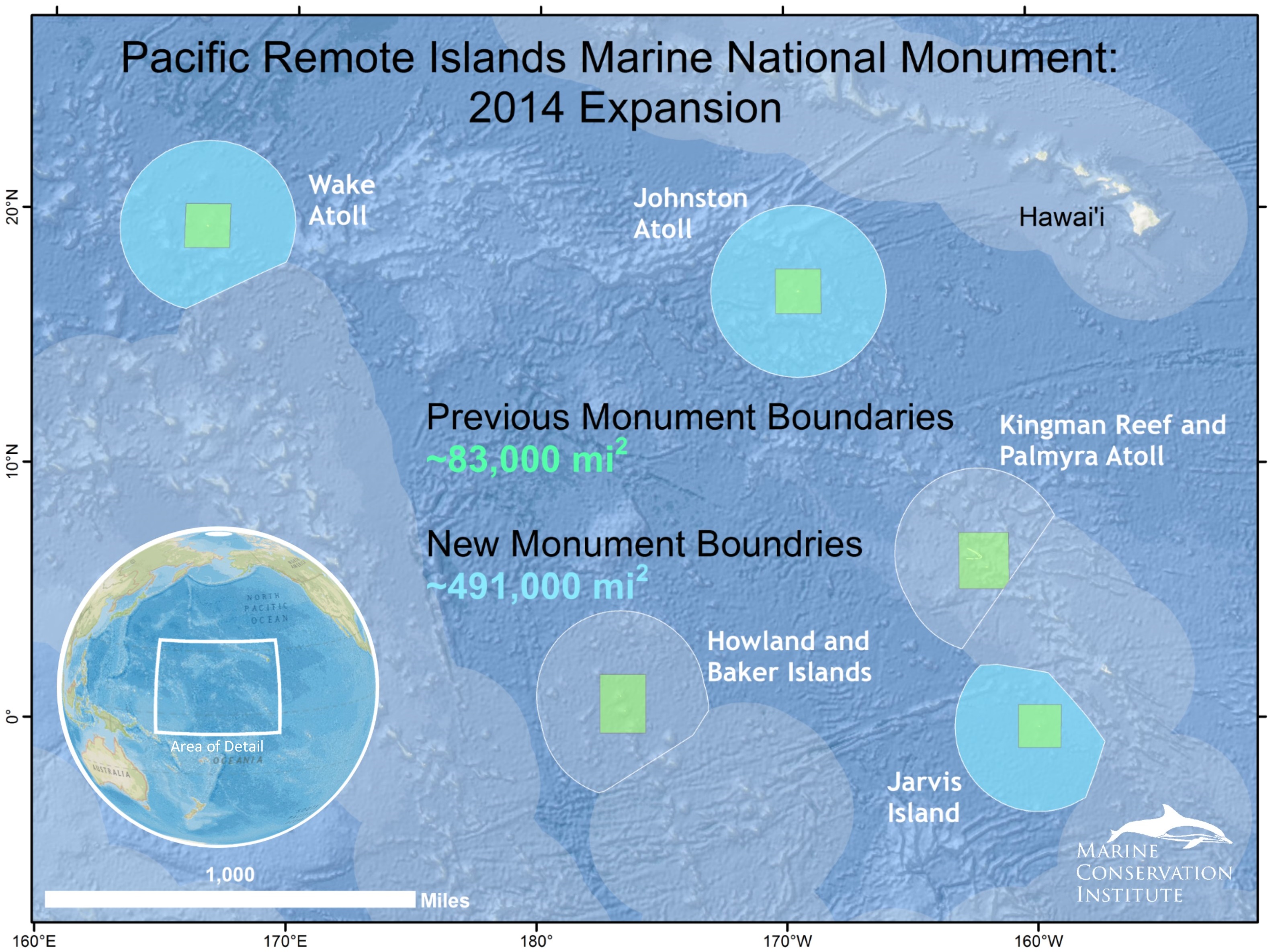
The Pacific Remote Islands Marine National Monument was proclaimed a national monument on January 6, 2009, by U.S. President George W. Bush[2][3] and follows his June 6, 2006, creation of the Papahānaumokuākea Marine National Monument in the Northwestern Hawaiian Islands. It was expanded on September 25, 2014 by U.S. President Barack Obama. The monument covers 490,343 square miles (1,269,980 km2),[1] spanning areas to the far south and west of Hawaii: Kingman Reef, Palmyra Atoll, Howland Island, Baker Island, Jarvis Island, Johnston Atoll, and Wake Island. At Howland Island, Baker Island, Jarvis Island, Palmyra Atoll, and Kingman Reef the terrestrial areas, reefs, and waters out to 12 nautical miles (22 km; 14 mi) (radius) are part of the National Wildlife Refuge System. For Kingman Reef and Palmyra Atoll and Howland Island and Baker Island, fishery-related activities seaward from the 12 nmi (22 km) refuge boundaries out to the 50 nmi (93 km) NMM boundary (about 100 nmi (190 km) square across) are managed by the National Oceanic and Atmospheric Administration. For Jarvis Island, Johnston Atoll, and Wake Island fishery-related activities seaward from the 12 nmi (22 km) refuge boundaries out to the 200 nmi (370 km) NMM boundary (U.S. EEZ waters) are managed by the National Oceanic and Atmospheric Administration. The land areas at Wake and Johnston Atolls remain under the jurisdiction of the U.S. Air Force, but the waters from 0 to 12 nmi (22 km) are protected as units of the National Wildlife Refuge System. The entire monument is closed to commercial fishing and other resource extraction activities, such as deep sea mining.[5]
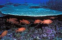
The monument includes endemic trees, grasses, and birds adapted to life at the Equator; the rare sea turtles and whales and Hawaiian monk seals that visit Johnston Atoll; and high-quality coral reefs. U.S. federal law prohibits resource destruction or extraction, waste dumping, and commercial fishing in the monument areas. Research, free passage, and recreation are allowed.
On June 17, 2014, U.S. President Barack Obama proposed using his executive powers to expand the marine protected area to 782,000 square miles (2,030,000 km2). Sport fishing is exempt and public comments were solicited.[6] He then signed a proclamation on September 25, 2014, expanding the Monument to six times its original size, resulting in 490,343 square miles (1,269,982 square kilometers)[1] of protected area around these tropical islands and atolls in the south-central Pacific Ocean. Expanding the Monument protected the deep coral reefs, seamounts, and marine ecosystems unique to this part of the world, which are also among the most vulnerable areas to the impacts of climate change and ocean acidification.[5]
In September 2017, Trump Administration U.S. Interior Secretary Ryan Zinke recommended that the boundaries of the monument be reduced by an unspecified amount.[7]
Geography
Location and area
The following islands form the basis of the Pacific Remote Islands Marine National Monument:
- Baker Island, an atoll in the North Pacific Ocean 1,830 nautical miles (3,390 kilometres) southwest of Honolulu, coordinates 0°13′N 176°31′W, about halfway between Hawaii and Australia. The atoll has a total area of 129 km², of which 2.1 km² is land and 127 km² is water.
- Howland Island, an island in the North Pacific Ocean 1,815 nmi (3,361 km) southwest of Honolulu, coordinates 0°48′N 176°38′W, about halfway between Hawaii and Australia. The island has a total area of 139 km², of which 2.6 km² is land and 136 km² is water.
- Jarvis Island, an island in the South Pacific Ocean 1,305 nmi (2,417 km) south of Honolulu, coordinates 0°23′S 160°01′W, about halfway between Hawaii and the Cook Islands. The island has a total area of 152 km², of which 5 km² is land and 147 km² is water.
- Johnston Atoll, an atoll in the North Pacific Ocean 717 nmi (1,328 km) southwest of Honolulu, coordinates 16°45′N 169°31′W, about one-third of the way from Hawaii to the Marshall Islands. The atoll has a total area of 276.6 km², of which 2.6 km² is land and 274 km² is water.
- Kingman Reef, a reef in the North Pacific Ocean 930 nmi (1,720 km) south of Honolulu, coordinates 6°23′N 162°25′W, about halfway between Hawaii and American Samoa. The reef has a total area of 1,958.01 km², of which 0.01 km² is land and 1,958 km² is water.
- Palmyra Atoll, an atoll in the North Pacific Ocean 960 nmi (1,780 km) south of Honolulu, coordinates 5°53′N 162°05′W, about halfway between Hawaii and American Samoa. The atoll has a total area of 1,949 km², of which 3.9 km² is land and 1,946 km² is water.
- Wake Island
Climate

Because the islands are scattered throughout the ocean, the climate is different on each island. Baker, Howland, and Jarvis Islands have an equatorial climate, with scant rainfall, constant wind, and burning sun. Johnston Atoll and Kingman Reef have a tropical climate, but are generally dry, with consistent northeast trade winds with little seasonal temperature variation. Palmyra Atoll has a hot, equatorial climate. Because the atoll is located within the low pressure area of the Intertropical Convergence Zone where the northeast and southeast trade winds meet, it is extremely wet with between 4,000–5,000 mm (160–200 in) of rainfall each year.[4]
Population
Although the islands have no permanent residents, the seven islands that make up the Pacific Remote Islands are stepping stones that connect Hawaii to Micronesia, and other Polynesian sea voyaging cultures. The voyage from Hawaii to neighboring Marshall Islands once included a stop at Johnston Atoll. Wake Atoll is geographically, culturally, and historically linked to the people who live in the Republic of the Marshall Islands. Kingman, Palmyra, Jarvis, Howland, and Baker are connected to the Republic of Kiribati. Voyaging and culture link all of these islands.[8]
Wake has a current transient population of ca. 125 military personnel and contractors. Johnston Atoll had a peak population of 1,100 military and civilian contractor personnel in 2000, but it was evacuated by 2007. Since 2010, volunteer biologists live and work on the island in groups of 5. Four to twenty Nature Conservancy and U.S. Fish and Wildlife staff live at Palmyra Atoll at any one time. The four other islands are usually uninhabited.
Public entry to the islands is by special-use permit from U.S. Fish and Wildlife Service, and is generally restricted to scientists and educators.[4] Only Wake Island, Palmyra Atoll and Johnston Atoll have serviceable runways; Jarvis, Baker and Howland Islands had airstrips in earlier times but they have long been abandoned and are no longer operational.
See also
- Bibliography of Wake Island
- Howland and Baker islands, includes coverage of the Howland-Baker Islands EEZ
- Marianas Trench Marine National Monument
- Rose Atoll Marine National Monument
Notes
- "MPAtlas". Archived from the original on 6 October 2014. Retrieved 16 October 2014.
- "Presidential Proclamation 8336" (PDF). fws.gov. Archived (PDF) from the original on 1 October 2017. Retrieved 23 April 2018.
- Weekly Compilation of Presidential Documents: Monday, January 12, 2009 Volume 45—Number 1, Page 14 Archived March 1, 2009, at the Wayback Machine
-

- Whitehouse.gov (25 Sept 2014) "FACT SHEET: President Obama to Designate Largest Marine Monument in the World Off-Limits to Development". Retrieved 25 Sept 2014. "Archived copy". Archived from the original on 2014-09-29. Retrieved 2014-09-29.CS1 maint: archived copy as title (link)
- Eilperin, Juliet. (17 June 2014) "Obama proposes vast expansion of Pacific Ocean sanctuaries for marine life". Washington Post. Retrieved 17 June 2014. "Archived copy". Archived from the original on 2017-10-13. Retrieved 2017-09-07.CS1 maint: archived copy as title (link)
- Eilperin, Juliet (2017-09-17). "Shrink at least 4 national monuments and modify a half-dozen others, Zinke tells Trump". Washington Post. ISSN 0190-8286. Archived from the original on 2017-09-18. Retrieved 2017-09-18.
- "Connecting Conservation and Culture in Oceania". www.taotaotasi.com. Archived from the original on 22 February 2018. Retrieved 23 April 2018.
External links
| Wikimedia Commons has media related to United States Pacific Island Wildlife Refuges. |
- Official website
- Pacific Remote Islands Marine National Monument|, photo gallery by USFWS
- Copy of official map