Wupatki National Monument
The Wupatki National Monument is a United States National Monument located in north-central Arizona, near Flagstaff. Rich in Native American archaeological sites, the monument is administered by the National Park Service in close conjunction with the nearby Sunset Crater Volcano National Monument. Wupatki was listed on the National Register of Historic Places on October 15, 1966. The listing included three contributing buildings and 29 contributing structures on 35,253.2 acres (14,266.5 ha).[4][5]
| Wupatki National Monument | |
|---|---|
IUCN category V (protected landscape/seascape) | |
 Wukoki ruins in 2008 | |
 | |
| Location | Coconino County, Arizona, USA |
| Nearest city | Flagstaff, Arizona |
| Coordinates | 35°33′56″N 111°23′13″W |
| Area | 35,422 acres (143.35 km2)[1] |
| Created | December 9, 1924[2] |
| Visitors | 205,122 (in 2018)[3] |
| Governing body | National Park Service |
| Website | Wupatki National Monument |
History
The many settlement sites scattered throughout the monument were built by the Ancient Pueblo People, more specifically the Cohonina, Kayenta Anasazi, and Sinagua. Wupatki was first inhabited around 500 AD. Wupatki, which means "Tall House" in the Hopi language, is a multistory Sinagua pueblo dwelling comprising over 100 rooms and a community room and the northernmost ballcourt ever discovered in North America, creating the largest building site for nearly 50 miles. Nearby secondary structures have also been uncovered, including two kiva-like structures.[6] A major population influx began soon after the eruption of Sunset Crater in the 11th century (between 1040 and 1100), which blanketed the area with volcanic ash, improving agricultural productivity and the soil's ability to retain water. By 1182, approximately 85 to 100 people lived at Wupatki Pueblo, but by 1225, the site was permanently abandoned. Based on a careful survey of archaeological sites conducted in the 1980s, an estimated 2,000 people moved into the area during the century following the eruption. Agriculture was based mainly on maize and squash raised on the arid land without irrigation. In the Wupatki site, the residents harvested rainwater due to the rarity of springs.

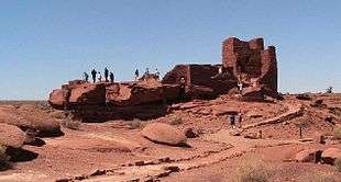
The dwelling's walls were constructed from thin, flat blocks of the local Moenkopi sandstone, giving the pueblos their distinct red color. Held together with mortar, many of the walls still stand. Each settlement was constructed as a single building, sometimes with scores of rooms. The largest settlement on monument territory is the Wupatki Ruin, built around a natural rock outcrop. With more than 100 rooms, this ruin is believed to be the region's tallest and largest structure for its time period. The monument also contains ruins identified as a ball court, similar to those found in Mesoamerica and in the Hohokam ruins of southern Arizona; this is the northernmost example of this kind of structure. This site also contains a geological blowhole[7], from which wind escapes from a cave system. Other major sites are Wukoki and The Citadel.
Today, Wupatki appears empty and abandoned, but it is remembered and cared for. Although it is no longer physically occupied, Hopi believe the people who lived and died here remain as spiritual guardians. Stories of Wupatki are passed on among Hopi, Navajo, Zuni, and other Native American tribes in the region. Members of the Hopi Bear, Katsina, Lizard, Rattlesnake, Sand, Snow, and Water Clans return periodically to enrich their personal understanding of their clan history.[8]
Amidst what would seem a generally inhospitable area due to the lack of food and water sources, several artifacts have been located at the site from distant locations, implying that the people who inhabited Wupatki were involved in trade. During numerous excavations stretching back to the site' exploration in the mid-1800s,[9] items from as far as the Pacific and the Gulf Coasts have been located at the site, such as many different varieties of pottery and seashells.
- Wupatki Ruins
 Wupatki Ruin Paronama
 Wupatki Ruin Ball Court
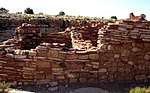 Box Canyon Ruins
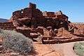 Wupatki Pueblo
References
- "Listing of acreage as of December 31, 2011". Land Resource Division, National Park Service. Retrieved 2012-05-14.
- . 9 December 1924 – via Wikisource.
- "NPS Annual Recreation Visits Report". National Park Service. Retrieved 2019-04-11.
- "National Register Information System". National Register of Historic Places. National Park Service. March 13, 2009.
- Catherine M. Cameron and Cherie L. Schieck (July 28, 1992). "National Register of Historic Places Registration: Wupatki National Monument".
- Snow, Dean. Archaeology of Native North America. Prentice Hall. p. 134. ISBN 9780136156864.
- "The Breathing Earth: Wupatki Blowholes" (PDF). nps.gov. National Park Service U.S. Department of the Interior. Retrieved 8 May 2015.
- "National Park Service". Wupatki National Monument. National Park Service. 2010-11-06.
- "Welcome to Anthropology Labs". jan.ucc.nau.edu. Retrieved April 8, 2012.
External links
| Wikimedia Commons has media related to Wupatki National Monument. |

- NPS: official Wupatki National Monument website
- American Southwest, National Park Service Discover Our Shared Heritage Travel Itinerary
- Anthropology Laboratories of Northern Arizona University
- Historic American Buildings Survey (HABS) No. AZ-152-A, "Wupatki, Wupatki Ruin, U.S. Highway 89, Loop Road, Flagstaff vicinity, Coconino County, AZ"
- HABS No. AZ-152-B, "Wupatki, Wukoki Ruin, U.S. Highway 89, Loop Road, Flagstaff vicinity, Coconino County, AZ"
- HABS No. AZ-152-C, "Wupatki, Citadel Ruin, U.S. Highway 89, Loop Road, Flagstaff vicinity, Coconino County, AZ"
- HABS No. AZ-152-D, "Wupatki, Ball Court, U.S. Highway 89, Loop Road, Flagstaff vicinity, Coconino County, AZ"
 | |||
Municipalities and communities of Coconino County, Arizona, United States | ||
|---|---|---|
| Cities | 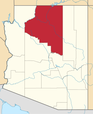 | |
| Towns | ||
| CDPs | ||
| Populated places |
| |
| Indian reservations | ||
| Ghost towns | ||
| Footnotes | ‡This populated place also has portions in an adjacent county or counties | |
| Authority control |
|
|---|