Morristown, Tennessee
Morristown is a city in and the county seat of Hamblen County, Tennessee, United States.[6] Morristown also extends into Jefferson County on the west and southern ends. The population was 29,137 at the 2010 United States Census.[7] It is the principal city of the Morristown Metropolitan Statistical Area, which encompasses all of Grainger, Hamblen, and Jefferson counties. The Morristown metropolitan area is also a part of the Knoxville-Sevierville-La Follette Combined Statistical Area.
Morristown, Tennessee | |
|---|---|
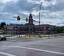
 Main Street in downtown Morristown as seen from the Skymart | |
 Seal | |
| Motto(s): "A City Always Expanding" | |
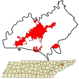 Location in Hamblen County and the state of Tennessee | |
| Coordinates: 36°12′38″N 83°17′46″W | |
| Country | United States |
| State | Tennessee |
| Counties | Hamblen, Jefferson |
| Settled | ca. 1787 |
| Incorporated | 1855[1] |
| Named for | Gideon Morris |
| Government | |
| • Type | Mayor-Council |
| • Mayor | Gary Chesney |
| • City Council | Council members
|
| Area | |
| • Total | 27.39 sq mi (70.94 km2) |
| • Land | 27.34 sq mi (70.81 km2) |
| • Water | 0.05 sq mi (0.12 km2) |
| Elevation | 1,350 ft (397 m) |
| Population (2010) | |
| • Total | 29,137 |
| • Estimate (2019)[3] | 30,193 |
| • Density | 1,094.55/sq mi (422.60/km2) |
| Time zone | UTC-5 (EST) |
| • Summer (DST) | UTC-4 (EDT) |
| ZIP codes | 37813-37816 |
| Area code(s) | 423 |
| FIPS code | 47-50280[4] |
| GNIS feature ID | 1269815[5] |
| Website | www |
History
Early settlement
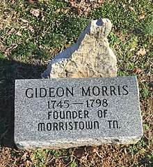
The first European settler of what eventually became Morristown was farmer Gideon Morris. It is recorded in Goodspeed's History of Tennessee that Gideon, along with an unspecified number of his siblings, arrived in the area of present-day Morristown from the Watauga Settlement, a short-lived semi-autonomous settlement located in northeast Tennessee that was originally leased from the resident Cherokee tribes during the 1770s.
Records in North Carolina indicate that a Morris family moved to the Watauga Settlement from North Carolina. According to Cora Davis Brooks, author of History of Morristown 1787-1936:
- "Gideon Morris was listed as one of the signers of the petition to annex Watauga to North Carolina in 1775, and in the Fall of the same year he served in Colonel Christian's expedition against the Indians. (N. C. Colonial Records, Vol. 10, p. 708) (King's Mountain Men by Miss Kate White.)"
In 1778 Gideon Morris appeared in court and swore allegiance ('History of South-west Virginia', by Summers). Lands were granted by the State of North Carolina to Gideon Morris in Washington, Greene and Hawkins counties. He probably settled on portions of these grants either in 1787 or 1791, which was included in Jefferson county and now in Hamblen county.
The settlement founded by Gideon has, as far as is known, always been called Morristown. No known records exist demonstrating land grants in the area to anyone aside from Gideon and his extended family. Jefferson County, located southwest of Hamblen County, possesses a record in the Jefferson County Court House of the results of the execution of Gideon Morris' will, which includes property deeded to John Morris in 1817 for a 400-acre (160 ha) tract of land originally granted to Gideon by the state of North Carolina, and presumably comprising only a portion of the original grant due to the known size of the Morris family at that time. Gideon Morris lived on that tract of land until his death.
The famous pioneer and folk-hero David Crockett lived in present-day Morristown when his father, John Crockett, established a tavern there in 1794. The current-day Crockett Tavern Museum sits at the approximate location of the former tavern. The museum is also listed on the National Register of Historic Places.[8]
Civil War

As the Civil War approached, the town's sympathies were divided between the Union and secessionist sides. In December 1863, some 25,000 Confederate Army soldiers under the command of General James Longstreet arrived at Bethesda Presbyterian Church, northeast of the town, to spend the winter, after the Battle of Bean's Station. They remained there until February 1864 and used the Bethesda Church building as a hospital.[9][10] Military engagements occurred near the church in both October and November 1864.[9] On October 28, 1864, Union General Alvan C. Gillem attacked Confederate forces under General John C. Vaughn in the Battle of Morristown. They fought in and around the town with Gillem routing Vaughn's Confederates in what became known as "Vaughn's Stampede." Vaughn was forced to retreat to Carter's Station on the Watauga River in northeastern Tennessee. The battle resulted in about 335 total casualties.[11][12][13] In the Battle of Bull's Gap ("Gillem's Stampede") in November, Confederate forces under General John C. Breckinridge prevailed over Gillem's troops, chasing the Union forces westward to a defensive position at Strawberry Plains near Knoxville.[13][14] During one of these skirmishes, a cannonball penetrated one of the church walls, causing structural damage that was repaired by reinforcing the walls with large iron rods.[9] The Union Army used the church as a hospital for soldiers wounded in these operations.[14] Many soldiers from both sides are interred in the Bethesda Church cemetery. Eighty of the wartime burials are unidentified.[9][10]
The Skymart and the present day

Morristown's Main Street area, measuring approximately 1 square mile (2.6 km2), arose from the intersection of two railroad lines. In 1962, Turkey Creek, which bisects the street, flooded and damaged the downtown commercial district. A suburban shopping mall on the city's west side also jeopardized businesses downtown, and the city developed a plan to modernize Main Street by creating an "overhead sidewalk", enabling businesses to form on the second floor of existing buildings while serving as a canopy for passage below. Building owners spent nearly $2 million ($16 million today) upgrading their properties and linking them to ramps, while the government contributed over $5 million to build the elevated walkways. The underground channel for Turkey Creek was also enlarged and rerouted. The project was completed in 1967; however, the Skymart has served as little more than a roof over the sidewalk and a remnant of the idealism of 1960s urban renewal projects. Despite the aftermath of the project, the overhead sidewalks still stand in the downtown area.
Morristown is embarking on a resurrection of the Skymart as a social and commercial hub. It has been made a key element in a greenway master plan for the region. In an effort to renew public interest, city officials, the Downtown Morristown Association, and the Morristown Area Chamber of Commerce hold events in the city's downtown or the "Skymart District" throughout the year, mainly during the warmer months of May to September.[15]
On March 22, 2016, Main Street and the rest of Morristown's downtown district was officially listed on The National Register of Historic Places.[16] The nearby Rose Center and Hamblen County Courthouse are both listed on the registry as well.
Geography
Morristown is located at coordinates 36°12′38″N 83°17′46″W (36.210615, −83.296141).[17] The city is 13 miles (21 km) northeast of Jefferson City, 10 miles (16 km) south of Bean Station, 30 miles (48 km) west of Greeneville, and 8 miles (13 km) north of White Pine. Morristown is bordered by the unincorporated communities of Russellville and Talbott.
According to the 2010 census, the city has a total area of 28.0 square miles (72.4 km2), of which 0.04 square miles (0.1 km2), or 0.19%, are water. Cherokee Lake, an artificial reservoir built by the Tennessee Valley Authority in the 1940s, is north of the city.
Neighborhoods
Airports
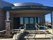
Morristown has a one airport and it is owned by the city. Morristown Regional Airport was founded in 1953 and was operated by female aviator Evelyn Johnson until her death in 2012. It is located four nautical miles (7 km) southwest of the central business district of Morristown.
Climate
Morristown falls in the humid subtropical climate zone (Köppen climate classification Cfa), although it is not quite as hot as areas to the south and west of Tennessee due to the higher elevations. Summers are hot and humid, with July highs averaging 85 °F (29 °C), lows averaging 66 °F (19 °C), and an average of eight days per year with temperatures above 90 °F (32 °C).[18] Winters are generally cool, with occasional small amounts of snow. January averages a high of around 45 °F (7 °C) and a low of around 28 °F (−2 °C), although low temperatures in the single digits and teens are not uncommon. The record high for Morristown, since 1994, is 103 °F (39 °C), while the record low is −2 °F (−19 °C). Annual precipitation averages around 44.3 in (1,125 mm), and average winter snowfall is 11.7 inches (30 cm). The average monthly relative humidity is around 70 percent.
| Climate data for Morristown, TN (since 1987) | |||||||||||||
|---|---|---|---|---|---|---|---|---|---|---|---|---|---|
| Month | Jan | Feb | Mar | Apr | May | Jun | Jul | Aug | Sep | Oct | Nov | Dec | Year |
| Record high °F (°C) | 77 (25) |
75 (24) |
86 (30) |
92 (33) |
93 (34) |
102 (39) |
103 (39) |
102 (39) |
103 (39) |
91 (33) |
84 (29) |
77 (25) |
103 (39) |
| Average high °F (°C) | 45 (7) |
50 (10) |
60 (16) |
68 (20) |
75 (24) |
82 (28) |
85 (29) |
85 (29) |
79 (26) |
69 (21) |
58 (14) |
48 (9) |
67 (19) |
| Daily mean °F (°C) | 37 (3) |
41 (5) |
49 (9) |
57 (14) |
65 (18) |
73 (23) |
76 (24) |
75 (24) |
69 (21) |
59 (15) |
48 (9) |
39 (4) |
57 (14) |
| Average low °F (°C) | 28 (−2) |
32 (0) |
38 (3) |
47 (8) |
54 (12) |
63 (17) |
66 (19) |
66 (19) |
59 (15) |
49 (9) |
39 (4) |
31 (−1) |
48 (9) |
| Record low °F (°C) | 1 (−17) |
−2 (−19) |
6 (−14) |
26 (−3) |
36 (2) |
43 (6) |
51 (11) |
49 (9) |
37 (3) |
25 (−4) |
5 (−15) |
4 (−16) |
−2 (−19) |
| Average precipitation inches (mm) | 4.2 (110) |
3.9 (99) |
4 (100) |
4 (100) |
4.2 (110) |
3.7 (94) |
5 (130) |
3.5 (89) |
3.1 (79) |
2.2 (56) |
3.5 (89) |
4 (100) |
44.3 (1,130) |
| Average snowfall inches (cm) | 3.9 (9.9) |
3.6 (9.1) |
1.5 (3.8) |
0.1 (0.25) |
0 (0) |
0 (0) |
0 (0) |
0 (0) |
0 (0) |
0 (0) |
0.2 (0.51) |
2.4 (6.1) |
11.7 (30) |
| Average relative humidity (%) | 73 | 69 | 65 | 62 | 67 | 70 | 72 | 72 | 69 | 70 | 69 | 72 | 69 |
| Source: Weatherbase.com[18] | |||||||||||||
Demographics
| Historical population | |||
|---|---|---|---|
| Census | Pop. | %± | |
| 1880 | 1,350 | — | |
| 1890 | 1,999 | 48.1% | |
| 1900 | 2,973 | 48.7% | |
| 1910 | 4,007 | 34.8% | |
| 1920 | 5,875 | 46.6% | |
| 1930 | 7,305 | 24.3% | |
| 1940 | 8,050 | 10.2% | |
| 1950 | 13,019 | 61.7% | |
| 1960 | 21,267 | 63.4% | |
| 1970 | 20,318 | −4.5% | |
| 1980 | 19,570 | −3.7% | |
| 1990 | 21,385 | 9.3% | |
| 2000 | 24,965 | 16.7% | |
| 2010 | 29,137 | 16.7% | |
| Est. 2019 | 30,193 | [3] | 3.6% |
| Sources:[19][20] | |||
As of the census of 2010,[4] there were 29,137 people, 11,412 households, and 7,278 families residing in the city. The population density was 1,194.7 people per square mile (461.2/km²). There were 12,705 housing units at an average density of 528.1 per square mile (203.9/km²). The racial makeup of the city was 86.52% White, 6.63% African American, 0.87% Asian, 0.20% Pacific Islander, and 2.15% from two or more races. Those of Hispanic or Latino origins were 19.37% of the population.
There were 11,412 households out of which 22.5% had children under 17 years of age living with them, 45.2% were married couples living together, 11.4% had a female householder with no husband present, and 36.2% were non-families. 31% of all households were made up of individuals and 11.0% had someone living alone who was 65 years of age or older. The average household size was 2.47 and the average family size was 3.07.
In the city, the population was spread out with 24.85% under 17 years of age, 9.45% from 18 to 24, 26.5% from 25 to 44, 23.2% from 45 to 64, and 16% who were 65 years of age or older. The median age was 36 years. For every 100 females, there were 91.2 males. For every 100 females age 18 and over, there were 91.9 males.
The median income for a household in the city was $27,005, and the median income for a family was $33,391. Males had a median income of $26,724 versus $20,515 for females. The per capita income for the city was $15,894. About 14.6% of families and 19.2% of the population were below the poverty line, including 24.9% of those under age 18 and 17.3% of those age 65 or over.
Government
City council
Morristown uses the mayor-council government system, which was established in 1855 when the city was incorporated. Morristown is governed by a seven-member city council composed of the mayor and six council members.[21] The citizens elect the mayor to a four-year term and the six council members to two-year terms.
State government
Morristown is represented in the Tennessee House of Representatives in the 10th district by Representative Rick Eldridge, a Republican.[22]
In the Tennessee State Senate, Morristown is represented by the 1st district by Senator Steve Southerland, also a Republican.[23]
National government
Morristown is represented in the United States House of Representatives by Republican Phil Roe of the 1st congressional district.[24]
Economy
Morristown is considered to be one of the largest manufacturing and industrial hubs in the state of Tennessee.[25] There are several industrial parks located in the eastern, western and southern parts of the city,[26] and over 100 manufacturers have based their facilities in Morristown, ranging from food processing, aerospace technology, machine and parts production, plastics engineering, and many other industries.[27]
Morristown's manufacturing market employs nearly 10,000 or 24% of the workforce in Hamblen County, and an extra 11,000 commuting from surrounding counties such as Jefferson, Grainger, Cocke, and Hawkins for employment.[28]
In popular culture
- The 1981 horror film The Evil Dead, had been filmed in neighboring Bean Station and in Morristown near Kidwell's Ridge Road. The cabin featured significantly in the film had burned down, with the only remains being bricks from the cabin's chimney.[29]
- The 2005 film Five Across the Eyes was filmed in Morristown.
Sports
Minor league baseball
Morristown hosted several Minor League Baseball teams from 1910 to 1961 at Sherwood Park.[30] The Morristown Jobbers became charter members of the Southeastern League in 1910.[31] The Jobbers continued in the Appalachian League in 1911 and, with the exception of a brief absence in 1913, played each season through 1914.[32] From 1923 to 1925, the city's entry in the league was called the Morristown Roosters.[31] In 1948, the Morristown Red Sox became charter members of the Mountain States League in which they played through 1954.[31] The team won the league championship in their first season.[33] The Red Sox folded early in the 1954 season and were replaced in the league by the Morristown Reds.[34][35] The Morristown Cubs, the city's final professional baseball team played in the Appalachian League from 1959 to 1961 and won the 1959 pennant.[31][36]
Walters State baseball
Walters State Community College's Senators baseball team has qualified in 8 JUCO world series tournaments and won 1 JUCO WORLD SERIES.
Little League
- In 1985 and 1987, Morristown had teams qualify for the Little League World Series; the 1985 team finished third. The Morristown teams are two of eight Tennessee teams that have advanced to the series in Williamsport, Pennsylvania.
- In 2006, Morristown placed fourth in the Little League Softball World Series.[37]
- In 2007, Morristown won the Little League Softball World Series.[38]
Notable people
- Ermal Allen, NFL football player and coach; 2x Super Bowl winner (VI, XII)
- Darrius Blevins, NFL player, St. Louis Rams; Super Bowl XXXIV winner
- Davy Crockett, pioneer; grew up in and around Morristown, born in nearby Greene County
- Mike Ford, former NASCAR crew chief for Denny Hamlin
- Elaine Hendrix, animal rights activist and award-winning TV/movie actress; attended middle and high school in Morristown
- Tim Horner, professional wrestler
- Evelyn Bryan Johnson, famous female aviator; former manager of Morristown Regional Airport
- Josiah Leming, contestant in the seventh season of American Idol who was eliminated in the top 50 but subsequently signed a recording contract with Warner Bros. Records[39]
- Brett Martin, professional baseball player
- William McFarland, U.S. congressman from 1875 to 1877 and Morristown mayor from 1882 to 1885
- Rickey Parkey, former IBF Cruiserweight champion
- Gideon Morris, trans-Appalachian pioneer and founder of Morristown
- Frankie Randall, boxing star first to beat Julio César Chávez; has held 3 world titles; was raised in Morristown
- Randy Sanders, former quarterback for Morristown East High School and the Tennessee Volunteers; currently head football coach for the East Tennessee State Buccaneers
- Dewitt Clinton Senter, governor of Tennessee (1869–1871)
- Joe Shipley, former professional baseball player and head coach of the East Tennessee State University baseball team
- James "Little Man" Stewart, NFL player from 1995 to 2003, for the Jacksonville Jaguars and Detroit Lions; was raised in Morristown and played for Morristown-Hamblen High School West and the University of Tennessee
- Uncle Am Stuart, early country music fiddle player
- The Talleys, Southern gospel group consisting of Roger and Debra Talley and their daughter Lauren Talley[40]
- Jane Wagner, playwright and actress who wrote The Search for Signs of Intelligent Life in the Universe
- Herbert S. Walters, Democratic United States Senator (1963–1964)
- Calvin Ward, soldier; Medal of Honor recipient
- John A. Willis, theatre and film book editor, theatre awards producer, actor, and educator. He is best known for editing the long-running annual publications Theatre World and Screen World.
Attractions
Historic sites

- Bethesda Presbyterian Church
- Crockett Tavern Museum
- General Longstreet's Headquarters Museum[41]
- Morristown Main Street Historic District[42]
- Morristown Cemetery
- The site of Morristown College, now Heritage Park
- Rose Center
Recreation and retail
- Parks and public recreation areas
- Panther Creek State Park
- Cherokee Park
- Public access to Cherokee Lake via swimming areas and boat launches
- Morristown City Parks and Recreation (15 locations including Civic, Fred Miller, Heritage, and Frank Lorino parks)[43]
- Disc Golf Courses
- Cherokee Park Disc
- Morristown Rotary Disc Course
- Kiwanis Disc Course
- Panther Creek State Park Disc Course
- Golf
- Morristown Golf and Country Club
- The Country Club
- Retail
- College Square Mall
- Shopping Complexes[44]
Education
Public schools
Public schools in Morristown are operated by the Hamblen County Department of Education. There are four middle schools: East Ridge, Lincoln, Meadowview, and Westview. Morristown has two high schools: Morristown-Hamblen High School East and Morristown-Hamblen High School West.[45]
Colleges
The main campus of Walters State Community College is located in Morristown.[46]
Satellite campuses of King University and Tusculum College are located in Morristown.
Media
Newspaper
- Citizen Tribune
References
- Morristown website Archived 2013-01-01 at the Wayback Machine. Retrieved January 16, 2013.
- "2018 U.S. Gazetteer Files". United States Census Bureau. Retrieved February 23, 2020.
- "Population and Housing Unit Estimates". Retrieved May 21, 2020.
- "U.S. Census website". United States Census Bureau. Retrieved 2008-01-31.
- "US Board on Geographic Names". United States Geological Survey. 2007-10-25. Retrieved 2008-01-31.
- "Find a County". National Association of Counties. Retrieved 2011-06-07.
- "Geographic Identifiers: 2010 Census Summary File 1 (G001): Morristown city, Tennessee". American Factfinder. U.S. Census Bureau. Archived from the original on February 13, 2020. Retrieved January 26, 2018.
- "Abbreviated History". CrockettTavernMuseum.org. Retrieved November 1, 2018.
- "Bethesda Presbyterian Church: A Church Divided". The Historical Marker Database. Retrieved January 12, 2014.
- McRary, Amy (April 1, 2012). "Bethesda Church was first a hospital, then a casualty". Knoxville News Sentinel.
- Campbell, S. (April 30, 2010). "The Battle of Morristown, 1864". Retrieved May 13, 2020.
- "Affair at Morristown". Tennessee Department of Tourist Development. Archived from the original on January 16, 2014. Retrieved January 13, 2014.
- Storie, Melanie (2013). The Dreaded 13th Tennessee Union Cavalry: Marauding Mountain Men. The History Press. pp. 72–75. ISBN 9781626191129.
- "Bethesda Church and Cemetery". Tennessee Department of Tourist Development. Archived from the original on January 16, 2014. Retrieved January 13, 2014.
- "Our Story | Historic Downtown Morristown, TN - Timeless Shopping. Dining. & Entertainment". downtownmorristown.city. Retrieved February 6, 2018.
- "Morristown Main Street Historic District". NPS.gov. Retrieved November 1, 2018.
- "US Gazetteer files: 2010, 2000, and 1990". United States Census Bureau. 2011-02-12. Retrieved 2011-04-23.
- "Morristown, Tennessee Travel Weather Averages (Weatherbase)". Weatherbase.
- "Census of Population and Housing: Decennial Censuses". United States Census Bureau. Retrieved 2012-03-04.
- "Incorporated Places and Minor Civil Divisions Datasets: Subcounty Resident Population Estimates: April 1, 2010 to July 1, 2012". Population Estimates. U.S. Census Bureau. Archived from the original on June 17, 2013. Retrieved December 11, 2013.
- City of Morristown. "Council". mymorristown.com. Retrieved June 9, 2020.
- State of Tennessee. "Representative Rick Eldridge". www.capitol.tn.gov. Retrieved June 9, 2020.
- State of Tennessee. "Senator Steve Southerland". www.capitol.tn.gov. Retrieved June 9, 2020.
- "Congressman Phil Roe Tennessee's 1st District – About the 1st District". Archived from the original on May 27, 2009.
- Morristown Area Chamber of Commerce. "Why Morristown?". selectmorristowntn.com. Retrieved June 7, 2020.
- City of Morristown. "East TN Progress Center Receives State Grant". mymorristown.com. Retrieved June 7, 2020.
- Morristown Area Chamber of Commerce. "Existing Industry". selectmorristowntn.com. Retrieved June 7, 2020.
- Morristown Area Chamber of Commerce. "Labor Market & Workforce". selectmorristowntn.com. Retrieved June 7, 2020.
- "The Evil Dead Cabin". Atlas Obscura. Retrieved June 7, 2020.
- "Sherwood Park". Stats Crew. Retrieved June 1, 2020.
- "Morristown, Tennessee Encyclopedia". Baseball-Reference. Sports Reference. Retrieved June 1, 2020.
- "Sports in Morristown, Tennessee". Stats Crew. Retrieved June 1, 2020.
- "1948 Mountain States League Standings". Stats Crew. Retrieved June 1, 2020.
- "Sox Officially Out of MSL". Morristown Sun. Morristown. May 19, 1954. p. 1 – via Newspapers.com.
- Hodges, Bill (June 20, 1954). "Morristown Back in MSL League". Morristown Gazette Mail. Morristown. p. 8 – via Newspapers.com.
- "Morristown Takes Flag". The Knoxville News-Sentinel. Knoxville. September 3, 1959. p. 32 – via Newspapers.com.
- 2006 Southern Region Champions Archived 2015-09-24 at the Wayback Machine. Retrieved July 1, 2014.
- LLSWS Past World Champions Archived 1998-05-24 at the Wayback Machine. Retrieved December 10, 2011.
- Terry Morrow, Local 'Idol' teen nabs major deal, Knoxville News Sentinel, July 3, 2008
- "The Talleys Official Website • Biography". www.thetalleys.com. Retrieved 2017-02-05.
- "General Longstreet Museum: Visit Us". Retrieved October 28, 2018.
- "History Heritage". Morristown Chamber of Commerce. Retrieved August 12, 2015.
- "Outdoor". Morristown Chamber of Commerce. Retrieved August 12, 2015.
- "Where to Shop". Morristown Chamber of Commerce. Retrieved August 12, 2015.
- "Schools". Hamblen County Department of Education. Retrieved August 12, 2015.
- "Campuses". ws.edu. Retrieved October 28, 2018.
Further reading
- Brooks, Cora Davis. "History of Morristown 1787 - 1936" 1936.
- Hill, Howard. "The Morristown-Hamblen Library"
- Hobby, Larry. "Morristown" Arcadia Publishing 2013
External links
| Wikimedia Commons has media related to Morristown, Tennessee. |
- Official website
- Morristown Area Chamber of Commerce
- The Morristown-Hamblen Public Library website
- Morristown, Tennessee at Curlie
- Morristown Area Chamber of Commerce Travel and Tourism
Municipalities and communities of Hamblen County, Tennessee, United States | ||
|---|---|---|
| City | ||
| Town | ||
| Unincorporated communities | ||
| Footnotes | ‡This populated place also has portions in an adjacent county or counties | |
Municipalities and communities of Jefferson County, Tennessee, United States | ||
|---|---|---|
| Cities | ||
| Towns | ||
| Unincorporated communities | ||
| Footnotes | ‡This populated place also has portions in an adjacent county or counties | |
| Principal City |   | |
|---|---|---|
| Other Cities | ||
| Counties | ||
| Authority control |
|
|---|