Gorumna
Gorumna (Irish: Garmna) is an island on the west coast of Ireland, forming part of County Galway.
| Native name: Garmna | |
|---|---|
_island_-_geograph.org.uk_-_1249945.jpg) Droim Quay at south end of Garmna | |
 Gorumna | |
| Geography | |
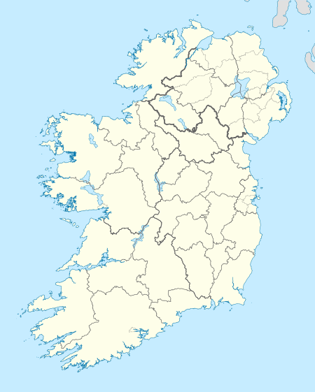
| Location | Atlantic Ocean |
| Coordinates | 53.25°N 9.68°W |
| Administration | |
| Province | Connacht |
| County | Galway |
| Demographics | |
| Population | 1055 (2011) |
_island_church_-_geograph.org.uk_-_1250168.jpg)
Garmna island church
Geography
Gorumna Island is linked with the mainland through the Béal an Daingin Bridge. Gorumna properly consists of three individual islands in close proximity, Lettermullen, Teeranea (Irish: Tír an Fhia) and Lettermore.[1]
Geology
Gorumna Island is mostly underlain by intrusive Devonian-aged Galway Granite that formed from crustal melting as a result of the Caledonian Orogeny in the late Silurian. It's southern tip also includes Ordovician-aged bedrock of sedimentary marine rocks and basalt.[2]
Demographics
The table below reports data on Gorumna Island's population taken from Discover the Islands of Ireland (Alex Ritsema, Collins Press, 1999) and the census of Ireland.
| Historical population | |||||||||||||||||||||||||||||||||||||||||||||||||||||||||||||||||||||||||||||||||||
|---|---|---|---|---|---|---|---|---|---|---|---|---|---|---|---|---|---|---|---|---|---|---|---|---|---|---|---|---|---|---|---|---|---|---|---|---|---|---|---|---|---|---|---|---|---|---|---|---|---|---|---|---|---|---|---|---|---|---|---|---|---|---|---|---|---|---|---|---|---|---|---|---|---|---|---|---|---|---|---|---|---|---|---|
|
|
| |||||||||||||||||||||||||||||||||||||||||||||||||||||||||||||||||||||||||||||||||
| Source: Central Statistics Office. "CNA17: Population by Off Shore Island, Sex and Year". CSO.ie. Retrieved 12 October 2016. | |||||||||||||||||||||||||||||||||||||||||||||||||||||||||||||||||||||||||||||||||||
References
- "Gorumna Island". Mapcarta. Retrieved 17 June 2020.
- Holland, C. H. (Charles Hepworth) Sanders, Ian. (2009). The geology of Ireland. Dunedin Academic. ISBN 978-1-903544-49-5. OCLC 679356088.CS1 maint: multiple names: authors list (link)
Other projects

Places in County Galway | ||
|---|---|---|
| Towns | 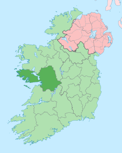 | |
| Villages |
| |
| Townlands | ||
| Baronies | ||
| Islands | ||
| ||
This article is issued from Wikipedia. The text is licensed under Creative Commons - Attribution - Sharealike. Additional terms may apply for the media files.