Connemara
Connemara (Irish: Conamara [ˌkʊnˠəˈmˠaɾˠə]) is a cultural region in County Galway, Ireland. The area has a strong association with traditional Irish culture and contains a major part of the Connacht Irish-speaking Gaeltacht, which is a key part of the identity of the region and is the largest Gaeltacht in the country.

Etymology
"Connemara" derives from the tribal name Conmacne Mara, which designated a branch of the Conmacne, an early tribal grouping that had a number of branches located in different parts of Connacht. Since this particular branch of the Conmacne lived by the sea, they became known as the Conmacne Mara (sea in Irish is muir, genitive mara, hence "of the sea"). The area in the east of what is now Connemara was called Delbhna Tír Dhá Locha.
Definition
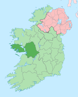
One common definition of the area is that it consists of most of West Galway, that is to say the part of the county west of Lough Corrib and Galway city, contained by Killary Harbour, Galway Bay and the Atlantic Ocean.[1] Some more restrictive definitions of Connemara define it as the historical territory of Conmhaícne Mara, i.e. just the far northwest of County Galway, bordering County Mayo. The name is also used to describe the Gaeltacht (Irish-speaking areas) of western County Galway, though it is argued that this too is inaccurate as some of these areas lie outside of the traditional boundary of Connemara.[2] There are arguments about where Connemara ends as it approaches Galway city, which is definitely not in Connemara — some argue for Barna, on the outskirts of Galway City, some for a line from Oughterard to Maam Cross, and then diagonally down to the coast, all within rural lands.
The wider area of what is today known as Connemara was previously a sovereign kingdom known as Iar Connacht, under the kingship of the Ó Flaithbertaigh, until it became part of the English-administered Kingdom of Ireland in the 16th century.
Geography
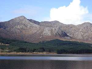
Connemara lies in the territory of Iar Connacht, "West Connacht," within the portion of County Galway west of Lough Corrib, and was traditionally divided into North Connemara and South Connemara. The mountains of the Twelve Bens and the Owenglin River, which flows into the sea at An Clochán / Clifden, marked the boundary between the two parts. Connemara is bounded on the west, south and north by the Atlantic Ocean. In at least some definitions, Connemara's land boundary with the rest of County Galway is marked by the Invermore River otherwise known as Inbhear Mór[3] (which flows into the north of Kilkieran Bay), Loch Oorid (which lies a few kilometres west of Maam Cross) and the western spine of the Maumturks mountains. In the north of the mountains, the boundary meets the sea at Killary, a few kilometres west of Leenaun.

The coast of Connemara is made up of multiple peninsulas. The peninsula of Iorras Ainbhtheach (sometimes corrupted to Iorras Aithneach) in the south is the largest and contains the villages of Carna and Kilkieran. The peninsula of Errismore consists of the area west of the village of Ballyconneely. Errisbeg peninsula lies to the south of the village of Roundstone. The Errislannan peninsula lies just south of the town of Clifden. The peninsulas of Kingstown, Coolacloy, Aughrus, Cleggan and Renvyle are found in the north-west of Connemara. Of the numerous islands off the coast of Connemara, Inishbofin is the largest; other islands include Omey, Inishark, High Island, Friars Island, Feenish and Maínis.
The territory contains the civil parishes of Moyrus, Ballynakill, Omey, Ballindoon and Inishbofin (the last parish was for a time part of the territory of the Clann Uí Mháille, the O Malleys of the territory of Umhall, County Mayo), and the Roman Catholic parishes of Carna, Clifden (Omey and Ballindoon), Ballynakill, Kilcumin (Oughterard and Rosscahill), Roundstone and Inishbofin.
History
The Ó Cadhla (Kealy) clan were the rulers of Connemara up until the 13th century, when they were displaced by the Ó Flaithbertaighs. The latter had fled into Iar Connacht from Maigh Seola during the Anglo-Norman invasion of Connacht during the early 13th century.[4]
Like the Ó Cadhla clan, the Mac Conghaile (Conneely) clan was also a branch of the Conmhaícne Mara.
The main town of Connemara is Clifden. The area around the town is rich with megalithic tombs. The famous "Connemara Green marble" is found outcropping along a line between Streamstown and Lissoughter. It was a trade treasure used by the inhabitants of the prehistoric time. It continues to be of great value today. It is available in large dimensional slabs suitable for buildings as well as for smaller pieces of jewellery. It is used for the pendant for the Chief Scout's Award, the highest award in Scouting Ireland.
Connemara was drastically depopulated during the Great Famine in the late 1840s, with the lands of the Anglo-Irish Martin family being greatly affected and the bankrupted landlord being forced to auction off the estate in 1849:[5]
As that year of 1847 had been the worst of several consecutive years of famine, it was to be understood that those missing tenants had abandoned their holdings to crowd into the workhouses or the emigrant ships to the New World, or they were dead; in any case they no longer infested the ground, which was left as a blank canvas on which Capital could paint a fair and profitable landscape.
The first transatlantic flight, piloted by Alcock and Brown, landed in Clifden in 1919.[6]
Transport
Connemara is accessible by the Bus Éireann and City Link bus services. From 1895 to 1935 it was served by the Midland Great Western Railway branch that connected Galway City to Clifden.
The N59 is the main area road, following an inland route from Galway to Clifden. A popular alternative is the coastal route beginning with the R336 from Galway. This is also known as the Connemara Loop[7] consisting of a 45 km drive where one can view the landscape and scenery of Connemara.
Aer Arann Islands serves the Aran Islands from Connemara Airport in the south of Connemara also known as Aerfort na Minna.
Irish language
The population of Connemara is 32,000. There are between 20,000–24,000 native Irish speakers in the region making it the largest Irish-speaking Gaeltacht.
The Enumeration Districts with the most Irish speakers in all of Ireland as a percentage of the population can be seen in the South Connemara area.
Most Irish speakers are of school age (5–19 years old).[8]
Notable towns and villages
These settlements are within the most extensive definition of the area. More restrictive definitions will exclude some:
- Barna - (Bearna)
- Ballyconneely - (Baile Conaola / Baile Mhic Chonghaile)
- Ballynahinch - (Baile na hInse)
- Carna - (Cárna)
- Carraroe - (An Cheathrú Rua)
- Claddaghduff - (An Cladach Dubh)
- Cleggan - (An Cloigeann)
- Clifden - (An Clochán)
- Inverin - (Indreabhán)
- Kilkerren - (Cill Chiaráin)
- Leenaun - (An Lionán / Leenane)
- Letterfrack - (Leitir Fraic)
- Lettermore - (Leitir Móir)
- Lettermullan - (Leitir Mealláin)
- Maum - (An Mám, also Maam)
- Oughterard - (Uachtar Ard)
- Recess - (Sraith Salach)[9]
- Renvyle - (Rinn Mhaoile)
- Rosmuc - (Ros Muc)
- Rossaveal – (Ros an Mhíl)
- Roundstone - (Cloch na Rón)
- Spiddal - (An Spidéal)
Notable islands
- Omey Island - (Iomaidh)
- Inishbofin - (Inis Bó Finne) has been home to fishermen, farmers, exiled monks and fugitive pirates for over 6,000 years and today the island supports a population of 200 full-time residents.
Curiosities
- Connemara Wedding is a poem written by Micheál Mac Suibhne (c. 1760–1820)
- French singer Michel Sardou had an international hit with the song "Les Lacs du Connemara" in 1981.
- The Irish drinking song "The Hills of Connemara" has been recorded and performed by a number of Irish and Celtic-themed bands.
- Poet Carl Sandburg's home of 22 years in Flat Rock, North Carolina, which is now a national monument, is named after the Connemara region.
- Conamara Chaos is a region of chaotic terrain on Jupiter's moon Europa.
- The Connemara pony is a breed of horse native to the region.
- Connemara is also the name of a brand of Irish whiskey produced at the Cooley Distillery.
Annalistic references
- 807. A slaughter was made of the Conmaicni by the foreigners.
Notable people associated with Connemara
- John Ford, the American film director, and winner of 4 Academy Awards, whose real name was Sean O'Feeney, was the son of John Augustine Feeney from Spiddal, and directed the classic film The Quiet Man in nearby Cong, County Mayo.
- Máire Geoghegan-Quinn is an Irish politician, and was the former European Commissioner for Research, Innovation and Science was born in Carna.
- Richard Martin, MP, known as "Humanity Dick", was born in Ballynahinch Castle, Ballynahinch and represented Galway in the House of Commons.
- Michael Morris, 3rd Baron Killanin, was president of the International Olympic Committee (IOC), and lived at the family seat in Spiddal.
- Patrick Nee, Irish-born American mobster in South Boston, member of the Mullen Gang and associate of Irish American mobster Whitey Bulger.
- Máirtín Ó Cadhain was one of the most prominent Irish language writers of the 20th century, and wrote the Irish language classic Cré na Cille, was born in Connemara.
- Peter O'Toole, the noted actor of stage and screen, who achieved stardom in 1962 playing T.E. Lawrence in Lawrence of Arabia, was born in Connemara in 1932, according to accounts of his life.
- Pádraig Pearse who was one of the leaders of the Easter Rising in 1916, owned a cottage in Rosmuc, where he spent his summers learning the Irish language and writing.
- Maharaja Jam Sahib of Nawanagar, an Indian prince and cricket player, was the first head of state to make an official visit to the newly founded Irish Free State, bought Ballynahinch Castle estate and visited the area every year till his death in 1932.
- John Riley (soldier) Irish-American soldier who defected from the US Army and formed the Saint Patrick's Battalion to fight for Mexico.
- Tim Robinson, a cartographer, has lived many years in Connemara and published books on the area.
- Gráinne Seoige, the Irish TV presenter and journalist, who has worked for TG4, RTÉ, Sky News Ireland and the BBC, is a native of Spiddal.
- Mairtin Thornton was a heavyweight boxer, nicknamed the "Connemara Chrusher", he was the Irish Heavyweight boxing champion in 1943, and fought Bruce Woodcock for the British heavyweight title in 1945.
- J. Bruce Ismay, Chairman of the White Star Line, which owned the Titanic, lived for part of his later life in his lodge in Connemara. Ismay was on board the Titanic when it sank but was one of the survivors.[10]
- Sean Mannion, a professional boxer who boxed out of Massachusetts and fought for the WBA, was born in Rosmuc.
- Claire Hanna, SDLP MP in Westminster was born here.[11]
Connemara in media
Film and TV
- The Quiet Man, 1952, film by John Ford
- The Field, 1990, film by Jim Sheridan
- The Guard, 2011, film by John Michael McDonagh
- Black '47, 2018, film by Lance Daly
Theatre and literature
- The Beauty Queen of Leenane, 1996, play by Martin McDonagh
- Star of the Sea, 2011, novel by Joseph O'Connor
- The Crow of Connemara, 2015, novel by Stephen Leigh
- Secrets of the Lighthouse, 2015, by Santa Montefiore
- The Sweet-Maker of Connemara, 2019, novel by Daniel Martin Eckhart
See also
| Wikimedia Commons has media related to Connemara. |
| Wikivoyage has a travel guide for Connemara. |
- Alcock and Brown's first non-stop flight across the Atlantic crash landed near Clifden
- Ceantar na nOileán
- Connacht Irish
- Connemara Heritage & History Centre
- Connemara National Park
- Joyce Country
- Lough Corrib
- The Twelve Pins and Maumturks mountains
- The Western Way (Long-distance trail)
- The Connemara Pony
- Wild Atlantic Way
References
- A Chorographical Description of West or H-Iar Connaught written A.D. 1684 by Roderic O'Flaherty ESQ with notes and Illustrations by, James Hardiman M.R.I.A., Irish Archaeological Society, 1846.
- "Connemara Ireland, what to see in Connemara, map of the Connemara loop, things to do and beaches". Galway Tourism. Retrieved 13 April 2016.
- "Connemara Ireland". connemaraireland.com. Retrieved 30 November 2016.
- "Full Result". places.galwaylibrary.ie. Retrieved 13 April 2016.
- "History". Go Connemara. Retrieved 13 April 2016.
- "Connemara after the Famine". History Ireland. 12 April 2013. Retrieved 7 April 2019.
- "Captain John Alcock and Lieutenant Arthur Whitten Brown". aviation-history.com. Retrieved 14 April 2016.
- http://www.goconnemara.com/
- "Census 2011: Diversity Ethnicity Languages" (PDF). Irish Census. 2011. Retrieved 13 April 2016.
- Ordnance Survey of Ireland map 44 spells it Sraith Salach.
- "J. Bruce Ismay, 74, Titanic Survivor. Ex-Head of White Star Line Who Retired After Sea Tragedy Dies in London". The New York Times. 19 October 1937. "Joseph Bruce Ismay, former chairman of the White Star Line and a survivor of the Titanic disaster in 1912, died here last night. He was 74 years old."
- About Claire
External links
- Connemara after the Famine at History Ireland
- Love Connemara - Visitor Guide to the Connemara Region