Geography of Suriname
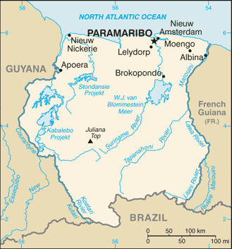
Suriname is located in the northern part of South America and is part of Caribbean South America, bordering the North Atlantic Ocean, between French Guiana and Guyana. It is mostly covered by tropical rainforest, containing a great diversity of flora and fauna that, for the most part, are increasingly threatened by new development. There is a relatively small population, most of which live along the coast.
 | |
| Continent | South America |
|---|---|
| Region | Caribbean |
| Coordinates | 4°00′N 56°00′W |
| Area | Ranked 90th |
| • Total | 163,820 km2 (63,250 sq mi) |
| • Land | 95.33% |
| • Water | 4.67% |
| Coastline | 386 km (240 mi) |
| Borders | total length 1,707 km (1,061 mi) |
| Highest point | Juliana Top 1,230 meters (4,040 ft) |
| Lowest point | Caribbean Sea 0 metres (0 ft) |
| Longest river | Courantyne River 724 km (450 mi) |
| Largest lake | Brokopondo Reservoir 1,560 km (970 mi) |
| Exclusive economic zone | 127,772 km2 (49,333 sq mi) |
Location
Geographic coordinates: 4°00′N 56°00′W
Continent: South America
Area
Total:
163,820 square kilometers (63,250 sq mi)
Land:
156,000 square kilometers (60,000 sq mi)
Water:
7,820 square kilometers (3,020 sq mi)
Area - comparative: See order of magnitude 1 E+11 m². Slightly larger than the US state of Georgia.
Land boundaries
Total: 1,703 kilometers (1,058 mi)
Border countries:
- Brazil - 593 kilometers (368 mi)
- French Guiana - 510 kilometers (320 mi)
- Guyana - 600 kilometers (370 mi)
Coastline: 386 kilometers (240 mi)
Maritime claims
Exclusive economic zone: 127,772 km2 (49,333 sq mi) and 200 nmi (370.4 km; 230.2 mi)
Territorial sea: 12 nmi (22.2 km; 13.8 mi)
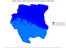
Climate and terrain
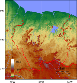
Terrain
Most of the country is made up of rolling hills, but there is a narrow coastal plain that has swampy terrain.
Elevation extremes
Lowest point: Unnamed location in the coastal plain - 2 meters (6.6 ft) below Sea Level.
Highest point: Juliana Top - 1,230 meters (4,040 ft)
Natural resources
Timber, hydropower, fish, forests, hydroelectric potential, kaolin, shrimp, bauxite and gold. Small amounts of nickel, copper, platinum and iron ore. It also has sizeable oil.
Water
The country has one large reservoir, the Brokopondo Reservoir. Several rivers run through it, including the Suriname River, Nickerie River and Maroni or Marowijne River.
Land use
(2005 Estimates)
Arable land:
0.36%
Permanent crops:
0.06%
Other:
99.58%
Irrigated land
510 square kilometers (200 sq mi) (2003)
Natural hazards
Tropical Showers, no hurricanes.
Environment
Current issues
Deforestation is a real problem as timber is cut for export. There is also a lot of pollution of inland waterways by small-scale mining activities.
Climate change
Suriname is already seeing the effects of climate change, including warming temperatures and more extreme weather events. As a relatively poor country, its contributions to climate change have been limited; moreover, because of the large forest cover the country has been running a carbon-negative economy since 2014.[1]
Suriname was the second country to update its Nationally Determined Contributions in 2020.[2]International agreements
Suriname has agreed to the following agreements: Biodiversity, Climate Change, Endangered Species, Law of the Sea, Marine Dumping, Ozone Layer Protection, Ship Pollution, Tropical Timber 94, Wetlands, Whaling
Extreme points
- Northernmost point – Oostelijke Polders
- Southernmost point – Border with Brazil Coeroeni
- Westernmost point – Border with Guyana, Sipaliwini District
- Easternmost point – Border with French Guiana, Sipaliwini District
- Highest point – Julianatop: 1,230 m
- Lowest point – unnamed location on the coastal plain: -2 m
External links
- "Guyana, or, the Kingdom of the Amazons" is a map from the 1600s of what is now known as Suriname
| History |  | ||||
|---|---|---|---|---|---|
| Geography |
| ||||
| Politics |
| ||||
| Economy |
| ||||
| Society |
| ||||
- "Suriname's climate promise, for a sustainable future". UN News. 2020-01-31. Retrieved 2020-06-07.
- "Suriname's Second National Communication - In Progress | UNDP Climate Change Adaptation". www.adaptation-undp.org. Retrieved 2020-06-07.