Climate of Peru
The climate of Peru is very diverse, with a large variety of climates and microclimates, including 28 of the 32 world climates. Such a diversity is chiefly conditioned by the presence of the Andes mountains and the cold Humboldt Current.
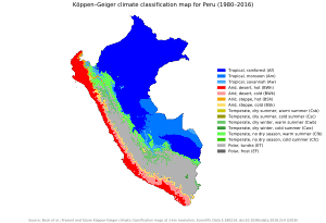
The climate on the coast is arid to semi-arid and hot, and has very little rainfall. The Andes mountains observe a temperate-to-cold climate with rainy summers and very dry winter. The eastern lowlands present an Equatorial climate with hot weather and rain distributed all year long
Pacific coast
The climate of the coast ranges from warm-semiarid (north of 10°S, and thus very close to the equator) to a climate which is a bit like the Mediterranean (Köppen Csb) climate with an important difference — the winter, although cloudy and cool, does not have sufficient rainfall to be considered a Köppen C climate.
The high coastal climate is mostly determined by the influence of the cold Humboldt Current, which runs parallel to the Peruvian coast, blocking the possibility of precipitation coming from the Ocean. Should this current be warm instead, the presence of the Andes would suffice for high amounts of orographic precipitation, such as registered in the top north and south part of the South American coastal Andes.
Northern coast
The temperature extremes of the northern coast (3°S–6°S) range from 30 to 38 °C (86.0 to 100.4 °F). Summers are characterized by hot and sunny conditions, with occasional afternoon and nocturnal light rainshowers. The farther north, the less arid, due to the Humboldt Current getting less cold as it nears the Equator. Thus, the Tumbes Region, bordering Ecuador, is the only coastal one with regular seasonal precipitation.
Summer rainfall totals rarely exceed 210 mm (8.3 in), save for severe El Niño events, which can provoke major floodings, with precipitations which can be as high as 4,500 mm (177.2 in), especially in the readings observed over the entire Peruvian coast; the aforementioned Tumbes region and Piura are the hottest. Winter is characterized by warm yet comfortable conditions and absence of rain.
Central and southern coast
In the central and southern coasts (south of 6°S) temperature ranges from 8 to 30 °C (46.4 to 86.0 °F) and rainfall is scarce with annual totals are 150 mm. Summer is characterized by warm, moist and sunny conditions with lows between 20 and 22 °C (68.0 and 71.6 °F) and highs are between 24 and 29 °C (75.2 and 84.2 °F). Temperatures over 29 °C (84 °F) are commonly observed less than 12 days per year except at the Ica deserts where summer highs can sometimes reach 35 °C (95 °F). Little or no rainfall occurs during the summer. Very rare rainfall events are produced by the leftovers of Andean convection and occur during the night. Summer rainfall totals are generally less than 10 mm (0.4 in).
Winter is characterized by overcast, cool and damp conditions, which keep daytime temperatures cool. Strictly by the coast and a few kilometers inland, winter is determined by an almost permanent layer of fog, which creates garua, a particular mist own to coastal Peru and Chile. In those areas located right by the ocean, the so-called 'rainy season' develops by late May and comes to an end by mid October. Precipitation occurs in the form of nocturnal-morning drizzle and seasonal totals range between 10 and 150 mm (0.4 and 5.9 in). Winter precipitation favors the development of vegetation over particular coastal mountain ranges known as "Lomas". The desert green-up peaks between July and early November.
Temperatures range from 14–18 °C (57.2–64.4 °F) at night and 19–21 °C (66.2–69.8 °F) during the day. Winter highs oscillate between 15 and 21 °C (59.0 and 69.8 °F) and the lows between 8 and 15 °C (46.4 and 59.0 °F). Several weeks of persistent overcast skies and highs below 19 °C (66.2 °F) are not uncommon between July and September.
Some representative weather station averages:
- Piura (north); 55 m (180 ft); annual mean temperature 24.4 °C (75.9 °F); annual mean precipitation 72 mm (2.8 in) Climate type BWh (hot desert).
- Lima, (central); 30 m (98 ft); annual mean temperature 19.2 °C (66.6 °F); annual 15 mm (0.6 in), Climate type BWh ("subtropical" desert, but cold Humboldt Current generates fog).
- Lomas de Lachay, Huaral Province in Lima, a unique mist-fed ecosystem.
Andean highlands
The Peruvian Andes (clima de Sierra in Spanish) exhibits the largest diversity among the country. Temperature is proportional to altitude, varying from temperate (annual average of 18 °C or 64 °F) in the low-lying valleys to frigid (annual average below 0 °C or 32 °F) in the highest elevations. The maximum temperature is often steady throughout the year, the low varying due to the presence of clouds in the monsoonal period, which help keeping to some extent the daytime heat during the night. In the absence of clouds, nights are much colder.
| Cuzco, Peru | ||||||||||||||||||||||||||||||||||||||||||||||||||||||||||||
|---|---|---|---|---|---|---|---|---|---|---|---|---|---|---|---|---|---|---|---|---|---|---|---|---|---|---|---|---|---|---|---|---|---|---|---|---|---|---|---|---|---|---|---|---|---|---|---|---|---|---|---|---|---|---|---|---|---|---|---|---|
| Climate chart (explanation) | ||||||||||||||||||||||||||||||||||||||||||||||||||||||||||||
| ||||||||||||||||||||||||||||||||||||||||||||||||||||||||||||
| ||||||||||||||||||||||||||||||||||||||||||||||||||||||||||||
Precipitation varies in different scales and has a marked seasonality. The warm spring starts in September but rainfall peaks between October and March, whereas the May–August part of the year is characterized by strong insolation, very dry conditions and cold nights and mornings, which is almost the exact reverse, in terms of insolation, to the coast climate. There is a marked southwest-northeast rainfall gradient with the driest conditions (200–500 mm or 7.9–19.7 in per year) along the southwestern Andes, and the wettest conditions along the eastern slopes (>1,000 mm or 39.4 in per year). Upon the interaction between the topography and the mean flow, some regions immediately east of the Andes can receive as much as 10,000 mm (393.7 in) per year. Rainfall is also larger over mountain ranges than over valley floors, since most of the rainfall occurs in the form of afternoon convective storms. Lakes also modulate the distribution and rainfall amounts. Lake Titicaca, for example, induces nocturnal convective storms that produce twice as much rainfall over the lake than over the surrounding terrain. Occasionally thunderstorms can be accompanied by frequent cloud to ground lightning, strong winds and damaging hail, especially during the onset of the humid summer and over higher elevations. Snowfall is frequent above 5,000 m (16,404 ft) during the winter, and occasional above 3,800 m (12,467 ft) between April and September.
Some representative averages
- Chachapoyas, Peru; 2,435 m (7,989 ft); annual mean temperature 15.3 °C (59.5 °F); annual mean precipitation 796 mm (31.3 in), Climate type Cwb.
- Cuzco, Peru; 3,249 m (10,659 ft); annual mean temperature 12.5 °C (54.5 °F); annual mean precipitation 736 mm (29 in), Climate type Cwb.[1]
Eastern lowlands
The eastern lowlands are characterized by the Equatorial climate which feeds the Amazon Rainforest. The climate of this region is hot and rainy most of the year. Temperatures oscillate between 18–36 °C (64.4–96.8 °F) most of the year and rainfall varies between 1,000 and 4,000 mm (39.4 and 157.5 in) per year. South of 8°S, a short dry season occurs between June and August. Occasional cold surges that originate over Argentina may lower the temperature to 10–15 °C (50–59 °F). These events occur 1–5 times per year between May and September.
Some representative averages:
- Iquitos, Peru; 126 m (413 ft), annual mean temperature 26.2 °C (79.2 °F); annual mean precipitation 2,853 mm (112.3 in), Climate type Af.
- Yurimaguas, Peru; 184 m (604 ft); annual mean temperature 26.9 °C (80.4 °F); annual mean precipitation 2,047 mm (80.6 in), Climate type Af.[1]
Extremes
2009 winter
From April to July 2009, unusually cold weather resulted in the deaths of more than 100 children under the age of five.[2] In June, there were 50,000 suffering from acute respiratory infections, and 4,851 with pneumonia. Between mid April and mid June, 61 children perished.[3] The United Nations Population Fund reported over 13,500 cases of pneumonia, and more than 60,000 cases of respiratory infections. The Adventist Development and Relief Agency (ADRA) is distributing blankets and warm clothing. Whereas pneumonia cases resulting in death of infants (who are often underclothed, if not barefoot) are the norm during winter, the 2009 winter season was unusual in that it began 12 weeks earlier than usual. More than 80 of the deaths occurred in Puno, Peru, one of the larger cities of the Altiplano lying in the central Andes. The children suffering from malnourishment are the population at greatest risk in an impoverished southern area of Peru lacking health care facilities.[2][4]
Yehude Simon, presidential Cabinet Chief, reported that 27 million S/ or US$9 million was allotted for Puno and 23,230 vaccine doses were shipped out. Oscar Ugarte, the Health Minister reported that only 234 of these vaccines were administered. Carmen Vildoso, Minister of Women's Affairs, is working at developing a program to create solar panel-heated walls in residential homes to provide heating.
In June, Percy Zaga Bustinza, Director of Puno's Social Development, reported that a new Pinaya health centre would be opening up and also a small hospital in Santa Lucia. UNICEF would like action taken so that the deaths from the predictable cold weather can be prevented. As well, preventative measures should be put in place so that the cold weather no longer results in an emergency situation.[5] School hours were modified for the children's school days so they are not out in the coldest part of the day. By the middle of June, livestock and crops had been adversely affected by the cold weather across 92,000 hectares (227,337 acres) of land. In July 2009, a state of emergency was declared by President of Peru Alan García Pérez in 11 regions of Peru: Apurímac, Arequipa, Ayacucho, Cusco, Huancavelica, Junín, Lima, Moquegua, Pasco, Puno and Tacna.[3] The cold winter weather is expected to end in September.[3]
2010 state of emergency
In July 2010, the Peruvian government declared a state of emergency in 16 of Peru's 24 regions due to cold weather. The majority of the areas affected were in the south, where temperatures dropped to as low as -24C. Lima recorded its lowest temperatures in 38 years at 9C, and emergency measures were applied to several of its outlying districts. In the Amazon region, temperatures dropped to as low as 9C, the fifth recorded cold spell that year. In the south, hundreds of people - nearly half of them very young children - were reported as having died of cold-related diseases such as pneumonia, and poor rural populations living at more than 3,000m above sea level were the most affected.[6]
References
- http://www.klimadiagramme.de/
- Collyns, Dan (12 July 2009). "Almost 250 children under the age of five have died in a wave of intensely cold weather in Peru". BBC News. Retrieved 2009-07-12.
- "Peru declares state of emergency due to record-breaking cold spell". Peruvian Times. June 19, 2009. Retrieved 2009-07-12.
- "Deadly Cold Wave Brings Misery to Southern Peru". Reuters. Alert Net. 8 Jul 2009. Retrieved 2009-07-12.
- "Puno Regional President accused of negligence in child deaths from cold". Peruvian Times. June 6, 2009. Retrieved 2009-07-13.
- "Peru declares emergency over cold weather". BBC News. July 24, 2010. Retrieved 2010-07-24.