Göynücek
Göynücek is a town and district of Amasya Province, lying just to the north of central Turkey, in the middle of the provinces of Tokat, Çorum and Yozgat. It covers an area of 578 km², and the population is 11,952 of which 2,325 live in the town of Göynücek, the majority spread throughout the surrounding countryside. Göynücek sits in the valley of the River Çekerek. The mayor is Kemal Şahin (AKP).
Göynücek | |
|---|---|
 Göynücek | |
| Coordinates: 40°23′N 35°31′E | |
| Country | Turkey |
| Province | Amasya |
| Government | |
| • Mayor | Kemal Şahin (AKP) |
| Area | |
| • District | 578.15 km2 (223.22 sq mi) |
| Population (2012)[2] | |
| • Urban | 2,525 |
| • District | 11,432 |
| • District density | 20/km2 (51/sq mi) |
Climate
Göynücek has a hot-summer Mediterranean climate (Köppen: Csa).
| Climate data for Göynücek | |||||||||||||
|---|---|---|---|---|---|---|---|---|---|---|---|---|---|
| Month | Jan | Feb | Mar | Apr | May | Jun | Jul | Aug | Sep | Oct | Nov | Dec | Year |
| Daily mean °C (°F) | 1.9 (35.4) |
3.7 (38.7) |
7.8 (46.0) |
12.7 (54.9) |
16.6 (61.9) |
19.9 (67.8) |
22.4 (72.3) |
22.5 (72.5) |
18.8 (65.8) |
13.8 (56.8) |
8.8 (47.8) |
4.5 (40.1) |
12.8 (55.0) |
| Average precipitation mm (inches) | 44 (1.7) |
34 (1.3) |
38 (1.5) |
50 (2.0) |
51 (2.0) |
38 (1.5) |
15 (0.6) |
8 (0.3) |
18 (0.7) |
29 (1.1) |
35 (1.4) |
47 (1.9) |
407 (16) |
| Source: Climate-Data.org[3] | |||||||||||||
Places of interest
- The Roman castle of Gökçeli on a rock overlooking the valley, 8 km from the town. It is reached by a hidden path of 98 steps.
- The mineral waters of the village of Çamurlu, said to relieve kidney stones.
Villages in the district
- Abacı
- Alan
- Ardıçpınar
- Asar
- Ayvalıpınar
- Bektemür
- Beşiktepe
- Çamurlu
- Çayan
- Çaykışla
- Çulpara
- Davutevi
- Gaffarlı
- Gökçeli
- Harmancık
- Hasanbey
- Ilısu
- İkizyaka
- Karayakup
- Karaşar
- Kavaklı
- Kertme
- Kervansaray
- Konuralan
- Koyuncu
- Kışlabeyi
- Pembeli
- Sığırçayı
- Şarklı
- Şeyhler
- Şeyhoğlu
- Tencerli
- Terziköy
- Yassıkışla
- Yeniköy
References
- "Area of regions (including lakes), km²". Regional Statistics Database. Turkish Statistical Institute. 2002. Retrieved 2013-03-05.
- "Population of province/district centers and towns/villages by districts - 2012". Address Based Population Registration System (ABPRS) Database. Turkish Statistical Institute. Retrieved 2013-02-27.
- "Climate in Göynücek". Climate-Data.org. Retrieved 9 April 2014.
External links
Göynücek in Amasya Province of Turkey | |||||||||||||||||||||||||||
|---|---|---|---|---|---|---|---|---|---|---|---|---|---|---|---|---|---|---|---|---|---|---|---|---|---|---|---|
| Districts | 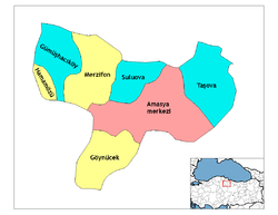 Districts of Amasya | ||||||||||||||||||||||||||
| |||||||||||||||||||||||||||
Metropolitan municipalities are bolded. | |||||||||||||||||||||||||||
This article is issued from Wikipedia. The text is licensed under Creative Commons - Attribution - Sharealike. Additional terms may apply for the media files.