Gölhisar
Gölhisar (Lakecastle) is a town and district of Burdur Province in the Mediterranean region of Turkey.
Gölhisar | |
|---|---|
 Gölhisar | |
| Coordinates: 37°08′27″N 29°30′27″E | |
| Country | |
| Province | Burdur |
| Government | |
| • Mayor | H.Kürşat Kırbıyık |
| • Kaymakam | Kemal Çeber |
| Area | |
| • District | 213.17 km2 (82.31 sq mi) |
| Elevation | 1,008 m (3,307 ft) |
| Population (2012)[2] | |
| • Urban | 14,523 |
| • District | 22,057 |
| • District density | 100/km2 (270/sq mi) |
| Post code | 15400 |
| Website | www.golhisar.bel.tr |
History
During antiquity Golhisar was site of an ancient city called Kibyra, the capital of a tetrapolis comprising Kiyra itself, Bubon, Balbura and Inuanda, which according to Herodotus were founded by the Pisidians around 1000BC, Roman ruins including a 180 meter wide theater can be still seen. In the Byzantine era the town was the seat of a Christian Bishopric.
Ibn Battuta visited the small town of Qul Hisar, noting "There is no way to reach it except by a path like a bridge constructed between the rushes and the water, and broad enough only for one horse-man."[3]
Gölhisar became a district on January 13, 1953 with the merger of Uluköy and Horzum Districts. It got its name from the fortress (fortress) built on the island in the middle of the lake, 6 km from the district.
In 2016, the population of the district was recorded as 22,485 persons.[4]
Geography
Gölhisar District is located in the Dalaman Stream Water Collection Basin at the foothills of the Western Taurus Mountains, 107 to Burdur, 111 to Denizli, 90 to Fethiye, 135 km to Antalya, southwest of Burdur. Its average altitude is 945 meters and its area is 575,820 square kilometers. The area is an important Ramsar Site.
Gölhisar Plain is a sediment plain and is irrigated by the waters of Yapraklı Dam. The district has a population of at least 15,000.
Agriculture is important to the local economy with Beets, anise, cereals, vegetables and fruits being grown. The region contains the most important music and folklore cultures of the region.
See also
References
- "Area of regions (including lakes), km²". Regional Statistics Database. Turkish Statistical Institute. 2002. Retrieved 2013-03-05.
- "Population of province/district centers and towns/villages by districts - 2012". Address Based Population Registration System (ABPRS) Database. Turkish Statistical Institute. Retrieved 2013-02-27.
- Battutah, Ibn (2002). The Travels of Ibn Battutah. London: Picador. pp. 105, 309. ISBN 9780330418799.
- https://www.webcitation.org/6Bty1Xs3f
Gölhisar in Burdur Province of Turkey | |||||||||||||||||||||||||||
|---|---|---|---|---|---|---|---|---|---|---|---|---|---|---|---|---|---|---|---|---|---|---|---|---|---|---|---|
| Districts | 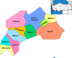 Districts of Burdur | ||||||||||||||||||||||||||
| |||||||||||||||||||||||||||
Metropolitan municipalities are bolded. | |||||||||||||||||||||||||||