QwaQwa
QwaQwa was a bantustan ("homeland") in the central eastern part of South Africa. It encompassed a very small region of 655 square kilometres (253 sq mi) in the east of the former South African province of Orange Free State, bordering Lesotho. Its capital was Phuthaditjhaba. It was the designated homeland of more than 180,000 Sesotho-speaking Basotho people.
QwaQwa | |||||||||
|---|---|---|---|---|---|---|---|---|---|
| 1974–1994 | |||||||||
.svg.png) Flag
 Coat of arms
| |||||||||
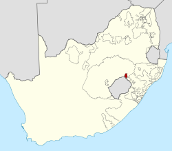 Location of QwaQwa (red) within South Africa (yellow). | |||||||||
| Status | Bantustan | ||||||||
| Capital | Phuthaditjhaba | ||||||||
| Common languages | Sesotho English Afrikaans | ||||||||
| Chief Minister | |||||||||
| History | |||||||||
• Self-government | 1 November 1974 | ||||||||
• Re-integrated into South Africa | 27 April 1994 | ||||||||
| Area | |||||||||
| 1980[1] | 620 km2 (240 sq mi) | ||||||||
| Population | |||||||||
• 1980[1] | 157,620 | ||||||||
• 1991[2] | 542,886 | ||||||||
| Currency | South African rand | ||||||||
| |||||||||
| Today part of | South Africa | ||||||||
The frequent snow on the Drakensberg mountain peaks led the San to call the region "Qwa-Qwa" (whiter than white). In Afrikaans it was known as "Witsieshoek", after Oetse (also Witsie and Wetsi), a Makholokoe chief who lived there from 1839 to 1856.[3]
Three tribes lived in the region, the Makholokoe, Bakoena and the Batlokoa. In 1969[4] they were united and the area was named "KwaKwa". In the same year, the name was changed to "QwaQwa" to avoid an ethnic identification.
History
On 1 November 1974 QwaQwa was granted self-government, with Kenneth Mopeli as Chief Minister. Mopeli would serve as Chief Minister throughout QwaQwa's existence.
After 27 April 1994 QwaQwa was dissolved, following the first South African democratic election and reunited with Orange Free State. It is now part of the Free State province, with Phuthaditjhaba serving as the seat of Maluti a Phofung Local Municipality.
The municipality also comprises the towns of Harrismith and Clarens. Together they have a combined population of 385 413, of which about 80% lives in the former QwaQwa. The population is divided as follows: 98.09% Black; White 1.68%; Coloured 0.09% and Asian and/or Indian 0.13%.
The place was also a major educational centre in the old apartheid days, with at least 80% of schools in the present Free State province having teachers that were educated in the former homeland. It has a fully functional university but its teachers' colleges have been turned into FETs (Further Education and Training) colleges. The university was called "The University of QwaQwa" before 1994 but has then been incorporated into the University of the Free State (UFS) and renamed "UFS QwaQwa Campus".
The bantustan of QwaQwa had only one district in 1991, Witsieshoek, with a population of 342,886.[2]
See also
- Chief Ministers of QwaQwa
References
- Sally Frankental; Owen Sichone (2005-01-01). South Africa's Diverse Peoples: A Reference Sourcebook. ABC-CLIO. p. 187. ISBN 978-1-57607-674-3. Retrieved 2013-09-18.
- "Census > 1991 > RSA > Variable Description > Person file > District code". Statistics South Africa - Nesstar WebView. Archived from the original on 19 June 2016. Retrieved 18 August 2013.
- Raper, PE. "Dictionary of Southern African Place Names". Human Science Research Council. p. 478. Retrieved 15 February 2016.
- Flags of the world Discussion of name and history. Retrieved 10 April 2006.
| |||||||||||||||||||||||||||||||||||||||||||||||||||||||||||||||||||||||||||||||||||||||||||||||||||||||||||