Firuzabad, Fars
Firuzabad (Persian: فيروزآباد also Romanized as Fīrūzābād; Middle Persian: Gōr or Ardashir-Khwarrah, literally "The Glory of Ardashir"; also Shahr-e Gūr شهر گور)[2] is a city and capital of Firuzabad County, Fars Province, Iran. At the 2006 census, its population was 58,210, in 12,888 families.[3] Firuzabad is located south of Shiraz. The city is surrounded by a mud wall and ditch.
Firuzabad فيروزآباد | |
|---|---|
City | |
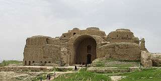 Palace of Ardeshir | |
 Firuzabad | |
| Coordinates: 28°50′38″N 52°34′15″E | |
| Country | |
| Province | Fars |
| County | Firuzabad |
| Bakhsh | Central |
| Elevation | 1,467 m (4,813 ft) |
| Population (2016 Census) | |
| • Total | 65,417 [1] |
| Time zone | UTC+3:30 (IRST) |
| • Summer (DST) | UTC+4:30 (IRDT) |
The original ancient city of Gor, dating back to the Achaemenid period, was destroyed by Alexander the Great. Centuries later, Ardashir I, the founder of the Sassanian Empire, revived the city before it was ransacked during the Arab Muslim invasion of the seventh century. It was again revived by the Buyids, but was eventually abandoned in the Qajar period and was replaced by a nearby town, which is now Firuzabad.
Climate
Firuzabad has a hot semi-arid climate (Köppen climate classification: BSh).
| Climate data for Firuzabad | |||||||||||||
|---|---|---|---|---|---|---|---|---|---|---|---|---|---|
| Month | Jan | Feb | Mar | Apr | May | Jun | Jul | Aug | Sep | Oct | Nov | Dec | Year |
| Average high °C (°F) | 13.6 (56.5) |
15.0 (59.0) |
19.3 (66.7) |
22.5 (72.5) |
29.6 (85.3) |
34.2 (93.6) |
36.7 (98.1) |
36.6 (97.9) |
33.9 (93.0) |
29.0 (84.2) |
22.4 (72.3) |
16.9 (62.4) |
25.8 (78.5) |
| Daily mean °C (°F) | 7.8 (46.0) |
9.0 (48.2) |
12.4 (54.3) |
15.6 (60.1) |
21.8 (71.2) |
26.0 (78.8) |
29.0 (84.2) |
28.8 (83.8) |
25.7 (78.3) |
20.8 (69.4) |
15.0 (59.0) |
10.7 (51.3) |
18.6 (65.4) |
| Average low °C (°F) | 2.0 (35.6) |
3.0 (37.4) |
5.6 (42.1) |
8.8 (47.8) |
14.1 (57.4) |
17.8 (64.0) |
21.4 (70.5) |
21.0 (69.8) |
17.5 (63.5) |
12.8 (55.0) |
7.7 (45.9) |
4.5 (40.1) |
11.4 (52.4) |
| Average precipitation mm (inches) | 72 (2.8) |
55 (2.2) |
35 (1.4) |
25 (1.0) |
1 (0.0) |
0 (0) |
1 (0.0) |
0 (0) |
0 (0) |
7 (0.3) |
24 (0.9) |
48 (1.9) |
268 (10.5) |
| Source: Climate-data.org | |||||||||||||
History
Gor dates back to the Achaemenid era. It was situated in a low-lying area of the region, so, during his invasion of Persia, Alexander the Great was able to drown the city by directing the flow of a river into the city. The lake he created remained until Ardashir I built a tunnel to drain it. He founded his new capital city on this site.
Ardashir's new city was known as Khor Ardashīr, Ardashīr Khurrah and Gōr. It had a circular plan so precise in measurement that the Persian historian Ibn Balkhi wrote it to be "devised using a compass". It was protected by a trench 50 meters in width, and was 2 kilometers in diameter. The city had four gates; to the north was the Hormozd Gate, to the south the Ardashir Gate, to the east the Mithra Gate and to the west the Wahram Gate. The royal capital's compounds were constructed at the center of a circle 450 m in radius. At the center of the town there was a lofty platform or tower, called Terbal. It was 30 m high and spiral in design. The design is unique in Iran, and there are several theories regarding the purpose of its construction.[4][5] It is thought to have been the architectural predecessor of the Great Mosque of Samarra of Iraq and its distinctive minaret, the malwiya.[6] In the Sasanian period, the abbreviation ART (in Inscriptional Pahlavi) was used as the mint signature to refer to Gōr.[7]
Gor and Istakhr strenuously resisted the invading Arab Muslims in the 630s and 640s; they were conquered by Abdallah ibn Amr in 649–50.[4]
The city's importance was revived again in the reign of Adud al-Dawla of the Buyid dynasty, who frequently used the city as his residence. It is at this time that the old name of the city, Gōr, was abandoned in favor of the new. In New Persian, spoken at the time, the word Gōr (گور) had come to mean "grave." King Adud al-Dawla, as the story goes, found it distasteful to reside in a "grave." Per his instruction, the city's name was changed to Peroz-abad, "City of Victory." Since then, the city has been known by variations of that name, including Firuzabad (فیروزآباد Fīrūzābād).[4] However, there is a 7th-century Arab-Sassanian coin from Ardashir-Khwarra during Umayyad period in which pylwj'b'd (Pahlavi; Pērōzābād) is mentioned as the mint.[8][9]
The city was eventually abandoned in Qajar period and its nearby settlement was populated, which is now the modern Firuzabad located 3 km to the east of the site of Gor.[9] Today, among the attractions of Firuzabad are the Sassanid Ghal'eh Dokhtar, the Palace of Ardeshir, and the fire temple and its nearby Minar.
Higher education
The city has five universities: Firuzabad Higher education university, Islamic Azad University, Firuzabad Branch; Payame Noor University, Firuzabad center; a branch of Technical and Vocational University; and a branch of University of Applied Science and Technology.[10]
See also
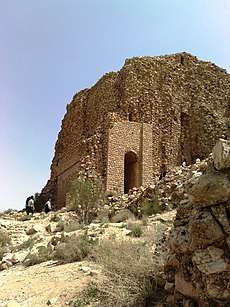
- Ghal'eh Dokhtar in Firuzabad
- Palace of Ardeshir in Firuzabad
- Bishapur
- Cities of the Ancient Near East
- Round city of Baghdad, modeled after Firuzabad and other Parthian and Sassanian round cities
References
- https://www.amar.org.ir/english
- Firuzabad, Fars can be found at GEOnet Names Server, at this link, by opening the Advanced Search box, entering "-3063026" in the "Unique Feature Id" form, and clicking on "Search Database".
- "Census of the Islamic Republic of Iran, 1385 (2006)". Islamic Republic of Iran. Archived from the original (Excel) on 2011-11-11.
- http://www.iranicaonline.org/articles/ardasir-korra
- http://www.iranicaonline.org/articles/firuzabad
- http://rch.ac.ir/article/Details?id=10224
- https://www.sasanika.org/wp-content/uploads/e-sasanika6-Miri.pdf
- http://numismatics.org/collection/1985.43.2
- "Archived copy" (PDF). Archived from the original (PDF) on 2016-04-04. Retrieved 2016-03-23.CS1 maint: archived copy as title (link)
- "Islamic Azad university of Firuzabad". Retrieved 8 April 2020.
Sources
- Bosworth, C. E. (1986). "ARDAŠĪR-ḴORRA". Encyclopaedia Iranica, Vol. II, Fasc. 4. pp. 384–385.CS1 maint: ref=harv (link)
- Daryaee, Touraj (2012). "MEHR-NARSEH". Encyclopaedia Iranica.CS1 maint: ref=harv (link)
- Huff, Dietrich (1999). "FĪRŪZĀBĀD". Encyclopaedia Iranica, Vol. IX, Fasc. 6. pp. 633–636.CS1 maint: ref=harv (link)
- Miri, Negin (2009). Historical Geography of Fars during the Sasanian Period (PDF). Sasanika. University of Sydney. pp. 1–65. Archived from the original (PDF) on 2016-04-04. Retrieved 2016-03-23.CS1 maint: ref=harv (link)
- Morony, M. (1986). "ʿARAB ii. Arab conquest of Iran". Encyclopaedia Iranica, Vol. II, Fasc. 2. pp. 203–210.CS1 maint: ref=harv (link)
- Perikhanian, A. (1983). "Iranian Society and Law". The Cambridge History of Iran: The Seleucid, Parthian, and Sasanian periods (2). Cambridge: Cambridge University Press. pp. 627–681. ISBN 978-0-521-24693-4.CS1 maint: ref=harv (link)
External links
| Wikisource has the text of the 1911 Encyclopædia Britannica article Firūzabad. |
- Ernst Herzfeld Papers, Series 5: Drawings and Maps, Records of Firuzabad Collections Search Center, S.I.R.I.S., Smithsonian Institution, Washington, D.C.
- Firuzabad, Livius.
- A guided tour of Firouzabad Palace, Ardeshir's Palace: YouTube (2 min 52 sec).
- Fars Cultural Heritage Organization
| Styles |
|  | ||||||
|---|---|---|---|---|---|---|---|---|
| Types | ||||||||
| Elements | ||||||||
| Traditional cities | ||||||||
| Theory and analysis | ||||||||
| Lists |
| |||||||

| Capital | |||||||||||||||||||||||
|---|---|---|---|---|---|---|---|---|---|---|---|---|---|---|---|---|---|---|---|---|---|---|---|
| Districts |
| ||||||||||||||||||||||