Ergani
Ergani (Ottoman Turkish: عثمانيه Osmaniye,[3] Kurdish: Erxenî[4]), formerly known as Arghni or Arghana, is a district of Diyarbakır Province of Turkey. District's area is 1489 km. Ergani District is located in the administrative as the Southeastern Anatolia Region, but as a geographical region it is located in Eastern Anatolia. The mayor is Ahmet Kaya (HDP).[5] As the District Governor was appointed Hüseyin Sayın.[6]
Ergani | |
|---|---|
 Ergani | |
| Coordinates: 38°16′09″N 39°45′42″E | |
| Country | Turkey |
| Province | Diyarbakır |
| Government | |
| • Mayor | Ahmet Kaya (HDP) |
| • Kaymakam | Hüseyin Sayın |
| Area | |
| • District | 1,467.65 km2 (566.66 sq mi) |
| Population (2012)[2] | |
| • Urban | 69,868 |
| • District | 119,167 |
| • District density | 81/km2 (210/sq mi) |
| Post code | 21950 |
| Website | www.ergani.bel.tr |
Çayönü
Near the village of Sesverenpınar, among the Hilar rocks Çayönü hill was first settled in c. 7500 BC, and was continuously inhabited until 5000 BC (but only occasionally since then). Remains have been found from the earlier habitation, one of the most important archaeological finds of its era.[7] We can see evidence of an early city from the Neolithic period, when nomadic hunter-gatherers began to settle in one place. Excavation of Çayönü, one of the largest and best-preserved sites of its kind was begun in 1963 by Istanbul University and the University of Chicago and continues today.
Climate
Ergani has a hot-summer Mediterranean climate (Köppen climate classification: Csa).
| Climate data for Ergani | |||||||||||||
|---|---|---|---|---|---|---|---|---|---|---|---|---|---|
| Month | Jan | Feb | Mar | Apr | May | Jun | Jul | Aug | Sep | Oct | Nov | Dec | Year |
| Average high °C (°F) | 5.2 (41.4) |
6.7 (44.1) |
12.3 (54.1) |
18.7 (65.7) |
25.1 (77.2) |
31.4 (88.5) |
36.6 (97.9) |
36.3 (97.3) |
31.9 (89.4) |
23.5 (74.3) |
14.7 (58.5) |
8.1 (46.6) |
20.9 (69.6) |
| Average low °C (°F) | 0.5 (32.9) |
−1.5 (29.3) |
3.0 (37.4) |
7.6 (45.7) |
12.4 (54.3) |
17.7 (63.9) |
22.4 (72.3) |
22.3 (72.1) |
17.6 (63.7) |
11.3 (52.3) |
5.3 (41.5) |
0.9 (33.6) |
10.0 (49.9) |
| Average precipitation mm (inches) | 103 (4.1) |
97 (3.8) |
104 (4.1) |
89 (3.5) |
52 (2.0) |
10 (0.4) |
2 (0.1) |
2 (0.1) |
4 (0.2) |
49 (1.9) |
77 (3.0) |
117 (4.6) |
706 (27.8) |
| Source: Climate-data.org | |||||||||||||
History
Ergani was first mentioned Arkni/Argni as it was called by the Armenians.[8] Trade has flourished between Ergani and Mesopotamia during the third millennium BC. Ergani has a rich history of being a mining region.[9] Ergani mines used to ship copper to the early settlements at Uruk of southern Iraq. The Euphrates river connected Ergani and Uruk. Vessels of the day could easily float several tons of copper downstream to Uruk in a few weeks, the transport of hundred of tons of grain back to Anatolia was challenging. Later Mesopotamian civilizations took advantage of the more favorably placed Persian Gulf mineral resources.
Connected to the north of Elazig Province Mining District, east of the Tigris in the town of Diyarbakir province, and is connected to Diyarbakir, the south is connected to the Siverek town of Urfa, Diyarbakir connected to the west is the border with Çermik and Cungus district. Height is 955 meters from the sea. The main flow of the Tigris river water, tea Straits, Camel is a gateway. district 10 km north of the river passes through the districts of the Tigris River. Kalender and 17th districts of the territory After flowing through the Tigris enters km of land. 7 km west of the Bosphorus strait Ergani tea is off the neighborhood. yolköprü, Beaded, splayed hill villages and camel through the gateway into and form a branch of the Tigris Ergani quite productive resources of the environment has. 5–6 m depth in the center of the county out of the water, such as 50-meter drilling work is found in very rich beds. Ergani's largest copper and chromium mines in front are nearby.
Transportation
Diyarbakir-Elazig road 58th kilometers east longitude and 39 50 in the county seat is in latitude 37 32 north. From the south of Haydarpasa-Kurtalan Railway District, the Diyarbakir-Elazig road passes through the center of the county.
Education
There exist 107 elementary schools, two Anatolian High Schools and one Anatolian Teacher High School. There exists also a Dicle University Vocational School in Ergani.[10]
See also
References
- "Area of regions (including lakes), km²". Regional Statistics Database. Turkish Statistical Institute. 2002. Retrieved 2013-03-05.
- "Population of province/district centers and towns/villages by districts - 2012". Address Based Population Registration System (ABPRS) Database. Turkish Statistical Institute. Retrieved 2013-02-27.
- Tahir Sezen, Osmanlı Yer Adları (Alfabetik Sırayla), T.C. Başbakanlık Devlet Arşivleri Genel Müdürlüğü, Yayın Nu 21, Ankara, p. 393.
- Avcýkýran, Dr. Adem (ed.). "Kürtçe Anamnez, Anamneza bi Kurmancî" (PDF). Tirsik. p. 55. Retrieved 17 December 2019.
- "Diyarbakır Ergani Seçim Sonuçları - 31 Mart Diyarbakır Ergani Yerel Seçim Sonuçları". secim.haberler.com (in Turkish). Retrieved 2019-11-08.
- "T.C. Ergani Kaymakamlığı". www.ergani.gov.tr. Retrieved 2019-11-08.
- "Cayönü Tepesi". www.tf.uni-kiel.de. Retrieved 2019-11-08.
- "Voices of Mesopotamia - Tours in an Ancient Land". voicesofmesopotamia.com. Retrieved 2019-11-08.
- Çiftçi, Ali (2017). The Socio-Economic Organisation of the Urartian Kingdom. Brill. p. 122. ISBN 9789004347588.
- "Ergani Vocational High School Dicle University". www.dicle.edu.tr. Retrieved 2019-11-10.
External links
- Official City Website (in Turkish)
- Ergani website
Literature
- "A Splendid Exchange" by William J Bernstein
Ergani in Diyarbakır Province of Turkey | |||||||||||||||||||||||||||
|---|---|---|---|---|---|---|---|---|---|---|---|---|---|---|---|---|---|---|---|---|---|---|---|---|---|---|---|
| Districts | 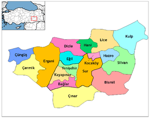 Districts of Diyarbakır | ||||||||||||||||||||||||||
| |||||||||||||||||||||||||||
Metropolitan municipalities are bolded. | |||||||||||||||||||||||||||