Eigg
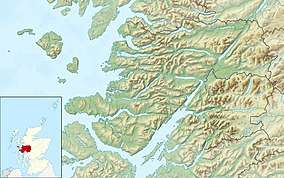
Eigg (/ɛɡ/; Scottish Gaelic: Eige) is one of the Small Isles, in the Scottish Inner Hebrides. It lies to the south of the Isle of Skye and to the north of the Ardnamurchan peninsula. Eigg is 9 kilometres (5 1⁄2 miles) long from north to south, and 5 km (3 mi) east to west. With an area of 12 sq mi (31 km2), it is the second largest of the Small Isles after Rùm. Eigg generates virtually all of its electricity using renewable energy.[5]
| Gaelic name | Eige |
|---|---|
| Pronunciation | [ˈekʲə] ( |
| Norse name | Unknown |
| Meaning of name | Scottish Gaelic for 'notched island' (eag) |
 An Sgurr | |
| Location | |
 Eigg Eigg shown within Lochaber | |
| OS grid reference | NM476868 |
| Coordinates | 56.9°N 6.15°W |
| Physical geography | |
| Island group | Small Isles |
| Area | 3,049 ha (11.8 sq mi) |
| Area rank | 28 [1] |
| Highest elevation | An Sgurr 393 m (1,289 ft) |
| Administration | |
| Sovereign state | United Kingdom |
| Country | Scotland |
| Council area | Highland |
| Demographics | |
| Population | 105[2] |
| Population rank | 47 [1] |
| Population density | 2.7 people/km2[3] |
| Largest settlement | Cleadale |
| References | [3][4] |
Geology
The larger part of the island is formed from olivine-phyric basalt flows erupted during the Palaeocene epoch. Together with flows of hawaiite and mugearite, these form the Eigg Lava Formation. The Sgurr is formed from porphyritic rhyolitic pitchstone erupted into a valley during the Eocene epoch. It displays columnar jointing formed as the lava cooled. Outcrops of an underlying conglomerate containing clasts of Torridonian sandstone and basalt are visible in places. These igneous and sedimentary rocks are collected together as the Sgurr of Eigg Pitchstone Formation.
In the north of the island are a series of sedimentary rocks of middle Jurassic and Upper Cretaceous age. The oldest of these, and hence lowest from a stratigraphic perspective is the fossiliferous Bearreraig Sandstone which is calcareous in nature. It is overlain by the Lealt Shale which consists of a lower and an upper grey shale (respectively the Kildonnan and Lonfearn members) separated by a thin band of algal limestone. The shale is overlain by the thicker Valtos Sandstone which contains concretions. It is found along the east coast northwards from Poll nam Parlan and around the northern end and down the eastern side of the Bay of Laig. This in turn is overlain by the bivalve-rich limestone and shale of the Duntulm Formation and lastly the dark shales and ostracod-bearing limestones of the Kilmaluag Formation.
These various formations are collected together as the Great Estuarine Group. The Staffin Shale which also contains siltstones, clays and limestone is found on the southwest side of Laig Bay, stratigraphically above the Great Estuarine rocks. Exposed within the Laig Gorge is the Cretaceous age Laig Gorge Limestone, the base of which is sandstone and conglomerate.
Both the igneous and the sedimentary rocks are cut through by a swarm of Palaeocene age dykes generally aligned NW-SE. A handful of faults are mapped on the same alignment, the two most significant ones stretching SE from Bay of Laig. A band of microsyenite stretches around the hillside southeast of the Sgurr.
Isolated pockets of peat of postglacial origin are to be found behind Bay of Laig whilst to its north are areas of hummocky moraine. Landslips occupy the whole coastal strip in the northeast of the island and the embayment behind Bay of Laig and effectively mask much of the outcrop of the Mesozoic sediments.[6]
Geography
| Pronunciation | ||
|---|---|---|
| Scots Gaelic: | An Laimhrig | |
| Pronunciation: | [əˈlˠ̪ajvɾʲɪkʲ] ( | |
| Scots Gaelic: | Clèadail | |
| Pronunciation: | [ˈkʰliət̪al] ( | |
| Scots Gaelic: | Eige | |
| Pronunciation: | [ˈekʲə] ( | |
| Scots Gaelic: | Uamh Fhraing | |
| Pronunciation: | [ˈuəv ˈɾaŋʲkʲ] ( | |
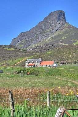
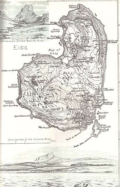
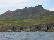
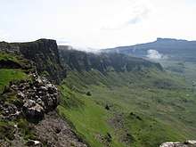
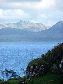
The centre of the island is a moorland plateau, rising to 393 m (1,289 ft) at An Sgurr, a dramatic stump of pitchstone, sheer on three sides. Walkers who reach the top can, in good weather, take in views of Mull, Coll, Muck, the Outer Hebrides, Rùm, Skye, and the mountains of Lochaber on the mainland.
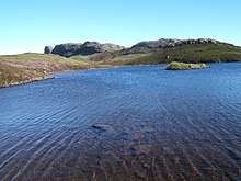
The plateau in the northern part of the island, at Beinn Buidhne, drops to a fertile coastal plain on its western side, containing Cleadale (cliff-valley), the main settlement on Eigg. At the southern end of the plain, in the centre of the island, lies the bay of Laig, known for its quartz beach, called the "singing sands" (Tràigh a' Bhìgeil) on account of the squeaking noise it makes if walked on when dry.
The plateau is cleaved by a central valley, stretching from the vicinity of Laig, in the north, to Galmisdale at its southeastern end, which forms the main port. Beyond the southeast coast lies the small islet of Eilean Chathastail.
Etymology
Adomnán calls the island Egea insula in his Vita Columbae (c. 700 AD). Other historical names have been Ega, Ego, Ege, Egge, Egg and Eige. A 2013 study suggested two origins: Gaelic eig, meaning "notch", or Norse egg or eggjar, meaning "a sharp edge on a mountain", as in Egge, Sogn og Fjordane.[8]
History
Early history
At Rubh' An Tangaird,[note 1] near the southern coast, there are the remains of an oval house, with thick walls, and an upright stone at each side of the doorway, suggestive of grandeur; comparable structures in Shetland[note 2] suggest a neolithic date.
The island also appears to have been occupied towards the end of the neolithic era, and start of the Bronze Age, as a cache of flints has been found west of Galmisdale, including a thumbnail scraper, and a barbed-and-tanged arrowhead, typical of the Beaker People has been found to the south of Kildonan.[note 3]
Later in the Bronze Age, the location of the Galmisdale cache[note 4] was used for metalworking; moulds for axes and knives typical of the period from 1000-800 BC have been discovered there,[note 5] together with significant metalworking debris.[note 6]
Iron Age

Early Iron Age hut circles are found throughout the island. One located near the North East coast contains within its bounds a cave to which walls have been artificially added; several hammerstones are located in the cave and surrounding vicinity, some with concretions of crushed shells stuck to them. The cave site is below a dramatic basalt shaft interrupting the general appearance of the cliffs, and is framed by two large boulders, one of which resembles an eagle;[note 8] archaeologists have thus concluded that the site must have been regarded as special, possibly being used for hermitic purposes[note 9] (being too remote and difficult to reach for ordinary domestic use), and have named the site the oracle cave.
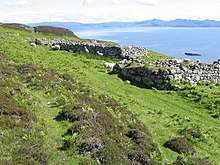
Later in the Iron Age, the inhabitants of Eigg chose to fortify the island. Small fortifications restrict access to rocky knolls,[note 10] a promontory,[note 11] and a stack;[note 12] a wall also bars access to the top of An Sgurr, a quarter of a mile west from the summit, except for a single narrow entrance.[note 13] More substantial Duns existed at Galmisdale Point,[note 14] at Upper Grulin,[note 15] and at Loch nam Ban Mora; the last of these is located on a natural island (entirely encompassed by the Dun's walls,[note 16]) which local traditions claim was once inhabited by unusually large women.[note 17]
Irish Christianity

The Irish missionary activity which brought Columba to Iona also brought Donnán to Eigg, where he attempted to establish a monastery, at Kildonnan.[note 18] According to traditional legends, a Pictish queen took objection to this breach of her sovereignty, and sent agents to Eigg to kill him,[note 19] which they did on the eve of Easter, in 617; traditionally, Donnán had a large number of companions with him,[note 20] whom he requested were killed first.[note 21] Regardless of whether accounts of Donnán's death are pious forgeries or not, the monastic community continued (or was re-populated) after Donnán's death, under the authority of Iona.
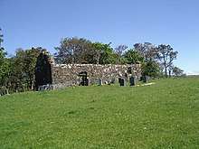
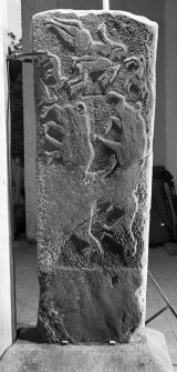
By the following century, the monastery was significant enough for the death of its superior,[note 22] Oan, to be mentioned in the Annals of Ulster. The monastery was located within an oval enclosure, surrounded by a ditch, housing a rectangular chapel in the centre, and a handful of smaller buildings either side.[note 23][10] A handful of early inscribed stone slabs were located there,[note 24] of which one bears a Pictish design, comprising a hunting scene;[note 25] the cross on its obverse is in a style which was fashionable in the 9th century.

On the coast at the opposite side of the island,[note 26] with a good view of Rùm, are 16 square cairns, lined up neatly into groups; they are each between 6 and 12 feet wide, most being bordered by a stone kerb, and some having upright corner stones. This form of cairn is usually associated with the Pictish kingdoms of Ce and Fortriu, a particularly close match being found at Garbeg,[note 27] within the latter; comparable examples date to the early 8th century. The site may have some connection with the contemporary monastery at Kildonnan.[11]
Vikings
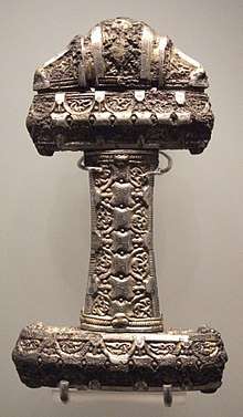
From 833, Norse settlers established the Kingdom of the Isles throughout the Hebrides. A silver/bronze sword handle from the beginning of this period was found[note 28] buried near Kildonnan,[note 29] together with an iron axehead, leather belt, buckle, wollen cloth, and a whetstone; the body to which these would once have belonged was absent. Wetlands near Laig[note 30] appear to have been used for storing partly finished boat parts, as was common in Viking Scandinavia (moist timber is easier to modify); a few oak posts, 6 feet in length, for the stern of a longship, have been found here, together with a simple bronze brooch.[note 31]
Despite being a dependency of the Norwegian king, a mid-11th century revolt by Somerled left practical authority with his heirs; the strip from Uist to the Rough Bounds, which contained the Small Isles, was ruled by the MacRory branch.[12][13][14][15][16][17] In 1266, the Treaty of Perth transferred the Kingdom of the Isles to the Scottish king, while expressly preserving the power of its local rulers; the MacRory lands became the Lordship of Garmoran, a quasi-independent crown dependency, rather than an intrinsic part of Scotland.
Clan Ranald
Early rule
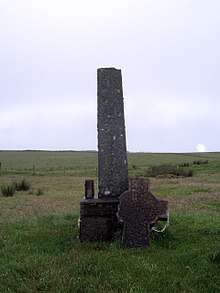
After nearly a century, the sole MacRory heir was Amy of Garmoran, who married John of Islay,[3] leader of the MacDonalds, the most powerful group among Somerled's heirs. A decade later, they divorced, and John deprived his eldest son, Ranald, of the ability to inherit the MacDonald lands; as compensation, John granted Lordship of the Uists to Ranald's younger brother Godfrey, and made Ranald Lord of the remainder of Garmoran, including Eigg.[17] At around this time, a large cross was built at Kildonnan;[note 33] local traditions report that there were a series of such crosses arranged along the island, now only indicated by placenames.[note 34]
However, when Ranald died, Godfrey seized his lands, leading to violent disputes between his heirs (the Siol Gorrie) and those of Ranald (Clan Ranald). In 1427, fed up with this behaviour, king James I arrested the leaders, and declared the Lordship of Garmoran forfeit.[18] In 1469, James' grandson (James III) granted Lairdship of the lands to mainland Garmoran John of Ross, leader of the MacDonalds. In turn, John passed it to his own half-brother, Hugh of Sleat; the grant to Hugh was confirmed by the king in a 1493 charter, but Clan Ranald continued to dispute the transfer.

Following Hugh of Sleat's death in 1498, his son, John of Sleat, resigned his position, giving his lands to the king.[note 35] John of Ross, though still living, had forfeited his own realm, which at the start of the 16th century led Black Donald to launch a rebellion, seeking to restore them. Unlike other descendants of John of Islay, Ranald Bane, leader of Clan Ranald, had refused to support the rebellion, so in 1505, once the rebellion was defeated, the king rewarded him with lairdship of Eigg (and Arisaig). In 1520, the excessive cruelty[note 36] of Ranald Bane's son, Dougall, lead to his assassination, and leadership of Clan Ranald instead passed to Ranald Bane's brother, Alexander, and then Alexander's son, John Moidartach; in 1532, the king provided a charter confirming John's position as laird of Eigg (and Arisaig).[note 37]
Writing in 1549, Donald Munro, High Dean of the Isles wrote of "Egge" that it was: "gude mayne land with ane paroch kirk in it, with mony solenne geis; very gude for store, namelie for scheip, with ane heavin for heiland Galayis".[note 38]
Massacre and pillage
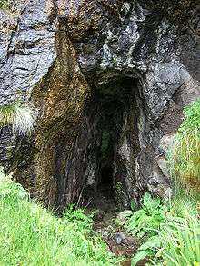
In 1577, according to Clan Ranald tradition, a group of MacLeods were being hosted on Eigg, when they became over-amorous towards local women. As a result, the local men rounded the MacLeods up, and cast them adrift in the Minch, until they were rescued by MacLeods from elsewhere. Wanting revenge, a group of MacLeods landed on Eigg, but had been spotted by the islanders, who decided to hide in an obscure cave called the Cave of Frances[note 39] (Scottish Gaelic: Uamh Fhraing) located on the south coast; the entrance to the cave is tiny,[note 40] and was obscured by moss, undergrowth, and a small waterfall.

The traditions go on to say that the MacLeods conducted a thorough but fruitless search for the inhabitants, but after 3–5 days, just as the MacLeods were leaving, they saw someone leave the cave, and were able to follow their footprints to the entrance. The MacLeods re-directed the water, piled thatch and roof timbers at the cave entrance, and set fire to it; water dampened the flames, so that the cave was filled with smoke, asphyxiating everyone inside.[note 41] 395 people had been inside;[note 42] only one inhabitant of Eigg survived, an old woman, who had not sought refuge in the cave.
Serious doubts remain about the veracity of the tale; in later times a minister of Eigg stated "the less I enquired into its history ... the more I was likely to feel I knew something about it".[21][22] Nonetheless, human remains in the cave have been reported over the centuries;[note 43][21][23] though most of the remains have since been removed and buried elsewhere,[note 44][21][23] natural disturbances in the soil occasionally uncover further remains.[note 45]
Clan Ranald had aided the MacDonalds in a longstanding feud against the MacLeans of Duart concerning the Rhinns of Islay. In 1588, some of the remains of the Spanish Armada found refuge with the MacLeans; Lachlan, the MacLean leader, demanded that they supply soldiers in return, which he used to launch an attack against the MacDonalds. After initial failures, Lachlan chose to attack the Small Isles, as a softer, weakly defended target, instead;[25] Eigg was burnt and pillaged. Lachlan was imprisoned in Edinburgh by the king for this,[note 46] but he escaped, and faced no further punishment.[note 47]
Church and reformation
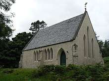
Long obliged to perform penance for his part in Dougall's assassination, John Moidartach made a vow to build a number of churches, including Kildonnan Chapel. By the time it was built, the Scottish reformation had occurred, and the Kildonnan Chapel is typical of the post-Reformation style. It was built directly on top of the site of one of the earlier monastic buildings. The fate of the original monastic chapel – which lay south of this – is unclear, but the reformation may have caused it to be abandoned and dismantled; indeed, the Kildonnan Chapel itself doesn't appear to have been finished. The statutes of Iona, in 1610, had introduced a programme of government oversight of the religious behaviour of highlands leaders; the Clan Ranald leader's consent to this had resulted in the king granting him a charter confirming his lairdship of Eigg (and his other possessions).
In 1623, however, the Irish Roman Catholic church sent Cornelius Ward,[note 48] a Franciscan friar, to North Western Scotland, in order to proselytise the population. On arriving at Castle Tioram, the seat of Clan Ranald leadership, the leader, John MacDonald, granted him protection throughout Clan Ranald lands. In 1625, Cornelius arrived on Eigg, and reported that Kildonnan Chapel was a roofless ruin; he makes no reference to events of massacre cave, and reports the island as having 200 inhabitants, all of whom he claims to have converted to Roman Catholicism. Apparently there had been a Protestant minister on the island, but John MacDonald persuaded him to turn a blind eye, by offering him the island's tithes.

Cornelius refused to consecrate the Chapel in its roofless state, and it came to only be used for burials. One grave had a carved cover with a roughly worked depiction of an occupant, sleeping; the portion below the waist and wrists is now missing, leading to the 17th/18th century grave slab[27] being popularly re-interpreted as a medieval sheela na gig.[note 49] The Chapel also contains a Clan Ranald burial recess, dated to 1641;[note 50] traditionally this is the burial place of Ranald MacDonald of Morar, a famed piper who farmed Sandavore near the end of his life,[note 51] but he was not even born until 1662.
Jacobites
As committed Roman Catholics, Clan Ranald took part in the first Jacobite rebellion, in 1689. According to Clan Ranald tradition, in May of the following year Edward Pottinger, a Royal Navy captain from Ulster, decided to take revenge for this, by inducing his men to carry out large scale rape and murder on Eigg;[28] the ship's log for Pottinger's ship, however, does not mention these events.[note 52] To evade the restrictions the government subsequently imposed on Roman Catholic services, the remaining inhabitants of Eigg began to secretly hold services in a large high-roofed cave, which became known as the cave of worship[note 53] (now Cathedral Cave).
Eigg tenants also joined the Jacobite rebellions of 1715 and of 1745; the leader of the Eigg branch of Clan Ranald – MacDonald of Laig – also commanded the tenants from Canna (another Clan Ranald property) who took part. Whether or not the events of 1690 were simply blood libel rather than gunboat diplomacy, there was certainly retribution in 1746. All 38 surviving men who had taken part in the rebellions were arrested by the navy and imprisoned in the Tower of London; though many died from natural causes, the remaining 16 were eventually sent to Barbados, to work on sugar cane plantations.
After the defeat at Culloden, the Scottish Gaelic poet Raonuill Dubh MacDhòmhnuill, the eldest son of the Jacobite officer and poet Alasdair Mac Mhaighstir Alasdair, moved from Arisaig to the farm of Laig on Eigg. The farm remained in the family until Raonuill Dubh's grandson, Angus R. MacDonald, emigrated to the United States and served as a Lieutenant in the 11th Wisconsin Regiment during the American Civil War.[29]
Crops
The 18th century introduction of the potato to Eigg, as a food crop, lead to increased health and fecundity on the island; by the end of the century, the population had expanded to over 500 people, farming oats and cattle, in addition to potatoes. The leader of Clan Ranald built a mill to grind the oats, and charged islanders to use it; since they had their own hand-querns, he instructed his agents to break them, so that the islanders had no choice but to use the mill.
The outbreak of the Napoleonic Wars created a potential new route to wealth, by limiting foreign supplies of valuable minerals: kelp could be harvested to produce minerals like soda ash. Kelp rapidly increased in price, so in 1817, the laird reduced the size of each tenancy (for example, Cleadale was re-arranged into 28 plots), to stop them being self-sufficient, thus forcing tenants to harvest kelp in order to break even. However, soon after the creation of these smaller tenancies (crofts), foreign mineral supplies were re-introduced, as the Napoleonic Wars had ended. The kelp price crashed, and crofters struggled to avoid destitution.
In 1821, several families emigrated to Nova Scotia to escape the poverty;[note 54] they settled on a high plateau near the coast of the Northumberland Strait, which they named Eigg Mountain. The laird, his income also having collapsed, planned to recover his position by evicting tenants from Cleadale, and using the land for sheep farming; however, in 1827 he found someone willing to purchase Eigg, and cancelled the planned eviction. After 800 years in the same family, Clan Ranald rule of Eigg was at an end.
Later lairds
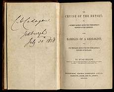
The purchaser and new owner of Eigg was one Dr. Hugh MacPherson,[note 55] and for a while island society carried on normally. The Scottish geologist and writer Hugh Miller visited the island in the 1840s and wrote a long and detailed account of his explorations in his book The Cruise of the Betsey (published in 1858). Miller was a self-taught geologist; so the book contains detailed observations of the geology of the island, including the Scuir and the singing sands. He described the islanders of Eigg as "an active, middle-sized race, with well-developed heads, acute intellects, and singularly warm feelings". He described seeing the bones of adults and children in family groups with the charred remains of their straw mattresses and small household objects still in Massacre Cave; Sir Walter Scott was so appalled and moved on hearing about this, that he started a fund for a Christian burial, which resulted in their removal.
In 1847, the financial woes of the crofters were compounded when the Highland Potato Famine struck. Dr. MacPherson decided that now was the time to evict his tenants, and replace them with sheep, the price of wool having recently undergone substantial increases.
In 1853, the whole of the village of Gruilin – fourteen families – were forced to leave Eigg; Brae was cleared in 1858. In 1862, he built Sandavore church to serve the religious needs of the remaining Church of Scotland residents. At the end of the century, in 1893, he sold the island to Lawrence Thompson, who built a church for Roman Catholic residents of the island (St. Donnan's church in Cleadale).[note 56]
After being sold by Thompson in 1917, the island passed through various hands, including a cabinet minister,[note 57] until being purchased by Keith Schellenberg.[note 58] Unlike his predecessors, who had sought to use the resources of the island for their own power, profit, or leisure, Schellenberg had conservationist motives; he wished to restore its listed buildings, and preserve the natural environment.[30]
Community buy-out
In the early 1990s, a fire at Schellenberg's home on the island destroyed a 1920s Rolls-Royce; Police suspected the fire was due to arson.[30] Some locals claimed that since the late 1980s, he had neglected homes, closed the community hall, and restricted leases.[30] While admitting that he had closed the community hall (but only in the evenings), and had refused to continue one particular lease, he told the press that "drunken hippies and drop-outs" were unfairly branding him a despot.[30] In 1994, now in his 60s, Schellenberg concluded that trying to conserve the island was not worth facing violent intimidation for,[30] and in the following year sold it to Marlin Eckhard, an artist from Germany; Schellenberg retained ownership of the 18th century Manse.

Nevertheless, by then a community trust had been formed by the Highland Council, the Scottish Wildlife Trust, and a number of residents – particularly those newly moved to the island – with a view to buying Eigg from the laird. In 1997, this Isle of Eigg Heritage Trust persuaded Eckhard to sell, and bought it from him.[31] The ceremony to mark the handover took place a few weeks after the 1997 General Election and was attended by the Scottish Office Minister, Brian Wilson, a long-standing advocate of land reform; he used the occasion to announce the formation of a Community Land Unit within Highlands and Islands Enterprise to support further land buy-outs in the region.
Between then and the 2011 census, the ordinarily resident population expanded from 65 to 83; this increase of 24 percent (six times greater than for the Scottish islands as a whole[note 59])[32] was principally formed by young people who moved to Eigg to set up in business, as well as a handful of former residents returning to the island. However, by 2003, the residents' representatives on the trust's board were entirely people who had moved to the island since the trust took over.[33]
A number of the longstanding residents complain that the trust focuses on the new residents, while ignoring the concerns of the families who have lived on the island for generations; for example, they complain that new mains power connections, and housing provision, is given to the families of trust members, not indigenous islanders.[33] One islander from an old Eigg family declared that the trust "is not a democracy ... it is the mafia".[33] More recently, more positive articles have been published, showing a different picture of the island.[34]
Eigg was featured on the American television program 60 Minutes in November 2017[35] and an extended feature on its companion web site 60 Minutes Overtime in July 2018.[36]
Economy and transport
| Caledonian MacBrayne | |||||||||||||||||||||||||||||||||||||||||||||||||||||||||||||||||||||||||||||||||||||||||||||||||||||||||||||||||||||||||||||||||||||||||||||||||||||
|---|---|---|---|---|---|---|---|---|---|---|---|---|---|---|---|---|---|---|---|---|---|---|---|---|---|---|---|---|---|---|---|---|---|---|---|---|---|---|---|---|---|---|---|---|---|---|---|---|---|---|---|---|---|---|---|---|---|---|---|---|---|---|---|---|---|---|---|---|---|---|---|---|---|---|---|---|---|---|---|---|---|---|---|---|---|---|---|---|---|---|---|---|---|---|---|---|---|---|---|---|---|---|---|---|---|---|---|---|---|---|---|---|---|---|---|---|---|---|---|---|---|---|---|---|---|---|---|---|---|---|---|---|---|---|---|---|---|---|---|---|---|---|---|---|---|---|---|---|---|
| |||||||||||||||||||||||||||||||||||||||||||||||||||||||||||||||||||||||||||||||||||||||||||||||||||||||||||||||||||||||||||||||||||||||||||||||||||||
| |||||||||||||||||||||||||||||||||||||||||||||||||||||||||||||||||||||||||||||||||||||||||||||||||||||||||||||||||||||||||||||||||||||||||||||||||||||
Tourism is important to the local economy, especially in the summer months, and the first major project of the Heritage Trust was An Laimhrig, a new building near the jetty to house the island's shop and post office, Galmisadale Bay restaurant and bar, a craft shop, and toilet and shower facilities, which are open 24 hours a day.[37] A'Nead Hand Knitwear is a new island business making garments such as cobweb shawls and scarves.[38]
There are two ferry routes to the island. There is a sheltered anchorage for boats at Galmisdale in the south of the island. In 2004 the old jetty there was extended to allow a roll-on roll-off ferry to dock. The Caledonian MacBrayne ferry MV Lochnevis sails a circular route around the four "Small Isles"—Eigg, Canna, Rùm and Muck from the fishing port of Mallaig. Arisaig Marine also runs a passenger ferry called the MV Sheerwater from April until late September from Arisaig on the mainland.[39]
A beer brewery called Laig Bay Brewing was recently set up on the island.[40][41]
Electrification project
The Heritage Trust provisioned a mains electricity grid, powered from near 100% renewable energy sources.[42] Previously, the island was not served by mains electricity and individual crofthouses had wind, hydro or diesel generators and the aim of the project is to develop an electricity supply that is environmentally and economically sustainable.
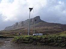
The new system incorporates a 9.9 kWp PV system, three hydro generation systems (totalling 112 kW) and a 24 kW wind farm supported by stand-by diesel generation, ultra-capacitors,[43] flywheels and batteries to guarantee continuous availability of power. A load management system has been installed to provide optimal use of the renewables. This combination of solar, wind and hydro power should provide a network that is self-sufficient and powered 98 percent from renewable sources. On 1 February 2008 the system was switched on.[44]
Eigg Electric generates a finite amount of energy and so Eigg residents agreed from the outset to cap electricity use at 5 kW at any one time for households, and 10 kW for businesses. If renewable resources are low, for example when there is less rain or wind, a "traffic light" system asks residents to keep their usage to a minimum. The traffic light reduces demand by up to 20 percent and ensures that there's always enough energy for everyone.
The Heritage Trust has formed a company, Eigg Electric Ltd, to operate the new £1.6 million network, which has been part funded by the National Lottery and the Highlands and Islands Community Energy Company.[45][46]
Other sustainability projects

In September 2008, Eigg began a year-long series of projects as part of their success as one of ten finalists in NESTA's Big Green Challenge. While the challenge finished in September 2009, the work to make the island "green" is continuing with solar water panels, alternative fuels, mass domestic insulation, transport and local food all being tackled.[47] In May 2009, the island hosted the "Giant's Footstep Family Festival", which included talks, workshops, music, theatre and advice about what individuals and communities can do to tackle climate change.[48]
In January 2010, Eigg was announced as one of three joint winners in NESTA's Big Green Challenge, winning a prize of £300,000. Eigg also won the prestigious UK Gold Award in July 2010.
Lighthouse
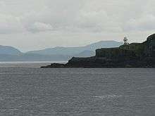 Eilean Chathastail lighthouse viewed from the Mallaig-Eigg ferry. | |

| |
| Location | Eilean Chathastail Eigg Inner Hebrides Scotland United Kingdom |
|---|---|
| Coordinates | 56.870913°N 6.121394°W |
| Year first constructed | 1906 |
| Construction | metal tower |
| Tower shape | cylindrical tower with balcony and lantern |
| Markings / pattern | white tower and lantern |
| Tower height | 8 m (26 ft) |
| Focal height | 24 m (79 ft) |
| Light source | solar power |
| Range | 8 nmi (15 km) |
| Characteristic | Fl W 6s. |
| Admiralty number | A4080 |
| NGA number | 4012 |
| ARLHS number | SCO-066 |
| Managing agent | Isle of Eigg Heritage Trust[49] |

Eigg lighthouse is an active lighthouse located on the south-eastern corner of the islet of Eilean Chathastail, one of the smaller Small Isles about 110 metres (360 ft) off Eigg. The lighthouse was built in 1906 to a design by David A. and Charles Alexander Stevenson; it is a cylindrical metal tower only 8 metres (26 ft) high with gallery and lantern painted white. It is a minor light among those owned by Northern Lighthouse Board but day-to-day management rests with the Isle of Eigg Heritage Trust. The light emits a white flash every 6 seconds.
Wildlife
An average of 130 species of birds are recorded annually. The island has breeding populations of various raptors: golden eagle, buzzard, peregrine falcon, kestrel, hen harrier and short and long-eared owl. Great northern diver and jack snipe are winter visitors, and in summer cuckoo, whinchat, whitethroat and twite breed on the island.[50][51]
See also
References
- Notes
- south of Galmisdale
- the Benie Hoose, and Stanydale temple
- now in the Edinburgh Royal Museum
- adjacent to a prominent boulder
- in 2001, during the burial of a pet cat
- the rarity of such finds, for the Bronze Age, gives the site some importance for archaeology at a national level
- The basalt shaft above oracle cave is in the background, barely visible
- hence the location's traditional name: Eagle's spur (Sron na h-Iolaire)
- though nothing is known about Iron Age religion in the region
- Garbh Bealach (in moorland, west of Galmisdale), and Poll Duchaill (on the north coast of western Eigg)
- Rudha na Crannaig ("Pulpit Point"), south of Kildonan
- Corragan Mor
- through which the modern path passes
- beyond the post-office, and bisected by the road to the former ferry terminal
- near the coast, to the west of the stream that runs past the Bothy
- some parts are still more than a yard high
- hence the name of the Loch – the Loch of the Big Women
- literally, Donnán's church
- some accounts report his assailants as pirates
- variously 51 – making it one for each week of the year, including Donnán – or 150
- some accounts say they were stabbed to death, others that they were burnt
- possibly an abbot
- excavated in 2012, under the direction of Professor John Hunter OBE, from the University of Birmingham, using Lottery funding[9]
- after excavation in 2012, they are now at the 20th century chapel of St. Donnan, in Cleadale
- the current mounting in Cleadale deliberately places this side against the wall; an old photograph of the Pictish design is located here
- near Laig
- to the north of Drumnadrochit
- in 1830
- in a field named Dail Sithean – field of the fairy hills (ie. of tumuli)
- which became peat-bog, during later centuries
- during 20th century drainage work; the finds are now in the Edinburgh Royal Museum, like the sword handle from Kildonnan
- re-erected in the 1930s, in a concrete base, having spent some time resting on the walls of the ruined chapel
- foliage on the cross matches a comparable cross from Campbelltown, dating to 1380; Ranald was nearing the end of his life at that time
- known traditional locations are, in order, Crois Moraig (Cross of Mary, at Grulin), Crois Mor (Big cross, at Kildonnan), Glac an Dorchadais (Hollow of darkness, in the middle of Eigg's central valley), and Druim na Croise (Ridge of the cross, near Howlin)
- his reasons are totally unknown
- not described in detail by surviving records
- and newly granting him Moidart – hence the name Moidartach
- English translation from Lowland Scots: "a good land with a parish church and many gannets; very good for sheep, with a good harbour for Highland galleys".[19]
- some sources translate the Gaelic Uamh Fhraing as Cave of Francis[20]
- it is no more than 0.65 metres (2.1 ft) height, requiring one to crawl for 7 metres (23 ft) before the cave opens out
- either by smoke inhalation, or oxygen deprivation
- despite external appearances, the interior of the cave is large; the length is approximately 79 metres (259 ft), the width 8 metres (26 ft) and height 6 metres (20 ft)
- for example, by Boswell in 1773, by Sir Walter Scott in 1814, and Hugh Miller in 1845
- by 1854
- as happened in 2017, when tourists discovered bones that turned out to be from a single 16 year old.[24]
- the offence was the use of Spaniards, not the violence and arson
- due to the king's status as Elizabeth I of England's heir, and Elizabeth's desire for the MacLeans to assist her against Irish rebels, wider considerations may have been at play here[26]
- In gaelic, his name is Conchobhair mac-an-Bháird
- unlike sheela na gigs, there is no haggishness to the face, and the arms are resting centralling, rather than pulling apart
- by inscription
- to whom a traditional lament is dedicated –
- Clan Ranald traditions claim he tampered with the log to cover them up[28]
- Uamh a' Chrabhaidh
- aboard the Commerce
- the price was £15,000
- in 1910
- Walter Runciman, 1st Viscount Runciman of Doxford, between 1925 and 1966 (sold by his sons, after Runciman's death in 1949)
- for a quarter of a million pounds
- which grew by only 4%, to a population of 103,702
- Citations
- Area and population ranks: there are c. 300 islands over 20 ha in extent and 93 permanently inhabited islands were listed in the 2011 census.
- "New baby helps boost Isle of Eigg's population". BBC News. 18 April 2017. Retrieved 14 February 2019.
- Haswell-Smith (2004) pp. 134–35
- Ordnance Survey. OS Maps Online (Map). 1:25,000. Leisure.
- 60 Minutes (US TV series), 26 November 2017
- "1:50000 Sheet 60 (Scotland) Rum Solid and Drift Geology". BGS mapping portal. British Geological Survey. Retrieved 8 January 2019.
- Harvie-Brown, J. A. and Buckley, T. E. (1892), A Vertebrate Fauna of Argyll and the Inner Hebrides. Pub. David Douglas., Edinburgh. Facing P. LVI.
- Broderick G., 2013, Some Island Names in the Former 'Kingdom of the Isles': A Reappraisal. The Journal of Scottish Name Studies 7:1-28.
- Monastery where Christian saint was martyred is uncovered on Eigg, Alistair Munro, The Scotsman, 14 August 2012
- John Hunter, Excavations at Kildonnan, Eigg, 2012, University of Birmingham
- RCAHMS Archaeological Field Survey: Eigg, NM48NE 12
- Kingship and Unity, Scotland 1000–1306, G. W. S. Barrow, Edinburgh University Press, 1981
- Galloglas: Hebridean and West Highland Mercenary Warrior Kindreds in Medieval Ireland, John Marsden, 2003
- Lismore: The Great Garden, Robert Hay, 2009, Birlinn Ltd
- Proceedings of the Society of Antiquaries of Scotland, 90 (1956–1957), A.A.M. Duncan, A.L Brown, pages 204-205
- The Kingdom of the Isles: Scotland's Western Seaboard, R. A. McDonald, 1997, Tuckwell Press
- Rixson (2001) page 93.
- Gregory, Donald (1836), History of the Western Highlands and Isles of Scotland, from A.D. 1493 to A.D. 1625, with a brief introductory sketch, from A.D. 80 to A.D. 1493, Edinburgh, W. Tait, retrieved 11 May 2012, p. 65
- Munro, D. (1818) Description of the Western Isles of Scotland called Hybrides, by Mr. Donald Munro, High Dean of the Isles, who travelled through most of them in the year 1549. Miscellanea Scotica, 2. Quoted in Banks (1977) p. 190
- Some sources translate the Gaelic Uamh Fhraing as the Cave of Francis. (Macpherson, Norman. Notes on antiquities from the island of Eigg, Edinburgh University.) Archived 11 June 2007 at the Wayback Machine
- Banks (1977) pp. 56–67
- Kieran, Ben. Blood and Soil: A World History of Genocide and Extermination from Sparta to Darfur, Yale University Press, 2007 ISBN 0-300-10098-1, ISBN 978-0-300-10098-3. p. 14
- Lynn Forest-Hill, "Underground Man", Times Literary Supplement 14 January 2011 p. 15
- Urbanus, Jason (July–August 2017). "A dangerous island". Archaeology. 70 (4): 14. ISSN 0003-8113. Retrieved 2 July 2017 – via EBSCO's Master File Complete (subscription required)
- Maureen Meikle, The Scottish People 1490–1625, Lulu.com, 2013, p. 146
- John Lorne Campbell, Canna: The Story of a Hebridean Island, 2014, Birlinn Ltd
- Ruined Church at Kildonnan, Canmore (Royal Commission on the Ancient and Historical Monuments of Scotland)
- Allan I. MacInnes, Clan Massacres and British State Formation, in The Massacre in History, edited by Mark Levene / Penny Roberts, Berghahn Books, 1999
- Father Charles MacDonald (2011), Moidart: Among the Clanranalds, Birlinn Books. Pages 133-137.
- Eigg owner says violent campaign has made him sell, John Arlidge, 28 January 1994, The Independent
- Alastair McIntosh (2001). Soil and Soul: People Versus Corporate Power. Aurum Press Ltd. ISBN 978-1854108029.
- "Scotland's 2011 census: Island living on the rise". BBC News. 15 August 2013. Retrieved 18 August 2013.
- Scrambled Dreams on Eigg, Kirsty Scott, 4 August 2003, The Guardian
- Patrick Barkham (26 September 2017). "This island is not for sale: how Eigg fought back". The Guardian. Retrieved 14 February 2019.
- Kroft, Steve (26 November 2017). "The Isle of Eigg". CBS News.
- Kroft, Steve (24 June 2018). "60 Minutes' adventure to the Isle of Eigg". CBS News.
- "Eigg Shop and Post Office" Archived 2009-06-05 at the Wayback Machine Isle of Eigg Heritage Trust. Retrieved 1 August 2009.
- "A'Nead Hand Knitwear" anead-knitwear.co.uk. Retrieved 1 August 2009.
- "Welcome to Arisaig Marine Ltd" arisaig.co.uk Retrieved 1 August 2009.
- "A newborn baby pushes a tiny, fascinating Scottish island's population to 105 (we think)". TheJournal.ie. 23 April 2017. Retrieved 14 February 2019.
- "Laig Bay Brewing". Retrieved 14 February 2019.
- "Eigg Electric". Friends of the Earth Scotland. Retrieved 14 February 2019.
- Annie Smith (13 November 2018). "Eigg Toasts New Ultracapacitor System and Unscrambles the Power Grid". Ochaye6dot5. Retrieved 7 February 2019.
- Ross, John (31 January 2008). "Island finally turns on to green mains Eigg-tricity". The Scotsman. Retrieved 2 January 2015.
- "Isle of Eigg, Inner Hebrides, Scotland - 2007" Wind and Sun Ltd. Retrieved 20 September 2007. Archived 1 December 2007 at the Wayback Machine
- "Island energised by lottery cash". BBC News. 16 November 2005. Retrieved 20 September 2007.
- "Green Eigg islanders earn place in UK's Big Challenge says Press and Journal" islandsgoinggreen.org. Retrieved 23 September 2009.
- "Take Giant Green Footsteps to Eigg's Family Festival" Archived 24 July 2011 at the Wayback Machine. Senscot. Retrieved 23 September 2009.
- Eigg The Lighthouse Directory. University of North Carolina at Chapel Hill. Retrieved 22 May 2016
- "Eigg-ceptional summer". Scottish Wildlife (November 2007) No. 63 page 4.
- "Bird watching on Eigg" Archived 2009-02-23 at the Wayback Machine Isle of Eigg Heritage Trust. Retrieved 27 December 2007.
- General references
- Banks, Noel, (1977) Six Inner Hebrides. Newton Abbott: David & Charles. ISBN 0-7153-7368-4
- Haswell-Smith, Hamish (2004). The Scottish Islands. Edinburgh: Canongate. ISBN 978-1-84195-454-7.
- Barkham, Patrick (26 September 2017). "This island is not for sale: how Eigg fought back". The Guardian. Retrieved 26 September 2017.
External links
| Wikivoyage has a travel guide for Eigg. |
| Wikimedia Commons has media related to Eigg. |
- The island's website
- Geology of Eigg
- BBC Radio 4 – Open Country
- BBC Action Network - My story: Bringing power to the people
- Ashden Awards Case Study, video and photographs
- Book about the role of incomers on the island and photogallery
- The Cruise of the Betsey- Account of Miller's voyage.

Inhabited islands of the Hebrides | ||
|---|---|---|
| Inner Hebrides |  | |
| Outer Hebrides | ||
|  | ||||||||||||||||
|
| |||||||||||||||||
| |||||||||||||||||
| |||||||||||||||||
| |||||||||||||||||
| |||||||||||||||||
| |||||||||||||||||
| |||||||||||||||||