North Uist
North Uist (Scottish Gaelic: Uibhist a Tuath) is an island and community in the Outer Hebrides of Scotland.
| Gaelic name | Uibhist a Tuath |
|---|---|
| Pronunciation | [ˈɯ.ɪʃtʲ ə ˈt̪ʰuə] ( |
| Meaning of name | North Uist (etymology of "Uibhist" is unclear) |
 | |
| Location | |
 North Uist North Uist shown within the Outer Hebrides | |
| OS grid reference | NF835697 |
| Coordinates | 57.6°N 7.333°W |
| Physical geography | |
| Island group | Uist and Barra |
| Area | 30,305 ha (74,885 acres) |
| Area rank | 10 [1] |
| Highest elevation | Eaval 1,138 ft (347 m) |
| Administration | |
| Sovereign state | United Kingdom |
| Country | Scotland |
| Council area | Comhairle nan Eilean Siar |
| Demographics | |
| Population | 1,254[2] |
| Population rank | 12 [1] |
| Population density | 4.14 people/km2[2][3] |
| Largest settlement | Lochmaddy |
| References | [3][4][5][6] |
| Official name | North Uist Machair and Islands |
| Designated | 22 July 1997 |
| Reference no. | 1004[7] |
Etymology
In Donald Munro's A Description of the Western Isles of Scotland Called Hybrides of 1549, North Uist, Benbecula and South Uist are described as one island of Ywst (Uist). Starting in the south of this 'island', he described the division between South Uist and Benbecula where "the end heirof the sea enters, and cuts the countrey be ebbing and flowing through it". Further north of Benbecula he described North Uist as "this countrey is called Kenehnache of Ywst, that is in Englishe, the north head of Ywst".[8]
Some have taken the etymology of Uist from Old Norse, meaning "west",[3] much like Westray in Orkney.[9] Another speculated derivation of Uist from Old Norse is Ívist,[5] derived from vist meaning "an abode, dwelling, domicile".[10]
A Gaelic etymology is also possible, with I-fheirste meaning "Crossings-island" or "Fords-island", derived from I meaning "island" and fearsad meaning "estuary, sand-bank, passage across at ebb-tide".[9][11] Place-names derived from fearsad include Fersit, and Belfast.[11] Mac an Tàilleir (2003) suggests that a Gaelic derivation of Uist may be "corn island".[12] However, whilst noting that the -vist ending would have been familiar to speakers of Old Norse as meaning "dwelling", Gammeltoft (2007) says the word is "of non-Gaelic origin" and that it reveals itself as one of a number of "foreign place-names having undergone adaptation in Old Norse".[13] In contrast, Clancy (2018) has argued that Ívist itself is an Old Norse calque on an earlier Gaelic name, *Ibuid or Ibdaig, which corrisponds to Ptolemy’s Eboudai.[14]
History
Early history
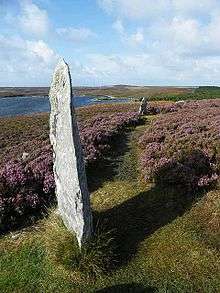
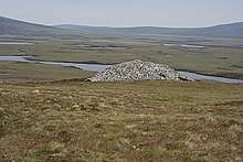
A number of standing stones from the Neolithic period are scattered throughout the island, including a stone circle at Pobull Fhinn. In addition to these, a large burial cairn, in almost pristine condition, is located at Barpa Langass. The island remained inhabited for at least part of the Bronze Age; a burial from this period was found on the Udal peninsula (near Sollas). For the Iron Age, in addition to the wheelhousess typical of the Outer Hebrides, the remains of a broch, from the late Iron Age, can be found at Dun an Sticir; there was formerly another broch near Scolpaig, but it was replaced by Scolpaig Tower in the 19th century. In the 3rd century, stone houses came into use which were shaped like "Jelly Babies"[note 1].
Kingdom of the Isles
Whoever the occupants of Jelly Baby houses were, they were followed in the 9th century by Viking settlers, who established the Kingdom of the Isles throughout the Hebrides. Initially, vikings built turf-based buildings; however, on the shore, the environmental and chemical composition of machair causes these buildings to rapidly degrade and turn mauve[note 2]. Following Norwegian unification, the Kingdom of the Isles became a crown dependency of the Norwegian king; to the Norwegians it was Suðreyjar (meaning southern isles). Malcolm III of Scotland acknowledged in writing that Suðreyjar was not Scottish, and king Edgar quitclaimed any residual doubts.
However, in the mid-12th century, Somerled, a Norse-Gael of uncertain origin, launched a coup, which made Suðreyjar entirely independent. Following his death, Norwegian authority was nominally restored, but in practice, the kingdom was divided between Somerled's heirs (Clann Somhairle), and the dynasty that Somerled had deposed (the Crovan dynasty). The MacRory, a branch of Somerled's heirs, ruled Uist, as well as Barra, Eigg, Rùm, the Rough Bounds, Bute, Arran, and northern Jura.[15][16][17][18][19]
In the 13th century, despite Edgar's quitclaim, Scottish forces attempted to conquer parts of Suðreyjar, culminating in the indecisive Battle of Largs.
In 1266, the matter was settled by the Treaty of Perth, which transferred the whole of Suðreyjar to Scotland, in exchange for a very large sum of money[note 3]. The Treaty expressly preserved the status of the rulers of Suðreyjar; the MacRory lands, excepting Bute, Arran, and Jura, became the Lordship of Garmoran, a quasi-independent crown dependency, rather than an intrinsic part of Scotland.
Lordship of Garmoran

At the turn of the century, William I had created the position of Sheriff of Inverness, to be responsible for the Scottish highlands, which theoretically now extended to Garmoran.[20][21] In 1293, however, King John Balliol established the Sheriffdom of Skye, which included the Outer Hebrides. Nevertheless, following his usurpation, the Skye sheriffdom ceased to be mentioned[note 4], and the Garmoran lordship (including Uist) was confirmed to the MacRory leader. In 1343, King David II issued a further charter for this to the latter's son.[22]
Just three years later[note 5] the sole surviving MacRory heir was Amy of Garmoran. The southern parts of the Kingdom of the Isles had become the Lordship of the Isles, ruled by the MacDonalds (another group of Somerled's descendants). Amy married the MacDonald leader, John of Islay, but a decade later he divorced her, and married the king's niece instead (in return for a substantial dowry). As part of the divorce, John deprived his eldest son, Ranald, of the ability to inherit the Lordship of the Isles, in favour of a son by his new wife. As compensation, John granted Lordship of the Uists to Ranald's younger brother Godfrey, and made Ranald Lord of the remainder of Garmoran.
However, on Ranald's death, his sons were still children, and Godfrey took the opportunity to seize the Lordship of Garmoran. Furthermore, Godfrey had a younger brother, Murdoch, whose heirs (the Siol Murdoch) now claimed to own part of North Uist. This led to a great deal of violent conflict involving Godfrey's family (the Siol Gorrie) and those of his brothers. Surviving records do not describe this in detail, but traditional accounts report an incident where the Siol Gorrie dug away the embankment of a Loch, causing it to flood a nearby village in which the Siol Murdoch lived (and hence drown them); the accounts claim that the floodwater formed Loch Hosta.[23]
In 1427, frustrated with the level of violence generally in the highlands, together with the insurrection caused by his own cousin, King James I demanded that highland magnates should attend a meeting at Inverness. On arrival, many of the leaders were seized and imprisoned. Alexander MacGorrie, son of Godfrey, was considered to be one of the two most reprehensible, and after a quick showtrial, was immediately executed.[24] As Alexander had by now inherited Godfrey's de facto position as Lord of Garmoran, and in view of Ranald's heirs being no less responsible for the violence, King James declared the Lordship forfeit.
Early lairds
Hugh of Sleat and his sons

Following the forfeiture, most of Garmoran (including North Uist) remained with the Scottish crown until 1469, when James III granted Lairdship of it to John of Ross, the Lord of the Isles. In turn, John passed it to his own half-brother, Hugh of Sleat; the grant to Hugh was confirmed by the king - James IV - in a 1493 charter, but Ranald's heirs (Clan Ranald) disputed the charter.
Hugh died a few years later, and in 1505 his eldest son, John, granted North Uist (and Sleat) to Ranald Bane, the Captain of Clanranald; the reasons John had for this are not reported by surviving records. Nevertheless, Hugh's second son, Donald Gallach, opposed Clan Ranald and established his own de facto control of North Uist and Sleat[note 6]. In the following year (1506), Donald was stabbed to death by his own younger brother - Black Archibald. The king authorised Ranald Bane to take the lands by force; according to traditional accounts, Ranald Bane's success led to Black Archibald resorting to piracy.[25]
Three years later, however, Black Archibald returned. Traditional accounts relate that while he had been away, Angus Collach[note 7] (Archibald's other brother) attempted to rape a woman on North Uist; outraged by this, an armed party made up of men from the Siol Gorrie (to which the woman belonged) and Clan Ranald (to which her husband belonged) captured Angus and drowned him at sea.[25] According to these accounts, Black Archibald now took revenge, killing large numbers of Siol Gorrie.[25] Despite his behaviour, Black Archibald managed to ingratiate himself with James IV, by capturing and handing over two pirates - distant relations from Clan MacAlister;[25] in 1511, the king rewarded Black Archibald by pardoning him for his crimes, and confirming his possession of Sleat and North Uist.[25]
The Hunchback
At some point before 1520, Black Archibald was murdered by Donald Gallach's son, Donald Gruamach[note 8]. Consequently, in 1520, James IV issued a charter awarding lairdship of Sleat and North Uist to Alastair Crotach MacLeod[note 9], the leader of the Sìol Tormoid, who possessed the neighbouring lands, and had been loyal to James during Donald Dubh's rebellion.
In 1539, Donald Gruamach's son - Donald Gorm[note 10] - invaded the Siol Tormoid lands on Skye, in an attempt to take back Sleat and North Uist[note 11]. However, that same year, Donald Gorm was hit by an arrow while besieging Eilean Donan castle; in the process of removing it, he severed an artery, and died[note 12]. In 1542, king James V issued a charter confirming Alastair Crotach as laird of Sleat and North Uist.
Mary MacLeod
After the deaths of Alastair Crotach and his son William, in quick succession (1547, and 1553, respectively), Alastair's heir was his young granddaughter, Mary MacLeod. Donald Gormson, Donald Gorm's son, took the opportunity to seize Sleat and North Uist. The Regent assigned nominal feudal wardship of her to the Earl of Huntly, who himself proposed to sell it to the Earl of Argyll. In 1554, the following year, Mary of Guise became Regent (for her daughter, Mary, Queen of Scots), and issued both Earls with Letters of Fire and Sword against Donald Gormson, and Clan Ranald, instructing the Earls to pursue their utter extermination.
However, the forces of the Earl of Huntly had previously been defeated by Clan Ranald at the Battle of the Shirts, which made them reluctant to enter Clan Ranald territory; the Earl abandoned the pursuit, but was promptly imprisoned by Mary of Guise for doing so. Three years later, the Lords of the Congregation, the Earl of Argyll among them, emerged as an organised resistance to Mary of Guise. By 1562, the Earl of Huntly, now released, was in outright opposition to Queen Mary, and died opposing her at the Battle of Corrichel. Three years later, Donald Gormson had taken the Queen's side during the Chaseabout Raid, and was consequently back in royal favour; the tables had turned completely.
Consequently, on 4 March 1567[note 13] Donald Gormson and the Earl of Argyll drew up a contract, according to which:
- Donald Gormson would enter a bond of manrent to the Earl of Argyll
- Donald Gormson would provide military aid to Mary MacLeod's uncle, on demand from the Earl of Argyll
- Mary MacLeod would quitclaim her rights to Sleat and North Uist in return for 500 marks, to be paid by Donald Gormson
- The Earl of Argyll would persuade the Queen to grant him a charter for those lands, and subinfeudate them to Donald Gormson, in return for 1000 marks
Old Blue-eyes

In 1594, as an opponent of The Reformation, Donald Gorm Mor - Donald Gormson's grandson[note 14] - sent troops to support Tyrone's rebellion against the Queen Elizabeth of England. In 1596, concerned by this, and similar action by other highland leaders, King James VI of Scotland (Elizabeth's heir) demanded that highland leaders send well-armed men, as well as attending themselves, to meet him at Dumbarton on 1 August. Donald Gorm Mor obeyed the summons, and was consequently pardoned for previous offences, and granted a charter which acknowledged him as rightful heir of Hugh of Sleat, and confirmed him as laird of Sleat and North Uist.
In an attempt to solidify peaceful relations with the Siol Tormoid, Donald Gorm Mor married the daughter of the then Siol Tormoid leader, Rory. Unfortunately, the marriage failed catastrophically, leading to the War of the One-Eyed Woman. A series of initial skirmishes led to the Battle of Carinish in North Uist, the last battle in Scotland that involved bows and arrows. Though the Donald the Battle, it led to the Battle of Coire Na Creiche, where he won a more decisive victory, at which point the privy council intervened, and imposed a lasting peace. Donald was succeeded by his nephew, Donald Gorm Og[note 15], whose loyalty to the king resulted in him being made the first Baronet of Sleat[note 16].
Post-union
The Papists Act
A century later, Donald Gorm Og's heir, the 4th Baronet of Sleat[note 17], was living comfortably in Glasgow. However, in 1715, he decided to support the Jacobite rebellion, and attacked the Earl of Sutherland, but fell ill and fled to Skye; he was pursued, and forced to flee to North Uist.[27] When the Papists Act was passed the following year, requiring his attendance at Inverlochy, he argued that he was too ill to travel, but magistrates could visit him instead. Under the terms of the act, this made him a recusant,[27] and his lairdships were accordingly forfeited, under the terms of the Forfeited Estates Act of the previous year.[27]
The Commissioners of Forfeited Estates surveyed the land, and found that it was in very poor condition; in North Uist, the local population had recently lost 745 cows, 573 horses, and 820 sheep, to plague, and the sea had overflowed the land and destroyed many houses.[27] On his succession, in 1723, the 7th baronet[note 18] arranged for a middleman, Kenneth MacKenzie[note 19], to buy back Sleat and North Uist from the Commissioners[note 20], and pass them on to him.[27] In 1727, the 7th baronet was granted a royal charter, formally acknowledging his position as laird of the Sleat and North Uist.[27]
According to historian John Lorne Campbell, Sir Alexander MacDonald of Sleat and his Clan took no part in the Jacobite Uprising of 1745, but they were included in the repression of Highland dress and culture that followed the Battle of Culloden. However, North Uist Bard Iain Mac Fhearchair, the official poet to the Chief, wrote a satirical poem entitled, Oran an Aghaidh an Eididh Ghallda ("A Song Against the Lowland Garb"), which "shows clearly where his own sympathies lay."[28]
Kelp
During the French Revolutionary Wars, the scarcity of external supplies of minerals to the United Kingdom led to a boom in the kelp industry, which became North Uist's main source of income.[29] When the war ended, the sudden re-availability of foreign mineral supplies led to an abrupt collapse in the demand for kelp-based products. The burning of kelp had also damaged the fertility of the land. As a result, the crofters of North Uist could no longer afford the rents;[29] even though the landlords reduced the rents (e.g. in 1827 the rents were reduced by 20%) many crofters resorted to emigration.[29]
In 1826 the villages of Kyles Berneray, Baile Mhic Phail and Baile mhic Conon, at the north-east corner of North Uist, were abandoned by their inhabitants. Although some moved further south-east to Loch Portain, most of those affected moved to Cape Breton, in Nova Scotia[note 21].[29] As the economic conditions worsened and with reports of islanders having success overseas, the numbers of families emigrating from Scotland to North America greatly increased.[29] By 1838, the number of people having left North Uist was reported as 1,300; before the 1820s, the population of North Uist had been almost 5,000,[30] but by 1841 it had fallen to 3,870.
The Highland Clearances
The 7th baronet's heir, Godfrey MacDonald[note 22] (the 4th Baron of Slate[note 23]) had replaced the emigrants with sheep.[31] Having turned a massive profit from this, he chose to preside over one of the most notable mass evictions of the Highland Clearances.[32] In 1849, he attempted to evict 603 crofters from Sollas[note 24], rioting broke out and women being evicted apparently even threw rocks at the police officers[note 25] who had been sent to quell the riot.[35][36] While the rioters were convicted[note 26], the jury added the following written comments:
...the jury unanimously recommend the pannels to the utmost leniency and mercy of the Court, in consideration of the cruel, though it may be legal, proceedings adopted in ejecting the whole people of Solas from their houses and crops without the prospect of shelter, or a footing in their fatherland, or even the means of expatriating them to a foreign one...[37]
Six years later[note 27], Sir Godfrey decided to sell North Uist. The buyer and new Anglo-Scottish landlord of the island was Sir John Powlett Orde.[30]
According to Bill Lawson, "The MacDonalds of Sleat possessed the island from 1469 until 1855, though the later proprietors took little interest in their estate except as a source of income. In 1855 the Lord MacDonald of the day sold the island to Sir John Powlett Orde, who had gained the reputation of being the worst type of landlord, utterly opposed to any attempt to improve the lot of his tenants, though it is only fair to point out that every one of the major evictions on the island was in fact carried out by the MacDonalds; they, being of a local source, are forgiven, and the blame is reserved for the incoming Sir John. He, in turn, sold parts of the island to his son Sir Arthur Campbell-Orde, mainly in order to frustrate the terms of the Crofter's Acts, which could have allowed crofters to apply for more land, but only on land with the same ownership. Sir Arthur eventually inherited the whole estate; he seems to have been a very different type of landlord, and was involved in the re-crofting of Sollas and other areas."[38]
Modern times
In 1889, counties were formally created in Scotland, on shrieval boundaries, by a dedicated Local Government Act; North Uist, therefore, became part of the new county of Inverness. Following late 20th century reforms, it became part of the Highland Region.
In 1944, the Campbell-Orde family sold North Uist to Douglas Douglas-Hamilton, 14th Duke of Hamilton, who sold it in turn to Granville James Leveson-Gower, 5th Earl Granville in 1960.[39] The Granville family administers the island through a trust fund called the North Uist Trust.[30]
Some of the machair townships, however, were taken over by the Board of Agriculture and its successors.[39]
The population of North Uist has now further dwindled to about 1,300. Families particularly depleted during the clearances were the MacAulays, Morrisons, MacCodrums, MacCuishs, and MacDonalds.[29]
Geology
In common with the rest of the Western Isles, North Uist is formed from the oldest rocks in Britain, the Lewisian gneiss which dates from the Archaean eon. A zone running west from Lochmaddy to Baleshare has abundant metasediments and metavolcanics. The direction of inclination of layered textures or foliation in this metamorphic rock is typically to the north but varies widely across the island. Pockets of metabasic rocks equivalent to the Scourie dyke suite are developed in certain areas, particularly in the north. Banded metabasic rocks and Archaean granites are found in the northwest around Loch Phaibeil. A band of pseudotachylyte curves north the northwest through the centre of the island.[40] The island is traversed by numerous normal faults many of which run broadly NW-SE though ranging from E-W to NNW-SSE. Loch Eport is developed along one such fault. The Outer Hebrides Thrust Zone runs along the eastern coast of the island and brings distinctive gneisses which form the rough hilly terrain along that coast. More recent geological deposits include blown sand along the northern and western coasts and peat inland.[41]
Geography
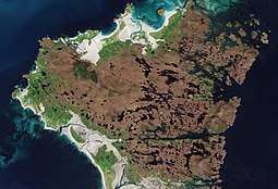
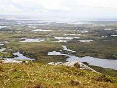
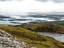
North Uist is the tenth-largest Scottish island[42] and the thirteenth-largest island surrounding Great Britain.[43] It has an area of 117 square miles (303 square kilometres),[3] slightly smaller than South Uist. North Uist is connected by causeways to Benbecula via Grimsay, to Berneray, and to Baleshare. With the exception of the south east, the island is very flat, and covered with a patchwork of peat bogs, low hills and lochans, with more than half the land being covered by water. Some of the lochs contain a mixture of fresh and tidal salt water, giving rise to some complex and unusual habitats. Loch Sgadabhagh, about which it has been said "there is probably no other loch in Britain which approaches Loch Scadavay in irregularity and complexity of outline", is the largest loch by area on North Uist although Loch Obisary has about twice the volume of water.[44] The northern part of the island is part of the South Lewis, Harris and North Uist National Scenic Area, one of 40 in Scotland.[45]
Settlements
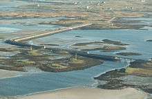
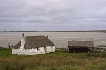
The main settlement on the island is Lochmaddy, a fishing port and home to a museum, an arts centre and a camera obscura. Caledonian MacBrayne ferries sail from the village to Uig on Skye, as well as from the island of Berneray (which is connected to North Uist by road causeway), to Leverburgh in Harris. Lochmaddy also has Taigh Chearsabhagh — a museum and arts centre with a cafe, small shop and post office service. Nearby is the Uist Outdoor Centre.
The island's main villages are Sollas, Hosta, Tigharry, Hougharry, Paible, Grimsay and Cladach Kirkibost. Other settlements include Clachan, Carinish, Knockquien, Port nan Long, Greinetobht and Scolpaig, home to the nineteenth century Scolpaig Tower folly. Loch Portain is a small hamlet on the east coast — some 9 mi (14 km) from Lochmaddy, with sub areas of Cheesebay and Hoebeg.
According to the 2011 census North Uist had a population of 1,254.
Places of interest
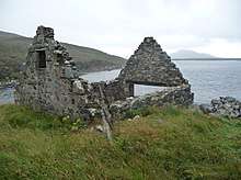
North Uist has many prehistoric structures, including the Barpa Langass chambered cairn, the Pobull Fhinn stone circle, the Fir Bhreige standing stones, the islet of Eilean Dòmhnuill (which may be the earliest crannog site in Scotland),[46] and the Baile Sear roundhouses, which were exposed by storms in January 2005.[47]
The Vikings arrived in the Hebrides in AD 800 and developed large settlements.
The island is known for its bird life, including corncrakes, Arctic terns, gannets, corn buntings and Manx shearwaters. The RSPB has a nature reserve at Balranald.[48]
Population
In the 18th century, the total population of the combined Uists rose dramatically, before the population crash of the Highland Clearances. In 1755, the Uists' estimated combined population was 4,118; by 1794 it rose to 6,668; and in 1821 to 11,009.[3]
The pre-clearance population of North Uist was about 5,000 and it has dwindled to about 1,300 in 2011.
| pre 1820s[30] | 1841 | 1881 | 1891 | 1931 | 1961 | 1971 | 1981 | 1991 | 2001[49] | 2011[2] |
|---|---|---|---|---|---|---|---|---|---|---|
| about 5,000 | 3,870 | 3,398 | 3,250 | 2,349 | 1,622 | 1,469 | 1,454 | 1,404 | 1,271 | 1,254 |
From Haswell-Smith (2004)[3] except as stated.
Gaelic
According to the 2011 Census, there are 887 Gaelic speakers (61%) on North Uist.[50]
Literature
- The False Men by Mhairead MacLeod, author. The novel is set in North Uist during the era of the Highland Clearances when the townships around Sollas were forcibly evicted resulting in "The Battle of Sollas".[51]
Notable residents
- Iain Mac Fhearchair (alias John MacCodrum) (1693-–1779)[52] was a Scottish Gaelic poet who spent his life as the "family Bard to Sir James MacDonald of Sleat."[53] One of his most popular songs is Smeòrach Chlann Dòmhnaill ("The Mavis of Clan Donald"), in which the Bard, according to Bill Lawson, "praises the isle of his birth."[54] The song was recorded by fellow North Uist native Julie Fowlis on her 2014 album Gach sgeul - Every story.
- The Scottish Gaelic war poet Dòmhnall Ruadh Chorùna (1887–1967) was born on North Uist and lived his life there. Due to his vivid descriptions of his experiences in the First World War, he is often referred to as "The Voice of the Trenches."
- Erskine Beveridge, LL.D., FRSE (1851–1920), a textile manufacturer and antiquary and sometime resident of Vallay, completed important archaeological excavations in the Hebrides.
- Julie Fowlis (born 1979), a singer and instrumentalist who sings primarily in Scottish Gaelic, was born and raised on North Uist.
- Alasdair Morrison (born 1968), former Member of the Scottish Parliament for the Western Isles, lived on North Uist and was educated at Paible School.
- Flight Lieutenant John Morrison, 2nd Viscount Dunrossil, CMG, JP (1926–2000), diplomat and Governor of Bermuda, lived at Clachan Sands.
- Pauline Prior-Pitt, a British poet, lives on North Uist.
- Brothers Rory and Calum MacDonald, members of the Gaelic rock band Runrig.
- Angus MacAskill, (1825 –1863), "true giant" and strong man from Berneray, off North Uist.
- Donald Macdonald (1825–1901), a founding minister of the Free Presbyterian Church of Scotland was born at Langass on North Uist.
- Brothers Angus Matheson (1912–1962), inaugural Professor of Celtic at the University of Glasgow, and William Matheson (1910-1995), a Scottish Gaelic scholar, academic, and ordained minister of the Church of Scotland.[55]
See also
Notes
- The first Jelly Baby House to be discovered was on the Udal peninsula.
- The distinctive purple colouring of their remains forms a useful marker for archaeologists
- 4000 marks
- in surviving records, at least
- 1346
- Historic records refer to this as holding the lands by the sword
- Collach refers to the fact that Angus' mother was from Coll
- Graumach is gaelic for gloomy
- Crotach means hunchback
- Gorm is Gaelic for turquoise; typically, Gorm was used as a nickname for people with blue/green eyes
- Donald Gorm's ultimate aim was to re-establish the Lordship of the Isles, which by this point had been defunct for over 40 years. Donald Gorm was the senior male heir to the Lordship, except for Donald Dubh, whose legitimacy was thought suspect
- The arrow was barbed, unbeknownst to him. According to a traditional legend, this single arrow had been the only piece of ammunition present in the entire castle, which was otherwise undefended
- 1566 old-style
- therefore Donald Gorm's great-grandson
- Og means the younger
- Despite the Baronetcy referring to Sleat, in Scotland, it was created in the peerage of Nova Scotia, rather than of Scotland, as an attempt to encourage colonial development of Nova Scotia
- Donald MacDonald
- The 4th baronet and his sonless son (the 5th baronet) died in quick succession (1718, and 1720, respectively), leaving the baronetcy with the 4th baronet's brother, James (the 6th baronet). A similar age to the 4th baronet, the 6th baronet died in 1723, and was succeeded by his son, Alexander MacDonald, the 7th baronet.
- Kenneth MacKenzie was an advocate, based in Edinburgh
- for £21,000
- This is shown in the rental roll of 1827, which states that over fifty families had "Gone to America", meaning Cape Breton.[29]
- Godfrey William Wentworth Bosville-Macdonald
- Slate is in County Antrim, in Northern Ireland, and is not a reference to Sleat in Scotland
- A Hebridean settlement in Cape Breton County, Nova Scotia was originally called Sollas, in connection with the evictees. It is now called Woodbine[33][34]
- from Glasgow
- for the crime of rioting
- 1855
References
- Area and population ranks: there are c. 300 islands over 20 ha in extent and 93 permanently inhabited islands were listed in the 2011 census.
- National Records of Scotland (15 August 2013) (pdf) Statistical Bulletin: 2011 Census: First Results on Population and Household Estimates for Scotland - Release 1C (Part Two). "Appendix 2: Population and households on Scotland’s inhabited islands". Retrieved 17 August 2013.
- Haswell-Smith, Hamish (2004). The Scottish Islands. Edinburgh: Canongate. ISBN 978-1-84195-454-7.
- Ordnance Survey. OS Maps Online (Map). 1:25,000. Leisure.
- Munch & Goss, eds. (1874). "The Chronicles of Mann". Manx Society. Retrieved 31 October 2007.CS1 maint: uses editors parameter (link)
- Geir T. Zoëga (1910). "A Concise Dictionary of Old Icelandic". Germanic Lexicon Project. Retrieved 4 July 2007.
- "North Uist Machair and Islands". Ramsar Sites Information Service. Retrieved 25 April 2018.
- A Description of the Western Isles of Scotland Called Hybrides; Monro, Donald, 1549
- Thomas, F. W. L. "Did the Northmen extirpate the Celtic Inhabitants of the Hebrides in the Ninth Century?". Proc. Soc. Antiq. Scot. 11: 475–476.
- Cleasby, Richard & Vigfusson, Gudbrand (1874). "An Icelandic–English dictionary". Germanic Lexicon Project. p. 711. Retrieved 6 January 2008.
- "An Etymological Dictionary of the Gaelic Language". Retrieved 31 October 2007.
- Mac an Tàilleir (2003) p. 116
- Gammeltoft, Peder "Scandinavian Naming-Systems in the Hebrides—A Way of Understanding how the Scandinavians were in Contact with Gaels and Picts?" in Ballin Smith et al (2007) p. 487
- Clancy, Thomas Owen (2018). "Hebridean connections: in Ibdone insula, Ibdaig, Eboudai, Uist" (PDF). The Journal of Scottish Name Studies. 12: 27–40. Retrieved 16 June 2020.
- Kingship and Unity, Scotland 1000-1306, G. W. S. Barrow, Edinburgh University Press, 1981
- Galloglas: Hebridean and West Highland Mercenary Warrior Kindreds in Medieval Ireland, John Marsden, 2003
- Lismore: The Great Garden, Robert Hay, 2009, Birlinn Ltd
- Proceedings of the Society of Antiquaries of Scotland, 90 (1956-1957), A.A.M. Duncan, A.L Brown, pages 204-205
- The Kingdom of the Isles: Scotland's Western Seaboard, R. A. McDonald, 1997, Tuckwell Press
- Dickinson W.C., The Sheriff Court Book of Fife, Scottish History Society, Third Series, Vol. XII (Edinburgh 1928), pp. 357-360
- The Records of the Parliaments of Scotland to 1707, K.M. Brown et al eds (St Andrews, 2007-2017), 15 July 1476
- Regesta Regum Scottorum VI ed. Bruce Webster (Edinburgh 1982) no. 73.
- Townsend, Mike. (2015). Walking on Uist and Barra. pp. 76 - 77.
- Gregory, Donald (1836), History of the Western Highlands and Isles of Scotland, from A.D. 1493 to A.D. 1625, with a brief introductory sketch, from A.D. 80 to A.D. 1493, Edinburgh, W. Tait, retrieved 11 May 2012, p. 65
- Angus & Archibald Macdonald. The Clan Donald volume 3: Inverness, The Northern Counties Publishing Company Ltd, 1900.
- thumb
- Clan Donald, Donald J MacDonald, MacDonald Publishers (of Loanhead, Midlothian), 1978, p.426
- Campbell (1971), Highland Songs of the Forty-Five, pages 246, 248-253.
- Lawson, Bill. "From The Outer Hebrides to Cape Breton - Part II". The Global Gazette. 10 September 1999. Retrieved on 14 October 2007
- Hebridean Princess Scotland Archived 2011-09-30 at the Wayback Machine Retrieved on 17 October 2007
- A History of the Highland Clearances: Agrarian Transformation and the Evictions 1746–1886, Eric Richards, 1982, Taylor & Francis, p. 420
- The Scottish Pioneers of Upper Canada, 1784–1855, Lucille Campey, 2005, National Heritage Books (Toronto), p. 122
- Turas Rannsachaidh dha 'n Albainn: Research Trip to Gaelic Scotland Archived 2008-12-07 at the Wayback Machine Retrieved on 16 October 2007
- Places in Cape Breton County, Nova Scotia Retrieved on 16 October 2007
- Island Fling, September, 2002. Vancouver Island Scottish Country Dance Society. Retrieved on 17 October 2007
- MacQuarrie, Brian. "In search of Scottish roots". Boston Globe Retrieved on 17 October 2007
- Debating the Highland Clearances, Eric Richards, 2007, Edinburgh University Press.p. 185–186.
- Bill Lawson (2011), North Uist in History and Legend, Birlinn. Pages 207-208.
- Lawson (2011), page 208.
- "Uist and Barra (South)". BGS large map images. British Geological Survey. Retrieved 3 February 2020.
- "Onshore Geoindex". British Geological Survey. British Geological Survey. Retrieved 3 February 2020.
- List of islands of Scotland
- List of European islands by area
- Murray and Pullar (1908) "Lochs of North Uist" Pages 188–89, Volume II, Part II. National Library of Scotland. Retrieved 20 December 2009.
- "National Scenic Areas" Archived 2017-03-11 at the Wayback Machine. SNH. Retrieved 30 Mar 2011.
- Armit, Ian (1998). Scotland's Hidden History. Stroud, Gloucestershire: Tempus. ISBN 978-0-7524-1400-3.
- Ross, John (11 July 2007). "Race to study Iron Age roundhouses before they are lost to sea storms". The Scotsman. Retrieved 4 December 2007.
- "Wildlife and habitats of Uist". Scottish Natural Heritage. Archived from the original on 2007-12-11. Retrieved 6 January 2008.
- Census 2011 stats BBC News. Retrieved 20 April 2014.
- Munro, Alistair; (2 August 2017). "Traumatic story of the Hebridean Clearances retold". The Scotsman. Retrieved 28 May 2018.
- Lawson (2011), North Uist in History and Legend, page 32.
- Campbell (1971), Highland Songs of the Forty-Five, page 246.
- Lawson (2011), pages 29-30.
- "William Matheson". The Herald. 2 December 1995. Retrieved 2 December 2017.
Bibliography
- Ballin Smith, Beverley; Taylor, Simon; and Williams, Gareth (2007) West over Sea: Studies in Scandinavian Sea-Borne Expansion and Settlement Before 1300. Leiden. Brill. ISBN 978-90-04-15893-1
- Mac an Tàilleir, Iain (2003) Ainmean-àite/Placenames. (pdf) Pàrlamaid na h-Alba. Retrieved 26 August 2012.
External links

- Balranald Nature Reserve
- Taigh Chearsabhagh
- Explore North Uist
- Am Paipear Community Newspaper
- Chisholm, Hugh, ed. (1911). . Encyclopædia Britannica (11th ed.). Cambridge University Press.
| Wikimedia Commons has media related to North Uist. |
Inhabited islands of the Hebrides | ||
|---|---|---|
| Inner Hebrides | 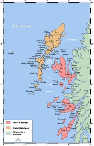 | |
| Outer Hebrides | ||
|  | ||||||||||||||||
|
| |||||||||||||||||
| |||||||||||||||||
| |||||||||||||||||
| |||||||||||||||||
| |||||||||||||||||
| |||||||||||||||||
| |||||||||||||||||
| Authority control |
|
|---|