Eflani
Eflani is a town and district of Karabük Province in the Black Sea region of Turkey. Eflani is located at 100 km south of the Black Sea. 46 km away from, and to the east of Karabük, it is settled on a plateau divided by small rivers among the high mountains and valleys. According to the 2000 census, population of the district is 12,270 of which 3,897 live in the town of Eflani.[3][4] The district covers an area of 587 km2 (227 sq mi),[5] and the town lies at an elevation of 897 m (2,943 ft).
Eflani | |
|---|---|
District | |
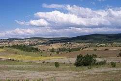 A view of Eflani district | |
 Location of Eflani within Turkey. | |
 Eflani Location of Eflani | |
| Coordinates: 41°25′N 32°57′E | |
| Country | |
| Region | Black Sea |
| Province | Karabük |
| Government | |
| • Mayor | İbrahim Ertuğrul (AKP) |
| Area | |
| • District | 586.62 km2 (226.50 sq mi) |
| Elevation | 897 m (2,943 ft) |
| Population (2012)[2] | |
| • Urban | 2,159 |
| • District | 9,108 |
| • District density | 16/km2 (40/sq mi) |
| Time zone | UTC+2 (EET) |
| • Summer (DST) | UTC+3 (EEST) |
| Postal code | 78xxx |
| Area code(s) | 370 |
| Licence plate | 78 |
| Climate | Cfb |
| Website | www.eflani.bel.tr |
History
In Eflani, the traces of past civilizations are the rock tombs, and mosques in the center in the periphery. Eflani served on the route connecting the Amasra colony with inner Anatolia in and the Middle Ages. Between 1292 and 1309, the town was center of the Jandarids.
Education
There are five school in Eflani. Eflani İMKB Çok Programlı Lisesi is one of them and English is a second language in this school.
Eflani today
Having a very rich vegetation due to its humid climate, Eflani serves as a promenade site for the region, with its forests and three ponds. For a certain period, the demand for animals and animal products in the region was met by Eflani, and today the animal breeding though lost its former significance, is still an important subsistence.
What makes Eflani significant in the province are the rich marble ores. The marbles are extracted as blocks and are exported by companies of private sector.
Image gallery
 On the way to Lake Bostancı
 A panorama of Lake Bostancı
Notes
- "Area of regions (including lakes), km²". Regional Statistics Database. Turkish Statistical Institute. 2002. Retrieved 2013-03-05.
- "Population of province/district centers and towns/villages by districts - 2012". Address Based Population Registration System (ABPRS) Database. Turkish Statistical Institute. Retrieved 2013-02-27.
- Turkish Statistical Institute. "Census 2000, Key statistics for urban areas of Turkey" (in Turkish). Archived from the original (XLS) on 2007-07-22. Retrieved 2008-11-18.
- GeoHive. "Statistical information on Turkey's administrative units". Retrieved 2008-11-21.
- Statoids. "Statistical information on districts of Turkey". Retrieved 2008-11-21.
References
- Falling Rain Genomics, Inc. "Geographical information on Eflani, Turkey". Retrieved 2008-11-17.
External links
| Wikimedia Commons has media related to Eflani. |
- District governor's official web site (in Turkish)
- Local website giving information on Eflani (in Turkish)
- Eflani News (in Turkish)
- Eflani introductory web site (in Turkish)
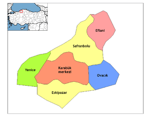
Eflani in Karabük Province of Turkey | |||||||||||||||||||||||||||
|---|---|---|---|---|---|---|---|---|---|---|---|---|---|---|---|---|---|---|---|---|---|---|---|---|---|---|---|
| Districts | Districts of Karabük | ||||||||||||||||||||||||||
| |||||||||||||||||||||||||||
Metropolitan municipalities are bolded. | |||||||||||||||||||||||||||