Ko Lan
Ko Lan (Thai: เกาะล้าน, pronounced [kɔ̀ʔ láːn]) is one of the eastern seaboard islands of Thailand. Ko Lan lies 7.5 km from the nearest shore, Pattaya. "Ko Lan" is the name of the island in the Royal Thai General System of Transcription. It is also known as "Koh Larn" and "Ko Laan".
Ko Lan เกาะล้าน | |
|---|---|
Island | |
 Ko Lan seen from the east. Ko Sak can be seen on the right side of the image. Ko Krok is the darker shape above the sailship | |
| Nickname(s): Coral Island | |
 Ko Lan | |
| Coordinates: 12°54′57″N 100°46′39″E | |
| Country | Thailand |
| Province | Chonburi |
| District | Bang Lamung |
| Village | List
|
| Area | |
| • Total | 5.6 km2 (2.2 sq mi) |
| • Land | 5.6 km2 (2.2 sq mi) |
| Dimensions | |
| • Length | 4.65 km (2.89 mi) |
| • Width | 2.15 km (1.34 mi) |
| Highest elevation | 180 m (590 ft) |
| Time zone | UTC+7 (ICT) |
| Area Code | 038 |
Geography
About four kilometres long and two kilometres wide occupying 3,411 rai,[1] Ko Lan is the largest of the "near islands" off south Pattaya, at the southeast end of the Bay of Bangkok, and on the east side of the Gulf of Siam. Administratively Ko Lan belongs to the Amphoe Bang Lamung, Chonburi Province.
It is an island of hills covered with low tropical forest. A Buddhist shrine is located at its highest point, 180 metres above sea level. The island has two small villages, Ban Ko Lan and Ban Krok Makhan, where there are lodgings and restaurants. Ferries connect Ko Lan to the mainland.
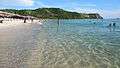
Most of Ko Lan's eight beaches are on its west side. Most visited is Tawaen Beach, where there is a small harbor. The beach is lined with small tourist shops and restaurants. Other beaches are Tonglang Beach, Tien Beach, Samae Beach, and Naon Beach.
Ko Lan has 1,567 hotel and resort rooms and two wharves.[1]
 Lan Island
- Ko Lan from the east
 Sunset, Ko Lan
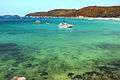 Tawaen Beach
The "Koh Larn Classic" is a sailing and running race event held at the nearby Royal Varuna Yacht Club in Pattaya.
Adjacent islands
Two smaller islands are near Ko Lan:
- Ko Sak (เกาะสาก), a narrow "c"-shaped island with a small bay open towards the north. It is 0.6 km off Ko Lan's northern tip. Its highest point is 33 m. It has a horseshoe-shaped beach in the north. Accommodation is available.
- Ko Krok (เกาะครก), a private island less than two kilometres to the east of Ko Lan's northeast shore. Its highest point is 41 m.
Ko Phai, the main island of Mu Ko Phai (หมู่เกาะไผ่), the group of "far islands", off Pattaya is about 14 km to the west of Ko Lan.[2]
Impact of mass tourism
During low season, Ko Lan attracts about 3,000 visitors a day. In high season, as many as 20,000 people daily visit. They generate about two million baht in daily income. Its maximum daily visitor capacity is 6,410.[1] In addition, there are up to 8,000 permanent residents and workers on the island. Visitors and island residents generate about 50 tonnes of solid waste per day, mostly waste from food and plastic containers, foam and glass bottles, but Pattaya City authorities are only able to remove 20–25 tonnes per day.[3][1] Pattaya City has no landfill of its own. It transports all of its waste and that of Ko Lan to a site in neighbouring Saraburi. The remaining daily 10 tonnes of refuse on Ko Lan is building up at a 12 rai sized dump site in the island's centre. There are over 50,000 tonnes of accumulated rubbish on the island.[1] Plans existed to build a garbage recycling and separation plant by 2016.[4] It has not happened.
See also
References
- Pupattanapong, Chaiyot (6 June 2018). "Koh Larn sullied by tourist overload as waste mounts". Bangkok Post. Retrieved 6 June 2018.
- Hydrographic Service of the Royal Thai Navy, Chart 142
- "Koh Larn rubbish crisis gets the "all talk, no action" policy treatment". Pattaya One. 2017-08-07. Archived from the original on 10 September 2017. Retrieved 7 August 2017.
- Yongcharoenchai, Chaiyot (2015-06-28). "Islanders left drowning under a sea of waste". Bangkok Post. Retrieved 29 June 2015.
External links
| Wikimedia Commons has media related to Ko Lan. |

- Planet Plastic: Thai citizens suffer from plastic addiction and poor waste management (Video)
- The Koh Larn website