East Northamptonshire
East Northamptonshire (officially "The District of East Northamptonshire") is a local government district in Northamptonshire, England. Its council is based in Thrapston and Rushden. Other towns include Oundle, Raunds, Irthlingborough and Higham Ferrers. The town of Rushden is the largest settlement in the district and the smallest settlement is the hamlet of Shotley. The population of the District Council at the 2011 Census was 86,765.[1]
District of East Northamptonshire | |
|---|---|
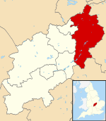 East Northamptonshire shown within Northamptonshire | |
| Sovereign state | United Kingdom |
| Constituent country | England |
| Region | East Midlands |
| Non-metropolitan county | Northamptonshire |
| Status | Non-metropolitan district |
| Admin HQ | Thrapston |
| Incorporated | 1 April 1974 |
| Government | |
| • Type | Non-metropolitan district council |
| • Body | East Northamptonshire Council |
| • Leadership | Alternative - Sec.31 (Conservative) |
| • MPs | Tom Pursglove Conservative Peter Bone Conservative |
| Area | |
| • Total | 196.8 sq mi (509.8 km2) |
| Area rank | 89th (of 317) |
| Population (mid-2019 est.) | |
| • Total | 94,527 |
| • Rank | 258th (of 317) |
| • Density | 480/sq mi (190/km2) |
| • Ethnicity | 98.3% White |
| Time zone | UTC0 (GMT) |
| • Summer (DST) | UTC+1 (BST) |
| ONS code | 34UD (ONS) E07000152 (GSS) |
| OS grid reference | TL0192784659 |
| Website | www |
 |
| East Northamptonshire District. (Shaded area is the county of Northamptonshire) |
The district borders onto the Borough of Corby, the Borough of Kettering, the Borough of Wellingborough, the Borough of Bedford, the City of Peterborough, the District of Huntingdonshire, South Kesteven District and the unitary authority county of Rutland.
The district was formed on 1 April 1974, under the Local Government Act 1972, by a merger of the municipal borough of Higham Ferrers, with the urban districts of Irthlingborough, Oundle, Raunds and Rushden, along with Oundle and Thrapston Rural District, and Newton Bromswold from Wellingborough Rural District.
Much of the district is home to Rockingham Forest, once a Royal hunting forest which takes its name from the village of Rockingham where William I built a castle.
The district is home to several of Northamptonshire's airfields including Spanhoe, King's Cliffe, Deenethorpe, Polebrook, Chelveston and Lyveden.
In March 2018, an independent report commissioned by the Secretary of State for Housing, Communities and Local Government, proposed structural changes to local government in Northamptonshire. These changes would see the existing county council and district councils abolished and two new unitary authorities created in their place.[2] One authority would consist of the existing districts of Daventry, Northampton and South Northamptonshire and the other authority would consist of Corby, East Northamptonshire, Kettering and Wellingborough districts.[3]
Geography
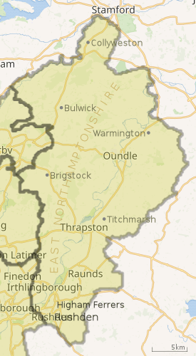
There are six towns in the district. Rushden is by far the largest with a population of 29,272. It is situated in the very south of the district and forms a single urban area with the neighbouring town of Higham Ferrers which has a population of 7,145. The second largest town in the district is Raunds, population 8,641 followed closely by Irthlingborough, population 8,535. The smallest town in the district is Thrapston where the HQ of the East Northamptonshire council is located. Oundle is a historical market town with many ancient buildings, including St Peter's parish church with the tallest spire in the county and a large Public School. Higham Ferrers, which is part of Rushden's urban area, was the birthplace for Henry Chichele and chichele college. Irthlingborough was home to Rushden & Diamonds Football Club before it went into liquidation.
There are no railway stations in East Northamptonshire. There is one College in East Northamptonshire.
Election results
2019 no election in any of the Northamptonshire districts, following a budgetary overspending crisis and subsequent plans to merge East Northamptonshire local authority with three other districts/boroughs to form a unitary authority of North Northamptonshire. In the meantime, councillors terms of office have been extended at least up to 2020.[4]
2015 (total 40 seats)
Conservative - 37 seats (+2) Labour - 1 seats (-1) Independent - 2 seats (-1)
2011 (total 40 seats)
Conservative - 35 seats (-4) Labour - 2 seats (+2) Independent - 3 seats (+2)
2007 (total 40 seats)
Conservative - 39 seats (+ 6) Labour - 0 seats ( - 3) Independent - 1 seat
2004 (total 36 seats)
Conservative - 33 seats (+ 12) Labour - 3 seats (- 12)
Settlements and parishes
- Achurch, Aldwincle, Apethorpe, Ashton
- Barnwell, Benefield, Blatherwycke, Brigstock, Bulwick
- Chelveston cum Caldecott, Clopton, Collyweston, Cotterstock
- Deene, Deenethorpe, Denford, Duddington-with-Fineshade
- Easton-on-the-Hill
- Fotheringhay
- Glapthorn, Great Addington
- Hargrave, Harringworth, Hemington, Higham Ferrers
- Irthlingborough, Islip
- King`s Cliffe
- Laxton, Lilford-cum-Wigsthorpe
- Little Addington, Lowick, Luddington, Lutton
- Nassington, Newton Bromswold
- Oundle
- Pilton, Polebrook
- Raunds, Ringstead, Rushden
- Shotley, Southwick, Stanwick, Stoke Doyle, Sudborough
- Tansor, Thrapston, Thurning, Thorpe Waterville, Titchmarsh, Thorpe Achurch, Twywell
- Wadenhoe, Wakerley, Warmington, Woodford, Woodnewton
- Yarwell
See also
References
- "District population 2011". Neighbourhood Statistics. Office for National Statistics. Retrieved 27 June 2016.
- https://www.bbc.co.uk/news/uk-england-northamptonshire-40610349
- http://www.itv.com/news/anglia/2018-03-15/northamptonshire-county-council-should-be-split-up-finds-damning-report/
- "Northamptonshire County Council: No local elections for cash-crisis county". BBC News. 1 May 2019.
External links
- Nene Valley News Community Newspaper
- Extra Local Newspaper
- East Northamptonshire Council Local Authority
| Wikimedia Commons has media related to East Northamptonshire. |
England Portal | |
| Boroughs or districts | |
| Major settlements | |
| Rivers | |
| Canals | |
| Topics | |
