Grade II* listed buildings in East Northamptonshire
There are over 20,000 Grade II* listed buildings in England. This page is a list of these buildings in the district of East Northamptonshire in Northamptonshire.
East Northamptonshire
| Name | Location | Type | Completed [note 1] | Date designated | Grid ref.[note 2] Geo-coordinates |
Entry number [note 3] | Image |
|---|---|---|---|---|---|---|---|
| Ashton Mill | Ashton, East Northamptonshire | Corn Mill | C17-19 | 12 May 1969 | TL0516688217 52°28′54″N 0°27′10″W |
1040278 | 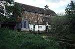 Ashton Mill |
| Home Farm Cottage | Ashton Wold, Ashton | House | 1900–1901 | 13 November 1998 | TL0892987904 52°28′42″N 0°23′51″W |
1245640 |  |
| Home Farm, Farmbuildings | Ashton Wold, Ashton | Dovecote | 1900–1901 | 13 November 1998 | 49°46′01″N 7°33′26″W | 1271732 | |
| Home Farm, the Old Dairy | Ashton Wold, Ashton | Dairy | 1900–1901 | 13 November 1998 | TL0895287896 52°28′41″N 0°23′50″W |
1271734 | |
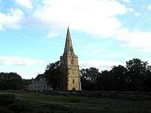
| All Saints Chancel | Barnwell All Saints, Barnwell | Church | 13th century | 23 May 1967 | TL0486984417 52°26′52″N 0°27′30″W |
1294446 | 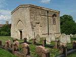 All Saints Chancel |
| Biggin Hall | Benefield | Country House | Medieval origins | 23 May 1967 | TL0108889137 52°29′27″N 0°30′45″W |
1040213 | 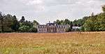 Biggin Hall |
| Church of St Mary | Lower Benefield, Benefield | Church | Medieval | 23 May 1967 | SP9881288470 52°29′07″N 0°32′47″W |
1189042 | 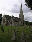 Church of St Mary |
| Church of the Holy Trinity | Blatherwycke | Church | 11th century to 14th century | 23 May 1967 | SP9743595762 52°33′04″N 0°33′52″W |
1040093 | |
| Fermyn Woods Hall, and attached Stables and ancillary Buildings | Brigstock | Country House | Early/mid 17th century | 23 May 1967 | SP9581687120 52°28′25″N 0°35′27″W |
1189160 | 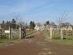 Fermyn Woods Hall, and attached Stables and ancillary Buildings |
| Manor House | Brigstock | Hall House | 12th-century origins | 26 May 1967 | SP9452785228 52°27′25″N 0°36′37″W |
1040166 | |
| Bulwick Hall and attached Entrance Loggia and Garden Room | Bulwick Park, Bulwick | Country House | c. 1676 | 23 May 1967 | SP9588794050 52°32′09″N 0°35′16″W |
1293383 |  Bulwick Hall and attached Entrance Loggia and Garden Room |
| Gates and Gatepiers about 150m south-west of Bulwick Hall | Bulwick Park, Bulwick | Gate | Early 18th century | 23 May 1967 | SP9580293904 52°32′05″N 0°35′21″W |
1374888 | |
| Church of St John the Baptist | Caldecott, Chelveston cum Caldecott | Church | Mid 13th century | 23 May 1967 | SP9884569126 52°18′41″N 0°33′05″W |
1040380 | 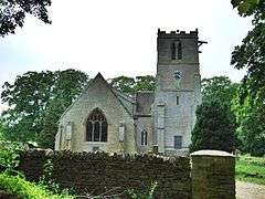 Church of St John the Baptist |
| Church of St Andrew | Collyweston | Church | 11th century | 23 May 1967 | SK9960702885 52°36′53″N 0°31′49″W |
1374873 | 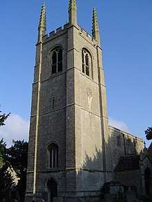 Church of St Andrew |
| Church of St Peter | Deene Park, Deene | Bust | 1722 | 23 May 1967 | SP9519092748 52°31′27″N 0°35′54″W |
1040134 | |
| Church of St Mary | Duddington, Duddington-with-Fineshade | Church | mid and late 12th century | 23 May 1967 | SK9877400884 52°35′48″N 0°32′35″W |
1040104 | 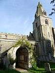 Church of St Mary |
| Glebe House and attached Steps and Railings | Easton on the Hill | House | 1988 | 23 May 1967 | TF0093704591 52°37′47″N 0°30′36″W |
1225510 | |
| Priest's House | Easton on the Hill | Priests House | Early 16th century | 23 May 1967 | TF0097204548 52°37′46″N 0°30′35″W |
1225369 | 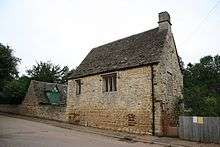 Priest's House |
| RAF Wittering: Nuclear Fissile Core Stores, Buildings A09, A10, A11, A14, A15, A27, VW28, A29 and A33 | Easton on the Hill, East Northamptonshire | Nuclear Fissile Core Store | Built 1952 | 11 July 2011 | 49°46′01″N 7°33′26″W | 1402763 | |
| Church of St Leonard | Glapthorn | Church | 12th century | 23 May 1967 | TL0242290202 52°30′00″N 0°29′33″W |
1371965 | 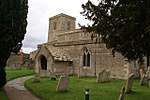 Church of St Leonard |
| Church of All Saints | Great Addington | Church | 12th century | 23 May 1967 | SP9586275114 52°21′57″N 0°35′37″W |
1040381 | 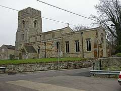 Church of All Saints |
| Church of All Saints and Chest Tomb attached to North Aisle | Hargrave | Church | Late 12th century | 23 May 1967 | TL0365970638 52°19′27″N 0°28′50″W |
1191820 | 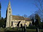 Church of All Saints and Chest Tomb attached to North Aisle |
| Harringworth Lodge | Harringworth | Hunting Lodge | 13th century origins | 23 May 1967 | SP9320895269 52°32′50″N 0°37′37″W |
1040116 | .jpg) Harringworth Lodge |
| Church of St Peter and St Paul | Hemington | Church | 13th-century origins | 23 May 1967 | TL0918884996 52°27′07″N 0°23′41″W |
1040226 | 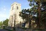 Church of St Peter and St Paul |
| College House | Higham Ferrers | House | 1633 | 23 September 1950 | SP9604668651 52°18′27″N 0°35′34″W |
1040389 | |
| 5 Market Square | Higham Ferrers | House | Mid 17th century | 23 September 1950 | SP9601968497 52°18′22″N 0°35′35″W |
1371874 | |
| Hall Farmhouse | King's Cliffe | Farmhouse | Late Medieval | 23 May 1967 | TL0075997066 52°33′44″N 0°30′54″W |
1225654 | |
| Church of All Saints | Laxton | Church | 12th century | 23 May 1967 | SP9505596011 52°33′13″N 0°35′58″W |
1233912 | 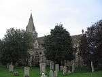 Church of All Saints |
| Laxton Hall and attached Steps and Balustrade | Laxton Park, Laxton | Country House | Late 18th century | 23 May 1967 | SP9597997065 52°33′47″N 0°35′08″W |
1276360 | .jpg) Laxton Hall and attached Steps and Balustrade |
| Church of St John the Baptist | Slipton, Lowick | Church | 13th century | 23 May 1967 | SP9525779341 52°24′14″N 0°36′04″W |
1040269 | .jpg) Church of St John the Baptist |
| Flight of Steps with Urns adjacent to north Front of Drayton House | Drayton Park, Lowick | Steps | Early 18th century | 31 July 1987 | SP9630680064 52°24′36″N 0°35′08″W |
1040297 | |
| Flight of Steps with Urns about 90m east of east Front of Drayton House | Drayton Park, Lowick, East Northamptonshire | Steps | Early 18th century | 31 July 1987 | SP9637680132 52°24′39″N 0°35′04″W |
1040301 | |
| Retaining Wall, Steps and Urns extending about 80m from south to east Front of Drayton House | Drayton Park, Lowick | Garden Wall | Late 16th century | 31 July 1987 | SP9637580078 52°24′37″N 0°35′05″W |
1040299 | |
| Stables attached to south-west of Drayton House | Drayton Park, Lowick | Wall | mid/late 17th century | 23 May 1967 | SP9636079957 52°24′33″N 0°35′05″W |
1192040 | |
| Statue of Bacchus about 25m east of east Front of Drayton House | Drayton Park, Lowick | Statue | c. 1718 | 31 July 1987 | SP9633280100 52°24′38″N 0°35′07″W |
1371924 | |
| Statue of Flora around 25m east of east Front of Drayton House | Drayton Park, Lowick | Statue | c. 1718 | 31 July 1987 | SP9635780087 52°24′37″N 0°35′05″W |
1192227 | |
| Statue of Samson and the Philistine about 110m east of east Front of Drayton House | Drayton Park, Lowick, East Northamptonshire | Statue | Early 18th century | 31 July 1987 | SP9639480155 52°24′39″N 0°35′03″W |
1371923 | |
| Walls, Gatepier and attached Banqueting House and Balustrade about 80m east of Drayton House | Drayton Park, Lowick, East Northamptonshire | Balustrade | Late 17th century | 23 May 1967 | SP9634780146 52°24′39″N 0°35′06″W |
1040298 | |
| Walls, Gatepiers, Gates and Screens south and east of Drayton House; and Banqueting House, Balustrade, Statue and Cistern | Drayton Park, Lowick | Balustrade | late C17/early 18th century | 23 May 1967 | SP9646079966 52°24′33″N 0°35′00″W |
1371922 | |
| Church of St Margaret | Luddington-in-the-Brook, Luddington | Church | 13th century to 15th century | 23 May 1967 | TL1031383665 52°26′23″N 0°22′43″W |
1040228 | 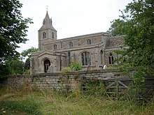 Church of St Margaret |
| Manor House | Nassington | Manor House | Early 16th century | 23 May 1967 | TL0628896176 52°33′11″N 0°26′02″W |
1065895 | |
| Bramston House Central Building | Oundle | House | Late 17th century | 18 June 1955 | TL0420088072 52°28′50″N 0°28′02″W |
1039859 | |
| Bramston House East Wing | Oundle | House | 18th century | 18 June 1955 | TL0421588086 52°28′51″N 0°28′01″W |
1039860 | |
| Branston House West Wing | Oundle | House | Early 18th century | 18 June 1955 | TL0418788062 52°28′50″N 0°28′02″W |
1190599 | |
| Latham's Hospital | Oundle | Almshouses | 1830 | 18 June 1955 | TL0428588308 52°28′58″N 0°27′57″W |
1039800 | .jpg) Latham's Hospital |
| Oundle School Memorial Chapel | Oundle | School | 1922-3 | 7 June 1974 | TL0383388338 52°28′59″N 0°28′21″W |
1039825 | |
| Paine's Almshouses | Oundle | Wall | Early 17th century | 18 June 1955 | TL0384788113 52°28′52″N 0°28′20″W |
1039816 | |
| Stable Block and Barn to West of No 16 including linking Wall and Gate Piers | Oundle | Gate | 18 June 1955 | TL0400588065 52°28′50″N 0°28′12″W |
1039780 | | |
| The White Lion Public House | Oundle | Public House | Early 17th century | 18 June 1955 | TL0425588164 52°28′53″N 0°27′59″W |
1039840 | |
| Upper House | Oundle | House | 18 June 1955 | TL0426488191 52°28′54″N 0°27′58″W |
1039841 | | |
| 12 North Street | Oundle | House | 1661 | 7 June 1974 | TL0425788183 52°28′54″N 0°27′58″W |
1293575 | |
| 4 and 6 Market Place | Oundle | House | Early 18th century | 18 June 1955 | TL0412588075 52°28′50″N 0°28′06″W |
1293722 | |
| 13 Market Place | Oundle | House | Late 17th century | 18 June 1955 | TL0416788112 52°28′52″N 0°28′03″W |
1372120 | |
| Church of St Mary and All Saints | Pilton | Church | Late 12th century | 23 May 1967 | TL0247784546 52°26′57″N 0°29′37″W |
1294190 | 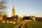 Church of St Mary and All Saints |
| Churchyard Cross about 8m south of South Aisle of Church of St Peter | Raunds | Cross | 14th century or 15th century | 26 April 1950 | TL0004073068 52°20′48″N 0°31′58″W |
1371901 | |
| No 59, Thorpe St (Thorpe House) and attached Wall to South | Raunds | Farmhouse | Mid 16th century | 26 April 1950 | SP9989472344 52°20′24″N 0°32′07″W |
1040345 | |
| Rushden Hall | Rushden | Country House/Offices | 14th century or 15th century | 9 December 1949 | SP9560566323 52°17′12″N 0°35′59″W |
1225991 | |
| Church of St Mary | Southwick | Church | 14th century | 23 May 1967 | TL0208592081 52°31′01″N 0°29′49″W |
1190967 | 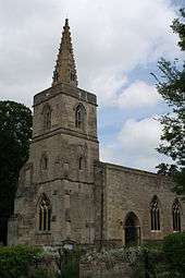 Church of St Mary |
| Stanwick Hall | Stanwick | Country House | 17th century | 26 April 1950 | SP9753171197 52°19′49″N 0°34′13″W |
1192263 | |
| The Old Rectory | Stanwick | House | 1717 | 26 April 1950 | SP9793571469 52°19′57″N 0°33′51″W |
1286673 | |
| Church of St Rumbald | Stoke Doyle | Church | c1722-25 | 23 May 1967 | TL0265486261 52°27′53″N 0°29′26″W |
1040178 | 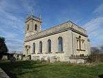 Church of St Rumbald |
| Church of All Saints | Sudborough | Cross | Saxon | 23 May 1967 | SP9676882108 52°25′42″N 0°34′42″W |
1226485 | 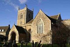 Church of All Saints |
| Church of St Mary the Virgin | Tansor | Church | Late 11th century | 23 May 1967 | TL0535390894 52°30′21″N 0°26′57″W |
1191175 | 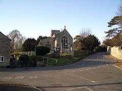 Church of St Mary the Virgin |
| Church of St John the Baptist | Achurch, Thorpe Achurch | Church | Early 13th century | 23 May 1967 | TL0213883136 52°26′12″N 0°29′56″W |
1040142 | 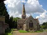 Church of St John the Baptist |
| Church of St James | Thrapston | Church | 13th century | 23 May 1967 | SP9970378698 52°23′50″N 0°32′10″W |
1265715 | 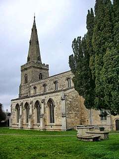 Church of St James |
| Church of St Nicholas | Twywell | Church | 12th century | 23 May 1967 | SP9518078183 52°23′36″N 0°36′10″W |
1226021 | 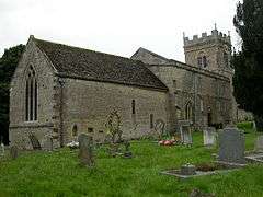 Church of St Nicholas |
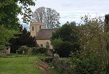
| Church of St Michael and All Angels | Wadenhoe | Church | Late 12th century | 23 May 1967 | TL0086383284 52°26′18″N 0°31′04″W |
1227141 | .jpg) Church of St Michael and All Angels |
| Manor House | Warmington | Manor House | 1677 | 23 May 1967 | TL0770391284 52°30′32″N 0°24′52″W |
1191298 | 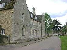 Manor House |
| Manor House Farmhouse | Woodford | Farmhouse | 1987 | 23 May 1967 | SP9666776838 52°22′52″N 0°34′52″W |
1225978 | |
| Church of St Mary | Woodnewton | Church | 11th century to 15th century | 23 May 1967 | TL0321094572 52°32′21″N 0°28′47″W |
1065862 | 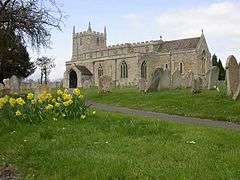 Church of St Mary |
| Church of St Mary Magdalene | Yarwell | Church | 13th century | 23 May 1967 | TL0709497761 52°34′02″N 0°25′17″W |
1225878 | 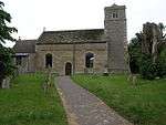 Church of St Mary Magdalene |
Notes
- The date given is the date used by Historic England as significant for the initial building or that of an important part in the structure's description.
- Sometimes known as OSGB36, the grid reference is based on the British national grid reference system used by the Ordnance Survey.
- The "List Entry Number" is a unique number assigned to each listed building and scheduled monument by Historic England.
External links
![]()
This article is issued from Wikipedia. The text is licensed under Creative Commons - Attribution - Sharealike. Additional terms may apply for the media files.