Doğankent
Doğankent is a town and a district of Giresun Province in the Black Sea region of Turkey.
Doğankent | |
|---|---|
 Doğankent | |
| Coordinates: 40°48′27″N 38°55′2″E | |
| Country | Turkey |
| Province | Giresun |
| Government | |
| • Mayor | Haşim Birol Tekin (MHP) |
| • Kaymakam | Naif Yavuz |
| Area | |
| • District | 122.86 km2 (47.44 sq mi) |
| Elevation | 541 m (1,775 ft) |
| Population (2012)[2] | |
| • Urban | 3,475 |
| • District | 6,806 |
| • District density | 55/km2 (140/sq mi) |
| Post code | 28510 |
| Climate | Cfa |
| Website | www.dogankent.bel.tr |
Geography
Doğankent is a hilly district in the valley of the Harşit. The climate is typical of the Black Sea region; lots of rain, summer and winter.
Doğankent is a small town of 3,383 people, providing high schools and other basic amenities to the surrounding villages.
Etymology
Previously known as Kürtün-ü Zir, Manastır Bükü and Harşit.
History
There was a monastery here in the Byzantine period, hence the earlier name. The area was settled by Seljuk Turks following their victory over the Byzantines at the Battle of Malazgirt and was then absorbed into the Ottoman Empire in 1461 by Sultan Mehmet II during his conquest of the rump-Byzantine Empire of Trebizond. The areas importance as a centre of education persisted as the monasteries were converted into Islamic medrese.
See also
References
- "Area of regions (including lakes), km²". Regional Statistics Database. Turkish Statistical Institute. 2002. Retrieved 2013-03-05.
- "Population of province/district centers and towns/villages by districts - 2012". Address Based Population Registration System (ABPRS) Database. Turkish Statistical Institute. Retrieved 2013-02-27.
External links
(follow resim, resimler or foto galeri in the Turkish websites for pictures)
- the municipality
- (in Turkish) the district governorate
- (in Turkish) local information
Doğankent in Giresun Province of Turkey | |||||||||||||||||||||||||||
|---|---|---|---|---|---|---|---|---|---|---|---|---|---|---|---|---|---|---|---|---|---|---|---|---|---|---|---|
| Districts | 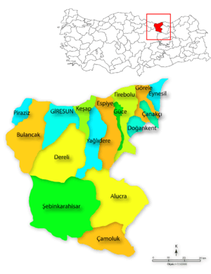 Districts of Giresun | ||||||||||||||||||||||||||
| |||||||||||||||||||||||||||
Metropolitan municipalities are bolded. | |||||||||||||||||||||||||||