Demirköy, Kırklareli
Demirköy (Turkish: Demirköy, "iron village"; known as Малък Самоков, Malak Samokov in Bulgarian) is a town and district of Kırklareli Province in the Marmara region of Turkey. According to the Ottoman population statistics of 1914, the kaza of Demirköy had a total population of 9.133, consisting of 5.110 Greeks and 4.023 Muslims.[3] The inhabitants are mainly descendants of Muslims from the village of Tisovo and other villages from the Greek side of the Chech region who were settled in Demirköy during the population exchange between Greece and Turkey in 1923/1924. Prior to that, the village was known as Samakovo (Greek: Σαμάκοβο) or Samokov (Bulgarian: Самоков).
Demirköy | |
|---|---|
 Demirköy | |
| Coordinates: 41°49′21″N 27°45′47″E | |
| Country | |
| Region | Marmara Region |
| Province | Kırklareli |
| Government | |
| • Mayor | Muhlis Yavuz (MHP) |
| • Kaymakam | Fatih Yılmaz |
| Area | |
| • District | 876.76 km2 (338.52 sq mi) |
| Population (2012)[2] | |
| • Urban | 3,838 |
| • District | 8,782 |
| • District density | 10/km2 (26/sq mi) |
| Climate | Cfb |
| Website | www.demirkoy.bel.tr |
The mayor is Muhlis Yavuz (MHP). The population is 3,719 (as of 2010).
Visitor attractions

A historic metalworking facility dating back to the 15th century, the Demirköy Foundry (Turkish: Demirköy Dökümhanesi), currently an archaeological site, is located 3.8 km (2.4 mi) southeast of Demirköy.[4]
The Dupnisa Cave (Turkish: Dupnisa Mağarası) is a show cave located deep in the Strandzha forests 25 km (16 mi) southwest of the town.[5]
The İğneada Floodplain Forests National Park (Turkish: İğneada Longoz Ormanları Milli Parkı) is at 25 km (16 mi) east of Demirköy near İğneada.[6] The Lake Saka Nature Reserve is situated inside the national park.[7]
References
- "Area of regions (including lakes), km²". Regional Statistics Database. Turkish Statistical Institute. 2002. Retrieved 2013-03-05.
- "Population of province/district centers and towns/villages by districts - 2012". Address Based Population Registration System (ABPRS) Database. Turkish Statistical Institute. Retrieved 2013-02-27.
- Kemal Karpat (1985), Ottoman Population, 1830-1914, Demographic and Social Characteristics, The University of Wisconsin Press, p. 170-171
- "Demirköy (Samakocuk) Fatih Dökümhanesi" (in Turkish). Kırklareli Kültür Varlıkları Envanteri. Retrieved 2015-07-16.
- "Dupnisa Mağarası - Kırklareli" (in Turkish). Kültür ve Turizm Bakanlığı-Yatırım ve İşletmeler Genel Müdürlüğü. Retrieved 2015-07-16.
- "İğneada Longoz Ormanları Milli Parkı" (in Turkish). Doğa Koruma ve Milli Parklar Genel Müdürlüğü. Archived from the original on 2013-11-23. Retrieved 2015-07-16.
- "Kırklareli Kültür ve Tabiat Varlığı - Saka Gölü Tabiatı Koruma Alanı" (in Turkish). Kırklareli Yerel Net. Retrieved 2015-07-16.
Demirköy, Kırklareli in Kırklareli Province of Turkey | |||||||||||||||||||||||||||
|---|---|---|---|---|---|---|---|---|---|---|---|---|---|---|---|---|---|---|---|---|---|---|---|---|---|---|---|
| Districts | 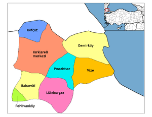 Districts of Kırklareli | ||||||||||||||||||||||||||
| |||||||||||||||||||||||||||
Metropolitan municipalities are bolded. | |||||||||||||||||||||||||||